Bridge Statistics for Oak Grove, Kentucky (KY)
Condition, Traffic, Stress, Structural Evaluation, Project Costs
- National Bridge Inventory (NBI) Statistics
- 16Number of bridges
- 223ft / 68.0mTotal length
- 335,039Total average daily traffic
- 70,458Total average daily truck traffic
- National Bridge Inventory (NBI) Registered Bridges for Oak Grove
- No street view available for this location
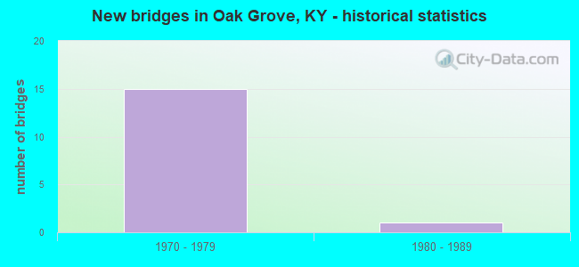
- New bridges - historical statistics
- 151970-1979
- 11980-1989


- Bridge Condition - Deck
- 11.1%Very good
- 44.4%Good
- 22.2%Satisfactory
- 22.2%Fair

- Bridge Condition - Superstructure
- 55.6%Good
- 33.3%Satisfactory
- 11.1%Fair

- Bridge Condition - Substructure
- 44.4%Good
- 33.3%Satisfactory
- 22.2%Fair

- Bridge Condition - Channel
- 50.0%Very good
- 50.0%Good
Find on map >> Show street view
Structure Number: 24B00129L, Location: WBL US41A INTERCHANGE (Lat: 36.703056, Lng: -87.455000), Route carried "on" structure: Interstate 24, Year Built: 1974, Status: Open, Structure Length: 9.57m (31.40ft), Average Daily Traffic: 15,947 (year 2020), Truck Traffic: 25%, Average Future Daily Traffic: 19,455 (year 2040), Design Load: HS 20, Features Intersected: US 41A
Minimum Vertical Clearance: 30+ m (98+ ft), Kilometerpoint: 137.763, Lanes on structure: 2, Lanes under structure: 6, Base Highway Network: Yes, Owner: State Highway Agency, Approaching Roadway Width: 11.9m (39.0ft), Skew: 13 degrees, Material/Design: Steel continuous, Design/Construction: Stringer/Multi-beam, Number Of Spans In Main Unit: 2, Length of Maximum Span: 37.5m (123.0ft), Curb-To-Curb Width: 14.4m (47.2ft), Out-to-Out Width: 15.4m (50.5ft)
Condition: Deck: Satisfactory, Superstructure: Good, Substructure: Satisfactory, Operating Rating: 61.4 metric tons, Method Used To Determine Operating Rating: Load Factor (LF), Inventory Rating: 36.8 metric tons, Method Used To Determine Inventory Rating: Load Factor (LF), Structural Evaluation: Equal to present minimum criteria, Deck Geometry: Superior to present desirable criteria, Underclear: Somewhat better than minimum adequacy, Approach Roadway Alignment: Equal to present minimum criteria, Designated Inspection Frequency: Every 24 months, Inspection Date: June 2021, Deck Structure Type: Concrete Cast-file-Place, Wearing Surface/Protective System: Wearing Surface: Latex Concrete
Find on map >> Show street view
Structure Number: 24B00129R, Location: EBL OVER 41A INTERCHANGE (Lat: 36.702778, Lng: -87.455000), Route carried "on" structure: Interstate 24, Year Built: 1974, Status: Open, Structure Length: 9.57m (31.40ft), Average Daily Traffic: 15,947 (year 2020), Truck Traffic: 25%, Average Future Daily Traffic: 19,455 (year 2040), Design Load: HS 20, Features Intersected: US 41A
Minimum Vertical Clearance: 30+ m (98+ ft), Kilometerpoint: 137.773, Lanes on structure: 2, Lanes under structure: 6, Base Highway Network: Yes, Owner: State Highway Agency, Approaching Roadway Width: 14.9m (48.9ft), Skew: 13 degrees, Material/Design: Steel continuous, Design/Construction: Stringer/Multi-beam, Number Of Spans In Main Unit: 2, Length of Maximum Span: 37.5m (123.0ft), Curb-To-Curb Width: 14.4m (47.2ft), Out-to-Out Width: 15.4m (50.5ft)
Condition: Deck: Satisfactory, Superstructure: Good, Substructure: Satisfactory, Operating Rating: 61.4 metric tons, Method Used To Determine Operating Rating: Load Factor (LF), Inventory Rating: 36.8 metric tons, Method Used To Determine Inventory Rating: Load Factor (LF), Structural Evaluation: Equal to present minimum criteria, Deck Geometry: Superior to present desirable criteria, Underclear: Somewhat better than minimum adequacy, Approach Roadway Alignment: Equal to present minimum criteria, Designated Inspection Frequency: Every 24 months, Inspection Date: June 2021, Deck Structure Type: Concrete Cast-file-Place, Wearing Surface/Protective System: Wearing Surface: Latex Concrete
Find on map >> Show street view
Structure Number: 24B00130L, Location: WBL .10 MI E OF US 41A (Lat: 36.700000, Lng: -87.447778), Route carried "on" structure: Interstate 24, Year Built: 1974, Status: Open, Structure Length: 5.30m (17.39ft), Average Daily Traffic: 20,369 (year 2019), Truck Traffic: 18%, Average Future Daily Traffic: 24,850 (year 2039), Design Load: HS 20+Mod, Features Intersected: ND (NAT DEFENSE) RAILROA
Minimum Vertical Clearance: 30+ m (98+ ft), Kilometerpoint: 138.471, Lanes on structure: 2, Base Highway Network: Yes, Owner: State Highway Agency, Approaching Roadway Width: 11.9m (39.0ft), Skew: 14 degrees, Material/Design: Prestressed concrete continuous, Design/Construction: Stringer/Multi-beam, Number Of Spans In Main Unit: 3, Length of Maximum Span: 17.1m (56.1ft), Curb-To-Curb Width: 12.1m (39.7ft), Out-to-Out Width: 13.0m (42.7ft)
Condition: Deck: Good, Superstructure: Good, Substructure: Good, Operating Rating: 70.3 metric tons, Method Used To Determine Operating Rating: Load Factor (LF), Inventory Rating: 42.2 metric tons, Method Used To Determine Inventory Rating: Load Factor (LF), Structural Evaluation: Better than present minimum criteria, Deck Geometry: Equal to present minimum criteria, Approach Roadway Alignment: Equal to present desirable criteria, Designated Inspection Frequency: Every 24 months, Inspection Date: June 2021, Deck Structure Type: Concrete Cast-file-Place, Wearing Surface/Protective System: Wearing Surface: Latex Concrete
Find on map >> Show street view
Structure Number: 24B00130R, Location: EBL .10 MI E OF US 41A (Lat: 36.699722, Lng: -87.447778), Route carried "on" structure: Interstate 24, Year Built: 1974, Status: Open, Structure Length: 5.30m (17.39ft), Average Daily Traffic: 20,369 (year 2019), Truck Traffic: 18%, Average Future Daily Traffic: 24,850 (year 2039), Design Load: HS 20+Mod, Features Intersected: ND (NAT DEFENSE) RAILROA
Minimum Vertical Clearance: 30+ m (98+ ft), Kilometerpoint: 138.502, Lanes on structure: 2, Base Highway Network: Yes, Owner: State Highway Agency, Approaching Roadway Width: 11.9m (39.0ft), Skew: 14 degrees, Material/Design: Prestressed concrete continuous, Design/Construction: Stringer/Multi-beam, Number Of Spans In Main Unit: 3, Length of Maximum Span: 17.1m (56.1ft), Curb-To-Curb Width: 12.1m (39.7ft), Out-to-Out Width: 13.0m (42.7ft)
Condition: Deck: Very good, Superstructure: Good, Substructure: Good, Operating Rating: 70.3 metric tons, Method Used To Determine Operating Rating: Load Factor (LF), Inventory Rating: 42.2 metric tons, Method Used To Determine Inventory Rating: Load Factor (LF), Structural Evaluation: Better than present minimum criteria, Deck Geometry: Equal to present minimum criteria, Approach Roadway Alignment: Equal to present desirable criteria, Designated Inspection Frequency: Every 24 months, Inspection Date: June 2021, Deck Structure Type: Concrete Cast-file-Place, Wearing Surface/Protective System: Wearing Surface: Latex Concrete
Find on map >> Show street view
Structure Number: 24B00131N, Location: 1 MI S OF JCT KY 109 (Lat: 36.681944, Lng: -87.404444), Route carried "on" structure: State highway 115, Year Built: 1974, Status: Open, Structure Length: 7.62m (25.00ft), Average Daily Traffic: 10,201 (year 2019), Truck Traffic: 3%, Average Future Daily Traffic: 8,976 (year 2039), Design Load: H 20, Features Intersected: I 24, Facility Carried by Structure: PEMBROKE ROAD
Minimum Vertical Clearance: 30+ m (98+ ft), Kilometerpoint: 4.669, Lanes on structure: 2, Lanes under structure: 4, Owner: State Highway Agency, Approaching Roadway Width: 6.7m (22.0ft), Skew: 1 degrees, Material/Design: Steel continuous, Design/Construction: Stringer/Multi-beam, Number Of Spans In Main Unit: 2, Length of Maximum Span: 31.4m (103.0ft), Curb or Sidewalk Widths: Left: 0.2m (0.7ft), Right: 0.2m (0.7ft), Curb-To-Curb Width: 10.3m (33.8ft), Out-to-Out Width: 11.4m (37.4ft)
Condition: Deck: Fair, Superstructure: Satisfactory, Substructure: Fair, Operating Rating: 57.9 metric tons, Method Used To Determine Operating Rating: Load Factor (LF), Inventory Rating: 34.7 metric tons, Method Used To Determine Inventory Rating: Load Factor (LF), Structural Evaluation: Somewhat better than minimum adequacy, Deck Geometry: Meets minimum limits, Underclear: Equal to present minimum criteria, Approach Roadway Alignment: Equal to present desirable criteria, Designated Inspection Frequency: Every 24 months, Inspection Date: June 2021, Deck Structure Type: Concrete Cast-file-Place, Wearing Surface/Protective System: Wearing Surface: Monolithic Concrete
Find on map >> Show street view
Structure Number: 24B00132L, Location: WBL 2.0 MI NW OF TENN ST (Lat: 36.656944, Lng: -87.368889), Route carried "on" structure: Interstate 24, Year Built: 1974, Status: Open, Structure Length: 9.91m (32.51ft), Average Daily Traffic: 19,078 (year 2020), Truck Traffic: 27%, Average Future Daily Traffic: 23,275 (year 2040), Design Load: HS 20+Mod, Features Intersected: WEST FORK RED RIVER
Minimum Vertical Clearance: 30+ m (98+ ft), Kilometerpoint: 147.107, Lanes on structure: 2, Base Highway Network: Yes, Owner: State Highway Agency, Approaching Roadway Width: 11.9m (39.0ft), Material/Design: Steel continuous, Design/Construction: Stringer/Multi-beam, Number Of Spans In Main Unit: 3, Length of Maximum Span: 39.6m (129.9ft), Curb-To-Curb Width: 11.9m (39.0ft), Out-to-Out Width: 13.0m (42.7ft)
Condition: Deck: Good, Superstructure: Good, Substructure: Good, Channel: Very good, Operating Rating: 58.8 metric tons, Method Used To Determine Operating Rating: Load Factor (LF), Inventory Rating: 35.3 metric tons, Method Used To Determine Inventory Rating: Load Factor (LF), Structural Evaluation: Better than present minimum criteria, Deck Geometry: Equal to present minimum criteria, Waterway Adequacy: Better than present minimum criteria, Approach Roadway Alignment: Equal to present desirable criteria, Designated Inspection Frequency: Every 24 months, Inspection Date: June 2021, Deck Structure Type: Concrete Cast-file-Place, Wearing Surface/Protective System: Wearing Surface: Latex Concrete
Find on map >> Show street view
Structure Number: 24B00132R, Location: EBL 2.0 MI NW OF TENN ST (Lat: 36.656667, Lng: -87.369167), Route carried "on" structure: Interstate 24, Year Built: 1974, Status: Open, Structure Length: 9.91m (32.51ft), Average Daily Traffic: 19,078 (year 2020), Truck Traffic: 27%, Average Future Daily Traffic: 23,275 (year 2040), Design Load: HS 20+Mod, Features Intersected: WEST FORK RED RIVER
Minimum Vertical Clearance: 30+ m (98+ ft), Kilometerpoint: 147.107, Lanes on structure: 2, Base Highway Network: Yes, Owner: State Highway Agency, Approaching Roadway Width: 11.9m (39.0ft), Material/Design: Steel continuous, Design/Construction: Stringer/Multi-beam, Number Of Spans In Main Unit: 3, Length of Maximum Span: 39.6m (129.9ft), Curb-To-Curb Width: 11.9m (39.0ft), Out-to-Out Width: 13.0m (42.7ft)
Condition: Deck: Good, Superstructure: Satisfactory, Substructure: Good, Channel: Very good, Operating Rating: 58.8 metric tons, Method Used To Determine Operating Rating: Load Factor (LF), Inventory Rating: 35.3 metric tons, Method Used To Determine Inventory Rating: Load Factor (LF), Structural Evaluation: Equal to present minimum criteria, Deck Geometry: Equal to present minimum criteria, Waterway Adequacy: Equal to present desirable criteria, Approach Roadway Alignment: Equal to present desirable criteria, Designated Inspection Frequency: Every 24 months, Inspection Date: June 2021, Deck Structure Type: Concrete Cast-file-Place, Wearing Surface/Protective System: Wearing Surface: Latex Concrete
Find on map >> Show street view
Structure Number: 24B00141N, Location: .25 MI NW OF JCT CR 5187 (Lat: 36.671111, Lng: -87.351667), Route carried "on" structure: State highway 1881, Year Built: 1979, Status: Posted for load, Structure Length: 6.10m (20.01ft), Average Daily Traffic: 301 (year 2018), Average Future Daily Traffic: 261 (year 2038), Design Load: HS 15, Features Intersected: WEST FORK RED RIVER
Minimum Vertical Clearance: 30+ m (98+ ft), Kilometerpoint: 3.722, Lanes on structure: 2, Owner: State Highway Agency, Approaching Roadway Width: 6.7m (22.0ft), Skew: 2 degrees, Material/Design: Concrete continuous, Design/Construction: Tee Beam, Number Of Spans In Main Unit: 3, Length of Maximum Span: 24.7m (81.0ft), Curb or Sidewalk Widths: Left: 0.4m (1.3ft), Right: 0.4m (1.3ft), Curb-To-Curb Width: 7.4m (24.3ft), Out-to-Out Width: 9.0m (29.5ft)
Condition: Deck: Fair, Superstructure: Fair, Substructure: Satisfactory, Channel: Good, Operating Rating: 46.4 metric tons, Method Used To Determine Operating Rating: Load Factor (LF), Inventory Rating: 27.9 metric tons, Method Used To Determine Inventory Rating: Load Factor (LF), Structural Evaluation: Somewhat better than minimum adequacy, Deck Geometry: Somewhat better than minimum adequacy, Waterway Adequacy: Equal to present desirable criteria, Approach Roadway Alignment: Better than present minimum criteria, Bridge Posting: Required (Relationship of Operating Rating to Maximum Legal Load: 20.0 - 29.9% below), Designated Inspection Frequency: Every 24 months, Inspection Date: June 2021, Deck Structure Type: Concrete Cast-file-Place, Wearing Surface/Protective System: Wearing Surface: Monolithic Concrete
Find on map >> Show street view
Structure Number: 24C00094N, Location: 1.1 MI. E. OF JCT KY 911 (Lat: 36.651667, Lng: -87.377500), Route carried "on" structure: County highway 1188, Year Built: 1983, Status: Open, Structure Length: 4.72m (15.49ft), Average Daily Traffic: 84 (year 2010), Average Future Daily Traffic: 73 (year 2030), Design Load: HS 20, Features Intersected: RED RIVER, Facility Carried by Structure: CARTER RD
Minimum Vertical Clearance: 30+ m (98+ ft), Kilometerpoint: 3.467, Lanes on structure: 2, Owner: County Highway Agency, Approaching Roadway Width: 4.9m (16.1ft), Material/Design: Prestressed concrete, Design/Construction: Box Beam or Girders - Multiple, Number Of Spans In Main Unit: 2, Length of Maximum Span: 22.9m (75.1ft), Curb-To-Curb Width: 7.0m (23.0ft), Out-to-Out Width: 7.5m (24.6ft)
Condition: Deck: Good, Superstructure: Satisfactory, Substructure: Fair, Channel: Good, Operating Rating: 94.4 metric tons, Method Used To Determine Operating Rating: Load Factor (LF), Inventory Rating: 56.7 metric tons, Method Used To Determine Inventory Rating: Load Factor (LF), Structural Evaluation: Somewhat better than minimum adequacy, Deck Geometry: Somewhat better than minimum adequacy, Waterway Adequacy: Better than present minimum criteria, Approach Roadway Alignment: Equal to present minimum criteria, Designated Inspection Frequency: Every 24 months, Inspection Date: August 2021, Deck Structure Type: Concrete Precast Panels, Wearing Surface/Protective System: Wearing Surface: Bituminous, Deck Protection: Epoxy Coated Reinforcing
Find on map >> Show street view
Structure Number: 24B00129L, Location: WBL US41A INTERCHANGE (Lat: 36.703056, Lng: -87.455000), Route carried "under" structure: Ramp Interstate 24, Year Built: 1974, Structure Length: 0. m, Average Daily Traffic: 31,893 (year 2020), Truck Traffic: 25%, Features Intersected: US 41A
Minimum Vertical Clearance: 30+ m (98+ ft), Kilometerpoint: 137.741, Lanes on structure: 2, Lanes under structure: 1, Material/Design: Steel continuous, Design/Construction: Stringer/Multi-beam, Length of Maximum Span: 37.5m (123.0ft)
Find on map >> Show street view
Structure Number: 24B00129L, Location: WBL US41A INTERCHANGE (Lat: 36.703056, Lng: -87.455000), Route carried "under" structure: Ramp Interstate 24, Year Built: 1974, Structure Length: 0. m, Average Daily Traffic: 40,737 (year 2019), Truck Traffic: 18%, Features Intersected: US 41A
Minimum Vertical Clearance: 30+ m (98+ ft), Kilometerpoint: 137.787, Lanes on structure: 2, Lanes under structure: 1, Material/Design: Steel continuous, Design/Construction: Stringer/Multi-beam, Length of Maximum Span: 37.5m (123.0ft)
Find on map >> Show street view
Structure Number: 24B00129L, Location: WBL US41A INTERCHANGE (Lat: 36.703056, Lng: -87.455000), Route carried "under" structure: Alternate US 41, Year Built: 1974, Structure Length: 0. m, Average Daily Traffic: 9,355 (year 2018), Truck Traffic: 21%, Features Intersected: US 41A, Facility Carried by Structure: I-24
Minimum Vertical Clearance: 30+ m (98+ ft), Kilometerpoint: 7.160, Lanes on structure: 2, Lanes under structure: 4, Material/Design: Steel continuous, Design/Construction: Stringer/Multi-beam, Length of Maximum Span: 37.5m (123.0ft)
Find on map >> Show street view
Structure Number: 24B00129R, Location: EBL OVER 41A INTERCHANGE (Lat: 36.702778, Lng: -87.455000), Route carried "under" structure: Alternate US 41, Year Built: 1974, Structure Length: 0. m, Average Daily Traffic: 20,895 (year 2020), Truck Traffic: 8%, Features Intersected: US 41A, Facility Carried by Structure: I-24
Minimum Vertical Clearance: 5.23m (17.16ft), Kilometerpoint: 7.120, Lanes on structure: 2, Lanes under structure: 4, Material/Design: Steel continuous, Design/Construction: Stringer/Multi-beam, Length of Maximum Span: 37.5m (123.0ft)
Find on map >> Show street view
Structure Number: 24B00129R, Location: EBL OVER 41A INTERCHANGE (Lat: 36.702778, Lng: -87.455000), Route carried "under" structure: Ramp Interstate 24, Year Built: 1974, Structure Length: 0. m, Average Daily Traffic: 31,893 (year 2020), Truck Traffic: 25%, Features Intersected: US 41A
Minimum Vertical Clearance: 5.23m (17.16ft), Kilometerpoint: 137.747, Lanes on structure: 2, Lanes under structure: 1, Material/Design: Steel continuous, Design/Construction: Stringer/Multi-beam, Length of Maximum Span: 37.5m (123.0ft)
Find on map >> Show street view
Structure Number: 24B00129R, Location: EBL OVER 41A INTERCHANGE (Lat: 36.702778, Lng: -87.455000), Route carried "under" structure: Ramp Interstate 24, Year Built: 1974, Structure Length: 0. m, Average Daily Traffic: 40,737 (year 2019), Truck Traffic: 18%, Features Intersected: US 41A
Minimum Vertical Clearance: 5.23m (17.16ft), Kilometerpoint: 137.794, Lanes on structure: 2, Lanes under structure: 1, Material/Design: Steel continuous, Design/Construction: Stringer/Multi-beam, Length of Maximum Span: 37.5m (123.0ft)
Find on map >> Show street view
Structure Number: 24B00131N, Location: 1 MI S OF JCT KY 109 (Lat: 36.681944, Lng: -87.404444), Route carried "under" structure: Interstate 24, Year Built: 1974, Structure Length: 0. m, Average Daily Traffic: 38,155 (year 2020), Truck Traffic: 27%, Features Intersected: I 24, Facility Carried by Structure: PEMBROKE ROAD
Minimum Vertical Clearance: 5.18m (16.99ft), Kilometerpoint: 142.863, Lanes on structure: 2, Lanes under structure: 4, Material/Design: Steel continuous, Design/Construction: Stringer/Multi-beam, Length of Maximum Span: 31.4m (103.0ft)