Bridge Statistics for Norwood, Ohio (OH)
Condition, Traffic, Stress, Structural Evaluation, Project Costs
- National Bridge Inventory (NBI) Statistics
- 26Number of bridges
- 331ft / 101mTotal length
- $156,000Total costs
- 955,797Total average daily traffic
- 93,422Total average daily truck traffic
- National Bridge Inventory (NBI) Registered Bridges for Norwood
- No street view available for this location
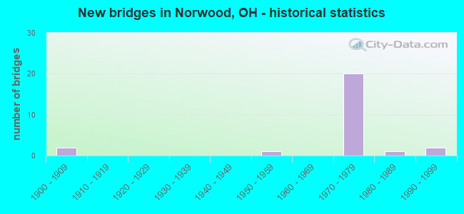
- New bridges - historical statistics
- 21900-1909
- 11950-1959
- 201970-1979
- 11980-1989
- 21990-1999


- Bridge Condition - Deck
- 13.3%Very good
- 40.0%Good
- 33.3%Satisfactory
- 13.3%Fair

- Bridge Condition - Superstructure
- 13.3%Very good
- 40.0%Good
- 33.3%Satisfactory
- 6.7%Fair
- 6.7%Serious

- Bridge Condition - Substructure
- 53.3%Good
- 33.3%Satisfactory
- 13.3%Fair

- Bridge Condition - Channel
- 33.3%Good
- 66.7%Satisfactory
Find on map >> Show street view
Structure Number: 3100855, Location: OVER SR562 (Lat: 39.164331, Lng: -84.454311), Route carried "on" structure: US 22, Year Built: 1972, Status: Open, Structure Length: 3.23m (10.60ft), Average Daily Traffic: 16,544 (year 2015), Truck Traffic: 6%, Average Future Daily Traffic: 22,963 (year 2035), Design Load: HS 20+Mod, Features Intersected: S562
Minimum Vertical Clearance: 30+ m (98+ ft), Kilometerpoint: 10.010, Lanes on structure: 4, Lanes under structure: 5, Base Highway Network: Yes, Owner: State Highway Agency, Approaching Roadway Width: 20.7m (67.9ft), Skew: 20 degrees, Material/Design: Steel continuous, Design/Construction: Stringer/Multi-beam, Number Of Spans In Main Unit: 2, Length of Maximum Span: 17.4m (57.1ft), Curb or Sidewalk Widths: Left: 3.0m (9.8ft), Right: 1.8m (5.9ft), Curb-To-Curb Width: 20.1m (65.9ft), Out-to-Out Width: 25.7m (84.3ft)
Condition: Deck: Good, Superstructure: Good, Substructure: Good, Operating Rating: 42.1 metric tons, Method Used To Determine Operating Rating: Load Factor (LF) rating reported by rating factor (RF) method using MS18 loading, Inventory Rating: 32.4 metric tons, Method Used To Determine Inventory Rating: Load Factor (LF) rating reported by rating factor (RF) method using MS18 loading, Structural Evaluation: Better than present minimum criteria, Deck Geometry: Better than present minimum criteria, Underclear: High priority of corrective action, Approach Roadway Alignment: Superior to present desirable criteria, Designated Inspection Frequency: Every 24 months, Inspection Date: June 2021, Deck Structure Type: Concrete Cast-file-Place, Wearing Surface/Protective System: Wearing Surface: Integral Concrete
Find on map >> Show street view
Structure Number: 3100863, Location: JUST W OF SR562 (Lat: 39.163919, Lng: -84.454489), Route carried "on" structure: US 22, Year Built: 1990, Status: Open, Structure Length: 3.11m (10.20ft), Average Daily Traffic: 16,544 (year 2015), Truck Traffic: 6%, Average Future Daily Traffic: 22,963 (year 2035), Design Load: HS 20+Mod, Features Intersected: CHESSIE SYSTEM RAILROAD
Minimum Vertical Clearance: 30+ m (98+ ft), Kilometerpoint: 9.962, Lanes on structure: 5, Base Highway Network: Yes, Owner: State Highway Agency, Approaching Roadway Width: 20.4m (66.9ft), Material/Design: Prestressed concrete continuous, Design/Construction: Box Beam or Girders - Multiple, Number Of Spans In Main Unit: 3, Length of Maximum Span: 16.2m (53.1ft), Curb or Sidewalk Widths: Left: 3.0m (9.8ft), Right: 1.8m (5.9ft), Curb-To-Curb Width: 20.1m (65.9ft), Out-to-Out Width: 25.7m (84.3ft)
Condition: Deck: Good, Superstructure: Good, Substructure: Good, Operating Rating: 90.7 metric tons, Method Used To Determine Operating Rating: Load Factor (LF) rating reported by rating factor (RF) method using MS18 loading, Inventory Rating: 55.1 metric tons, Method Used To Determine Inventory Rating: Load Factor (LF) rating reported by rating factor (RF) method using MS18 loading, Structural Evaluation: Better than present minimum criteria, Deck Geometry: Somewhat better than minimum adequacy, Underclear: High priority of corrective action, Approach Roadway Alignment: Equal to present desirable criteria, Designated Inspection Frequency: Every 24 months, Inspection Date: June 2021, Deck Structure Type: Concrete Cast-file-Place, Wearing Surface/Protective System: Wearing Surface: Bituminous
Find on map >> Show street view
Structure Number: 3113663, Location: OVER IR 71 (Lat: 39.152339, Lng: -84.443461), Route carried "on" structure: State highway 561, Year Built: 1972, Status: Open, Structure Length: 8.75m (28.71ft), Average Daily Traffic: 15,163 (year 2015), Truck Traffic: 4%, Average Future Daily Traffic: 21,046 (year 2035), Design Load: H 20, Features Intersected: I71
Minimum Vertical Clearance: 30+ m (98+ ft), Kilometerpoint: 5.053, Lanes on structure: 4, Lanes under structure: 8, Owner: State Highway Agency, Approaching Roadway Width: 12.8m (42.0ft), Skew: 2 degrees, Material/Design: Steel continuous, Design/Construction: Stringer/Multi-beam, Number Of Spans In Main Unit: 4, Length of Maximum Span: 25.3m (83.0ft), Curb or Sidewalk Widths: Left: 1.5m (4.9ft), Right: 1.5m (4.9ft), Curb-To-Curb Width: 14.6m (47.9ft), Out-to-Out Width: 18.4m (60.4ft)
Condition: Deck: Good, Superstructure: Good, Substructure: Good, Operating Rating: 42.1 metric tons, Method Used To Determine Operating Rating: Load and Resistance Factor Rating (LRFR) rating reported by rating factor(RF) method using HL-93 loadings, Inventory Rating: 32.4 metric tons, Method Used To Determine Inventory Rating: Load and Resistance Factor Rating (LRFR) rating reported by rating factor(RF) method using HL-93 loadings, Structural Evaluation: Better than present minimum criteria, Deck Geometry: High priority of replacement, Underclear: High priority of corrective action, Approach Roadway Alignment: Superior to present desirable criteria, Designated Inspection Frequency: Every 24 months, Inspection Date: August 2021, Deck Structure Type: Concrete Cast-file-Place, Wearing Surface/Protective System: Wearing Surface: Integral Concrete
Find on map >> Show street view
Structure Number: 3113914, Location: .3 MI E OF US 42 (Lat: 39.167739, Lng: -84.465639), Route carried "on" structure: State highway 562, Year Built: 1972, Status: Open, Structure Length: 42.82m (140.49ft), Average Daily Traffic: 58,705 (year 2015), Truck Traffic: 5%, Average Future Daily Traffic: 81,483 (year 2035), Design Load: HS 15, Features Intersected: ROSS AVENUE;CSRR, CR689
Minimum Vertical Clearance: 30+ m (98+ ft), Kilometerpoint: 2.366, Lanes on structure: 2, Lanes under structure: 6, Base Highway Network: Yes, Owner: State Highway Agency, Approaching Roadway Width: 9.8m (32.2ft), Skew: 10 degrees, Material/Design: Steel, Design/Construction: Girder and Floorbeam System, Number Of Spans In Main Unit: 13, Length of Maximum Span: 48.8m (160.1ft), Curb-To-Curb Width: 23.2m (76.1ft), Out-to-Out Width: 24.5m (80.4ft)
Condition: Deck: Satisfactory, Superstructure: Satisfactory, Substructure: Satisfactory, Operating Rating: 38.9 metric tons, Method Used To Determine Operating Rating: Load and Resistance Factor Rating (LRFR) rating reported by rating factor(RF) method using HL-93 loadings, Inventory Rating: 29.2 metric tons, Method Used To Determine Inventory Rating: Load and Resistance Factor Rating (LRFR) rating reported by rating factor(RF) method using HL-93 loadings, Structural Evaluation: Equal to present minimum criteria, Deck Geometry: Superior to present desirable criteria, Underclear: Somewhat better than minimum adequacy, Approach Roadway Alignment: Superior to present desirable criteria, Designated Inspection Frequency: Every 12 months, Critical Feature Inspection Frequency: Every 24 months, Inspection Date: November 2021, Critical Feature Inspection Date: September 2021, Deck Structure Type: Concrete Cast-file-Place, Wearing Surface/Protective System: Wearing Surface: Integral Concrete
Find on map >> Show street view
Structure Number: 3113949, Location: .3 MI W OF US 22 (Lat: 39.165950, Lng: -84.460000), Route carried "on" structure: City street SECTN, Year Built: 1972, Status: Open, Structure Length: 3.54m (11.61ft), Average Daily Traffic: 6,076 (year 2015), Truck Traffic: 5%, Average Future Daily Traffic: 81,483 (year 2035), Design Load: HS 20+Mod, Features Intersected: S562, Facility Carried by Structure: SECTION AVE
Minimum Vertical Clearance: 30+ m (98+ ft), Kilometerpoint: 32.187, Lanes on structure: 1, Lanes under structure: 4, Owner: State Highway Agency, Approaching Roadway Width: 5.5m (18.0ft), Skew: 31 degrees, Material/Design: Concrete continuous, Design/Construction: Slab, Number Of Spans In Main Unit: 3, Length of Maximum Span: 14.6m (47.9ft), Curb or Sidewalk Widths: Left: 1.6m (5.2ft), Right: 1.6m (5.2ft), Curb-To-Curb Width: 13.4m (44.0ft), Out-to-Out Width: 17.2m (56.4ft)
Condition: Deck: Satisfactory, Superstructure: Satisfactory, Substructure: Satisfactory, Operating Rating: 42.1 metric tons, Method Used To Determine Operating Rating: Load Factor (LF) rating reported by rating factor (RF) method using MS18 loading, Inventory Rating: 32.4 metric tons, Method Used To Determine Inventory Rating: Load Factor (LF) rating reported by rating factor (RF) method using MS18 loading, Structural Evaluation: Equal to present minimum criteria, Deck Geometry: Equal to present minimum criteria, Underclear: High priority of corrective action, Approach Roadway Alignment: Superior to present desirable criteria, Designated Inspection Frequency: Every 12 months, Inspection Date: September 2021, Deck Structure Type: Concrete Cast-file-Place, Wearing Surface/Protective System: Wearing Surface: Integral Concrete
Find on map >> Show street view
Structure Number: 3113981, Location: .2 MI E OF US 22 (Lat: 39.163969, Lng: -84.451350), Route carried "on" structure: City street WESLY, Year Built: 1970, Status: Open, Structure Length: 5.40m (17.72ft), Average Daily Traffic: 1,949 (year 2015), Truck Traffic: 5%, Average Future Daily Traffic: 68,780 (year 2035), Design Load: HS 20+Mod, Features Intersected: S562, Facility Carried by Structure: WESLEY AVE
Minimum Vertical Clearance: 30+ m (98+ ft), Kilometerpoint: 1.609, Lanes on structure: 4, Lanes under structure: 4, Owner: State Highway Agency, Approaching Roadway Width: 7.3m (24.0ft), Material/Design: Steel continuous, Design/Construction: Stringer/Multi-beam, Number Of Spans In Main Unit: 3, Length of Maximum Span: 20.1m (65.9ft), Curb or Sidewalk Widths: Left: 1.5m (4.9ft), Right: 0.6m (2.0ft), Curb-To-Curb Width: 15.9m (52.2ft), Out-to-Out Width: 18.7m (61.4ft)
Condition: Deck: Fair, Superstructure: Satisfactory, Substructure: Satisfactory, Operating Rating: 42.1 metric tons, Method Used To Determine Operating Rating: Load Factor (LF) rating reported by rating factor (RF) method using MS18 loading, Inventory Rating: 32.4 metric tons, Method Used To Determine Inventory Rating: Load Factor (LF) rating reported by rating factor (RF) method using MS18 loading, Structural Evaluation: Equal to present minimum criteria, Deck Geometry: Meets minimum limits, Underclear: High priority of corrective action, Approach Roadway Alignment: Superior to present desirable criteria, Designated Inspection Frequency: Every 12 months, Inspection Date: August 2021, Deck Structure Type: Concrete Cast-file-Place, Wearing Surface/Protective System: Wearing Surface: Monolithic Concrete
Find on map >> Show street view
Structure Number: 3114023, Location: .4 MI E OF US 22 (Lat: 39.163261, Lng: -84.446489), Route carried "on" structure: City street FORES, Year Built: 1970, Status: Open, Structure Length: 6.34m (20.80ft), Average Daily Traffic: 2,685 (year 2015), Truck Traffic: 5%, Average Future Daily Traffic: 86,651 (year 2035), Design Load: H 20, Features Intersected: S562
Minimum Vertical Clearance: 30+ m (98+ ft), Kilometerpoint: 160.918, Lanes on structure: 2, Lanes under structure: 5, Owner: State Highway Agency, Approaching Roadway Width: 7.3m (24.0ft), Material/Design: Steel continuous, Design/Construction: Stringer/Multi-beam, Number Of Spans In Main Unit: 4, Length of Maximum Span: 21.3m (69.9ft), Curb or Sidewalk Widths: Left: 1.5m (4.9ft), Right: 1.5m (4.9ft), Curb-To-Curb Width: 9.1m (29.9ft), Out-to-Out Width: 12.9m (42.3ft)
Condition: Deck: Satisfactory, Superstructure: Good, Substructure: Good, Operating Rating: 42.1 metric tons, Method Used To Determine Operating Rating: Load Factor (LF) rating reported by rating factor (RF) method using MS18 loading, Inventory Rating: 32.4 metric tons, Method Used To Determine Inventory Rating: Load Factor (LF) rating reported by rating factor (RF) method using MS18 loading, Structural Evaluation: Better than present minimum criteria, Deck Geometry: Meets minimum limits, Underclear: High priority of corrective action, Approach Roadway Alignment: Superior to present desirable criteria, Designated Inspection Frequency: Every 12 months, Inspection Date: August 2021, Deck Structure Type: Concrete Cast-file-Place, Wearing Surface/Protective System: Wearing Surface: Integral Concrete
Find on map >> Show street view
Structure Number: 3114082, Location: .6 MI E OF US 22 (Lat: 39.163781, Lng: -84.442689), Route carried "on" structure: City street BEECH, Year Built: 1970, Status: Open, Structure Length: 3.17m (10.40ft), Average Daily Traffic: 100 (year 1970), Truck Traffic: 10%, Average Future Daily Traffic: 86,651 (year 1990), Design Load: H 20, Features Intersected: S562
Minimum Vertical Clearance: 30+ m (98+ ft), Kilometerpoint: 160.918, Lanes on structure: 2, Lanes under structure: 4, Owner: State Highway Agency, Approaching Roadway Width: 7.9m (25.9ft), Skew: 3 degrees, Material/Design: Steel continuous, Design/Construction: Stringer/Multi-beam, Number Of Spans In Main Unit: 2, Length of Maximum Span: 15.2m (49.9ft), Curb or Sidewalk Widths: Left: 1.5m (4.9ft), Right: 1.5m (4.9ft), Curb-To-Curb Width: 9.1m (29.9ft), Out-to-Out Width: 12.9m (42.3ft)
Condition: Deck: Satisfactory, Superstructure: Satisfactory, Substructure: Good, Operating Rating: 42.1 metric tons, Method Used To Determine Operating Rating: Load Factor (LF) rating reported by rating factor (RF) method using MS18 loading, Inventory Rating: 32.4 metric tons, Method Used To Determine Inventory Rating: Load Factor (LF) rating reported by rating factor (RF) method using MS18 loading, Structural Evaluation: Equal to present minimum criteria, Deck Geometry: Better than present minimum criteria, Underclear: High priority of corrective action, Approach Roadway Alignment: Superior to present desirable criteria, Designated Inspection Frequency: Every 12 months, Inspection Date: August 2021, Deck Structure Type: Concrete Cast-file-Place, Wearing Surface/Protective System: Wearing Surface: Monolithic Concrete
Find on map >> Show street view
Structure Number: 3114783, Location: .4 MI S OF SR 561 (Lat: 39.148600, Lng: -84.448900), Route carried "on" structure: Interstate 71, Year Built: 1972, Status: Open, Structure Length: 0.76m (2.49ft), Average Daily Traffic: 132,212 (year 2017), Truck Traffic: 14%, Average Future Daily Traffic: 183,510 (year 2037), Design Load: HS 20+Mod, Features Intersected: HIRES LANE UNDER I-71
Minimum Vertical Clearance: 30+ m (98+ ft), Kilometerpoint: 10.589, Lanes on structure: 8, Lanes under structure: 1, Base Highway Network: Yes, Owner: State Highway Agency, Approaching Roadway Width: 18.3m (60.0ft), Skew: 10 degrees, Material/Design: Concrete, Design/Construction: Culvert, Number Of Spans In Main Unit: 1, Length of Maximum Span: 7.3m (24.0ft), Curb or Sidewalk Widths: Left: 1.5m (4.9ft), Right: 1.5m (4.9ft)
Condition: Culverts: Satisfactory, Operating Rating: 42.1 metric tons, Method Used To Determine Operating Rating: Load Factor (LF) rating reported by rating factor (RF) method using MS18 loading, Inventory Rating: 32.4 metric tons, Method Used To Determine Inventory Rating: Load Factor (LF) rating reported by rating factor (RF) method using MS18 loading, Structural Evaluation: Equal to present minimum criteria, Underclear: High priority of corrective action, Approach Roadway Alignment: Superior to present desirable criteria, Designated Inspection Frequency: Every 12 months, Inspection Date: April 2021
Find on map >> Show street view
Structure Number: 3114813, Location: .2 MI S OF SR 561 (Lat: 39.150031, Lng: -84.445711), Route carried "on" structure: City street SMITH, Year Built: 1972, Status: Open, Structure Length: 8.60m (28.22ft), Average Daily Traffic: 18,124 (year 2018), Truck Traffic: 7%, Average Future Daily Traffic: 159,992 (year 2038), Design Load: H 20, Features Intersected: I71
Minimum Vertical Clearance: 30+ m (98+ ft), Kilometerpoint: 3.219, Lanes on structure: 4, Lanes under structure: 8, Owner: State Highway Agency, Approaching Roadway Width: 12.8m (42.0ft), Skew: 1 degrees, Material/Design: Steel continuous, Design/Construction: Stringer/Multi-beam, Number Of Spans In Main Unit: 4, Length of Maximum Span: 24.4m (80.1ft), Curb or Sidewalk Widths: Left: 1.5m (4.9ft), Right: 1.5m (4.9ft), Curb-To-Curb Width: 14.6m (47.9ft), Out-to-Out Width: 18.4m (60.4ft)
Condition: Deck: Good, Superstructure: Good, Substructure: Good, Operating Rating: 42.1 metric tons, Method Used To Determine Operating Rating: Load and Resistance Factor Rating (LRFR) rating reported by rating factor(RF) method using HL-93 loadings, Inventory Rating: 32.4 metric tons, Method Used To Determine Inventory Rating: Load and Resistance Factor Rating (LRFR) rating reported by rating factor(RF) method using HL-93 loadings, Structural Evaluation: Better than present minimum criteria, Deck Geometry: High priority of replacement, Underclear: High priority of corrective action, Approach Roadway Alignment: Superior to present desirable criteria, Designated Inspection Frequency: Every 24 months, Inspection Date: April 2021, Deck Structure Type: Concrete Cast-file-Place, Wearing Surface/Protective System: Wearing Surface: Integral Concrete
Find on map >> Show street view
Structure Number: 3114902, Location: .4 MI N OF SR 561 (Lat: 39.156669, Lng: -84.439969), Route carried "on" structure: City street ROBTN, Year Built: 1972, Status: Open, Structure Length: 8.20m (26.90ft), Average Daily Traffic: 9,966 (year 2015), Truck Traffic: 5%, Average Future Daily Traffic: 192,961 (year 2035), Design Load: H 20, Features Intersected: I71, Facility Carried by Structure: ROBERTSON AVE
Minimum Vertical Clearance: 30+ m (98+ ft), Kilometerpoint: 80.467, Lanes on structure: 4, Lanes under structure: 8, Owner: State Highway Agency, Approaching Roadway Width: 12.8m (42.0ft), Skew: 1 degrees, Material/Design: Steel continuous, Design/Construction: Stringer/Multi-beam, Number Of Spans In Main Unit: 4, Length of Maximum Span: 25.3m (83.0ft), Curb or Sidewalk Widths: Left: 1.5m (4.9ft), Right: 1.5m (4.9ft), Curb-To-Curb Width: 14.6m (47.9ft), Out-to-Out Width: 18.4m (60.4ft)
Condition: Deck: Good, Superstructure: Serious, Substructure: Satisfactory, Operating Rating: 42.1 metric tons, Method Used To Determine Operating Rating: Allowable Stress (AS) rating reported by rating factor (RF) method using MS18 loading, Inventory Rating: 32.4 metric tons, Method Used To Determine Inventory Rating: Allowable Stress (AS) rating reported by rating factor (RF) method using MS18 loading, Structural Evaluation: High priority of corrective action, Deck Geometry: High priority of replacement, Underclear: High priority of corrective action, Approach Roadway Alignment: Superior to present desirable criteria, Designated Inspection Frequency: Every 12 months, Inspection Date: July 2021, Deck Structure Type: Concrete Cast-file-Place, Wearing Surface/Protective System: Wearing Surface: Integral Concrete
Find on map >> Show street view
Structure Number: 3160001, Location: 660 FT N OF SECTION RD (Lat: 39.198250, Lng: -84.447789), Route carried "on" structure: City street ELBRO, Year Built: 1900, Status: Open, Structure Length: 0.76m (2.49ft), Average Daily Traffic: 500 (year 2015), Truck Traffic: 5%, Average Future Daily Traffic: 694 (year 2035), Features Intersected: SECTION RD CREEK
Minimum Vertical Clearance: 30+ m (98+ ft), Kilometerpoint: 0.201, Lanes on structure: 2, Owner: City or Municipal Highway Agency, Approaching Roadway Width: 7.3m (24.0ft), Skew: 4 degrees, Material/Design: Concrete, Design/Construction: Frame, Number Of Spans In Main Unit: 1, Length of Maximum Span: 7.0m (23.0ft), Curb-To-Curb Width: 7.3m (24.0ft), Out-to-Out Width: 13.4m (44.0ft)
Condition: Deck: Very good, Superstructure: Very good, Substructure: Satisfactory, Channel: Satisfactory, Operating Rating: 40.8 metric tons, Method Used To Determine Operating Rating: Field evaluation and documented engineering judgment, Inventory Rating: 32.7 metric tons, Method Used To Determine Inventory Rating: Field evaluation and documented engineering judgment, Structural Evaluation: Equal to present minimum criteria, Deck Geometry: Meets minimum limits, Waterway Adequacy: Better than present minimum criteria, Approach Roadway Alignment: Equal to present minimum criteria, Designated Inspection Frequency: Every 12 months, Inspection Date: May 2021, Deck Structure Type: Concrete Cast-file-Place, Wearing Surface/Protective System: Wearing Surface: Bituminous
Find on map >> Show street view
Structure Number: 3160009, Location: 500 FT S OF DUCK CREEK RD (Lat: 39.160689, Lng: -84.438339), Route carried "on" structure: City street HARIS, Year Built: 1985, Status: Open, Structure Length: 1.23m (4.04ft), Average Daily Traffic: 200 (year 2020), Truck Traffic: 5%, Average Future Daily Traffic: 278 (year 2040), Design Load: HS 20+Mod, Features Intersected: DUCK CREEK, Facility Carried by Structure: HARRIS AVENUE
Minimum Vertical Clearance: 30+ m (98+ ft), Kilometerpoint: 0.259, Lanes on structure: 2, Owner: City or Municipal Highway Agency, Approaching Roadway Width: 7.3m (24.0ft), Skew: 4 degrees, Material/Design: Prestressed concrete, Design/Construction: Box Beam or Girders - Multiple, Number Of Spans In Main Unit: 1, Length of Maximum Span: 11.7m (38.4ft), Curb-To-Curb Width: 7.3m (24.0ft), Out-to-Out Width: 7.3m (24.0ft)
Condition: Deck: Good, Superstructure: Good, Substructure: Good, Channel: Good, Operating Rating: 51.8 metric tons, Method Used To Determine Operating Rating: Load and Resistance Factor Rating (LRFR) rating reported by rating factor(RF) method using HL-93 loadings, Inventory Rating: 42.1 metric tons, Method Used To Determine Inventory Rating: Load and Resistance Factor Rating (LRFR) rating reported by rating factor(RF) method using HL-93 loadings, Structural Evaluation: Better than present minimum criteria, Deck Geometry: Somewhat better than minimum adequacy, Waterway Adequacy: Equal to present desirable criteria, Approach Roadway Alignment: Equal to present minimum criteria, Designated Inspection Frequency: Every 24 months, Inspection Date: April 2021, Wearing Surface/Protective System: Wearing Surface: Bituminous
Find on map >> Show street view
Structure Number: 3160012, Location: 0.09 MI S OF NORWOOD AVE (Lat: 39.163111, Lng: -84.451389), Route carried "on" structure: City street WESLY, Year Built: 1992, Status: Open, Structure Length: 1.57m (5.15ft), Average Daily Traffic: 3,699 (year 2018), Truck Traffic: 5%, Average Future Daily Traffic: 5,135 (year 2038), Design Load: HS 20+Mod, Features Intersected: I&O RR, Facility Carried by Structure: WESLEY AVENUE
Minimum Vertical Clearance: 30+ m (98+ ft), Kilometerpoint: 0.370, Lanes on structure: 3, Owner: City or Municipal Highway Agency, Approaching Roadway Width: 13.1m (43.0ft), Skew: 1 degrees, Material/Design: Prestressed concrete, Design/Construction: Box Beam or Girders - Multiple, Number Of Spans In Main Unit: 1, Length of Maximum Span: 15.4m (50.5ft), Curb or Sidewalk Widths: Left: 0.2m (0.7ft), Right: 1.7m (5.6ft), Curb-To-Curb Width: 12.7m (41.7ft), Out-to-Out Width: 14.6m (47.9ft)
Condition: Deck: Very good, Superstructure: Very good, Substructure: Good, Operating Rating: 94.0 metric tons, Method Used To Determine Operating Rating: Load and Resistance Factor Rating (LRFR) rating reported by rating factor(RF) method using HL-93 loadings, Inventory Rating: 61.6 metric tons, Method Used To Determine Inventory Rating: Load and Resistance Factor Rating (LRFR) rating reported by rating factor(RF) method using HL-93 loadings, Structural Evaluation: Better than present minimum criteria, Deck Geometry: Meets minimum limits, Underclear: Better than present minimum criteria, Approach Roadway Alignment: Equal to present minimum criteria, Designated Inspection Frequency: Every 24 months, Inspection Date: April 2021, Deck Structure Type: Concrete Cast-file-Place, Wearing Surface/Protective System: Wearing Surface: Monolithic Concrete, Deck Protection: Epoxy Coated Reinforcing
Find on map >> Show street view
Structure Number: 3160013, Location: 80 FT. S OF DUCK CREEK RD (Lat: 39.161650, Lng: -84.437869), Route carried "on" structure: City street HARIS, Year Built: 1900, Year Reconstructed: 1985, Status: Open, Structure Length: 1.22m (4.00ft), Average Daily Traffic: 200 (year 2018), Truck Traffic: 10%, Average Future Daily Traffic: 2,800 (year 2038), Design Load: HS 20+Mod, Features Intersected: DUCK CREEK, Facility Carried by Structure: HARRIS AVENUE
Minimum Vertical Clearance: 30+ m (98+ ft), Kilometerpoint: 0.381, Lanes on structure: 2, Owner: City or Municipal Highway Agency, Approaching Roadway Width: 8.2m (26.9ft), Material/Design: Prestressed concrete, Design/Construction: Box Beam or Girders - Multiple, Number Of Spans In Main Unit: 1, Length of Maximum Span: 11.9m (39.0ft), Curb-To-Curb Width: 8.2m (26.9ft), Out-to-Out Width: 9.1m (29.9ft)
Condition: Deck: Satisfactory, Superstructure: Satisfactory, Substructure: Fair, Channel: Satisfactory, Operating Rating: 42.1 metric tons, Method Used To Determine Operating Rating: Load and Resistance Factor Rating (LRFR) rating reported by rating factor(RF) method using HL-93 loadings, Inventory Rating: 32.4 metric tons, Method Used To Determine Inventory Rating: Load and Resistance Factor Rating (LRFR) rating reported by rating factor(RF) method using HL-93 loadings, Structural Evaluation: Somewhat better than minimum adequacy, Deck Geometry: Somewhat better than minimum adequacy, Waterway Adequacy: Equal to present desirable criteria, Approach Roadway Alignment: Equal to present minimum criteria, Designated Inspection Frequency: Every 12 months, Inspection Date: April 2021, Deck Structure Type: Other, Wearing Surface/Protective System: Wearing Surface: Bituminous
Find on map >> Show street view
Structure Number: 316447, Location: At Foraker Avenue (Lat: 39.165581, Lng: -84.459969), Route carried "on" structure: City street SECTN, Year Built: 1957, Status: Open, Structure Length: 2.01m (6.59ft), Average Daily Traffic: 3,304 (year 2018), Truck Traffic: 5%, Average Future Daily Traffic: 4,586 (year 2038), Design Load: HS 20, Features Intersected: CSX RAILROAD, Facility Carried by Structure: SECTION AVENUE
Minimum Vertical Clearance: 30+ m (98+ ft), Kilometerpoint: 0.322, Lanes on structure: 2, Owner: City or Municipal Highway Agency, Approaching Roadway Width: 13.4m (44.0ft), Skew: 21 degrees, Material/Design: Prestressed concrete, Design/Construction: Stringer/Multi-beam, Number Of Spans In Main Unit: 1, Length of Maximum Span: 19.8m (65.0ft), Curb or Sidewalk Widths: Left: 1.5m (4.9ft), Right: 1.5m (4.9ft), Curb-To-Curb Width: 13.4m (44.0ft), Out-to-Out Width: 16.5m (54.1ft)
Condition: Deck: Fair, Superstructure: Fair, Substructure: Fair, Operating Rating: 97.2 metric tons, Method Used To Determine Operating Rating: Load Factor (LF) rating reported by rating factor (RF) method using MS18 loading, Inventory Rating: 48.6 metric tons, Method Used To Determine Inventory Rating: Load Factor (LF) rating reported by rating factor (RF) method using MS18 loading, Structural Evaluation: Somewhat better than minimum adequacy, Deck Geometry: Better than present minimum criteria, Underclear: Equal to present minimum criteria, Approach Roadway Alignment: Equal to present minimum criteria, Length Of Structure Improvement: 1.98m (6.50ft), Designated Inspection Frequency: Every 12 months, Inspection Date: April 2021, Roadway Improvement Cost: $50,000, Total Project Cost: $156,000, Deck Structure Type: Concrete Cast-file-Place, Wearing Surface/Protective System: Wearing Surface: Bituminous
Find on map >> Show street view
Structure Number: 3100855, Location: OVER SR562 (Lat: 39.164331, Lng: -84.454311), Route carried "under" structure: State highway 562, Year Built: 1972, Structure Length: 0. m, Average Daily Traffic: 58,705 (year 2015), Truck Traffic: 5%, Features Intersected: US22(S3,S561), Facility Carried by Structure: US22
Minimum Vertical Clearance: 4.62m (15.16ft), Kilometerpoint: 3.396, Lanes on structure: 4, Lanes under structure: 5, Material/Design: Steel continuous, Design/Construction: Stringer/Multi-beam, Length of Maximum Span: 17.4m (57.1ft)
Find on map >> Show street view
Structure Number: 3113663, Location: OVER IR 71 (Lat: 39.152339, Lng: -84.443461), Route carried "under" structure: Interstate 71, Year Built: 1972, Structure Length: 0. m, Average Daily Traffic: 115,268 (year 2015), Truck Traffic: 14%, Features Intersected: S561, Facility Carried by Structure: SR 561 WILLIAMS AV
Minimum Vertical Clearance: 5.15m (16.90ft), Kilometerpoint: 111.206, Lanes on structure: 4, Lanes under structure: 8, Material/Design: Steel continuous, Design/Construction: Stringer/Multi-beam, Length of Maximum Span: 25.3m (83.0ft)
Find on map >> Show street view
Structure Number: 3113914, Location: .3 MI E OF US 42 (Lat: 39.167739, Lng: -84.465639), Route carried "under" structure: County highway 689, Year Built: 1972, Structure Length: 0. m, Average Daily Traffic: 8,348 (year 2015), Truck Traffic: 3%, Features Intersected: S562, Facility Carried by Structure: SR 562
Minimum Vertical Clearance: 4.57m (14.99ft), Kilometerpoint: 0.016, Lanes on structure: 2, Lanes under structure: 6, Material/Design: Steel, Design/Construction: Girder and Floorbeam System, Length of Maximum Span: 48.8m (160.1ft)
Find on map >> Show street view
Structure Number: 3113949, Location: .3 MI W OF US 22 (Lat: 39.165950, Lng: -84.460000), Route carried "under" structure: State highway 562, Year Built: 1972, Structure Length: 0. m, Average Daily Traffic: 58,705 (year 2015), Truck Traffic: 5%, Features Intersected: SECTION AVENUE, Facility Carried by Structure: SECTION AVE
Minimum Vertical Clearance: 5.72m (18.77ft), Kilometerpoint: 2.881, Lanes on structure: 1, Lanes under structure: 4, Material/Design: Concrete continuous, Design/Construction: Slab, Length of Maximum Span: 14.6m (47.9ft)
Find on map >> Show street view
Structure Number: 3113981, Location: .2 MI E OF US 22 (Lat: 39.163969, Lng: -84.451350), Route carried "under" structure: State highway 562, Year Built: 1970, Structure Length: 0. m, Average Daily Traffic: 49,553 (year 2015), Truck Traffic: 5%, Features Intersected: WESLEY AVENUE, Facility Carried by Structure: WESLEY AVE
Minimum Vertical Clearance: 4.70m (15.42ft), Kilometerpoint: 3.653, Lanes on structure: 4, Lanes under structure: 4, Material/Design: Steel continuous, Design/Construction: Stringer/Multi-beam, Length of Maximum Span: 20.1m (65.9ft)
Find on map >> Show street view
Structure Number: 3114023, Location: .4 MI E OF US 22 (Lat: 39.163261, Lng: -84.446489), Route carried "under" structure: State highway 562, Year Built: 1970, Structure Length: 0. m, Average Daily Traffic: 62,429 (year 2015), Truck Traffic: 5%, Features Intersected: FOREST AVENUE, Facility Carried by Structure: FOREST AVE
Minimum Vertical Clearance: 5.13m (16.83ft), Kilometerpoint: 4.072, Lanes on structure: 2, Lanes under structure: 5, Material/Design: Steel continuous, Design/Construction: Stringer/Multi-beam, Length of Maximum Span: 21.3m (69.9ft)
Find on map >> Show street view
Structure Number: 3114082, Location: .6 MI E OF US 22 (Lat: 39.163781, Lng: -84.442689), Route carried "under" structure: State highway 562, Year Built: 1970, Structure Length: 0. m, Average Daily Traffic: 62,429 (year 2015), Truck Traffic: 5%, Features Intersected: BEECH STREET, Facility Carried by Structure: BEECH ST
Minimum Vertical Clearance: 4.58m (15.03ft), Kilometerpoint: 4.426, Lanes on structure: 2, Lanes under structure: 4, Material/Design: Steel continuous, Design/Construction: Stringer/Multi-beam, Length of Maximum Span: 15.2m (49.9ft)
Find on map >> Show street view
Structure Number: 3114783, Location: .4 MI S OF SR 561 (Lat: 39.148600, Lng: -84.448900), Route carried "under" structure: City street HIRES, Year Built: 1972, Structure Length: 0. m, Average Daily Traffic: 100 (year 1970), Truck Traffic: 99%, Features Intersected: I71, Facility Carried by Structure: IR 71
Minimum Vertical Clearance: 4.09m (13.42ft), Kilometerpoint: 0.016, Lanes on structure: 8, Lanes under structure: 1, Material/Design: Concrete, Design/Construction: Culvert, Length of Maximum Span: 7.3m (24.0ft)
Find on map >> Show street view
Structure Number: 3114813, Location: .2 MI S OF SR 561 (Lat: 39.150031, Lng: -84.445711), Route carried "under" structure: Interstate 71, Year Built: 1972, Structure Length: 0. m, Average Daily Traffic: 115,268 (year 2015), Truck Traffic: 14%, Features Intersected: SMITH ROAD, Facility Carried by Structure: SMITH RD
Minimum Vertical Clearance: 5.64m (18.50ft), Kilometerpoint: 10.863, Lanes on structure: 4, Lanes under structure: 8, Material/Design: Steel continuous, Design/Construction: Stringer/Multi-beam, Length of Maximum Span: 24.4m (80.1ft)
Find on map >> Show street view
Structure Number: 3114902, Location: .4 MI N OF SR 561 (Lat: 39.156669, Lng: -84.439969), Route carried "under" structure: Interstate 71, Year Built: 1972, Structure Length: 0. m, Average Daily Traffic: 139,021 (year 2015), Truck Traffic: 14%, Features Intersected: ROBERTSON AVENUE, Facility Carried by Structure: ROBERTSON AVE
Minimum Vertical Clearance: 4.47m (14.67ft), Kilometerpoint: 11.764, Lanes on structure: 4, Lanes under structure: 8, Material/Design: Steel continuous, Design/Construction: Stringer/Multi-beam, Length of Maximum Span: 25.3m (83.0ft)