Bridge Statistics for Northridge, Ohio (OH)
Condition, Traffic, Stress, Structural Evaluation, Project Costs
- National Bridge Inventory (NBI) Statistics
- 26Number of bridges
- 207ft / 63.0mTotal length
- 618,050Total average daily traffic
- 80,134Total average daily truck traffic
- National Bridge Inventory (NBI) Registered Bridges for Northridge
- No street view available for this location
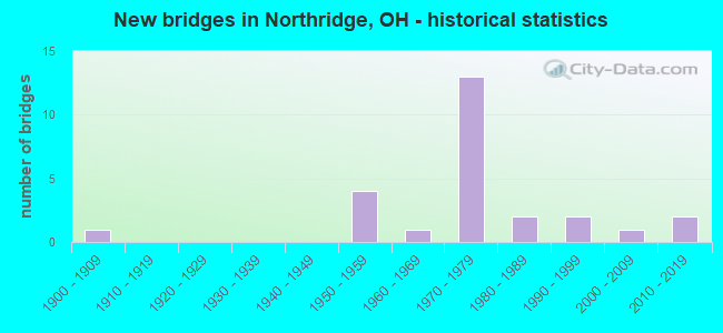
- New bridges - historical statistics
- 11900-1909
- 41950-1959
- 11960-1969
- 131970-1979
- 21980-1989
- 21990-1999
- 12000-2009
- 22010-2019

- Reconstructed bridges - Historical Statistics
- 12000-2009
- 12010-2019


- Bridge Condition - Deck
- 21.1%Excellent
- 15.8%Very good
- 42.1%Good
- 15.8%Satisfactory
- 5.3%Fair

- Bridge Condition - Superstructure
- 21.1%Excellent
- 15.8%Very good
- 57.9%Good
- 5.3%Satisfactory

- Bridge Condition - Substructure
- 15.8%Excellent
- 26.3%Very good
- 42.1%Good
- 15.8%Satisfactory

- Bridge Condition - Channel
- 25.0%Excellent
- 41.7%Very good
- 16.7%Good
- 8.3%Satisfactory
- 8.3%Fair
Find on map >> Show street view
Structure Number: 1133306, Location: .78 MI SOUTH OF DALLAS RO (Lat: 40.038061, Lng: -83.787219), Route carried "on" structure: County highway T0284, Year Built: 2001, Status: Open, Structure Length: 2.19m (7.19ft), Average Daily Traffic: 797 (year 2015), Truck Traffic: 8%, Average Future Daily Traffic: 1,106 (year 2035), Design Load: HS 20+Mod, Features Intersected: MOORES RUN, Facility Carried by Structure: MOORES RUN
Minimum Vertical Clearance: 30+ m (98+ ft), Kilometerpoint: 0.032, Lanes on structure: 2, Owner: County Highway Agency, Approaching Roadway Width: 8.5m (27.9ft), Skew: 4 degrees, Material/Design: Prestressed concrete, Design/Construction: Box Beam or Girders - Multiple, Number Of Spans In Main Unit: 1, Length of Maximum Span: 21.3m (69.9ft), Curb-To-Curb Width: 9.8m (32.2ft), Out-to-Out Width: 9.8m (32.2ft)
Condition: Deck: Very good, Superstructure: Very good, Substructure: Very good, Channel: Very good, Operating Rating: 97.2 metric tons, Method Used To Determine Operating Rating: Load Factor (LF) rating reported by rating factor (RF) method using MS18 loading, Inventory Rating: 38.9 metric tons, Method Used To Determine Inventory Rating: Load Factor (LF) rating reported by rating factor (RF) method using MS18 loading, Structural Evaluation: Equal to present desirable criteria, Deck Geometry: Equal to present minimum criteria, Waterway Adequacy: Superior to present desirable criteria, Approach Roadway Alignment: Superior to present desirable criteria, Designated Inspection Frequency: Every 24 months, Inspection Date: November 2021, Deck Structure Type: Concrete Cast-file-Place, Wearing Surface/Protective System: Wearing Surface: Bituminous, Membrane: Preformed Fabric, Deck Protection: Other Coated Reinforcing
Find on map >> Show street view
Structure Number: 120055, Location: 1.73MI.S. OF CHAMPAIGN CO (Lat: 40.009131, Lng: -83.703089), Route carried "on" structure: State highway 4, Year Built: 2011, Status: Open, Structure Length: 2.04m (6.69ft), Average Daily Traffic: 4,125 (year 2015), Truck Traffic: 15%, Average Future Daily Traffic: 5,726 (year 2035), Design Load: HL 93, Features Intersected: BRANCH BUCK CREEK
Minimum Vertical Clearance: 30+ m (98+ ft), Kilometerpoint: 37.208, Lanes on structure: 2, Base Highway Network: Yes (, Subroute: 1), Owner: State Highway Agency, Approaching Roadway Width: 9.6m (31.5ft), Skew: 2 degrees, Material/Design: Concrete continuous, Design/Construction: Slab, Number Of Spans In Main Unit: 3, Length of Maximum Span: 7.6m (24.9ft), Curb-To-Curb Width: 13.4m (44.0ft), Out-to-Out Width: 13.4m (44.0ft)
Condition: Deck: Excellent, Superstructure: Excellent, Substructure: Very good, Channel: Very good, Operating Rating: 84.2 metric tons, Method Used To Determine Operating Rating: Load Factor (LF) rating reported by rating factor (RF) method using MS18 loading, Inventory Rating: 51.8 metric tons, Method Used To Determine Inventory Rating: Load Factor (LF) rating reported by rating factor (RF) method using MS18 loading, Structural Evaluation: Equal to present desirable criteria, Deck Geometry: Better than present minimum criteria, Waterway Adequacy: Equal to present desirable criteria, Approach Roadway Alignment: Equal to present desirable criteria, Designated Inspection Frequency: Every 24 months, Inspection Date: January 2022, Deck Structure Type: Concrete Cast-file-Place, Wearing Surface/Protective System: Wearing Surface: Monolithic Concrete, Deck Protection: Epoxy Coated Reinforcing
Find on map >> Show street view
Structure Number: 1203304, Location: .71MI.N. OF JCT. SR-72 (Lat: 39.997669, Lng: -83.810981), Route carried "on" structure: US 68, Year Built: 1971, Status: Open, Structure Length: 2.07m (6.79ft), Average Daily Traffic: 4,953 (year 2015), Truck Traffic: 7%, Average Future Daily Traffic: 6,875 (year 2035), Design Load: HS 20, Features Intersected: MOORES RUN
Minimum Vertical Clearance: 30+ m (98+ ft), Kilometerpoint: 21.066, Lanes on structure: 2, Base Highway Network: Yes, Owner: State Highway Agency, Approaching Roadway Width: 13.4m (44.0ft), Material/Design: Concrete continuous, Design/Construction: Slab, Number Of Spans In Main Unit: 3, Length of Maximum Span: 7.6m (24.9ft), Curb-To-Curb Width: 12.3m (40.4ft), Out-to-Out Width: 13.5m (44.3ft)
Condition: Deck: Good, Superstructure: Good, Substructure: Good, Channel: Excellent, Operating Rating: 32.4 metric tons, Method Used To Determine Operating Rating: Load Factor (LF) rating reported by rating factor (RF) method using MS18 loading, Inventory Rating: 25.9 metric tons, Method Used To Determine Inventory Rating: Load Factor (LF) rating reported by rating factor (RF) method using MS18 loading, Structural Evaluation: Equal to present minimum criteria, Deck Geometry: Better than present minimum criteria, Waterway Adequacy: Better than present minimum criteria, Approach Roadway Alignment: Better than present minimum criteria, Designated Inspection Frequency: Every 24 months, Inspection Date: January 2022, Deck Structure Type: Concrete Cast-file-Place, Wearing Surface/Protective System: Wearing Surface: Integral Concrete
Find on map >> Show street view
Structure Number: 1203339, Location: .71MI.N. OF JCT. SR-72 (Lat: 39.997639, Lng: -83.810669), Route carried "on" structure: US 68, Year Built: 1971, Status: Open, Structure Length: 2.07m (6.79ft), Average Daily Traffic: 4,953 (year 2015), Truck Traffic: 7%, Average Future Daily Traffic: 6,875 (year 2035), Design Load: HS 20, Features Intersected: MOORES RUN
Minimum Vertical Clearance: 30+ m (98+ ft), Kilometerpoint: 21.066, Lanes on structure: 2, Base Highway Network: Yes, Owner: State Highway Agency, Approaching Roadway Width: 13.4m (44.0ft), Material/Design: Concrete continuous, Design/Construction: Slab, Number Of Spans In Main Unit: 3, Length of Maximum Span: 7.6m (24.9ft), Curb-To-Curb Width: 12.3m (40.4ft), Out-to-Out Width: 13.5m (44.3ft)
Condition: Deck: Good, Superstructure: Good, Substructure: Satisfactory, Channel: Very good, Operating Rating: 32.4 metric tons, Method Used To Determine Operating Rating: Load Factor (LF) rating reported by rating factor (RF) method using MS18 loading, Inventory Rating: 25.9 metric tons, Method Used To Determine Inventory Rating: Load Factor (LF) rating reported by rating factor (RF) method using MS18 loading, Structural Evaluation: Equal to present minimum criteria, Deck Geometry: Better than present minimum criteria, Waterway Adequacy: Better than present minimum criteria, Approach Roadway Alignment: Better than present minimum criteria, Designated Inspection Frequency: Every 12 months, Inspection Date: January 2022, Deck Structure Type: Concrete Cast-file-Place, Wearing Surface/Protective System: Wearing Surface: Integral Concrete
Find on map >> Show street view
Structure Number: 1203363, Location: 1.28MI N OF JCT SR334 (Lat: 40.006061, Lng: -83.810331), Route carried "on" structure: County highway C0300, Year Built: 1971, Status: Open, Structure Length: 7.38m (24.21ft), Average Daily Traffic: 1,307 (year 2016), Truck Traffic: 5%, Average Future Daily Traffic: 1,814 (year 2036), Design Load: HS 20, Features Intersected: USR 68, Facility Carried by Structure: TREMONT CITY RD.
Minimum Vertical Clearance: 30+ m (98+ ft), Kilometerpoint: 19.079, Lanes on structure: 2, Lanes under structure: 4, Owner: State Highway Agency, Approaching Roadway Width: 13.4m (44.0ft), Material/Design: Steel continuous, Design/Construction: Stringer/Multi-beam, Number Of Spans In Main Unit: 4, Length of Maximum Span: 21.3m (69.9ft), Curb-To-Curb Width: 13.4m (44.0ft), Out-to-Out Width: 14.0m (45.9ft)
Condition: Deck: Good, Superstructure: Good, Substructure: Very good, Operating Rating: 77.8 metric tons, Method Used To Determine Operating Rating: Load Factor (LF) rating reported by rating factor (RF) method using MS18 loading, Inventory Rating: 71.3 metric tons, Method Used To Determine Inventory Rating: Load Factor (LF) rating reported by rating factor (RF) method using MS18 loading, Structural Evaluation: Better than present minimum criteria, Deck Geometry: Equal to present desirable criteria, Underclear: Somewhat better than minimum adequacy, Approach Roadway Alignment: Equal to present desirable criteria, Designated Inspection Frequency: Every 24 months, Inspection Date: January 2022, Deck Structure Type: Concrete Cast-file-Place, Wearing Surface/Protective System: Wearing Surface: Integral Concrete
Find on map >> Show street view
Structure Number: 1203398, Location: JCT. CHAMPAIGN COUNTY (Lat: 40.027169, Lng: -83.804461), Route carried "on" structure: County highway 164, Year Built: 1971, Status: Open, Structure Length: 7.77m (25.49ft), Average Daily Traffic: 2,927 (year 2016), Average Future Daily Traffic: 4,063 (year 2036), Design Load: HS 20, Features Intersected: USR 68, Facility Carried by Structure: COUNTY LINE RD
Minimum Vertical Clearance: 30+ m (98+ ft), Kilometerpoint: 2.490, Lanes on structure: 2, Lanes under structure: 4, Owner: State Highway Agency, Approaching Roadway Width: 13.7m (44.9ft), Skew: 1 degrees, Material/Design: Steel continuous, Design/Construction: Stringer/Multi-beam, Number Of Spans In Main Unit: 4, Length of Maximum Span: 22.3m (73.2ft), Curb-To-Curb Width: 13.0m (42.7ft), Out-to-Out Width: 14.1m (46.3ft)
Condition: Deck: Satisfactory, Superstructure: Good, Substructure: Good, Operating Rating: 32.4 metric tons, Method Used To Determine Operating Rating: Load Factor (LF) rating reported by rating factor (RF) method using MS18 loading, Inventory Rating: 25.9 metric tons, Method Used To Determine Inventory Rating: Load Factor (LF) rating reported by rating factor (RF) method using MS18 loading, Structural Evaluation: Equal to present minimum criteria, Deck Geometry: Equal to present minimum criteria, Underclear: Somewhat better than minimum adequacy, Approach Roadway Alignment: Equal to present desirable criteria, Designated Inspection Frequency: Every 12 months, Inspection Date: January 2022, Deck Structure Type: Concrete Cast-file-Place, Wearing Surface/Protective System: Wearing Surface: Latex Concrete
Find on map >> Show street view
Structure Number: 1238752, Location: 1/4 MI WEST OF URBANA RD. (Lat: 40.026439, Lng: -83.792081), Route carried "on" structure: County highway C0164, Year Built: 1985, Year Reconstructed: 2017, Status: Open, Structure Length: 1.16m (3.81ft), Average Daily Traffic: 3,580 (year 1991), Truck Traffic: 8%, Average Future Daily Traffic: 4,969 (year 2011), Design Load: HL 93, Features Intersected: COUNTY LINE RD, Facility Carried by Structure: COUNTY RD NO 164
Minimum Vertical Clearance: 30+ m (98+ ft), Kilometerpoint: 3.605, Lanes on structure: 2, Owner: County Highway Agency, Approaching Roadway Width: 7.3m (24.0ft), Material/Design: Steel, Design/Construction: Stringer/Multi-beam, Number Of Spans In Main Unit: 1, Length of Maximum Span: 11.6m (38.1ft), Curb-To-Curb Width: 8.5m (27.9ft), Out-to-Out Width: 9.1m (29.9ft)
Condition: Deck: Excellent, Superstructure: Excellent, Substructure: Very good, Channel: Very good, Operating Rating: 55.1 metric tons, Method Used To Determine Operating Rating: Load and Resistance Factor Rating (LRFR) rating reported by rating factor(RF) method using HL-93 loadings, Inventory Rating: 42.1 metric tons, Method Used To Determine Inventory Rating: Load and Resistance Factor Rating (LRFR) rating reported by rating factor(RF) method using HL-93 loadings, Structural Evaluation: Equal to present desirable criteria, Deck Geometry: Meets minimum limits, Waterway Adequacy: Better than present minimum criteria, Approach Roadway Alignment: Equal to present desirable criteria, Length Of Structure Improvement: 1.19m (3.90ft), Designated Inspection Frequency: Every 24 months, Inspection Date: September 2021, Deck Structure Type: Corrugated Steel, Wearing Surface/Protective System: Wearing Surface: Bituminous, Deck Protection: Other
Find on map >> Show street view
Structure Number: 1239015, Location: 1/4 WEST SR 68 (Lat: 40.005269, Lng: -83.803550), Route carried "on" structure: County highway C0300, Year Built: 1900, Year Reconstructed: 2021, Status: Open, Structure Length: 1.28m (4.20ft), Average Daily Traffic: 1,275 (year 2015), Truck Traffic: 5%, Average Future Daily Traffic: 1,770 (year 2035), Design Load: HL 93, Features Intersected: TREMONT CITY OV MOORES R, Facility Carried by Structure: COUNTY RD NO 300
Minimum Vertical Clearance: 30+ m (98+ ft), Kilometerpoint: 2.672, Lanes on structure: 2, Owner: County Highway Agency, Approaching Roadway Width: 6.1m (20.0ft), Material/Design: Steel, Design/Construction: Stringer/Multi-beam, Number Of Spans In Main Unit: 1, Length of Maximum Span: 12.2m (40.0ft), Curb-To-Curb Width: 9.1m (29.9ft), Out-to-Out Width: 9.1m (29.9ft)
Condition: Deck: Excellent, Superstructure: Excellent, Substructure: Excellent, Channel: Excellent, Operating Rating: 57.0 metric tons, Method Used To Determine Operating Rating: Load and Resistance Factor Rating (LRFR) rating reported by rating factor(RF) method using HL-93 loadings, Inventory Rating: 44.1 metric tons, Method Used To Determine Inventory Rating: Load and Resistance Factor Rating (LRFR) rating reported by rating factor(RF) method using HL-93 loadings, Structural Evaluation: Superior to present desirable criteria, Deck Geometry: Somewhat better than minimum adequacy, Waterway Adequacy: Equal to present desirable criteria, Approach Roadway Alignment: Equal to present desirable criteria, Designated Inspection Frequency: Every 12 months, Inspection Date: July 2021, Deck Structure Type: Corrugated Steel, Wearing Surface/Protective System: Wearing Surface: Bituminous, Membrane: Preformed Fabric
Find on map >> Show street view
Structure Number: 1239201, Location: .25 MI. SO ST. RT 4 (Lat: 40.007981, Lng: -83.703131), Route carried "on" structure: County highway C0388, Year Built: 1998, Status: Open, Structure Length: 1.59m (5.22ft), Average Daily Traffic: 797 (year 2015), Truck Traffic: 8%, Average Future Daily Traffic: 1,106 (year 2035), Design Load: HS 20, Features Intersected: OLD MECHBRG / BR BUCK CR, Facility Carried by Structure: C-388
Minimum Vertical Clearance: 30+ m (98+ ft), Kilometerpoint: 3.331, Lanes on structure: 2, Owner: County Highway Agency, Approaching Roadway Width: 7.9m (25.9ft), Skew: 4 degrees, Material/Design: Steel, Design/Construction: Stringer/Multi-beam, Number Of Spans In Main Unit: 1, Length of Maximum Span: 14.6m (47.9ft), Curb-To-Curb Width: 7.9m (25.9ft), Out-to-Out Width: 8.5m (27.9ft)
Condition: Deck: Very good, Superstructure: Very good, Substructure: Excellent, Channel: Very good, Operating Rating: 81.0 metric tons, Method Used To Determine Operating Rating: Allowable Stress (AS) rating reported by rating factor (RF) method using MS18 loading, Inventory Rating: 55.1 metric tons, Method Used To Determine Inventory Rating: Allowable Stress (AS) rating reported by rating factor (RF) method using MS18 loading, Structural Evaluation: Equal to present desirable criteria, Deck Geometry: Somewhat better than minimum adequacy, Waterway Adequacy: Superior to present desirable criteria, Approach Roadway Alignment: Equal to present minimum criteria, Designated Inspection Frequency: Every 24 months, Inspection Date: September 2021, Deck Structure Type: Corrugated Steel, Wearing Surface/Protective System: Wearing Surface: Bituminous, Membrane: Preformed Fabric
Find on map >> Show street view
Structure Number: 1239295, Location: 500 FT E ST RT 4 (Lat: 39.992861, Lng: -83.726989), Route carried "on" structure: County highway C0350, Year Built: 1993, Status: Open, Structure Length: 0.98m (3.22ft), Average Daily Traffic: 2,875 (year 2015), Truck Traffic: 2%, Average Future Daily Traffic: 3,991 (year 2035), Features Intersected: MOOREFIELD RD O BR BUCK, Facility Carried by Structure: C-350
Minimum Vertical Clearance: 30+ m (98+ ft), Kilometerpoint: 6.341, Lanes on structure: 2, Owner: County Highway Agency, Approaching Roadway Width: 9.8m (32.2ft), Material/Design: Concrete, Design/Construction: Frame, Number Of Spans In Main Unit: 1, Length of Maximum Span: 7.9m (25.9ft), Curb-To-Curb Width: 9.8m (32.2ft), Out-to-Out Width: 9.8m (32.2ft)
Condition: Deck: Good, Superstructure: Good, Substructure: Good, Channel: Good, Operating Rating: 40.8 metric tons, Method Used To Determine Operating Rating: Field evaluation and documented engineering judgment, Inventory Rating: 32.7 metric tons, Method Used To Determine Inventory Rating: Field evaluation and documented engineering judgment, Structural Evaluation: Better than present minimum criteria, Deck Geometry: Meets minimum limits, Waterway Adequacy: Superior to present desirable criteria, Approach Roadway Alignment: Superior to present desirable criteria, Designated Inspection Frequency: Every 24 months, Inspection Date: September 2021, Deck Structure Type: Concrete Cast-file-Place, Wearing Surface/Protective System: Wearing Surface: Bituminous
Find on map >> Show street view
Structure Number: 1239504, Location: 100 FT E OLD MECHANICSBUR (Lat: 39.992050, Lng: -83.714900), Route carried "on" structure: County highway C0350, Year Built: 2016, Status: Open, Structure Length: 3.20m (10.50ft), Average Daily Traffic: 1,610 (year 1999), Truck Traffic: 1%, Average Future Daily Traffic: 1,932 (year 2019), Design Load: HL 93, Features Intersected: MOOREFIELD RD & BUCK CK, Facility Carried by Structure: Moorefield Road
Minimum Vertical Clearance: 30+ m (98+ ft), Kilometerpoint: 7.387, Lanes on structure: 2, Owner: County Highway Agency, Approaching Roadway Width: 9.1m (29.9ft), Material/Design: Prestressed concrete, Design/Construction: Stringer/Multi-beam, Number Of Spans In Main Unit: 1, Length of Maximum Span: 32.0m (105.0ft), Curb-To-Curb Width: 9.1m (29.9ft), Out-to-Out Width: 9.1m (29.9ft)
Condition: Deck: Excellent, Superstructure: Excellent, Substructure: Excellent, Channel: Excellent, Operating Rating: 58.3 metric tons, Method Used To Determine Operating Rating: Load and Resistance Factor Rating (LRFR) rating reported by rating factor(RF) method using HL-93 loadings, Inventory Rating: 42.1 metric tons, Method Used To Determine Inventory Rating: Load and Resistance Factor Rating (LRFR) rating reported by rating factor(RF) method using HL-93 loadings, Structural Evaluation: Superior to present desirable criteria, Deck Geometry: Somewhat better than minimum adequacy, Waterway Adequacy: Superior to present desirable criteria, Approach Roadway Alignment: Superior to present desirable criteria, Length Of Structure Improvement: 3.14m (10.30ft), Designated Inspection Frequency: Every 24 months, Inspection Date: September 2021, Deck Structure Type: Concrete Cast-file-Place, Wearing Surface/Protective System: Membrane: Epoxy
Find on map >> Show street view
Structure Number: 1239708, Location: .36 MI. N. OF JCT. SR.334 (Lat: 39.990511, Lng: -83.805139), Route carried "on" structure: County highway C0068, Year Built: 1965, Status: Open, Structure Length: 2.07m (6.79ft), Average Daily Traffic: 8,028 (year 2015), Truck Traffic: 5%, Average Future Daily Traffic: 11,143 (year 2035), Design Load: HS 20, Features Intersected: URBANA RD. OV KENTON CK, Facility Carried by Structure: URBANA RD.
Minimum Vertical Clearance: 30+ m (98+ ft), Kilometerpoint: 0.570, Lanes on structure: 4, Owner: County Highway Agency, Approaching Roadway Width: 27.4m (89.9ft), Material/Design: Concrete continuous, Design/Construction: Slab, Number Of Spans In Main Unit: 3, Length of Maximum Span: 7.6m (24.9ft), Curb-To-Curb Width: 27.4m (89.9ft), Out-to-Out Width: 27.4m (89.9ft)
Condition: Deck: Satisfactory, Superstructure: Good, Substructure: Good, Channel: Good, Operating Rating: 45.4 metric tons, Method Used To Determine Operating Rating: Load Factor (LF) rating reported by rating factor (RF) method using MS18 loading, Inventory Rating: 29.2 metric tons, Method Used To Determine Inventory Rating: Load Factor (LF) rating reported by rating factor (RF) method using MS18 loading, Structural Evaluation: Better than present minimum criteria, Deck Geometry: Superior to present desirable criteria, Waterway Adequacy: Better than present minimum criteria, Approach Roadway Alignment: Better than present minimum criteria, Designated Inspection Frequency: Every 12 months, Inspection Date: September 2021, Deck Structure Type: Concrete Cast-file-Place, Wearing Surface/Protective System: Wearing Surface: Bituminous
Find on map >> Show street view
Structure Number: 5708761, Location: 2.08MI N OF JCT SR48 (Lat: 39.794589, Lng: -84.187889), Route carried "on" structure: Interstate 75, Year Built: 1959, Status: Open, Structure Length: 3.66m (12.01ft), Average Daily Traffic: 112,195 (year 2015), Truck Traffic: 14%, Average Future Daily Traffic: 155,727 (year 2035), Design Load: HS 20, Features Intersected: T1229(NEVA DRIVE)
Minimum Vertical Clearance: 30+ m (98+ ft), Kilometerpoint: 25.009, Lanes on structure: 6, Lanes under structure: 2, Base Highway Network: Yes, Owner: State Highway Agency, Approaching Roadway Width: 34.1m (111.9ft), Skew: 30 degrees, Material/Design: Steel continuous, Design/Construction: Stringer/Multi-beam, Number Of Spans In Main Unit: 3, Length of Maximum Span: 13.7m (44.9ft), Curb-To-Curb Width: 34.1m (111.9ft), Out-to-Out Width: 34.8m (114.2ft)
Condition: Deck: Good, Superstructure: Good, Substructure: Good, Operating Rating: 55.1 metric tons, Method Used To Determine Operating Rating: Load and Resistance Factor Rating (LRFR) rating reported by rating factor(RF) method using HL-93 loadings, Inventory Rating: 42.1 metric tons, Method Used To Determine Inventory Rating: Load and Resistance Factor Rating (LRFR) rating reported by rating factor(RF) method using HL-93 loadings, Structural Evaluation: Better than present minimum criteria, Deck Geometry: Superior to present desirable criteria, Underclear: Meets minimum limits, Approach Roadway Alignment: Equal to present desirable criteria, Designated Inspection Frequency: Every 24 months, Inspection Date: August 2021, Deck Structure Type: Concrete Cast-file-Place, Wearing Surface/Protective System: Wearing Surface: Integral Concrete
Find on map >> Show street view
Structure Number: 5708796, Location: 2.36MI N OF JCT SR48 (Lat: 39.798411, Lng: -84.189850), Route carried "on" structure: Interstate 75, Year Built: 1959, Status: Open, Structure Length: 5.58m (18.31ft), Average Daily Traffic: 103,168 (year 2015), Truck Traffic: 14%, Average Future Daily Traffic: 143,197 (year 2035), Design Load: HS 20, Features Intersected: C18(WAGONER FORD ROAD)
Minimum Vertical Clearance: 30+ m (98+ ft), Kilometerpoint: 25.460, Lanes on structure: 6, Lanes under structure: 4, Base Highway Network: Yes, Owner: State Highway Agency, Approaching Roadway Width: 34.1m (111.9ft), Skew: 32 degrees, Material/Design: Steel continuous, Design/Construction: Stringer/Multi-beam, Number Of Spans In Main Unit: 4, Length of Maximum Span: 15.2m (49.9ft), Curb-To-Curb Width: 34.1m (111.9ft), Out-to-Out Width: 34.8m (114.2ft)
Condition: Deck: Satisfactory, Superstructure: Good, Substructure: Satisfactory, Operating Rating: 51.8 metric tons, Method Used To Determine Operating Rating: Load and Resistance Factor Rating (LRFR) rating reported by rating factor(RF) method using HL-93 loadings, Inventory Rating: 38.9 metric tons, Method Used To Determine Inventory Rating: Load and Resistance Factor Rating (LRFR) rating reported by rating factor(RF) method using HL-93 loadings, Structural Evaluation: Equal to present minimum criteria, Deck Geometry: Superior to present desirable criteria, Underclear: Equal to present minimum criteria, Approach Roadway Alignment: Equal to present desirable criteria, Designated Inspection Frequency: Every 12 months, Inspection Date: August 2021, Deck Structure Type: Concrete Cast-file-Place, Wearing Surface/Protective System: Wearing Surface: Integral Concrete
Find on map >> Show street view
Structure Number: 5708826, Location: 2.9MI N OF JCT SR48 (Lat: 39.806150, Lng: -84.188931), Route carried "on" structure: Interstate 75, Year Built: 1971, Status: Open, Structure Length: 3.23m (10.60ft), Average Daily Traffic: 106,842 (year 2015), Truck Traffic: 14%, Average Future Daily Traffic: 148,297 (year 2035), Design Load: HS 20+Mod, Features Intersected: T1259(KEENAN AVENUE)
Minimum Vertical Clearance: 30+ m (98+ ft), Kilometerpoint: 26.329, Lanes on structure: 6, Lanes under structure: 2, Base Highway Network: Yes, Owner: State Highway Agency, Approaching Roadway Width: 11.0m (36.1ft), Skew: 30 degrees, Material/Design: Concrete continuous, Design/Construction: Slab, Number Of Spans In Main Unit: 3, Length of Maximum Span: 12.2m (40.0ft), Curb-To-Curb Width: 34.1m (111.9ft), Out-to-Out Width: 36.4m (119.4ft)
Condition: Deck: Good, Superstructure: Good, Substructure: Satisfactory, Operating Rating: 48.6 metric tons, Method Used To Determine Operating Rating: Load Factor (LF) rating reported by rating factor (RF) method using MS18 loading, Inventory Rating: 29.2 metric tons, Method Used To Determine Inventory Rating: Load Factor (LF) rating reported by rating factor (RF) method using MS18 loading, Structural Evaluation: Equal to present minimum criteria, Deck Geometry: Superior to present desirable criteria, Underclear: Somewhat better than minimum adequacy, Approach Roadway Alignment: Equal to present desirable criteria, Designated Inspection Frequency: Every 12 months, Inspection Date: July 2021, Deck Structure Type: Concrete Cast-file-Place, Wearing Surface/Protective System: Wearing Surface: Latex Concrete
Find on map >> Show street view
Structure Number: 570885, Location: 3.37MI N OF JCT SR48 (Lat: 39.813019, Lng: -84.189531), Route carried "on" structure: County highway C0130, Year Built: 1971, Status: Open, Structure Length: 8.84m (29.00ft), Average Daily Traffic: 959 (year 2015), Truck Traffic: 5%, Average Future Daily Traffic: 148,297 (year 2035), Design Load: H 15, Features Intersected: PAYNE AVE I75 WADSWRH RD, Facility Carried by Structure: TIMBER LANE (C130)
Minimum Vertical Clearance: 30+ m (98+ ft), Kilometerpoint: 0.756, Lanes on structure: 2, Lanes under structure: 10, Owner: State Highway Agency, Approaching Roadway Width: 11.6m (38.1ft), Material/Design: Steel continuous, Design/Construction: Stringer/Multi-beam, Number Of Spans In Main Unit: 6, Length of Maximum Span: 18.3m (60.0ft), Curb-To-Curb Width: 11.0m (36.1ft), Out-to-Out Width: 12.3m (40.4ft)
Condition: Deck: Fair, Superstructure: Satisfactory, Substructure: Good, Operating Rating: 45.4 metric tons, Method Used To Determine Operating Rating: Load Factor (LF) rating reported by rating factor (RF) method using MS18 loading, Inventory Rating: 29.2 metric tons, Method Used To Determine Inventory Rating: Load Factor (LF) rating reported by rating factor (RF) method using MS18 loading, Structural Evaluation: Equal to present minimum criteria, Deck Geometry: Better than present minimum criteria, Underclear: Meets minimum limits, Approach Roadway Alignment: Equal to present desirable criteria, Designated Inspection Frequency: Every 12 months, Inspection Date: July 2021, Deck Structure Type: Concrete Cast-file-Place, Wearing Surface/Protective System: Wearing Surface: Integral Concrete
Find on map >> Show street view
Structure Number: 5708885, Location: 3.15MI S OF JCT IR70 (Lat: 39.819819, Lng: -84.189611), Route carried "on" structure: County highway C0074, Year Built: 1971, Year Reconstructed: 2011, Status: Open, Structure Length: 6.25m (20.51ft), Average Daily Traffic: 20,389 (year 2015), Truck Traffic: 5%, Average Future Daily Traffic: 131,577 (year 2035), Design Load: HS 20+Mod, Features Intersected: I75, Facility Carried by Structure: NEEDMORE RD (C74)
Minimum Vertical Clearance: 30+ m (98+ ft), Kilometerpoint: 0.000, Lanes on structure: 4, Lanes under structure: 6, Base Highway Network: Yes, Owner: State Highway Agency, Approaching Roadway Width: 21.3m (69.9ft), Material/Design: Steel continuous, Design/Construction: Stringer/Multi-beam, Number Of Spans In Main Unit: 4, Length of Maximum Span: 17.4m (57.1ft), Curb-To-Curb Width: 22.6m (74.1ft), Out-to-Out Width: 23.8m (78.1ft)
Condition: Deck: Good, Superstructure: Good, Substructure: Very good, Operating Rating: 64.8 metric tons, Method Used To Determine Operating Rating: Allowable Stress (AS) rating reported by rating factor (RF) method using MS18 loading, Inventory Rating: 38.9 metric tons, Method Used To Determine Inventory Rating: Allowable Stress (AS) rating reported by rating factor (RF) method using MS18 loading, Structural Evaluation: Better than present minimum criteria, Deck Geometry: Superior to present desirable criteria, Underclear: High priority of corrective action, Approach Roadway Alignment: Equal to present desirable criteria, Designated Inspection Frequency: Every 24 months, Inspection Date: July 2021, Deck Structure Type: Concrete Cast-file-Place, Wearing Surface/Protective System: Wearing Surface: Monolithic Concrete, Deck Protection: Epoxy Coated Reinforcing
Find on map >> Show street view
Structure Number: 5736064, Location: 875 FT E N DIXIE DR (Lat: 39.802789, Lng: -84.190700), Route carried "on" structure: County highway T1247, Year Built: 1970, Status: Open, Structure Length: 0.79m (2.59ft), Average Daily Traffic: 1,295 (year 2015), Truck Traffic: 5%, Average Future Daily Traffic: 1,797 (year 2035), Design Load: HS 20, Features Intersected: STREAM
Minimum Vertical Clearance: 30+ m (98+ ft), Kilometerpoint: 0.402, Lanes on structure: 2, Owner: County Highway Agency, Approaching Roadway Width: 7.3m (24.0ft), Skew: 4 degrees, Material/Design: Concrete, Design/Construction: Slab, Number Of Spans In Main Unit: 1, Length of Maximum Span: 6.4m (21.0ft), Curb-To-Curb Width: 9.1m (29.9ft), Out-to-Out Width: 9.1m (29.9ft)
Condition: Deck: Good, Superstructure: Good, Substructure: Good, Channel: Fair, Operating Rating: 66.1 metric tons, Method Used To Determine Operating Rating: Load Factor (LF) rating reported by rating factor (RF) method using MS18 loading, Inventory Rating: 39.5 metric tons, Method Used To Determine Inventory Rating: Load Factor (LF) rating reported by rating factor (RF) method using MS18 loading, Structural Evaluation: Better than present minimum criteria, Deck Geometry: Somewhat better than minimum adequacy, Waterway Adequacy: Somewhat better than minimum adequacy, Approach Roadway Alignment: Equal to present desirable criteria, Designated Inspection Frequency: Every 24 months, Inspection Date: August 2021, Deck Structure Type: Concrete Cast-file-Place, Wearing Surface/Protective System: Wearing Surface: Bituminous
Find on map >> Show street view
Structure Number: 573611, Location: AT I75 (DEAD END) (Lat: 39.803681, Lng: -84.188500), Route carried "on" structure: County highway T065A, Year Built: 1984, Status: Open, Structure Length: 0.82m (2.69ft), Average Daily Traffic: 341 (year 2013), Truck Traffic: 5%, Average Future Daily Traffic: 473 (year 2033), Design Load: HS 20+Mod, Features Intersected: Creek
Minimum Vertical Clearance: 30+ m (98+ ft), Kilometerpoint: 0.563, Lanes on structure: 2, Owner: County Highway Agency, Approaching Roadway Width: 7.9m (25.9ft), Skew: 3 degrees, Material/Design: Concrete, Design/Construction: Slab, Number Of Spans In Main Unit: 1, Length of Maximum Span: 7.6m (24.9ft), Curb-To-Curb Width: 8.2m (26.9ft), Out-to-Out Width: 8.5m (27.9ft)
Condition: Deck: Very good, Superstructure: Very good, Substructure: Good, Channel: Satisfactory, Operating Rating: 97.2 metric tons, Method Used To Determine Operating Rating: Load Factor (LF) rating reported by rating factor (RF) method using MS18 loading, Inventory Rating: 77.8 metric tons, Method Used To Determine Inventory Rating: Load Factor (LF) rating reported by rating factor (RF) method using MS18 loading, Structural Evaluation: Better than present minimum criteria, Deck Geometry: Somewhat better than minimum adequacy, Waterway Adequacy: Equal to present desirable criteria, Approach Roadway Alignment: Equal to present desirable criteria, Designated Inspection Frequency: Every 24 months, Inspection Date: August 2021, Deck Structure Type: Concrete Cast-file-Place, Wearing Surface/Protective System: Wearing Surface: Bituminous
Find on map >> Show street view
Structure Number: 1203363, Location: 1.28MI N OF JCT SR334 (Lat: 40.006061, Lng: -83.810331), Route carried "under" structure: US 68, Year Built: 1971, Structure Length: 0. m, Average Daily Traffic: 10,332 (year 2016), Truck Traffic: 12%, Features Intersected: CR300 TREM CITY RD, Facility Carried by Structure: TREMONT CITY RD.
Minimum Vertical Clearance: 4.52m (14.83ft), Kilometerpoint: 22.000, Lanes on structure: 2, Lanes under structure: 4, Material/Design: Steel continuous, Design/Construction: Stringer/Multi-beam, Length of Maximum Span: 21.3m (69.9ft)
Find on map >> Show street view
Structure Number: 1203398, Location: JCT. CHAMPAIGN COUNTY (Lat: 40.027169, Lng: -83.804461), Route carried "under" structure: US 68, Year Built: 1971, Structure Length: 0. m, Average Daily Traffic: 10,332 (year 2016), Truck Traffic: 12%, Features Intersected: TR-164 COUNTY LINE RD, Facility Carried by Structure: COUNTY LINE RD
Minimum Vertical Clearance: 4.70m (15.42ft), Kilometerpoint: 24.398, Lanes on structure: 2, Lanes under structure: 4, Material/Design: Steel continuous, Design/Construction: Stringer/Multi-beam, Length of Maximum Span: 22.3m (73.2ft)
Find on map >> Show street view
Structure Number: 5708761, Location: 2.08MI N OF JCT SR48 (Lat: 39.794589, Lng: -84.187889), Route carried "under" structure: City street 1229, Year Built: 1959, Structure Length: 0. m, Average Daily Traffic: 1,949 (year 2015), Truck Traffic: 5%, Features Intersected: I75, Facility Carried by Structure: IR75
Minimum Vertical Clearance: 4.50m (14.76ft), Kilometerpoint: 1.287, Lanes on structure: 6, Lanes under structure: 2, Material/Design: Steel continuous, Design/Construction: Stringer/Multi-beam, Length of Maximum Span: 13.7m (44.9ft)
Find on map >> Show street view
Structure Number: 5708796, Location: 2.36MI N OF JCT SR48 (Lat: 39.798411, Lng: -84.189850), Route carried "under" structure: County highway 218, Year Built: 1959, Structure Length: 0. m, Average Daily Traffic: 9,255 (year 2015), Truck Traffic: 7%, Features Intersected: I75, Facility Carried by Structure: IR75
Minimum Vertical Clearance: 4.67m (15.32ft), Kilometerpoint: 0.322, Lanes on structure: 6, Lanes under structure: 4, Material/Design: Steel continuous, Design/Construction: Stringer/Multi-beam, Length of Maximum Span: 15.2m (49.9ft)
Find on map >> Show street view
Structure Number: 5708826, Location: 2.9MI N OF JCT SR48 (Lat: 39.806150, Lng: -84.188931), Route carried "under" structure: City street 1259, Year Built: 1971, Structure Length: 0. m, Average Daily Traffic: 2,128 (year 2015), Truck Traffic: 5%, Features Intersected: I75, Facility Carried by Structure: IR75
Minimum Vertical Clearance: 4.40m (14.44ft), Kilometerpoint: 0.805, Lanes on structure: 6, Lanes under structure: 2, Material/Design: Concrete continuous, Design/Construction: Slab, Length of Maximum Span: 12.2m (40.0ft)
Find on map >> Show street view
Structure Number: 570885, Location: 3.37MI N OF JCT SR48 (Lat: 39.813019, Lng: -84.189531), Route carried "under" structure: Interstate 75, Year Built: 1971, Structure Length: 0. m, Average Daily Traffic: 106,842 (year 2015), Truck Traffic: 14%, Features Intersected: C130(TIMBER LANE), Facility Carried by Structure: TIMBER LANE (C130)
Minimum Vertical Clearance: 4.78m (15.68ft), Kilometerpoint: 27.085, Lanes on structure: 2, Lanes under structure: 10, Material/Design: Steel continuous, Design/Construction: Stringer/Multi-beam, Length of Maximum Span: 18.3m (60.0ft)
Find on map >> Show street view
Structure Number: 5708885, Location: 3.15MI S OF JCT IR70 (Lat: 39.819819, Lng: -84.189611), Route carried "under" structure: Interstate 75, Year Built: 1971, Structure Length: 0. m, Average Daily Traffic: 94,796 (year 2015), Truck Traffic: 14%, Features Intersected: C74(NEEDMORE ROAD), Facility Carried by Structure: NEEDMORE RD (C74)
Minimum Vertical Clearance: 4.47m (14.67ft), Kilometerpoint: 27.826, Lanes on structure: 4, Lanes under structure: 6, Material/Design: Steel continuous, Design/Construction: Stringer/Multi-beam, Length of Maximum Span: 17.4m (57.1ft)