Bridge Statistics for Newburyport, Massachusetts (MA)
Condition, Traffic, Stress, Structural Evaluation, Project Costs
- National Bridge Inventory (NBI) Statistics
- 14Number of bridges
- 282ft / 86.4mTotal length
- $131,536,000Total costs
- 246,793Total average daily traffic
- 7,731Total average daily truck traffic
- National Bridge Inventory (NBI) Registered Bridges for Newburyport
- No street view available for this location
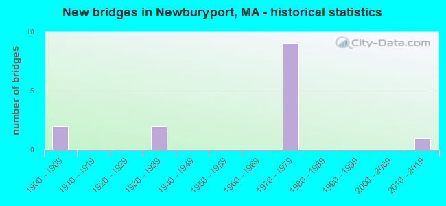
- New bridges - historical statistics
- 21900-1909
- 21930-1939
- 91970-1979
- 12010-2019


- Bridge Condition - Deck
- 22.2%Good
- 33.3%Satisfactory
- 44.4%Fair

- Bridge Condition - Superstructure
- 10.0%Very good
- 10.0%Good
- 30.0%Satisfactory
- 30.0%Fair
- 20.0%Poor

- Bridge Condition - Substructure
- 20.0%Good
- 30.0%Satisfactory
- 50.0%Fair

- Bridge Condition - Channel
- 33.3%Good
- 66.7%Satisfactory
Find on map >> Show street view
Structure Number: A070142Y8DOTNBI, Location: AT MERRIMAC RIVER (Lat: 42.833747, Lng: -70.906750), Route carried "on" structure: City street , Year Built: 1909, Year Reconstructed: 2003, Status: Open, Structure Length: 8.08m (26.51ft), Average Daily Traffic: 17,643 (year 2019), Truck Traffic: 2%, Average Future Daily Traffic: 29,185 (year 2032), Design Load: HS 20, Features Intersected: WATER MERRIMACK RIVER, Facility Carried by Structure: HWY MAIN ST
Minimum Vertical Clearance: 4.41m (14.47ft), Kilometerpoint: 0.000, Lanes on structure: 2, Base Highway Network: Yes, Owner: State Highway Agency, Approaching Roadway Width: 7.3m (24.0ft), Material/Design: Steel, Design/Construction: Suspension, Number Of Spans In Main Unit: 1, Length of Maximum Span: 74.4m (244.1ft), Curb or Sidewalk Widths: Left: 0.0m, Right: 1.2m (3.9ft), Curb-To-Curb Width: 7.3m (24.0ft), Out-to-Out Width: 9.5m (31.2ft)
Condition: Deck: Good, Superstructure: Satisfactory, Substructure: Fair, Channel: Satisfactory, Operating Rating: 46.7 metric tons, Method Used To Determine Operating Rating: Load Factor (LF), Inventory Rating: 28.0 metric tons, Method Used To Determine Inventory Rating: Load Factor (LF), Structural Evaluation: Somewhat better than minimum adequacy, Deck Geometry: High priority of replacement, Waterway Adequacy: Equal to present desirable criteria, Approach Roadway Alignment: Somewhat better than minimum adequacy, Length Of Structure Improvement: 8.10m (26.57ft), Designated Inspection Frequency: Every 24 months, Critical Feature Inspection Frequency: Every 24 months, Inspection Date: December 2021, Critical Feature Inspection Date: December 2021, Bridge Improvement Cost: $3,023,000, Roadway Improvement Cost: $303,000, Total Project Cost: $4,535,000 ( Estimate for 2022), Deck Structure Type: Steel plate, Wearing Surface/Protective System: Wearing Surface: Epoxy Overlay
Find on map >> Show street view
Structure Number: N1100232KDOT634, Location: .1 MI W US1 (Lat: 42.810111, Lng: -70.877808), Route carried "on" structure: State highway 113, Year Built: 1907, Status: Open, Structure Length: 1.31m (4.30ft), Average Daily Traffic: 23,600 (year 2018), Truck Traffic: 2%, Average Future Daily Traffic: 29,059 (year 2031), Features Intersected: OTHER CLIPR RAIL TRAIL
Minimum Vertical Clearance: 30+ m (98+ ft), Kilometerpoint: 79.757, Lanes on structure: 2, Base Highway Network: Yes, Owner: State Highway Agency, Approaching Roadway Width: 13.3m (43.6ft), Material/Design: Steel, Design/Construction: Stringer/Multi-beam, Number Of Spans In Main Unit: 1, Length of Maximum Span: 12.2m (40.0ft), Curb or Sidewalk Widths: Left: 3.0m (9.8ft), Right: 4.0m (13.1ft), Curb-To-Curb Width: 13.3m (43.6ft), Out-to-Out Width: 20.7m (67.9ft)
Condition: Deck: Satisfactory, Superstructure: Fair, Substructure: Satisfactory, Operating Rating: 86.1 metric tons, Method Used To Determine Operating Rating: Load Factor (LF), Inventory Rating: 51.6 metric tons, Method Used To Determine Inventory Rating: Load Factor (LF), Structural Evaluation: Somewhat better than minimum adequacy, Deck Geometry: Somewhat better than minimum adequacy, Approach Roadway Alignment: Equal to present desirable criteria, Length Of Structure Improvement: 1.40m (4.59ft), Designated Inspection Frequency: Every 24 months, Inspection Date: September 2020, Bridge Improvement Cost: $1,139,000, Roadway Improvement Cost: $114,000, Total Project Cost: $1,709,000 ( Estimate for 2022), Deck Structure Type: Concrete Cast-file-Place, Wearing Surface/Protective System: Wearing Surface: Bituminous
Find on map >> Show street view
Structure Number: N1100830VDOTNBI, Location: 1 MI W I95 (Lat: 42.813886, Lng: -70.931200), Route carried "on" structure: State highway 113, Year Built: 1972, Status: Open, Structure Length: 2.53m (8.30ft), Average Daily Traffic: 12,300 (year 2018), Truck Traffic: 3%, Average Future Daily Traffic: 12,319 (year 2031), Design Load: H 20, Features Intersected: WATER ARTICHOKE RIVER
Minimum Vertical Clearance: 30+ m (98+ ft), Kilometerpoint: 75.999, Lanes on structure: 2, Base Highway Network: Yes, Owner: State Highway Agency, Approaching Roadway Width: 13.4m (44.0ft), Material/Design: Concrete continuous, Design/Construction: Slab, Number Of Spans In Main Unit: 4, Length of Maximum Span: 6.1m (20.0ft), Curb or Sidewalk Widths: Left: 1.5m (4.9ft), Right: 1.5m (4.9ft), Curb-To-Curb Width: 13.4m (44.0ft), Out-to-Out Width: 17.4m (57.1ft)
Condition: Deck: Satisfactory, Superstructure: Satisfactory, Substructure: Satisfactory, Channel: Good, Operating Rating: 37.5 metric tons, Method Used To Determine Operating Rating: Allowable Stress (AS), Inventory Rating: 25.2 metric tons, Method Used To Determine Inventory Rating: Allowable Stress (AS), Structural Evaluation: Equal to present minimum criteria, Deck Geometry: Equal to present minimum criteria, Waterway Adequacy: Equal to present desirable criteria, Approach Roadway Alignment: Equal to present desirable criteria, Length Of Structure Improvement: 2.60m (8.53ft), Designated Inspection Frequency: Every 24 months, Inspection Date: March 2020, Bridge Improvement Cost: $1,778,000, Roadway Improvement Cost: $178,000, Total Project Cost: $2,668,000 ( Estimate for 2022), Deck Structure Type: Concrete Cast-file-Place, Wearing Surface/Protective System: Wearing Surface: Bituminous, Membrane: Built-up
Find on map >> Show street view
Structure Number: N110112TDDOTNBI, Location: AT MERRIMAC RIVER (Lat: 42.815917, Lng: -70.872847), Route carried "on" structure: US 1, Year Built: 1976, Status: Open, Structure Length: 37.28m (122.31ft), Average Daily Traffic: 33,000 (year 2019), Truck Traffic: 2%, Average Future Daily Traffic: 11,687 (year 2031), Design Load: HS 20, Features Intersected: WATER MERRIMACK RIVER
Minimum Vertical Clearance: 30+ m (98+ ft), Kilometerpoint: 119.989, Lanes on structure: 4, Owner: State Highway Agency, Approaching Roadway Width: 21.0m (68.9ft), Skew: 30 degrees, Navigation Control: Yes ( Vertical Clearance: 10.7m (35.1ft), Horizontal Clearance: 30.5m (100.1ft)), Material/Design: Steel, Design/Construction: Movable - Bascule, Number Of Spans In Main Unit: 1, Number Of Approach Spans: 8, Length of Maximum Span: 44.2m (145.0ft), Curb or Sidewalk Widths: Left: 0.5m (1.6ft), Right: 1.8m (5.9ft), Curb-To-Curb Width: 21.3m (69.9ft), Out-to-Out Width: 25.0m (82.0ft)
Condition: Deck: Fair, Superstructure: Poor, Substructure: Fair, Channel: Satisfactory, Operating Rating: 51.7 metric tons, Method Used To Determine Operating Rating: Load Factor (LF), Inventory Rating: 29.6 metric tons, Method Used To Determine Inventory Rating: Load Factor (LF), Structural Evaluation: Meets minimum limits, Deck Geometry: Superior to present desirable criteria, Waterway Adequacy: Equal to present desirable criteria, Approach Roadway Alignment: Equal to present desirable criteria, Length Of Structure Improvement: 37.30m (122.38ft), Designated Inspection Frequency: Every 12 months, Critical Feature Inspection Frequency: Every 24 months, Underwater Inspection Frequency: Every 36 months, Other Special Inspection Frequency: Every 12 months, Inspection Date: September 2020, Critical Feature Inspection Date: September 2020, Underwater Inspection Date: August 2019, Other Special Inspection Date: September 2021, Bridge Improvement Cost: $50,408,000, Roadway Improvement Cost: $5,041,000, Total Project Cost: $75,613,000 ( Estimate for 2022), Deck Structure Type: Open Grating, Wearing Surface/Protective System: Wearing Surface: Other, Membrane: Built-up
Find on map >> Show street view
Structure Number: N110132TCDOTNBI, Location: .1 MI S MERRIMAC RIVER (Lat: 42.812717, Lng: -70.875222), Route carried "on" structure: US 1, Year Built: 1976, Status: Open, Structure Length: 11.75m (38.55ft), Average Daily Traffic: 8,000 (year 2019), Truck Traffic: 5%, Average Future Daily Traffic: 24,637 (year 2031), Design Load: HS 20, Features Intersected: HWY MERRIMAC ST
Minimum Vertical Clearance: 30+ m (98+ ft), Kilometerpoint: 122.307, Lanes on structure: 4, Lanes under structure: 2, Owner: State Highway Agency, Approaching Roadway Width: 18.3m (60.0ft), Skew: 21 degrees, Material/Design: Steel continuous, Design/Construction: Stringer/Multi-beam, Number Of Spans In Main Unit: 4, Number Of Approach Spans: 2, Length of Maximum Span: 24.4m (80.1ft), Curb or Sidewalk Widths: Left: 0.4m (1.3ft), Right: 0.4m (1.3ft), Curb-To-Curb Width: 16.5m (54.1ft), Out-to-Out Width: 18.2m (59.7ft)
Condition: Deck: Fair, Superstructure: Poor, Substructure: Fair, Operating Rating: 52.8 metric tons, Method Used To Determine Operating Rating: Load Factor (LF), Inventory Rating: 31.6 metric tons, Method Used To Determine Inventory Rating: Load Factor (LF), Structural Evaluation: Meets minimum limits, Deck Geometry: Meets minimum limits, Underclear: Meets minimum limits, Approach Roadway Alignment: Equal to present desirable criteria, Length Of Structure Improvement: 12.70m (41.67ft), Designated Inspection Frequency: Every 12 months, Other Special Inspection Frequency: Every 12 months, Inspection Date: October 2021, Other Special Inspection Date: October 2021, Bridge Improvement Cost: $15,833,000, Roadway Improvement Cost: $1,584,000, Total Project Cost: $23,750,000 ( Estimate for 2022), Deck Structure Type: Concrete Cast-file-Place, Wearing Surface/Protective System: Wearing Surface: Bituminous, Membrane: Built-up
Find on map >> Show street view
Structure Number: N110142TUDOTNBI, Location: .4 MI S MERRIMAC RIVER (Lat: 42.809825, Lng: -70.876989), Route carried "on" structure: State highway 1A, Year Built: 1934, Status: Posted for load, Structure Length: 2.01m (6.59ft), Average Daily Traffic: 16,700 (year 2014), Truck Traffic: 8%, Average Future Daily Traffic: 60,487 (year 2031), Features Intersected: US 1, Facility Carried by Structure: ST 1 A/HIGH ST
Minimum Vertical Clearance: 30+ m (98+ ft), Kilometerpoint: 132.027, Lanes on structure: 2, Lanes under structure: 4, Base Highway Network: Yes, Owner: State Highway Agency, Approaching Roadway Width: 12.8m (42.0ft), Skew: 20 degrees, Material/Design: Steel, Design/Construction: Frame, Number Of Spans In Main Unit: 1, Length of Maximum Span: 17.3m (56.8ft), Curb or Sidewalk Widths: Left: 4.3m (14.1ft), Right: 3.0m (9.8ft), Curb-To-Curb Width: 12.8m (42.0ft), Out-to-Out Width: 21.6m (70.9ft)
Condition: Deck: Fair, Superstructure: Fair, Substructure: Fair, Operating Rating: 36.3 metric tons, Method Used To Determine Operating Rating: Load Factor (LF), Inventory Rating: 28.4 metric tons, Method Used To Determine Inventory Rating: Load Factor (LF), Structural Evaluation: Somewhat better than minimum adequacy, Deck Geometry: Somewhat better than minimum adequacy, Underclear: High priority of corrective action, Approach Roadway Alignment: Better than present minimum criteria, Length Of Structure Improvement: 2.10m (6.89ft), Designated Inspection Frequency: Every 24 months, Inspection Date: July 2020, Bridge Improvement Cost: $1,782,000, Roadway Improvement Cost: $179,000, Total Project Cost: $2,674,000 ( Estimate for 2022), Deck Structure Type: Concrete Cast-file-Place, Wearing Surface/Protective System: Wearing Surface: Bituminous, Membrane: Built-up
Find on map >> Show street view
Structure Number: N11015321DOTNBI, Location: .3 MI S MERRIMAC RIVER (Lat: 42.810933, Lng: -70.876322), Route carried "on" structure: State highway , Year Built: 1934, Status: Open, Structure Length: 1.92m (6.30ft), Average Daily Traffic: 11,000 (year 2017), Truck Traffic: 7%, Average Future Daily Traffic: 2,211 (year 2031), Design Load: H 20, Features Intersected: US 1, Facility Carried by Structure: HWY WASHNGTON ST
Minimum Vertical Clearance: 30+ m (98+ ft), Kilometerpoint: 0.515, Lanes on structure: 2, Lanes under structure: 4, Owner: State Highway Agency, Approaching Roadway Width: 12.2m (40.0ft), Material/Design: Concrete, Design/Construction: Frame, Number Of Spans In Main Unit: 1, Length of Maximum Span: 16.8m (55.1ft), Curb or Sidewalk Widths: Left: 2.4m (7.9ft), Right: 2.4m (7.9ft), Curb-To-Curb Width: 12.2m (40.0ft), Out-to-Out Width: 18.2m (59.7ft)
Condition: Superstructure: Fair, Substructure: Fair, Operating Rating: 36.7 metric tons, Method Used To Determine Operating Rating: Load Factor (LF), Inventory Rating: 22.0 metric tons, Method Used To Determine Inventory Rating: Load Factor (LF), Structural Evaluation: Somewhat better than minimum adequacy, Deck Geometry: Somewhat better than minimum adequacy, Underclear: High priority of corrective action, Approach Roadway Alignment: Equal to present desirable criteria, Length Of Structure Improvement: 2.00m (6.56ft), Designated Inspection Frequency: Every 24 months, Inspection Date: July 2020, Bridge Improvement Cost: $1,430,000, Roadway Improvement Cost: $144,000, Total Project Cost: $2,146,000 ( Estimate for 2022)
Find on map >> Show street view
Structure Number: N11018322DOTNBI, Location: 1 MI S OF ST-113 (Lat: 42.802656, Lng: -70.915125), Route carried "on" structure: State highway , Year Built: 1976, Status: Open, Structure Length: 6.98m (22.90ft), Average Daily Traffic: 5,650 (year 2018), Truck Traffic: 6%, Average Future Daily Traffic: 6,791 (year 2033), Design Load: H 20, Features Intersected: I 95, Facility Carried by Structure: HWY HALE ST
Minimum Vertical Clearance: 30+ m (98+ ft), Kilometerpoint: 0.724, Lanes on structure: 2, Lanes under structure: 8, Owner: State Highway Agency, Approaching Roadway Width: 10.7m (35.1ft), Skew: 1 degrees, Material/Design: Steel continuous, Design/Construction: Stringer/Multi-beam, Number Of Spans In Main Unit: 2, Length of Maximum Span: 34.7m (113.8ft), Curb or Sidewalk Widths: Left: 0.0m, Right: 1.5m (4.9ft), Curb-To-Curb Width: 9.1m (29.9ft), Out-to-Out Width: 11.7m (38.4ft)
Condition: Deck: Satisfactory, Superstructure: Satisfactory, Substructure: Good, Operating Rating: 51.9 metric tons, Method Used To Determine Operating Rating: Load Factor (LF), Inventory Rating: 31.1 metric tons, Method Used To Determine Inventory Rating: Load Factor (LF), Structural Evaluation: Equal to present minimum criteria, Deck Geometry: Meets minimum limits, Underclear: High priority of corrective action, Approach Roadway Alignment: Equal to present desirable criteria, Length Of Structure Improvement: 7.00m (22.97ft), Designated Inspection Frequency: Every 24 months, Inspection Date: January 2022, Bridge Improvement Cost: $3,218,000, Roadway Improvement Cost: $322,000, Total Project Cost: $4,828,000 ( Estimate for 2022), Deck Structure Type: Concrete Cast-file-Place, Wearing Surface/Protective System: Wearing Surface: Bituminous, Membrane: Built-up
Find on map >> Show street view
Structure Number: N1101930WDOTNBI, Location: JCT ST113 & I-95 (Lat: 42.817411, Lng: -70.915414), Route carried "on" structure: State highway 113, Year Built: 1976, Status: Open, Structure Length: 7.50m (24.61ft), Average Daily Traffic: 29,000 (year 2018), Truck Traffic: 10%, Average Future Daily Traffic: 20,531 (year 2031), Design Load: H 20, Features Intersected: I 95
Minimum Vertical Clearance: 30+ m (98+ ft), Kilometerpoint: 77.340, Lanes on structure: 6, Lanes under structure: 8, Base Highway Network: Yes, Owner: State Highway Agency, Approaching Roadway Width: 28.0m (91.9ft), Skew: 22 degrees, Material/Design: Steel continuous, Design/Construction: Stringer/Multi-beam, Number Of Spans In Main Unit: 2, Length of Maximum Span: 36.0m (118.1ft), Curb or Sidewalk Widths: Left: 1.5m (4.9ft), Right: 1.5m (4.9ft), Curb-To-Curb Width: 28.0m (91.9ft), Out-to-Out Width: 33.5m (109.9ft)
Condition: Deck: Fair, Superstructure: Good, Substructure: Satisfactory, Operating Rating: 64.3 metric tons, Method Used To Determine Operating Rating: Load Factor (LF), Inventory Rating: 38.5 metric tons, Method Used To Determine Inventory Rating: Load Factor (LF), Structural Evaluation: Equal to present minimum criteria, Deck Geometry: Superior to present desirable criteria, Underclear: Somewhat better than minimum adequacy, Approach Roadway Alignment: Equal to present desirable criteria, Length Of Structure Improvement: 7.60m (24.93ft), Designated Inspection Frequency: Every 24 months, Inspection Date: September 2020, Bridge Improvement Cost: $9,075,000, Roadway Improvement Cost: $908,000, Total Project Cost: $13,613,000 ( Estimate for 2022), Deck Structure Type: Concrete Cast-file-Place, Wearing Surface/Protective System: Wearing Surface: Bituminous, Membrane: Built-up
Find on map >> Show street view
Structure Number: N11020BHYDOTNBI, Location: AT PINE HILL RD (Lat: 42.829372, Lng: -70.915192), Route carried "on" structure: State highway , Year Built: 2016, Status: Open, Structure Length: 7.06m (23.16ft), Average Daily Traffic: 1,900 (year 2018), Truck Traffic: 7%, Average Future Daily Traffic: 2,053 (year 2033), Design Load: HL 93, Features Intersected: I 95, Facility Carried by Structure: HWY PINE HILL RO
Minimum Vertical Clearance: 30+ m (98+ ft), Kilometerpoint: 0.998, Lanes on structure: 2, Lanes under structure: 6, Owner: State Highway Agency, Approaching Roadway Width: 9.8m (32.2ft), Skew: 2 degrees, Material/Design: Steel continuous, Design/Construction: Stringer/Multi-beam, Number Of Spans In Main Unit: 2, Length of Maximum Span: 34.8m (114.2ft), Curb or Sidewalk Widths: Left: 2.0m (6.6ft), Right: 2.0m (6.6ft), Curb-To-Curb Width: 9.8m (32.2ft), Out-to-Out Width: 14.5m (47.6ft)
Condition: Deck: Good, Superstructure: Very good, Substructure: Good, Operating Rating: 48.6 metric tons, Method Used To Determine Operating Rating: Load and Resistance Factor Rating (LRFR) rating reported by rating factor(RF) method using HL-93 loadings, Inventory Rating: 42.1 metric tons, Method Used To Determine Inventory Rating: Load and Resistance Factor Rating (LRFR) rating reported by rating factor(RF) method using HL-93 loadings, Structural Evaluation: Better than present minimum criteria, Deck Geometry: Somewhat better than minimum adequacy, Underclear: High priority of corrective action, Approach Roadway Alignment: Equal to present desirable criteria, Designated Inspection Frequency: Every 24 months, Inspection Date: March 2020, Deck Structure Type: Concrete Cast-file-Place, Wearing Surface/Protective System: Wearing Surface: Bituminous, Membrane: Other, Deck Protection: Epoxy Coated Reinforcing
Find on map >> Show street view
Structure Number: N11018322DOTNBI, Location: 1 MI S ST113 (Lat: 42.800000, Lng: -70.916667), Route carried "under" structure: Interstate 95, Year Built: 1976, Structure Length: 0. m, Average Daily Traffic: 22,000 (year 0000), Features Intersected: I 95 NB, Facility Carried by Structure: HWY HALE ST
Minimum Vertical Clearance: 5.16m (16.93ft), Kilometerpoint: 135.266, Lanes on structure: 4, Lanes under structure: 2, Material/Design: Steel continuous, Design/Construction: Stringer/Multi-beam, Length of Maximum Span: 34.7m (113.8ft)
Find on map >> Show street view
Structure Number: N11018322DOTNBI, Location: 000076 STATUTORY (Lat: 42.800000, Lng: -70.916667), Route carried "under" structure: Interstate 95, Year Built: 1976, Structure Length: 0. m, Average Daily Traffic: 22,000 (year 0000), Features Intersected: I 95 SB, Facility Carried by Structure: HWY HALE ST
Minimum Vertical Clearance: 5.16m (16.93ft), Kilometerpoint: 135.266, Lanes on structure: 4, Lanes under structure: 2, Material/Design: Steel continuous, Design/Construction: Stringer/Multi-beam, Length of Maximum Span: 34.7m (113.8ft)
Find on map >> Show street view
Structure Number: N1101930WDOTNBI, Location: JCT ST113 & I-95 (Lat: 42.816667, Lng: -70.916667), Route carried "under" structure: Interstate 95, Year Built: 1976, Structure Length: 0. m, Average Daily Traffic: 22,000 (year 0000), Features Intersected: I 95 SB, Facility Carried by Structure: ST113 STOREY AVE
Minimum Vertical Clearance: 5.08m (16.67ft), Kilometerpoint: 136.910, Lanes on structure: 4, Lanes under structure: 6, Material/Design: Steel continuous, Design/Construction: Stringer/Multi-beam, Length of Maximum Span: 36.0m (118.1ft)
Find on map >> Show street view
Structure Number: N1101930WDOTNBI, Location: JCT ST113 & I-95 (Lat: 42.816667, Lng: -70.916667), Route carried "under" structure: Interstate 95, Year Built: 1976, Structure Length: 0. m, Average Daily Traffic: 22,000 (year 0000), Features Intersected: I 95 NB, Facility Carried by Structure: ST113 STOREY AVE
Minimum Vertical Clearance: 5.08m (16.67ft), Kilometerpoint: 136.910, Lanes on structure: 4, Lanes under structure: 6, Material/Design: Steel continuous, Design/Construction: Stringer/Multi-beam, Length of Maximum Span: 36.0m (118.1ft)