Bridge Statistics for Newberg, Oregon (OR)
Condition, Traffic, Stress, Structural Evaluation, Project Costs
- National Bridge Inventory (NBI) Statistics
- 16Number of bridges
- 725ft / 221mTotal length
- $666,000Total costs
- 122,202Total average daily traffic
- 9,853Total average daily truck traffic
- National Bridge Inventory (NBI) Registered Bridges for Newberg
- No street view available for this location
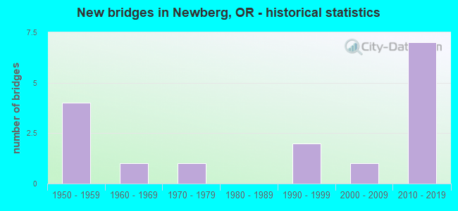
- New bridges - historical statistics
- 41950-1959
- 11960-1969
- 11970-1979
- 21990-1999
- 12000-2009
- 72010-2019


- Bridge Condition - Deck
- 23.1%Very good
- 23.1%Good
- 46.2%Satisfactory
- 7.7%Fair

- Bridge Condition - Superstructure
- 15.4%Very good
- 46.2%Good
- 38.5%Satisfactory

- Bridge Condition - Substructure
- 30.8%Very good
- 15.4%Good
- 38.5%Satisfactory
- 15.4%Fair

- Bridge Condition - Channel
- 27.3%Very good
- 18.2%Good
- 54.5%Satisfactory
Find on map >> Show street view
Structure Number: 2054A01W 0242, Location: 001 MI SW NEWBERG (Lat: 45.297500, Lng: -122.987600), Route carried "on" structure: State highway 99, Year Built: 1975, Status: Open, Structure Length: 24.96m (81.89ft), Average Daily Traffic: 16,095 (year 2020), Truck Traffic: 7%, Average Future Daily Traffic: 19,300 (year 2040), Design Load: HS 20, Features Intersected: Chehalem Creek
Minimum Vertical Clearance: 30+ m (98+ ft), Kilometerpoint: 39.091, Lanes on structure: 4, Base Highway Network: Yes, Owner: State Highway Agency, Approaching Roadway Width: 20.7m (67.9ft), Skew: 3 degrees, Material/Design: Prestressed concrete continuous, Design/Construction: Stringer/Multi-beam, Number Of Spans In Main Unit: 7, Length of Maximum Span: 35.7m (117.1ft), Curb or Sidewalk Widths: Left: 1.5m (4.9ft), Right: 1.5m (4.9ft), Curb-To-Curb Width: 20.7m (67.9ft), Out-to-Out Width: 25.1m (82.3ft)
Condition: Deck: Satisfactory, Superstructure: Good, Substructure: Satisfactory, Channel: Satisfactory, Operating Rating: 23.0 metric tons, Method Used To Determine Operating Rating: Load and Resistance Factor Rating (LRFR) rating reported by rating factor(RF) method using HL-93 loadings, Inventory Rating: 17.8 metric tons, Method Used To Determine Inventory Rating: Load and Resistance Factor Rating (LRFR) rating reported by rating factor(RF) method using HL-93 loadings, Structural Evaluation: Meets minimum limits, Deck Geometry: Superior to present desirable criteria, Waterway Adequacy: Equal to present desirable criteria, Approach Roadway Alignment: Equal to present desirable criteria, Designated Inspection Frequency: Every 24 months, Underwater Inspection Frequency: Every 60 months, Inspection Date: April 2021, Underwater Inspection Date: May 2020, Deck Structure Type: Concrete Cast-file-Place, Wearing Surface/Protective System: Wearing Surface: Monolithic Concrete
Find on map >> Show street view
Structure Number: 8155 140 02307, Location: 020 MI S NEWBERG (Lat: 45.273139, Lng: -122.944089), Route carried "on" structure: State highway 219, Year Built: 1958, Status: Open, Structure Length: 6.86m (22.51ft), Average Daily Traffic: 14,338 (year 2020), Truck Traffic: 6%, Average Future Daily Traffic: 20,900 (year 2040), Design Load: HS 20, Features Intersected: Hess Creek
Minimum Vertical Clearance: 30+ m (98+ ft), Kilometerpoint: 37.144, Lanes on structure: 2, Base Highway Network: Yes, Owner: State Highway Agency, Approaching Roadway Width: 9.1m (29.9ft), Material/Design: Concrete, Design/Construction: Stringer/Multi-beam, Number Of Spans In Main Unit: 9, Length of Maximum Span: 7.6m (24.9ft), Curb-To-Curb Width: 9.1m (29.9ft), Out-to-Out Width: 10.6m (34.8ft)
Condition: Deck: Fair, Superstructure: Satisfactory, Substructure: Satisfactory, Channel: Very good, Operating Rating: 35.6 metric tons, Method Used To Determine Operating Rating: Load and Resistance Factor Rating (LRFR) rating reported by rating factor(RF) method using HL-93 loadings, Inventory Rating: 27.5 metric tons, Method Used To Determine Inventory Rating: Load and Resistance Factor Rating (LRFR) rating reported by rating factor(RF) method using HL-93 loadings, Structural Evaluation: Equal to present minimum criteria, Deck Geometry: Meets minimum limits, Waterway Adequacy: Equal to present desirable criteria, Approach Roadway Alignment: Equal to present desirable criteria, Designated Inspection Frequency: Every 24 months, Inspection Date: September 2021, Deck Structure Type: Concrete Cast-file-Place, Wearing Surface/Protective System: Wearing Surface: Bituminous
Find on map >> Show street view
Structure Number: 8156 140 02346, Location: 023 MI S NEWBERG (Lat: 45.267561, Lng: -122.943369), Route carried "on" structure: State highway 219, Year Built: 1958, Status: Open, Structure Length: 33.24m (109.06ft), Average Daily Traffic: 4,094 (year 2020), Truck Traffic: 16%, Average Future Daily Traffic: 5,300 (year 2040), Design Load: HS 20, Features Intersected: Willamette River
Minimum Vertical Clearance: 30+ m (98+ ft), Kilometerpoint: 37.755, Lanes on structure: 2, Base Highway Network: Yes, Owner: State Highway Agency, Approaching Roadway Width: 10.7m (35.1ft), Material/Design: Steel continuous, Design/Construction: Girder and Floorbeam System, Number Of Spans In Main Unit: 4, Number Of Approach Spans: 6, Length of Maximum Span: 76.2m (250.0ft), Curb-To-Curb Width: 9.1m (29.9ft), Out-to-Out Width: 10.7m (35.1ft)
Condition: Deck: Satisfactory, Superstructure: Satisfactory, Substructure: Fair, Channel: Satisfactory, Operating Rating: 27.2 metric tons, Method Used To Determine Operating Rating: Load and Resistance Factor Rating (LRFR) rating reported by rating factor(RF) method using HL-93 loadings, Inventory Rating: 21.1 metric tons, Method Used To Determine Inventory Rating: Load and Resistance Factor Rating (LRFR) rating reported by rating factor(RF) method using HL-93 loadings, Structural Evaluation: Somewhat better than minimum adequacy, Deck Geometry: Meets minimum limits, Waterway Adequacy: Equal to present desirable criteria, Approach Roadway Alignment: Equal to present desirable criteria, Designated Inspection Frequency: Every 24 months, Critical Feature Inspection Frequency: Every 24 months, Underwater Inspection Frequency: Every 36 months, Inspection Date: September 2021, Critical Feature Inspection Date: September 2021, Underwater Inspection Date: October 2020, Deck Structure Type: Concrete Cast-file-Place, Wearing Surface/Protective System: Wearing Surface: Latex Concrete
Find on map >> Show street view
Structure Number: 8157 140 02366, Location: 00.2 MI S YAM MARION CO L (Lat: 45.264689, Lng: -122.943011), Route carried "on" structure: State highway 219, Year Built: 1958, Status: Open, Structure Length: 4.57m (14.99ft), Average Daily Traffic: 4,094 (year 2020), Truck Traffic: 16%, Average Future Daily Traffic: 5,300 (year 2040), Design Load: HS 20, Features Intersected: Willamette River Oflow
Minimum Vertical Clearance: 30+ m (98+ ft), Kilometerpoint: 38.077, Lanes on structure: 2, Base Highway Network: Yes, Owner: State Highway Agency, Approaching Roadway Width: 9.1m (29.9ft), Material/Design: Concrete, Design/Construction: Stringer/Multi-beam, Number Of Spans In Main Unit: 6, Length of Maximum Span: 7.6m (24.9ft), Curb-To-Curb Width: 9.1m (29.9ft), Out-to-Out Width: 10.6m (34.8ft)
Condition: Deck: Good, Superstructure: Satisfactory, Substructure: Satisfactory, Channel: Very good, Operating Rating: 38.6 metric tons, Method Used To Determine Operating Rating: Load and Resistance Factor Rating (LRFR) rating reported by rating factor(RF) method using HL-93 loadings, Inventory Rating: 29.8 metric tons, Method Used To Determine Inventory Rating: Load and Resistance Factor Rating (LRFR) rating reported by rating factor(RF) method using HL-93 loadings, Structural Evaluation: Equal to present minimum criteria, Deck Geometry: Meets minimum limits, Waterway Adequacy: Equal to present desirable criteria, Approach Roadway Alignment: Equal to present desirable criteria, Designated Inspection Frequency: Every 24 months, Inspection Date: September 2021, Deck Structure Type: Concrete Cast-file-Place, Wearing Surface/Protective System: Wearing Surface: Bituminous, Membrane: Epoxy
Find on map >> Show street view
Structure Number: 8158 140 02389, Location: 042 MI N ST PAUL (Lat: 45.261450, Lng: -122.942589), Route carried "on" structure: State highway 219, Year Built: 1958, Status: Open, Structure Length: 12.95m (42.49ft), Average Daily Traffic: 4,094 (year 2020), Truck Traffic: 16%, Average Future Daily Traffic: 5,300 (year 2040), Design Load: HS 20, Features Intersected: Willamette River Oflow
Minimum Vertical Clearance: 30+ m (98+ ft), Kilometerpoint: 38.447, Lanes on structure: 2, Base Highway Network: Yes, Owner: State Highway Agency, Approaching Roadway Width: 9.1m (29.9ft), Material/Design: Concrete continuous, Design/Construction: Stringer/Multi-beam, Number Of Spans In Main Unit: 17, Length of Maximum Span: 7.6m (24.9ft), Curb-To-Curb Width: 9.1m (29.9ft), Out-to-Out Width: 10.6m (34.8ft)
Condition: Deck: Satisfactory, Superstructure: Satisfactory, Substructure: Satisfactory, Channel: Very good, Operating Rating: 38.6 metric tons, Method Used To Determine Operating Rating: Load and Resistance Factor Rating (LRFR) rating reported by rating factor(RF) method using HL-93 loadings, Inventory Rating: 29.8 metric tons, Method Used To Determine Inventory Rating: Load and Resistance Factor Rating (LRFR) rating reported by rating factor(RF) method using HL-93 loadings, Structural Evaluation: Equal to present minimum criteria, Deck Geometry: Meets minimum limits, Waterway Adequacy: Equal to present desirable criteria, Approach Roadway Alignment: Equal to present desirable criteria, Designated Inspection Frequency: Every 24 months, Inspection Date: September 2021, Deck Structure Type: Concrete Cast-file-Place, Wearing Surface/Protective System: Wearing Surface: Bituminous
Find on map >> Show street view
Structure Number: 11767F, Location: 0.25 MI SW NEWBURG (Lat: 45.292619, Lng: -122.982900), Route carried "on" structure: County highway C0119, Year Built: 1965, Status: Open, Structure Length: 3.96m (12.99ft), Average Daily Traffic: 2,093 (year 2020), Truck Traffic: 1%, Average Future Daily Traffic: 2,353 (year 2025), Design Load: HS 20, Features Intersected: CHEHALEM CREEK, Facility Carried by Structure: DAYTON AVENUE
Minimum Vertical Clearance: 30+ m (98+ ft), Kilometerpoint: 0.000, Lanes on structure: 2, Owner: County Highway Agency, Approaching Roadway Width: 7.0m (23.0ft), Material/Design: Prestressed concrete, Design/Construction: Slab, Number Of Spans In Main Unit: 3, Length of Maximum Span: 15.2m (49.9ft), Curb or Sidewalk Widths: Left: 2.1m (6.9ft), Right: 0.0m, Curb-To-Curb Width: 6.9m (22.6ft), Out-to-Out Width: 7.3m (24.0ft)
Condition: Deck: Satisfactory, Superstructure: Satisfactory, Substructure: Fair, Channel: Satisfactory, Operating Rating: 66.2 metric tons, Method Used To Determine Operating Rating: Load Factor (LF), Inventory Rating: 39.9 metric tons, Method Used To Determine Inventory Rating: Load Factor (LF), Structural Evaluation: Somewhat better than minimum adequacy, Deck Geometry: High priority of replacement, Waterway Adequacy: Equal to present desirable criteria, Approach Roadway Alignment: Equal to present desirable criteria, Length Of Structure Improvement: 4.00m (13.12ft), Designated Inspection Frequency: Every 24 months, Inspection Date: October 2020, Bridge Improvement Cost: $416,000, Roadway Improvement Cost: $42,000, Total Project Cost: $666,000, Deck Structure Type: Other, Wearing Surface/Protective System: Wearing Surface: Bituminous
Find on map >> Show street view
Structure Number: 17451 151 01097, Location: 0.1 MI S NEWBERG (Lat: 45.306817, Lng: -122.982233), Route carried "on" structure: State highway 240, Year Built: 1996, Status: Open, Structure Length: 8.26m (27.10ft), Average Daily Traffic: 7,883 (year 2020), Truck Traffic: 14%, Average Future Daily Traffic: 9,800 (year 2040), Design Load: HS 25 or greater, Features Intersected: East Fork Chehalem Creek
Minimum Vertical Clearance: 30+ m (98+ ft), Kilometerpoint: 17.655, Lanes on structure: 2, Base Highway Network: Yes, Owner: State Highway Agency, Approaching Roadway Width: 12.2m (40.0ft), Material/Design: Prestressed concrete continuous, Design/Construction: Stringer/Multi-beam, Number Of Spans In Main Unit: 3, Length of Maximum Span: 27.7m (90.9ft), Curb or Sidewalk Widths: Left: 2.1m (6.9ft), Right: 2.1m (6.9ft), Curb-To-Curb Width: 12.2m (40.0ft), Out-to-Out Width: 17.1m (56.1ft)
Condition: Deck: Satisfactory, Superstructure: Good, Substructure: Good, Channel: Satisfactory, Operating Rating: 35.3 metric tons, Method Used To Determine Operating Rating: Load and Resistance Factor Rating (LRFR) rating reported by rating factor(RF) method using HL-93 loadings, Inventory Rating: 27.2 metric tons, Method Used To Determine Inventory Rating: Load and Resistance Factor Rating (LRFR) rating reported by rating factor(RF) method using HL-93 loadings, Structural Evaluation: Equal to present minimum criteria, Deck Geometry: Somewhat better than minimum adequacy, Waterway Adequacy: Equal to present desirable criteria, Approach Roadway Alignment: Equal to present desirable criteria, Designated Inspection Frequency: Every 24 months, Inspection Date: March 2021, Deck Structure Type: Concrete Cast-file-Place, Wearing Surface/Protective System: Wearing Surface: Epoxy Overlay, Deck Protection: Epoxy Coated Reinforcing
Find on map >> Show street view
Structure Number: 18143 030 0007, Location: AT W CL NEWBERG (Lat: 45.299969, Lng: -122.988789), Route carried "on" structure: County highway A0703, Year Built: 1997, Status: Open, Structure Length: 4.05m (13.29ft), Average Daily Traffic: 1,093 (year 2020), Truck Traffic: 5%, Average Future Daily Traffic: 1,213 (year 2025), Design Load: HS 25 or greater, Features Intersected: CHEHALEM CREEK, Facility Carried by Structure: SUNNYCREST ROAD
Minimum Vertical Clearance: 30+ m (98+ ft), Kilometerpoint: 1.127, Lanes on structure: 2, Owner: County Highway Agency, Approaching Roadway Width: 7.0m (23.0ft), Material/Design: Prestressed concrete, Design/Construction: Tee Beam, Number Of Spans In Main Unit: 1, Length of Maximum Span: 39.9m (130.9ft), Curb-To-Curb Width: 8.9m (29.2ft), Out-to-Out Width: 9.8m (32.2ft)
Condition: Deck: Satisfactory, Superstructure: Good, Substructure: Satisfactory, Channel: Satisfactory, Operating Rating: 68.9 metric tons, Method Used To Determine Operating Rating: Load Factor (LF), Inventory Rating: 40.8 metric tons, Method Used To Determine Inventory Rating: Load Factor (LF), Structural Evaluation: Equal to present minimum criteria, Deck Geometry: Somewhat better than minimum adequacy, Waterway Adequacy: Equal to present desirable criteria, Approach Roadway Alignment: Equal to present desirable criteria, Designated Inspection Frequency: Every 24 months, Inspection Date: October 2020, Deck Structure Type: Other, Wearing Surface/Protective System: Wearing Surface: Bituminous
Find on map >> Show street view
Structure Number: 19153 151 00966, Location: 015 MI E NEWBERG (Lat: 45.313600, Lng: -123.006700), Route carried "on" structure: State highway 240, Year Built: 2003, Status: Open, Structure Length: 2.35m (7.71ft), Average Daily Traffic: 7,806 (year 2020), Truck Traffic: 14%, Average Future Daily Traffic: 9,000 (year 2040), Design Load: HL 93, Features Intersected: Chehalem Creek
Minimum Vertical Clearance: 30+ m (98+ ft), Kilometerpoint: 15.546, Lanes on structure: 2, Base Highway Network: Yes, Owner: State Highway Agency, Approaching Roadway Width: 11.4m (37.4ft), Material/Design: Prestressed concrete, Design/Construction: Slab, Number Of Spans In Main Unit: 1, Length of Maximum Span: 23.5m (77.1ft), Curb-To-Curb Width: 11.4m (37.4ft), Out-to-Out Width: 12.2m (40.0ft)
Condition: Deck: Good, Superstructure: Good, Substructure: Good, Channel: Satisfactory, Operating Rating: 60.9 metric tons, Method Used To Determine Operating Rating: Load and Resistance Factor Rating (LRFR) rating reported by rating factor(RF) method using HL-93 loadings, Inventory Rating: 47.0 metric tons, Method Used To Determine Inventory Rating: Load and Resistance Factor Rating (LRFR) rating reported by rating factor(RF) method using HL-93 loadings, Structural Evaluation: Better than present minimum criteria, Deck Geometry: Meets minimum limits, Waterway Adequacy: Equal to present desirable criteria, Approach Roadway Alignment: Equal to present desirable criteria, Designated Inspection Frequency: Every 24 months, Inspection Date: March 2021, Deck Structure Type: Concrete Precast Panels, Wearing Surface/Protective System: Wearing Surface: Bituminous, Membrane: Preformed Fabric
Find on map >> Show street view
Structure Number: 22004 039 0564, Location: MP 56.40 (Lat: 45.271769, Lng: -123.004669), Route carried "on" structure: State highway 18, Year Built: 2016, Status: Open, Structure Length: 4.74m (15.55ft), Average Daily Traffic: 10,620 (year 2020), Truck Traffic: 6%, Average Future Daily Traffic: 17,000 (year 2040), Design Load: HL 93, Features Intersected: Unnamed Creek
Minimum Vertical Clearance: 30+ m (98+ ft), Kilometerpoint: 90.767, Lanes on structure: 2, Base Highway Network: Yes, Owner: State Highway Agency, Approaching Roadway Width: 12.8m (42.0ft), Material/Design: Prestressed concrete, Design/Construction: Stringer/Multi-beam, Number Of Spans In Main Unit: 1, Length of Maximum Span: 47.4m (155.5ft), Curb-To-Curb Width: 12.8m (42.0ft), Out-to-Out Width: 13.9m (45.6ft)
Condition: Deck: Good, Superstructure: Good, Substructure: Very good, Channel: Good, Operating Rating: 78.1 metric tons, Method Used To Determine Operating Rating: Load and Resistance Factor Rating (LRFR) rating reported by rating factor(RF) method using HL-93 loadings, Inventory Rating: 60.3 metric tons, Method Used To Determine Inventory Rating: Load and Resistance Factor Rating (LRFR) rating reported by rating factor(RF) method using HL-93 loadings, Structural Evaluation: Better than present minimum criteria, Deck Geometry: Somewhat better than minimum adequacy, Waterway Adequacy: Equal to present desirable criteria, Approach Roadway Alignment: Equal to present desirable criteria, Designated Inspection Frequency: Every 24 months, Inspection Date: November 2020, Deck Structure Type: Concrete Cast-file-Place, Wearing Surface/Protective System: Wearing Surface: Monolithic Concrete
Find on map >> Show street view
Structure Number: 22009 039 05848, Location: MP 58.48 (Lat: 45.289317, Lng: -122.970778), Route carried "on" structure: State highway 18, Year Built: 2016, Status: Open, Structure Length: 76.20m (250.00ft), Average Daily Traffic: 12,493 (year 2020), Truck Traffic: 6%, Average Future Daily Traffic: 20,000 (year 2040), Design Load: HL 93, Features Intersected: RR, College/River St
Minimum Vertical Clearance: 30+ m (98+ ft), Kilometerpoint: 94.114, Lanes on structure: 2, Lanes under structure: 6, Base Highway Network: Yes, Owner: State Highway Agency, Approaching Roadway Width: 12.8m (42.0ft), Material/Design: Prestressed concrete continuous, Design/Construction: Stringer/Multi-beam, Number Of Spans In Main Unit: 16, Length of Maximum Span: 762.0m (2,500.0ft), Curb-To-Curb Width: 12.8m (42.0ft), Out-to-Out Width: 13.5m (44.3ft)
Condition: Deck: Very good, Superstructure: Very good, Substructure: Very good, Operating Rating: 42.8 metric tons, Method Used To Determine Operating Rating: Load and Resistance Factor Rating (LRFR) rating reported by rating factor(RF) method using HL-93 loadings, Inventory Rating: 33.0 metric tons, Method Used To Determine Inventory Rating: Load and Resistance Factor Rating (LRFR) rating reported by rating factor(RF) method using HL-93 loadings, Structural Evaluation: Equal to present desirable criteria, Deck Geometry: Somewhat better than minimum adequacy, Underclear: High priority of corrective action, Approach Roadway Alignment: Equal to present desirable criteria, Designated Inspection Frequency: Every 24 months, Inspection Date: November 2020, Deck Structure Type: Concrete Cast-file-Place, Wearing Surface/Protective System: Wearing Surface: Monolithic Concrete
Find on map >> Show street view
Structure Number: 22012 000 00105, Location: Hwy 39 MP 59.13 (Lat: 45.290556, Lng: -122.957778), Route carried "on" structure: City street , Year Built: 2016, Status: Open, Structure Length: 20.88m (68.50ft), Average Daily Traffic: 12,493 (year 2020), Truck Traffic: 6%, Average Future Daily Traffic: 20,000 (year 2040), Design Load: HL 93, Features Intersected: Hwy 039, Facility Carried by Structure: Wynooski Street
Minimum Vertical Clearance: 30+ m (98+ ft), Kilometerpoint: 95.161, Lanes on structure: 2, Lanes under structure: 2, Owner: State Highway Agency, Approaching Roadway Width: 10.4m (34.1ft), Material/Design: Prestressed concrete continuous, Design/Construction: Box Beam or Girders - Multiple, Number Of Spans In Main Unit: 4, Length of Maximum Span: 64.0m (210.0ft), Curb or Sidewalk Widths: Left: 2.1m (6.9ft), Right: 2.1m (6.9ft), Curb-To-Curb Width: 10.4m (34.1ft), Out-to-Out Width: 15.4m (50.5ft)
Condition: Deck: Very good, Superstructure: Very good, Substructure: Very good, Operating Rating: 61.2 metric tons, Method Used To Determine Operating Rating: Load and Resistance Factor Rating (LRFR) rating reported by rating factor(RF) method using HL-93 loadings, Inventory Rating: 47.3 metric tons, Method Used To Determine Inventory Rating: Load and Resistance Factor Rating (LRFR) rating reported by rating factor(RF) method using HL-93 loadings, Structural Evaluation: Equal to present desirable criteria, Deck Geometry: Meets minimum limits, Underclear: High priority of corrective action, Approach Roadway Alignment: Equal to present desirable criteria, Designated Inspection Frequency: Every 24 months, Inspection Date: November 2020, Deck Structure Type: Concrete Cast-file-Place, Wearing Surface/Protective System: Wearing Surface: Monolithic Concrete
Find on map >> Show street view
Structure Number: 22013 039 05924, Location: MP 59.26 (Lat: 45.290100, Lng: -122.955828), Route carried "on" structure: State highway 18, Year Built: 2016, Status: Open, Structure Length: 18.29m (60.01ft), Average Daily Traffic: 12,493 (year 2020), Truck Traffic: 6%, Average Future Daily Traffic: 20,000 (year 2040), Design Load: HL 93, Features Intersected: Hess Creek
Minimum Vertical Clearance: 30+ m (98+ ft), Kilometerpoint: 95.338, Lanes on structure: 2, Base Highway Network: Yes, Owner: State Highway Agency, Approaching Roadway Width: 15.8m (51.8ft), Skew: 2 degrees, Material/Design: Prestressed concrete continuous, Design/Construction: Stringer/Multi-beam, Number Of Spans In Main Unit: 4, Length of Maximum Span: 54.9m (180.1ft), Curb-To-Curb Width: 15.8m (51.8ft), Out-to-Out Width: 16.9m (55.4ft)
Condition: Deck: Very good, Superstructure: Good, Substructure: Very good, Channel: Good, Operating Rating: 27.9 metric tons, Method Used To Determine Operating Rating: Load and Resistance Factor Rating (LRFR) rating reported by rating factor(RF) method using HL-93 loadings, Inventory Rating: 21.4 metric tons, Method Used To Determine Inventory Rating: Load and Resistance Factor Rating (LRFR) rating reported by rating factor(RF) method using HL-93 loadings, Structural Evaluation: Somewhat better than minimum adequacy, Deck Geometry: Superior to present desirable criteria, Waterway Adequacy: Equal to present desirable criteria, Approach Roadway Alignment: Equal to present desirable criteria, Designated Inspection Frequency: Every 24 months, Inspection Date: November 2020, Deck Structure Type: Concrete Cast-file-Place, Wearing Surface/Protective System: Wearing Surface: Monolithic Concrete
Find on map >> Show street view
Structure Number: 22009 039 05848, Location: MP 58.48 (Lat: 45.289317, Lng: -122.970778), Route carried "under" structure: City street , Year Built: 2016, Structure Length: 0. m, Average Daily Traffic: 10 (year 2021), Features Intersected: RR, College/River St, Facility Carried by Structure: Hwy 039 (OR 18)
Minimum Vertical Clearance: 6.99m (22.93ft), Kilometerpoint: 0.000, Lanes on structure: 2, Lanes under structure: 2, Material/Design: Prestressed concrete continuous, Design/Construction: Stringer/Multi-beam, Length of Maximum Span: 762.0m (2,500.0ft)
Find on map >> Show street view
Structure Number: 22009 039 05848, Location: MP 58.48 (Lat: 45.289317, Lng: -122.970778), Route carried "under" structure: City street , Year Built: 2016, Structure Length: 0. m, Average Daily Traffic: 10 (year 2021), Features Intersected: RR, College/River St, Facility Carried by Structure: Hwy 039 (OR 18)
Minimum Vertical Clearance: 7.03m (23.06ft), Kilometerpoint: 0.000, Lanes on structure: 2, Lanes under structure: 2, Material/Design: Prestressed concrete continuous, Design/Construction: Stringer/Multi-beam, Length of Maximum Span: 762.0m (2,500.0ft)
Find on map >> Show street view
Structure Number: 22012 000 00105, Location: Hwy 39 MP 59.13 (Lat: 45.290556, Lng: -122.957778), Route carried "under" structure: State highway 39, Year Built: 2016, Structure Length: 0. m, Average Daily Traffic: 12,493 (year 2020), Truck Traffic: 6%, Features Intersected: Hwy 039, Facility Carried by Structure: Wynooski Street
Minimum Vertical Clearance: 5.28m (17.32ft), Kilometerpoint: 95.209, Lanes on structure: 2, Lanes under structure: 2, Material/Design: Prestressed concrete continuous, Design/Construction: Box Beam or Girders - Multiple, Length of Maximum Span: 64.0m (210.0ft)