Bridge Statistics for Needham, Massachusetts (MA)
Condition, Traffic, Stress, Structural Evaluation, Project Costs
- National Bridge Inventory (NBI) Statistics
- 17Number of bridges
- 243ft / 73.5mTotal length
- $13,808,000Total costs
- 431,985Total average daily traffic
- 23,686Total average daily truck traffic
- National Bridge Inventory (NBI) Registered Bridges for Needham
- No street view available for this location
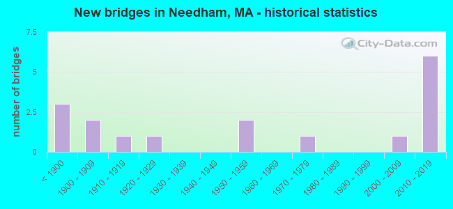
- New bridges - historical statistics
- 3Before 1900
- 21900-1909
- 11910-1919
- 11920-1929
- 21950-1959
- 11970-1979
- 12000-2009
- 62010-2019

- Reconstructed bridges - Historical Statistics
- 11920-1929
- 01930-1939
- 01940-1949
- 01950-1959
- 11960-1969
- 11970-1979
- 21980-1989
- 01990-1999
- 02000-2009
- 22010-2019


- Bridge Condition - Deck
- 41.7%Very good
- 25.0%Good
- 8.3%Satisfactory
- 25.0%Fair

- Bridge Condition - Superstructure
- 29.4%Very good
- 29.4%Good
- 29.4%Satisfactory
- 11.8%Fair

- Bridge Condition - Substructure
- 17.6%Very good
- 52.9%Good
- 11.8%Satisfactory
- 17.6%Fair

- Bridge Condition - Channel
- 28.6%Very good
- 28.6%Good
- 42.9%Satisfactory
Find on map >> Show street view
Structure Number: D05001366DOTNBI, Location: 0.48 KM NW OF ST 128 (Lat: 42.267706, Lng: -71.218142), Route carried "on" structure: State highway 135, Year Built: 1909, Status: Open, Structure Length: 1.71m (5.61ft), Average Daily Traffic: 27,000 (year 2019), Truck Traffic: 3%, Average Future Daily Traffic: 38,219 (year 2032), Features Intersected: WATER CHARLES RIVER
Minimum Vertical Clearance: 30+ m (98+ ft), Kilometerpoint: 0.000, Lanes on structure: 2, Base Highway Network: Yes, Owner: State Highway Agency, Approaching Roadway Width: 11.0m (36.1ft), Skew: 3 degrees, Material/Design: Concrete, Design/Construction: Arch - Deck, Number Of Spans In Main Unit: 2, Length of Maximum Span: 7.0m (23.0ft), Curb-To-Curb Width: 8.7m (28.5ft), Out-to-Out Width: 10.7m (35.1ft)
Condition: Superstructure: Satisfactory, Substructure: Satisfactory, Channel: Satisfactory, Structural Evaluation: Equal to present minimum criteria, Deck Geometry: High priority of replacement, Waterway Adequacy: Equal to present desirable criteria, Approach Roadway Alignment: Equal to present minimum criteria, Length Of Structure Improvement: 1.80m (5.91ft), Designated Inspection Frequency: Every 24 months, Underwater Inspection Frequency: Every 36 months, Inspection Date: July 2021, Underwater Inspection Date: March 2021, Bridge Improvement Cost: $798,000, Roadway Improvement Cost: $80,000, Total Project Cost: $1,198,000 ( Estimate for 2022), Wearing Surface/Protective System: Wearing Surface: Bituminous
Find on map >> Show street view
Structure Number: D05039B8JDOTNBI, Location: .1 MI.SW OF GRT PLAIN AVE (Lat: 42.267231, Lng: -71.203575), Route carried "on" structure: Interstate 95, Year Built: 2015, Status: Open, Structure Length: 11.22m (36.81ft), Average Daily Traffic: 57,881 (year 2020), Truck Traffic: 7%, Design Load: HS 25 or greater, Features Intersected: WATER CHARLES RIVER
Minimum Vertical Clearance: 30+ m (98+ ft), Kilometerpoint: 0.000, Lanes on structure: 5, Owner: State Highway Agency, Approaching Roadway Width: 25.8m (84.6ft), Skew: 5 degrees, Material/Design: Steel continuous, Design/Construction: Stringer/Multi-beam, Number Of Spans In Main Unit: 3, Length of Maximum Span: 41.5m (136.2ft), Curb-To-Curb Width: 24.8m (81.4ft), Out-to-Out Width: 25.8m (84.6ft)
Condition: Deck: Very good, Superstructure: Very good, Substructure: Good, Channel: Very good, Inventory Rating: 94.8 metric tons, Method Used To Determine Inventory Rating: Load Factor (LF), Structural Evaluation: Better than present minimum criteria, Deck Geometry: Better than present minimum criteria, Waterway Adequacy: Superior to present desirable criteria, Approach Roadway Alignment: Equal to present desirable criteria, Designated Inspection Frequency: Every 24 months, Inspection Date: December 2021, Deck Structure Type: Concrete Cast-file-Place, Wearing Surface/Protective System: Wearing Surface: Bituminous, Membrane: Built-up, Deck Protection: Epoxy Coated Reinforcing
Find on map >> Show street view
Structure Number: D10002AFAMUNNBI, Location: .6 KM E OF NATICK LINE (Lat: 42.269328, Lng: -71.299803), Route carried "on" structure: City street , Year Built: 2002, Status: Open, Structure Length: 3.86m (12.66ft), Average Daily Traffic: 7,500 (year 2018), Truck Traffic: 3%, Average Future Daily Traffic: 12,476 (year 2031), Design Load: HS 20, Features Intersected: WATER CHARLES RIVER, Facility Carried by Structure: HWY DOVER RD
Minimum Vertical Clearance: 30+ m (98+ ft), Kilometerpoint: 0.676, Lanes on structure: 2, Owner: Town or Township Highway Agency, Approaching Roadway Width: 8.5m (27.9ft), Material/Design: Prestressed concrete continuous, Design/Construction: Slab, Number Of Spans In Main Unit: 3, Length of Maximum Span: 13.0m (42.7ft), Curb or Sidewalk Widths: Left: 1.4m (4.6ft), Right: 0.0m, Curb-To-Curb Width: 8.5m (27.9ft), Out-to-Out Width: 11.0m (36.1ft)
Condition: Deck: Good, Superstructure: Good, Substructure: Good, Channel: Very good, Operating Rating: 65.0 metric tons, Method Used To Determine Operating Rating: Load Factor (LF), Inventory Rating: 38.8 metric tons, Method Used To Determine Inventory Rating: Load Factor (LF), Structural Evaluation: Better than present minimum criteria, Deck Geometry: High priority of replacement, Waterway Adequacy: Better than present minimum criteria, Approach Roadway Alignment: Better than present minimum criteria, Length Of Structure Improvement: 3.90m (12.80ft), Designated Inspection Frequency: Every 24 months, Underwater Inspection Frequency: Every 36 months, Inspection Date: August 2020, Underwater Inspection Date: July 2020, Bridge Improvement Cost: $1,802,000, Roadway Improvement Cost: $181,000, Total Project Cost: $2,704,000 ( Estimate for 2022), Deck Structure Type: Concrete Precast Panels, Wearing Surface/Protective System: Wearing Surface: Bituminous, Membrane: Built-up, Deck Protection: Epoxy Coated Reinforcing
Find on map >> Show street view
Structure Number: D1000333NMUNNBI, Location: DOVER-NEEDHAM TOWN LINE (Lat: 42.259039, Lng: -71.271436), Route carried "on" structure: City street , Year Built: 1847, Status: Open, Structure Length: 2.07m (6.79ft), Average Daily Traffic: 11,900 (year 2020), Truck Traffic: 3%, Average Future Daily Traffic: 13,898 (year 2033), Features Intersected: WATER CHARLES RIVER, Facility Carried by Structure: HWY CENTRE ST
Minimum Vertical Clearance: 30+ m (98+ ft), Kilometerpoint: 6.485, Lanes on structure: 2, Owner: Town or Township Highway Agency, Approaching Roadway Width: 6.7m (22.0ft), Material/Design: Masonry, Design/Construction: Arch - Deck, Number Of Spans In Main Unit: 3, Length of Maximum Span: 5.8m (19.0ft), Curb-To-Curb Width: 5.5m (18.0ft), Out-to-Out Width: 6.6m (21.7ft)
Condition: Superstructure: Satisfactory, Substructure: Fair, Channel: Satisfactory, Inventory Rating: 53.6 metric tons, Method Used To Determine Inventory Rating: Allowable Stress (AS), Structural Evaluation: Somewhat better than minimum adequacy, Deck Geometry: High priority of replacement, Waterway Adequacy: Superior to present desirable criteria, Approach Roadway Alignment: Meets minimum limits, Length Of Structure Improvement: 2.10m (6.89ft), Designated Inspection Frequency: Every 24 months, Underwater Inspection Frequency: Every 36 months, Inspection Date: March 2020, Underwater Inspection Date: September 2020, Bridge Improvement Cost: $545,000, Roadway Improvement Cost: $55,000, Total Project Cost: $818,000 ( Estimate for 2022)
Find on map >> Show street view
Structure Number: D10004B26MUNNBI, Location: 1.1 KM N OF DEDHAM (Lat: 42.259250, Lng: -71.263183), Route carried "on" structure: City street , Year Built: 2013, Status: Open, Structure Length: 1.69m (5.54ft), Average Daily Traffic: 1,700 (year 2019), Truck Traffic: 8%, Design Load: HL 93, Features Intersected: WATER CHARLES RIVER, Facility Carried by Structure: HWY WILLOW ST
Minimum Vertical Clearance: 30+ m (98+ ft), Kilometerpoint: 1.175, Lanes on structure: 2, Owner: Town or Township Highway Agency, Approaching Roadway Width: 8.9m (29.2ft), Material/Design: Concrete, Design/Construction: Arch - Deck, Number Of Spans In Main Unit: 1, Length of Maximum Span: 16.9m (55.4ft), Curb or Sidewalk Widths: Left: 1.7m (5.6ft), Right: 0.0m, Curb-To-Curb Width: 8.9m (29.2ft), Out-to-Out Width: 12.0m (39.4ft)
Condition: Superstructure: Good, Substructure: Good, Channel: Good, Operating Rating: 68.0 metric tons, Method Used To Determine Operating Rating: Load and Resistance Factor Rating (LRFR) rating reported by rating factor(RF) method using HL-93 loadings, Inventory Rating: 45.4 metric tons, Method Used To Determine Inventory Rating: Load and Resistance Factor Rating (LRFR) rating reported by rating factor(RF) method using HL-93 loadings, Structural Evaluation: Better than present minimum criteria, Deck Geometry: Somewhat better than minimum adequacy, Waterway Adequacy: Equal to present desirable criteria, Approach Roadway Alignment: Somewhat better than minimum adequacy, Length Of Structure Improvement: 1.70m (5.58ft), Designated Inspection Frequency: Every 24 months, Underwater Inspection Frequency: Every 36 months, Inspection Date: October 2021, Underwater Inspection Date: September 2021, Bridge Improvement Cost: $41,000, Roadway Improvement Cost: $5,000, Total Project Cost: $62,000 ( Estimate for 2022), Deck Structure Type: Concrete Precast Panels, Wearing Surface/Protective System: Wearing Surface: Bituminous
Find on map >> Show street view
Structure Number: D10005367DOTNBI, Location: 0.16 KM N OF DEDHAM ST (Lat: 42.259850, Lng: -71.237136), Route carried "on" structure: Other road , Year Built: 1922, Year Reconstructed: 1977, Status: Open, Structure Length: 3.38m (11.09ft), Average Daily Traffic: 10,344 (year 2021), Truck Traffic: 10%, Average Future Daily Traffic: 13,582 (year 2032), Design Load: H 20, Features Intersected: WATER CHARLES RIVER, Facility Carried by Structure: HWY CHESTNUT ST
Minimum Vertical Clearance: 30+ m (98+ ft), Kilometerpoint: 0.000, Lanes on structure: 2, Owner: State Highway Agency, Approaching Roadway Width: 10.4m (34.1ft), Material/Design: Prestressed concrete, Design/Construction: Slab, Number Of Spans In Main Unit: 2, Length of Maximum Span: 10.4m (34.1ft), Curb or Sidewalk Widths: Left: 1.5m (4.9ft), Right: 0.0m, Curb-To-Curb Width: 8.5m (27.9ft), Out-to-Out Width: 11.3m (37.1ft)
Condition: Deck: Fair, Superstructure: Fair, Substructure: Satisfactory, Channel: Satisfactory, Operating Rating: 38.7 metric tons, Method Used To Determine Operating Rating: Load Factor (LF), Inventory Rating: 30.3 metric tons, Method Used To Determine Inventory Rating: Load Factor (LF), Structural Evaluation: Somewhat better than minimum adequacy, Deck Geometry: High priority of replacement, Waterway Adequacy: Better than present minimum criteria, Approach Roadway Alignment: Better than present minimum criteria, Length Of Structure Improvement: 3.40m (11.15ft), Designated Inspection Frequency: Every 24 months, Underwater Inspection Frequency: Every 36 months, Inspection Date: November 2021, Underwater Inspection Date: May 2020, Bridge Improvement Cost: $1,510,000, Roadway Improvement Cost: $152,000, Total Project Cost: $2,266,000 ( Estimate for 2022), Deck Structure Type: Concrete Precast Panels, Wearing Surface/Protective System: Wearing Surface: Bituminous, Membrane: Epoxy, Deck Protection: Internally Sealed
Find on map >> Show street view
Structure Number: N0400133PMUNNBI, Location: NEEDHAM/NEWTON TOWN LINE (Lat: 42.312397, Lng: -71.227083), Route carried "on" structure: City street , Year Built: 1860, Year Reconstructed: 1992, Status: Posted for load, Structure Length: 2.62m (8.60ft), Average Daily Traffic: 21,100 (year 2019), Truck Traffic: 5%, Average Future Daily Traffic: 33,165 (year 2031), Features Intersected: WATER CHARLES RIVER, Facility Carried by Structure: HWY CENTRAL AVE
Minimum Vertical Clearance: 30+ m (98+ ft), Kilometerpoint: 0.016, Lanes on structure: 2, Owner: Town or Township Highway Agency, Approaching Roadway Width: 8.5m (27.9ft), Material/Design: Masonry, Design/Construction: Arch - Deck, Number Of Spans In Main Unit: 3, Length of Maximum Span: 8.8m (28.9ft), Curb or Sidewalk Widths: Left: 2.1m (6.9ft), Right: 2.7m (8.9ft), Curb-To-Curb Width: 8.5m (27.9ft), Out-to-Out Width: 13.4m (44.0ft)
Condition: Superstructure: Good, Substructure: Good, Channel: Good, Operating Rating: 97.2 metric tons, Method Used To Determine Operating Rating: Load and Resistance Factor Rating (LRFR) rating reported by rating factor(RF) method using HL-93 loadings, Inventory Rating: 97.2 metric tons, Method Used To Determine Inventory Rating: Load and Resistance Factor Rating (LRFR) rating reported by rating factor(RF) method using HL-93 loadings, Structural Evaluation: Better than present minimum criteria, Deck Geometry: High priority of replacement, Waterway Adequacy: Equal to present desirable criteria, Approach Roadway Alignment: Meets minimum limits, Length Of Structure Improvement: 2.70m (8.86ft), Designated Inspection Frequency: Every 24 months, Underwater Inspection Frequency: Every 36 months, Inspection Date: October 2021, Underwater Inspection Date: April 2021, Bridge Improvement Cost: $1,240,000, Roadway Improvement Cost: $125,000, Total Project Cost: $1,861,000 ( Estimate for 2022), Wearing Surface/Protective System: Wearing Surface: Bituminous
Find on map >> Show street view
Structure Number: N04010376DOT634, Location: NEEDHAM LINE MP 10.39 (Lat: 42.277097, Lng: -71.204253), Route carried "on" structure: City street , Year Built: 1850, Year Reconstructed: 1932, Status: Open, Structure Length: 0.98m (3.22ft), Average Daily Traffic: 8,405 (year 2022), Truck Traffic: 3%, Average Future Daily Traffic: 18,004 (year 2031), Features Intersected: RR MBTA, Facility Carried by Structure: HWY GREENDALE AV
Minimum Vertical Clearance: 30+ m (98+ ft), Kilometerpoint: 0.000, Lanes on structure: 2, Owner: State Highway Agency, Approaching Roadway Width: 10.5m (34.4ft), Material/Design: Concrete, Design/Construction: Arch - Deck, Number Of Spans In Main Unit: 1, Length of Maximum Span: 9.8m (32.2ft), Curb or Sidewalk Widths: Left: 1.8m (5.9ft), Right: 1.5m (4.9ft), Curb-To-Curb Width: 10.5m (34.4ft), Out-to-Out Width: 14.9m (48.9ft)
Condition: Superstructure: Satisfactory, Substructure: Fair, Inventory Rating: 61.0 metric tons, Method Used To Determine Inventory Rating: Load Factor (LF), Structural Evaluation: Somewhat better than minimum adequacy, Deck Geometry: Meets minimum limits, Underclear: Meets minimum limits, Approach Roadway Alignment: Equal to present desirable criteria, Length Of Structure Improvement: 1.00m (3.28ft), Designated Inspection Frequency: Every 24 months, Inspection Date: January 2022, Bridge Improvement Cost: $586,000, Roadway Improvement Cost: $59,000, Total Project Cost: $880,000 ( Estimate for 2022), Wearing Surface/Protective System: Wearing Surface: Bituminous
Find on map >> Show street view
Structure Number: N04011377DOT634, Location: .16 KM W DEDHAM AVE (Lat: 42.275758, Lng: -71.214719), Route carried "on" structure: Other road , Year Built: 1900, Year Reconstructed: 1960, Status: Open, Structure Length: 1.69m (5.54ft), Average Daily Traffic: 13,189 (year 2019), Truck Traffic: 1%, Average Future Daily Traffic: 20,531 (year 2032), Features Intersected: RR MBTA, Facility Carried by Structure: HWY GRT PLN AVE
Minimum Vertical Clearance: 30+ m (98+ ft), Kilometerpoint: 0.000, Lanes on structure: 2, Owner: State Highway Agency, Approaching Roadway Width: 11.0m (36.1ft), Skew: 4 degrees, Material/Design: Steel, Design/Construction: Stringer/Multi-beam, Number Of Spans In Main Unit: 1, Length of Maximum Span: 15.4m (50.5ft), Curb or Sidewalk Widths: Left: 1.5m (4.9ft), Right: 1.5m (4.9ft), Curb-To-Curb Width: 11.0m (36.1ft), Out-to-Out Width: 14.9m (48.9ft)
Condition: Deck: Fair, Superstructure: Satisfactory, Substructure: Fair, Operating Rating: 48.6 metric tons, Method Used To Determine Operating Rating: Load Factor (LF), Inventory Rating: 29.1 metric tons, Method Used To Determine Inventory Rating: Load Factor (LF), Structural Evaluation: Somewhat better than minimum adequacy, Deck Geometry: Meets minimum limits, Underclear: High priority of corrective action, Approach Roadway Alignment: Equal to present minimum criteria, Length Of Structure Improvement: 1.70m (5.58ft), Designated Inspection Frequency: Every 24 months, Inspection Date: July 2021, Bridge Improvement Cost: $995,000, Roadway Improvement Cost: $100,000, Total Project Cost: $1,493,000 ( Estimate for 2022), Deck Structure Type: Concrete Cast-file-Place, Wearing Surface/Protective System: Wearing Surface: Bituminous, Membrane: Built-up
Find on map >> Show street view
Structure Number: N04019379DOT634, Location: .16 KM SE HILLSIDE AVE (Lat: 42.295369, Lng: -71.235933), Route carried "on" structure: City street , Year Built: 1978, Status: Open, Structure Length: 1.39m (4.56ft), Average Daily Traffic: 6,336 (year 2019), Truck Traffic: 4%, Average Future Daily Traffic: 9,002 (year 2032), Design Load: H 20, Features Intersected: RR BCRR/MBTA, Facility Carried by Structure: HWY HUNNEWELL ST
Minimum Vertical Clearance: 30+ m (98+ ft), Kilometerpoint: 0.000, Lanes on structure: 2, Owner: State Highway Agency, Approaching Roadway Width: 8.5m (27.9ft), Skew: 2 degrees, Material/Design: Prestressed concrete, Design/Construction: Slab, Number Of Spans In Main Unit: 1, Length of Maximum Span: 12.4m (40.7ft), Curb or Sidewalk Widths: Left: 1.5m (4.9ft), Right: 1.9m (6.2ft), Curb-To-Curb Width: 8.5m (27.9ft), Out-to-Out Width: 12.0m (39.4ft)
Condition: Deck: Satisfactory, Superstructure: Satisfactory, Substructure: Good, Operating Rating: 56.8 metric tons, Method Used To Determine Operating Rating: Load Factor (LF), Inventory Rating: 34.0 metric tons, Method Used To Determine Inventory Rating: Load Factor (LF), Structural Evaluation: Equal to present minimum criteria, Deck Geometry: High priority of replacement, Underclear: High priority of corrective action, Approach Roadway Alignment: Equal to present minimum criteria, Length Of Structure Improvement: 1.40m (4.59ft), Designated Inspection Frequency: Every 24 months, Inspection Date: July 2021, Bridge Improvement Cost: $647,000, Roadway Improvement Cost: $65,000, Total Project Cost: $971,000 ( Estimate for 2022), Deck Structure Type: Concrete Precast Panels, Wearing Surface/Protective System: Wearing Surface: Bituminous, Membrane: Epoxy, Deck Protection: Internally Sealed
Find on map >> Show street view
Structure Number: N04021BBVDOTNBI, Location: 1.3 KM SE OF ST 9 (Lat: 42.302733, Lng: -71.224986), Route carried "on" structure: City street , Year Built: 2018, Status: Open, Structure Length: 12.62m (41.40ft), Average Daily Traffic: 42,931 (year 2018), Truck Traffic: 7%, Design Load: HL 93, Features Intersected: I 95 /ST128, Facility Carried by Structure: HWY HIGHLAND AVE
Minimum Vertical Clearance: 4.93m (16.17ft), Kilometerpoint: 0.000, Lanes on structure: 6, Lanes under structure: 12, Owner: State Highway Agency, Approaching Roadway Width: 28.0m (91.9ft), Skew: 12 degrees, Material/Design: Steel continuous, Design/Construction: Stringer/Multi-beam, Number Of Spans In Main Unit: 3, Length of Maximum Span: 43.7m (143.4ft), Curb or Sidewalk Widths: Left: 1.7m (5.6ft), Right: 1.7m (5.6ft), Curb-To-Curb Width: 28.0m (91.9ft), Out-to-Out Width: 32.1m (105.3ft)
Condition: Deck: Good, Superstructure: Very good, Substructure: Very good, Operating Rating: 32.4 metric tons, Method Used To Determine Operating Rating: Load and Resistance Factor Rating (LRFR) rating reported by rating factor(RF) method using HL-93 loadings, Inventory Rating: 29.2 metric tons, Method Used To Determine Inventory Rating: Load and Resistance Factor Rating (LRFR) rating reported by rating factor(RF) method using HL-93 loadings, Structural Evaluation: Better than present minimum criteria, Deck Geometry: Superior to present desirable criteria, Underclear: Equal to present minimum criteria, Approach Roadway Alignment: Equal to present desirable criteria, Designated Inspection Frequency: Every 24 months, Inspection Date: October 2020, Deck Structure Type: Concrete Cast-file-Place, Wearing Surface/Protective System: Wearing Surface: Bituminous, Membrane: Other, Deck Protection: Epoxy Coated Reinforcing
Find on map >> Show street view
Structure Number: N0402235WDOTNBI, Location: .5 MI SE OF ST 9 (Lat: 42.310728, Lng: -71.229492), Route carried "on" structure: Interstate 95, Year Built: 1953, Year Reconstructed: 2018, Status: Open, Structure Length: 1.93m (6.33ft), Average Daily Traffic: 79,657 (year 2016), Truck Traffic: 6%, Average Future Daily Traffic: 254,899 (year 2033), Design Load: HL 93, Features Intersected: HWY CENTRAL AVE
Minimum Vertical Clearance: 30+ m (98+ ft), Kilometerpoint: 0.000, Lanes on structure: 5, Lanes under structure: 2, Base Highway Network: Yes, Owner: State Highway Agency, Approaching Roadway Width: 24.1m (79.1ft), Material/Design: Concrete, Design/Construction: Frame, Number Of Spans In Main Unit: 1, Length of Maximum Span: 19.3m (63.3ft), Curb-To-Curb Width: 24.1m (79.1ft), Out-to-Out Width: 26.1m (85.6ft)
Condition: Deck: Very good, Superstructure: Good, Substructure: Good, Operating Rating: 42.1 metric tons, Method Used To Determine Operating Rating: Assigned ratings based on Load and Resistance Factor Design (LRFD) reported by rating factor (RF) using HL93 loadings, Inventory Rating: 32.4 metric tons, Method Used To Determine Inventory Rating: Assigned ratings based on Load and Resistance Factor Design (LRFD) reported by rating factor (RF) using HL93 loadings, Structural Evaluation: Better than present minimum criteria, Deck Geometry: Equal to present minimum criteria, Underclear: Meets minimum limits, Approach Roadway Alignment: Equal to present desirable criteria, Designated Inspection Frequency: Every 24 months, Inspection Date: October 2020, Deck Structure Type: Concrete Cast-file-Place, Wearing Surface/Protective System: Wearing Surface: Bituminous, Membrane: Other, Deck Protection: Epoxy Coated Reinforcing
Find on map >> Show street view
Structure Number: N0402235XDOTNBI, Location: .5 MI SE OF ST 9 (Lat: 42.310614, Lng: -71.229769), Route carried "on" structure: Interstate 95, Year Built: 1953, Year Reconstructed: 2018, Status: Open, Structure Length: 1.93m (6.33ft), Average Daily Traffic: 71,371 (year 2016), Truck Traffic: 6%, Average Future Daily Traffic: 254,899 (year 2033), Design Load: HL 93, Features Intersected: HWY CENTRAL AVE
Minimum Vertical Clearance: 30+ m (98+ ft), Kilometerpoint: 0.000, Lanes on structure: 5, Lanes under structure: 2, Base Highway Network: Yes, Owner: State Highway Agency, Approaching Roadway Width: 24.1m (79.1ft), Material/Design: Concrete, Design/Construction: Frame, Number Of Spans In Main Unit: 1, Length of Maximum Span: 19.2m (63.0ft), Curb-To-Curb Width: 24.1m (79.1ft), Out-to-Out Width: 26.1m (85.6ft)
Condition: Deck: Very good, Superstructure: Very good, Substructure: Good, Inventory Rating: 85.5 metric tons, Method Used To Determine Inventory Rating: Load Factor (LF), Structural Evaluation: Better than present minimum criteria, Deck Geometry: Equal to present minimum criteria, Underclear: Meets minimum limits, Approach Roadway Alignment: Equal to present desirable criteria, Designated Inspection Frequency: Every 24 months, Inspection Date: October 2020, Deck Structure Type: Concrete Cast-file-Place, Wearing Surface/Protective System: Wearing Surface: Bituminous, Membrane: Other, Deck Protection: Epoxy Coated Reinforcing
Find on map >> Show street view
Structure Number: N04024378DOT634, Location: .3 MI NW OF CHESTNUT ST (Lat: 42.269658, Lng: -71.242925), Route carried "on" structure: City street , Year Built: 1916, Year Reconstructed: 1987, Status: Open, Structure Length: 1.65m (5.41ft), Average Daily Traffic: 5,172 (year 2018), Truck Traffic: 5%, Average Future Daily Traffic: 9,476 (year 2031), Design Load: HS 20, Features Intersected: RR BCRR, Facility Carried by Structure: HWY HIGH ROCK ST
Minimum Vertical Clearance: 30+ m (98+ ft), Kilometerpoint: 0.805, Lanes on structure: 2, Owner: State Highway Agency, Approaching Roadway Width: 11.0m (36.1ft), Material/Design: Prestressed concrete, Design/Construction: Slab, Number Of Spans In Main Unit: 1, Length of Maximum Span: 15.8m (51.8ft), Curb or Sidewalk Widths: Left: 2.2m (7.2ft), Right: 2.3m (7.5ft), Curb-To-Curb Width: 11.0m (36.1ft), Out-to-Out Width: 15.5m (50.9ft)
Condition: Deck: Fair, Superstructure: Fair, Substructure: Good, Operating Rating: 62.5 metric tons, Method Used To Determine Operating Rating: Load Factor (LF), Inventory Rating: 35.6 metric tons, Method Used To Determine Inventory Rating: Load Factor (LF), Structural Evaluation: Somewhat better than minimum adequacy, Deck Geometry: Meets minimum limits, Underclear: High priority of corrective action, Approach Roadway Alignment: Equal to present desirable criteria, Length Of Structure Improvement: 1.70m (5.58ft), Designated Inspection Frequency: Every 24 months, Inspection Date: October 2020, Bridge Improvement Cost: $1,036,000, Roadway Improvement Cost: $104,000, Total Project Cost: $1,555,000 ( Estimate for 2022), Deck Structure Type: Concrete Precast Panels, Wearing Surface/Protective System: Wearing Surface: Bituminous, Membrane: Built-up, Deck Protection: Epoxy Coated Reinforcing
Find on map >> Show street view
Structure Number: N04027BGTDOTNBI, Location: 2.9 KM. SE OF ST. 9 (Lat: 42.295111, Lng: -71.217972), Route carried "on" structure: City street , Year Built: 2018, Status: Open, Structure Length: 6.04m (19.82ft), Average Daily Traffic: 45,129 (year 2018), Truck Traffic: 5%, Design Load: HL 93, Features Intersected: I 95 /ST128, Facility Carried by Structure: HWY KENDRICK ST
Minimum Vertical Clearance: 5.02m (16.47ft), Kilometerpoint: 56.148, Lanes on structure: 5, Lanes under structure: 9, Owner: State Highway Agency, Approaching Roadway Width: 23.1m (75.8ft), Skew: 12 degrees, Material/Design: Steel continuous, Design/Construction: Stringer/Multi-beam, Number Of Spans In Main Unit: 2, Length of Maximum Span: 32.6m (107.0ft), Curb or Sidewalk Widths: Left: 1.6m (5.2ft), Right: 1.6m (5.2ft), Curb-To-Curb Width: 23.2m (76.1ft), Out-to-Out Width: 27.1m (88.9ft)
Condition: Deck: Very good, Superstructure: Very good, Substructure: Very good, Operating Rating: 42.1 metric tons, Method Used To Determine Operating Rating: Load and Resistance Factor Rating (LRFR) rating reported by rating factor(RF) method using HL-93 loadings, Inventory Rating: 35.6 metric tons, Method Used To Determine Inventory Rating: Load and Resistance Factor Rating (LRFR) rating reported by rating factor(RF) method using HL-93 loadings, Structural Evaluation: Equal to present desirable criteria, Deck Geometry: Better than present minimum criteria, Underclear: High priority of corrective action, Approach Roadway Alignment: Equal to present desirable criteria, Designated Inspection Frequency: Every 24 months, Inspection Date: October 2020, Deck Structure Type: Concrete Cast-file-Place, Wearing Surface/Protective System: Wearing Surface: Bituminous, Membrane: Other, Deck Protection: Epoxy Coated Reinforcing
Find on map >> Show street view
Structure Number: N040295W4DOTNBI, Location: AT I 95 (Lat: 42.269575, Lng: -71.200439), Route carried "on" structure: City street , Year Built: 2015, Status: Open, Structure Length: 6.49m (21.29ft), Average Daily Traffic: 17,974 (year 2018), Truck Traffic: 3%, Design Load: HS 25 or greater, Features Intersected: I 95 /ST 128 NB & SB, Facility Carried by Structure: HWY GRT PLN AVE
Minimum Vertical Clearance: 0.00m, Kilometerpoint: 0.000, Lanes on structure: 2, Lanes under structure: 8, Owner: State Highway Agency, Approaching Roadway Width: 12.2m (40.0ft), Material/Design: Steel continuous, Design/Construction: Stringer/Multi-beam, Number Of Spans In Main Unit: 2, Length of Maximum Span: 31.9m (104.7ft), Curb or Sidewalk Widths: Left: 1.5m (4.9ft), Right: 0.0m, Curb-To-Curb Width: 12.2m (40.0ft), Out-to-Out Width: 15.1m (49.5ft)
Condition: Deck: Good, Superstructure: Good, Substructure: Good, Inventory Rating: 86.2 metric tons, Method Used To Determine Inventory Rating: Load Factor (LF), Structural Evaluation: Better than present minimum criteria, Deck Geometry: Somewhat better than minimum adequacy, Approach Roadway Alignment: Superior to present desirable criteria, Designated Inspection Frequency: Every 24 months, Inspection Date: September 2020, Deck Structure Type: Concrete Cast-file-Place, Wearing Surface/Protective System: Wearing Surface: Bituminous, Membrane: Built-up, Deck Protection: Epoxy Coated Reinforcing
Find on map >> Show street view
Structure Number: N04037BEADOTNBI, Location: NEEDHAM I-95&KENDRICK ST (Lat: 42.295572, Lng: -71.217800), Route carried "on" structure: Ramp Interstate 95, Year Built: 2018, Status: Open, Structure Length: 12.27m (40.26ft), Average Daily Traffic: 4,396 (year 2018), Truck Traffic: 6%, Design Load: HL 93, Features Intersected: I 95 /ST128 RAMP K2
Minimum Vertical Clearance: 5.05m (16.57ft), Kilometerpoint: 0.000, Lanes on structure: 1, Lanes under structure: 1, Owner: State Highway Agency, Approaching Roadway Width: 6.7m (22.0ft), Material/Design: Steel continuous, Design/Construction: Stringer/Multi-beam, Number Of Spans In Main Unit: 3, Length of Maximum Span: 45.7m (149.9ft), Curb-To-Curb Width: 6.7m (22.0ft), Out-to-Out Width: 7.7m (25.3ft)
Condition: Deck: Very good, Superstructure: Very good, Substructure: Very good, Operating Rating: 45.4 metric tons, Method Used To Determine Operating Rating: Load and Resistance Factor Rating (LRFR) rating reported by rating factor(RF) method using HL-93 loadings, Inventory Rating: 35.6 metric tons, Method Used To Determine Inventory Rating: Load and Resistance Factor Rating (LRFR) rating reported by rating factor(RF) method using HL-93 loadings, Structural Evaluation: Equal to present desirable criteria, Deck Geometry: Equal to present minimum criteria, Underclear: Meets minimum limits, Approach Roadway Alignment: Equal to present desirable criteria, Designated Inspection Frequency: Every 24 months, Inspection Date: October 2020, Deck Structure Type: Concrete Cast-file-Place, Wearing Surface/Protective System: Wearing Surface: Bituminous, Membrane: Other, Deck Protection: Epoxy Coated Reinforcing