Bridge Statistics for Mountain House, California (CA)
Condition, Traffic, Stress, Structural Evaluation, Project Costs
- National Bridge Inventory (NBI) Statistics
- 16Number of bridges
- 305ft / 93.3mTotal length
- $3,234,000Total costs
- 987,374Total average daily traffic
- 99,546Total average daily truck traffic
- National Bridge Inventory (NBI) Registered Bridges for Mountain House
- No street view available for this location
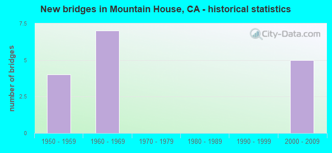
- New bridges - historical statistics
- 41950-1959
- 71960-1969
- 52000-2009

- Reconstructed bridges - Historical Statistics
- 31990-1999
- 12000-2009


- Bridge Condition - Deck
- 25.0%Good
- 33.3%Fair
- 41.7%Poor

- Bridge Condition - Superstructure
- 66.7%Good
- 16.7%Fair
- 16.7%Poor

- Bridge Condition - Substructure
- 75.0%Good
- 16.7%Fair
- 8.3%Poor

- Bridge Condition - Channel
- 50.0%Excellent
- 50.0%Very good
Find on map >> Show street view
Structure Number: 28C0402, Location: 100 FT S HERDLYN RD (Lat: 37.815689, Lng: -121.561164), Route carried "on" structure: County highway , Year Built: 1950, Status: Posted for load, Structure Length: 8.90m (29.20ft), Average Daily Traffic: 150 (year 2013), Truck Traffic: 1%, Average Future Daily Traffic: 367 (year 2038), Design Load: HS 15, Features Intersected: DELTA-MENDOTA CANAL, Facility Carried by Structure: LINDEMANN RD
Minimum Vertical Clearance: 30+ m (98+ ft), Kilometerpoint: 0.000, Lanes on structure: 2, Owner: County Highway Agency, Approaching Roadway Width: 6.1m (20.0ft), Material/Design: Wood or Timber, Design/Construction: Stringer/Multi-beam, Number Of Spans In Main Unit: 11, Length of Maximum Span: 8.2m (26.9ft), Curb or Sidewalk Widths: Left: 0.6m (2.0ft), Right: 0.6m (2.0ft), Curb-To-Curb Width: 6.7m (22.0ft), Out-to-Out Width: 7.9m (25.9ft)
Condition: Deck: Fair, Superstructure: Fair, Substructure: Poor, Channel: Excellent, Operating Rating: 21.1 metric tons, Method Used To Determine Operating Rating: Allowable Stress (AS), Inventory Rating: 10.4 metric tons, Method Used To Determine Inventory Rating: Allowable Stress (AS), Structural Evaluation: High priority of replacement, Deck Geometry: Meets minimum limits, Waterway Adequacy: Equal to present desirable criteria, Approach Roadway Alignment: Equal to present minimum criteria, Bridge Posting: Required (Relationship of Operating Rating to Maximum Legal Load: 0.1 - 9.9% below), Length Of Structure Improvement: 8.90m (29.20ft), Designated Inspection Frequency: Every 12 months, Underwater Inspection Frequency: Every 60 months, Inspection Date: July 2021, Underwater Inspection Date: May 2019, Bridge Improvement Cost: $1,616,000, Deck Structure Type: Concrete Cast-file-Place
Find on map >> Show street view
Structure Number: 29 0037, Location: 10-SJ-205-0.15 (Lat: 37.743219, Lng: -121.553736), Route carried "on" structure: Interstate 205, Year Built: 1953, Year Reconstructed: 1998, Status: Open, Structure Length: 4.78m (15.68ft), Average Daily Traffic: 106,000 (year 2009), Truck Traffic: 12%, Average Future Daily Traffic: 169,162 (year 2040), Design Load: HS 20, Features Intersected: DELTA-MENDOTA CANAL
Minimum Vertical Clearance: 30+ m (98+ ft), Kilometerpoint: 0.150, Lanes on structure: 6, Base Highway Network: Yes (Inventory Route: 2, Subroute: 1), Owner: State Highway Agency, Approaching Roadway Width: 33.9m (111.2ft), Skew: 33 degrees, Material/Design: Concrete continuous, Design/Construction: Tee Beam, Number Of Spans In Main Unit: 3, Length of Maximum Span: 18.3m (60.0ft), Curb-To-Curb Width: 33.9m (111.2ft), Out-to-Out Width: 35.3m (115.8ft)
Condition: Deck: Fair, Superstructure: Fair, Substructure: Fair, Channel: Excellent, Operating Rating: 33.7 metric tons, Method Used To Determine Operating Rating: Load and Resistance Factor Rating (LRFR) rating reported by rating factor(RF) method using HL-93 loadings, Inventory Rating: 22.0 metric tons, Method Used To Determine Inventory Rating: Load and Resistance Factor Rating (LRFR) rating reported by rating factor(RF) method using HL-93 loadings, Structural Evaluation: Somewhat better than minimum adequacy, Deck Geometry: Superior to present desirable criteria, Waterway Adequacy: Superior to present desirable criteria, Approach Roadway Alignment: Equal to present desirable criteria, Designated Inspection Frequency: Every 24 months, Underwater Inspection Frequency: Every 72 months, Inspection Date: March 2020, Underwater Inspection Date: May 2020, Deck Structure Type: Concrete Cast-file-Place, Wearing Surface/Protective System: Wearing Surface: Bituminous
Find on map >> Show street view
Structure Number: 29 0299, Location: 10-SJ-205-L0.01 (Lat: 37.742950, Lng: -121.557294), Route carried "on" structure: Interstate 205, Year Built: 1966, Year Reconstructed: 1999, Status: Open, Structure Length: 2.26m (7.41ft), Average Daily Traffic: 106,000 (year 2009), Truck Traffic: 12%, Average Future Daily Traffic: 169,162 (year 2040), Design Load: HS 20, Features Intersected: AQUEDUCT SERVICE RD
Minimum Vertical Clearance: 30+ m (98+ ft), Kilometerpoint: 0.010, Lanes on structure: 6, Lanes under structure: 1, Base Highway Network: Yes (Inventory Route: 2, Subroute: 1), Owner: State Highway Agency, Approaching Roadway Width: 33.9m (111.2ft), Skew: 30 degrees, Material/Design: Concrete continuous, Design/Construction: Slab, Number Of Spans In Main Unit: 3, Length of Maximum Span: 9.1m (29.9ft), Curb-To-Curb Width: 33.9m (111.2ft), Out-to-Out Width: 35.3m (115.8ft)
Condition: Deck: Good, Superstructure: Good, Substructure: Good, Operating Rating: 54.1 metric tons, Method Used To Determine Operating Rating: Assigned rating based on Load Factor Design (LFD) reported in metric tons, Inventory Rating: 32.4 metric tons, Method Used To Determine Inventory Rating: Assigned rating based on Load Factor Design (LFD) reported in metric tons, Structural Evaluation: Better than present minimum criteria, Deck Geometry: Superior to present desirable criteria, Underclear: High priority of corrective action, Approach Roadway Alignment: Equal to present desirable criteria, Designated Inspection Frequency: Every 48 months, Inspection Date: March 2020, Deck Structure Type: Concrete Cast-file-Place, Wearing Surface/Protective System: Wearing Surface: Integral Concrete
Find on map >> Show street view
Structure Number: 29 0321, Location: 10-SJ-205-1.36 (Lat: 37.742936, Lng: -121.531811), Route carried "on" structure: Bypass County highway , Year Built: 2007, Status: Open, Structure Length: 8.20m (26.90ft), Average Daily Traffic: 7,819 (year 2007), Truck Traffic: 8%, Average Future Daily Traffic: 8,608 (year 2042), Design Load: HS 20+Mod, Features Intersected: INTERSTATE ROUTE 205, Facility Carried by Structure: MOUNTAINHOUSE PKWY
Minimum Vertical Clearance: 30+ m (98+ ft), Kilometerpoint: 0.000, Lanes on structure: 6, Lanes under structure: 6, Owner: State Highway Agency, Approaching Roadway Width: 29.7m (97.4ft), Skew: 30 degrees, Material/Design: Prestressed concrete continuous, Design/Construction: Box Beam or Girders - Multiple, Number Of Spans In Main Unit: 2, Length of Maximum Span: 41.0m (134.5ft), Curb or Sidewalk Widths: Left: 0.0m, Right: 1.5m (4.9ft), Curb-To-Curb Width: 29.7m (97.4ft), Out-to-Out Width: 32.6m (107.0ft)
Condition: Deck: Good, Superstructure: Good, Substructure: Good, Operating Rating: 63.5 metric tons, Method Used To Determine Operating Rating: Load and Resistance Factor Rating (LRFR) rating reported by rating factor(RF) method using HL-93 loadings, Inventory Rating: 43.7 metric tons, Method Used To Determine Inventory Rating: Load and Resistance Factor Rating (LRFR) rating reported by rating factor(RF) method using HL-93 loadings, Structural Evaluation: Better than present minimum criteria, Deck Geometry: Superior to present desirable criteria, Underclear: Somewhat better than minimum adequacy, Approach Roadway Alignment: Equal to present desirable criteria, Designated Inspection Frequency: Every 24 months, Inspection Date: March 2020, Deck Structure Type: Concrete Cast-file-Place
Find on map >> Show street view
Structure Number: 29C0421, Location: 0.6 MI EAST OF BYRON ROAD (Lat: 37.780278, Lng: -121.517575), Route carried "on" structure: County highway , Year Built: 2005, Status: Open, Structure Length: 3.34m (10.96ft), Average Daily Traffic: 271 (year 2013), Truck Traffic: 5%, Average Future Daily Traffic: 571 (year 2040), Design Load: HS 20+Mod, Features Intersected: W. SIDE IRRIGATION CANAL, Facility Carried by Structure: BETHANY ROAD
Minimum Vertical Clearance: 30+ m (98+ ft), Kilometerpoint: 0.000, Lanes on structure: 2, Owner: County Highway Agency, Approaching Roadway Width: 9.7m (31.8ft), Material/Design: Prestressed concrete, Design/Construction: Stringer/Multi-beam, Number Of Spans In Main Unit: 1, Length of Maximum Span: 32.9m (107.9ft), Curb-To-Curb Width: 9.8m (32.2ft), Out-to-Out Width: 10.8m (35.4ft)
Condition: Deck: Fair, Superstructure: Good, Substructure: Good, Channel: Very good, Operating Rating: 54.1 metric tons, Method Used To Determine Operating Rating: Assigned rating based on Load Factor Design (LFD) reported in metric tons, Inventory Rating: 32.4 metric tons, Method Used To Determine Inventory Rating: Assigned rating based on Load Factor Design (LFD) reported in metric tons, Structural Evaluation: Better than present minimum criteria, Deck Geometry: Better than present minimum criteria, Waterway Adequacy: Equal to present minimum criteria, Approach Roadway Alignment: Equal to present desirable criteria, Designated Inspection Frequency: Every 24 months, Inspection Date: September 2020, Deck Structure Type: Concrete Cast-file-Place
Find on map >> Show street view
Structure Number: 33 0195, Location: 04-ALA-580-L0.92L (Lat: 37.742167, Lng: -121.572275), Route carried "on" structure: Interstate 580, Year Built: 1953, Year Reconstructed: 2005, Status: Open, Structure Length: 3.13m (10.27ft), Average Daily Traffic: 176,000 (year 2020), Average Future Daily Traffic: 229,025 (year 2042), Design Load: HS 20, Features Intersected: MIDWAY ROAD
Minimum Vertical Clearance: 30+ m (98+ ft), Kilometerpoint: 0.920, Lanes on structure: 10, Lanes under structure: 2, Base Highway Network: Yes (Inventory Route: 5, Subroute: 1), Owner: State Highway Agency, Approaching Roadway Width: 54.4m (178.5ft), Skew: 31 degrees, Material/Design: Concrete continuous, Design/Construction: Slab, Number Of Spans In Main Unit: 3, Length of Maximum Span: 12.2m (40.0ft), Curb-To-Curb Width: 54.4m (178.5ft), Out-to-Out Width: 55.7m (182.7ft)
Condition: Deck: Good, Superstructure: Good, Substructure: Good, Operating Rating: 54.1 metric tons, Method Used To Determine Operating Rating: Assigned rating based on Load Factor Design (LFD) reported in metric tons, Inventory Rating: 32.4 metric tons, Method Used To Determine Inventory Rating: Assigned rating based on Load Factor Design (LFD) reported in metric tons, Structural Evaluation: Better than present minimum criteria, Deck Geometry: Superior to present desirable criteria, Underclear: Somewhat better than minimum adequacy, Approach Roadway Alignment: Equal to present desirable criteria, Designated Inspection Frequency: Every 24 months, Inspection Date: January 2022, Deck Structure Type: Concrete Cast-file-Place, Wearing Surface/Protective System: Wearing Surface: Integral Concrete
Find on map >> Show street view
Structure Number: 33 0196L, Location: 04-ALA-580-R1.48 (Lat: 37.740428, Lng: -121.585594), Route carried "on" structure: Interstate 580, Year Built: 1953, Status: Open, Structure Length: 4.20m (13.78ft), Average Daily Traffic: 87,500 (year 2020), Truck Traffic: 13%, Average Future Daily Traffic: 115,476 (year 2044), Design Load: HS 20, Features Intersected: GRANT LINE ROAD
Minimum Vertical Clearance: 30+ m (98+ ft), Kilometerpoint: 1.480, Lanes on structure: 4, Lanes under structure: 2, Base Highway Network: Yes (Inventory Route: 5, Subroute: 1), Owner: State Highway Agency, Approaching Roadway Width: 20.1m (65.9ft), Skew: 2 degrees, Material/Design: Concrete continuous, Design/Construction: Slab, Number Of Spans In Main Unit: 3, Length of Maximum Span: 13.7m (44.9ft), Curb-To-Curb Width: 23.7m (77.8ft), Out-to-Out Width: 24.3m (79.7ft)
Condition: Deck: Poor, Superstructure: Poor, Substructure: Good, Operating Rating: 74.2 metric tons, Method Used To Determine Operating Rating: Load Factor (LF), Inventory Rating: 44.7 metric tons, Method Used To Determine Inventory Rating: Load Factor (LF), Structural Evaluation: Meets minimum limits, Deck Geometry: Superior to present desirable criteria, Underclear: Meets minimum limits, Approach Roadway Alignment: Equal to present desirable criteria, Length Of Structure Improvement: 4.20m (13.78ft), Designated Inspection Frequency: Every 24 months, Inspection Date: January 2022, Bridge Improvement Cost: $1,022,000, Roadway Improvement Cost: $204,000, Total Project Cost: $1,716,000 ( Estimate for 2020), Deck Structure Type: Concrete Cast-file-Place
Find on map >> Show street view
Structure Number: 33 0196R, Location: 04-ALA-580-R1.48 (Lat: 37.740711, Lng: -121.585500), Route carried "on" structure: Interstate 580, Year Built: 1969, Year Reconstructed: 1998, Status: Open, Structure Length: 4.48m (14.70ft), Average Daily Traffic: 87,500 (year 2020), Truck Traffic: 13%, Average Future Daily Traffic: 115,476 (year 2044), Design Load: HS 20, Features Intersected: GRANT LINE ROAD
Minimum Vertical Clearance: 30+ m (98+ ft), Kilometerpoint: 1.480, Lanes on structure: 5, Lanes under structure: 2, Base Highway Network: Yes (Inventory Route: 5, Subroute: 1), Owner: State Highway Agency, Approaching Roadway Width: 23.4m (76.8ft), Skew: 2 degrees, Material/Design: Concrete continuous, Design/Construction: Box Beam or Girders - Multiple, Number Of Spans In Main Unit: 3, Length of Maximum Span: 14.6m (47.9ft), Curb-To-Curb Width: 23.4m (76.8ft), Out-to-Out Width: 24.2m (79.4ft)
Condition: Deck: Poor, Superstructure: Good, Substructure: Good, Operating Rating: 79.1 metric tons, Method Used To Determine Operating Rating: Load Factor (LF), Inventory Rating: 47.6 metric tons, Method Used To Determine Inventory Rating: Load Factor (LF), Structural Evaluation: Better than present minimum criteria, Deck Geometry: Equal to present minimum criteria, Underclear: Meets minimum limits, Approach Roadway Alignment: Equal to present desirable criteria, Designated Inspection Frequency: Every 24 months, Inspection Date: January 2022, Deck Structure Type: Concrete Cast-file-Place
Find on map >> Show street view
Structure Number: 33 0345R, Location: 04-ALA-580-L1.04R (Lat: 37.742361, Lng: -121.572350), Route carried "on" structure: Interstate 580, Year Built: 1966, Status: Open, Structure Length: 2.96m (9.71ft), Average Daily Traffic: 29,333 (year 2020), Truck Traffic: 13%, Average Future Daily Traffic: 87,725 (year 2039), Design Load: HS 20, Features Intersected: MIDWAY ROAD
Minimum Vertical Clearance: 30+ m (98+ ft), Kilometerpoint: 1.040, Lanes on structure: 2, Lanes under structure: 2, Base Highway Network: Yes (Inventory Route: 5, Subroute: 1), Owner: State Highway Agency, Approaching Roadway Width: 13.1m (43.0ft), Material/Design: Concrete continuous, Design/Construction: Slab, Number Of Spans In Main Unit: 3, Length of Maximum Span: 12.2m (40.0ft), Curb-To-Curb Width: 11.9m (39.0ft), Out-to-Out Width: 12.6m (41.3ft)
Condition: Deck: Poor, Superstructure: Poor, Substructure: Good, Operating Rating: 72.6 metric tons, Method Used To Determine Operating Rating: Load Factor (LF), Inventory Rating: 43.7 metric tons, Method Used To Determine Inventory Rating: Load Factor (LF), Structural Evaluation: Meets minimum limits, Deck Geometry: Equal to present minimum criteria, Underclear: Equal to present minimum criteria, Approach Roadway Alignment: Equal to present desirable criteria, Length Of Structure Improvement: 2.96m (9.71ft), Designated Inspection Frequency: Every 24 months, Inspection Date: January 2022, Bridge Improvement Cost: $374,000, Roadway Improvement Cost: $74,000, Total Project Cost: $628,000 ( Estimate for 2020), Deck Structure Type: Concrete Cast-file-Place
Find on map >> Show street view
Structure Number: 33 0346R, Location: 04-ALA-580-0.39R (Lat: 37.742506, Lng: -121.561169), Route carried "on" structure: Interstate 580, Year Built: 1966, Status: Open, Structure Length: 9.07m (29.76ft), Average Daily Traffic: 17,900 (year 2020), Truck Traffic: 13%, Average Future Daily Traffic: 64,957 (year 2042), Design Load: HS 20+Mod, Features Intersected: INTERSTATE 205
Minimum Vertical Clearance: 30+ m (98+ ft), Kilometerpoint: 0.390, Lanes on structure: 2, Lanes under structure: 6, Base Highway Network: Yes (Inventory Route: 5, Subroute: 1), Owner: State Highway Agency, Approaching Roadway Width: 11.9m (39.0ft), Skew: 9 degrees, Material/Design: Steel continuous, Design/Construction: Stringer/Multi-beam, Number Of Spans In Main Unit: 2, Length of Maximum Span: 46.5m (152.6ft), Curb-To-Curb Width: 11.9m (39.0ft), Out-to-Out Width: 12.6m (41.3ft)
Condition: Deck: Poor, Superstructure: Good, Substructure: Good, Operating Rating: 43.7 metric tons, Method Used To Determine Operating Rating: Load and Resistance Factor Rating (LRFR) rating reported by rating factor(RF) method using HL-93 loadings, Inventory Rating: 33.7 metric tons, Method Used To Determine Inventory Rating: Load and Resistance Factor Rating (LRFR) rating reported by rating factor(RF) method using HL-93 loadings, Structural Evaluation: Better than present minimum criteria, Deck Geometry: Equal to present minimum criteria, Underclear: High priority of corrective action, Approach Roadway Alignment: Equal to present desirable criteria, Designated Inspection Frequency: Every 24 months, Other Special Inspection Frequency: Every 48 months, Inspection Date: January 2022, Other Special Inspection Date: Febuary 2022, Deck Structure Type: Concrete Cast-file-Place
Find on map >> Show street view
Structure Number: 33 0693R, Location: 04-ALA-580-0.40R (Lat: 37.742014, Lng: -121.561319), Route carried "on" structure: Interstate 580, Year Built: 2009, Status: Open, Structure Length: 37.30m (122.38ft), Average Daily Traffic: 17,900 (year 2020), Truck Traffic: 13%, Average Future Daily Traffic: 63,461 (year 2039), Design Load: HS 20+Mod, Features Intersected: INTERSTATE 205 EB
Minimum Vertical Clearance: 30+ m (98+ ft), Kilometerpoint: 0.400, Lanes on structure: 2, Lanes under structure: 3, Base Highway Network: Yes (Inventory Route: 5, Subroute: 1), Owner: State Highway Agency, Approaching Roadway Width: 11.7m (38.4ft), Material/Design: Prestressed concrete continuous, Design/Construction: Box Beam or Girders - Multiple, Number Of Spans In Main Unit: 7, Length of Maximum Span: 60.0m (196.9ft), Curb-To-Curb Width: 11.7m (38.4ft), Out-to-Out Width: 12.6m (41.3ft)
Condition: Deck: Fair, Superstructure: Good, Substructure: Good, Operating Rating: 54.1 metric tons, Method Used To Determine Operating Rating: Assigned rating based on Load Factor Design (LFD) reported in metric tons, Inventory Rating: 32.4 metric tons, Method Used To Determine Inventory Rating: Assigned rating based on Load Factor Design (LFD) reported in metric tons, Structural Evaluation: Better than present minimum criteria, Deck Geometry: Equal to present minimum criteria, Underclear: Equal to present minimum criteria, Approach Roadway Alignment: Equal to present desirable criteria, Designated Inspection Frequency: Every 24 months, Inspection Date: January 2022, Deck Structure Type: Concrete Cast-file-Place
Find on map >> Show street view
Structure Number: 33C0127, Location: 0.1 MI NE OF I-580 (Lat: 37.750617, Lng: -121.576042), Route carried "on" structure: County highway , Year Built: 1963, Status: Open, Structure Length: 4.69m (15.39ft), Average Daily Traffic: 1,000 (year 2010), Truck Traffic: 25%, Average Future Daily Traffic: 2,040 (year 2041), Design Load: HS 20, Features Intersected: CALIFORNIA AQUEDUCT, Facility Carried by Structure: GRANT LINE RD
Minimum Vertical Clearance: 30+ m (98+ ft), Kilometerpoint: 0.000, Lanes on structure: 2, Owner: Local Agency, Approaching Roadway Width: 12.2m (40.0ft), Material/Design: Prestressed concrete, Design/Construction: Stringer/Multi-beam, Number Of Spans In Main Unit: 2, Length of Maximum Span: 24.1m (79.1ft), Curb or Sidewalk Widths: Left: 0.0m, Right: 1.5m (4.9ft), Curb-To-Curb Width: 9.0m (29.5ft), Out-to-Out Width: 11.3m (37.1ft)
Condition: Deck: Poor, Superstructure: Good, Substructure: Fair, Channel: Very good, Operating Rating: 50.5 metric tons, Method Used To Determine Operating Rating: Load and Resistance Factor Rating (LRFR) rating reported by rating factor(RF) method using HL-93 loadings, Inventory Rating: 32.7 metric tons, Method Used To Determine Inventory Rating: Load and Resistance Factor Rating (LRFR) rating reported by rating factor(RF) method using HL-93 loadings, Structural Evaluation: Somewhat better than minimum adequacy, Deck Geometry: Somewhat better than minimum adequacy, Waterway Adequacy: Superior to present desirable criteria, Approach Roadway Alignment: Better than present minimum criteria, Length Of Structure Improvement: 4.69m (15.39ft), Designated Inspection Frequency: Every 24 months, Underwater Inspection Frequency: Every 72 months, Inspection Date: November 2021, Underwater Inspection Date: Febuary 2018, Bridge Improvement Cost: $530,000, Roadway Improvement Cost: $106,000, Total Project Cost: $890,000 ( Estimate for 2018), Deck Structure Type: Concrete Cast-file-Place
Find on map >> Show street view
Structure Number: 29 0299, Location: 10-SJ-205-L0.01 (Lat: 37.742950, Lng: -121.557294), Route carried "under" structure: State lands road , Year Built: 1966, Structure Length: 0. m, Average Daily Traffic: 1 (year 1998), Features Intersected: AQUEDUCT SERVICE RD, Facility Carried by Structure: INTERSTATE 205
Minimum Vertical Clearance: 4.34m (14.24ft), Kilometerpoint: 0.000, Lanes on structure: 6, Lanes under structure: 1, Material/Design: Concrete continuous, Design/Construction: Slab, Length of Maximum Span: 9.1m (29.9ft)
Find on map >> Show street view
Structure Number: 29 0321, Location: 10-SJ-205-1.36 (Lat: 37.742936, Lng: -121.531811), Route carried "under" structure: Interstate 205, Year Built: 2007, Structure Length: 0. m, Average Daily Traffic: 106,000 (year 2009), Truck Traffic: 12%, Features Intersected: INTERSTATE ROUTE 205, Facility Carried by Structure: MOUNTAINHOUSE PKWY
Minimum Vertical Clearance: 5.71m (18.73ft), Kilometerpoint: 1.360, Lanes on structure: 6, Lanes under structure: 6, Material/Design: Prestressed concrete continuous, Design/Construction: Box Beam or Girders - Multiple, Length of Maximum Span: 41.0m (134.5ft)
Find on map >> Show street view
Structure Number: 33 0346R, Location: 04-ALA-580-0.39R (Lat: 37.742506, Lng: -121.561169), Route carried "under" structure: Interstate 205, Year Built: 1966, Structure Length: 0. m, Average Daily Traffic: 122,000 (year 2020), Truck Traffic: 12%, Features Intersected: INTERSTATE 205, Facility Carried by Structure: INTERSTATE 580 WB
Minimum Vertical Clearance: 5.15m (16.90ft), Kilometerpoint: 0.220, Lanes on structure: 2, Lanes under structure: 6, Material/Design: Steel continuous, Design/Construction: Stringer/Multi-beam, Length of Maximum Span: 46.5m (152.6ft)
Find on map >> Show street view
Structure Number: 33 0693R, Location: 04-ALA-580-0.40R (Lat: 37.742014, Lng: -121.561319), Route carried "under" structure: Interstate 205, Year Built: 2009, Structure Length: 0. m, Average Daily Traffic: 122,000 (year 2020), Truck Traffic: 12%, Features Intersected: INTERSTATE 205 EB, Facility Carried by Structure: INTERSTATE 580 WB
Minimum Vertical Clearance: 6.27m (20.57ft), Kilometerpoint: 0.220, Lanes on structure: 2, Lanes under structure: 3, Material/Design: Prestressed concrete continuous, Design/Construction: Box Beam or Girders - Multiple, Length of Maximum Span: 60.0m (196.9ft)