Bridge Statistics for Mount Sterling, Kentucky (KY)
Condition, Traffic, Stress, Structural Evaluation, Project Costs
- National Bridge Inventory (NBI) Statistics
- 41Number of bridges
- 292ft / 89.5mTotal length
- $2,102,000Total costs
- 261,994Total average daily traffic
- 33,494Total average daily truck traffic
- National Bridge Inventory (NBI) Registered Bridges for Mount Sterling
- No street view available for this location
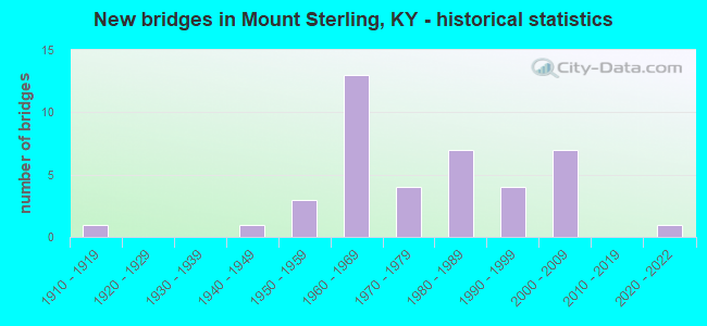
- New bridges - historical statistics
- 11910-1919
- 11940-1949
- 31950-1959
- 131960-1969
- 41970-1979
- 71980-1989
- 41990-1999
- 72000-2009
- 12020-2022


- Bridge Condition - Deck
- 10.3%Very good
- 31.0%Good
- 44.8%Satisfactory
- 13.8%Fair

- Bridge Condition - Superstructure
- 13.8%Very good
- 44.8%Good
- 27.6%Satisfactory
- 13.8%Fair

- Bridge Condition - Substructure
- 48.3%Good
- 31.0%Satisfactory
- 20.7%Fair

- Bridge Condition - Channel
- 7.4%Very good
- 14.8%Good
- 48.1%Satisfactory
- 25.9%Fair
- 3.7%Poor

- Bridge Condition - Culverts
- 75.0%Satisfactory
- 25.0%Fair
Find on map >> Show street view
Structure Number: 87B00011N, Location: 1.4 MI W OF N-JCT KY 11 (Lat: 38.094722, Lng: -83.973611), Route carried "on" structure: US 460, Year Built: 1953, Status: Posted for load, Structure Length: 3.02m (9.91ft), Average Daily Traffic: 1,882 (year 2020), Truck Traffic: 14%, Average Future Daily Traffic: 1,562 (year 2040), Design Load: H 20, Features Intersected: SOMERSET CREEK
Minimum Vertical Clearance: 30+ m (98+ ft), Kilometerpoint: 9.471, Lanes on structure: 2, Base Highway Network: Yes, Owner: State Highway Agency, Approaching Roadway Width: 7.3m (24.0ft), Material/Design: Concrete, Design/Construction: Tee Beam, Number Of Spans In Main Unit: 3, Length of Maximum Span: 9.1m (29.9ft), Curb-To-Curb Width: 7.3m (24.0ft), Out-to-Out Width: 8.5m (27.9ft)
Condition: Deck: Satisfactory, Superstructure: Fair, Substructure: Fair, Channel: Satisfactory, Operating Rating: 57.8 metric tons, Method Used To Determine Operating Rating: Load Factor (LF), Inventory Rating: 34.7 metric tons, Method Used To Determine Inventory Rating: Load Factor (LF), Structural Evaluation: Somewhat better than minimum adequacy, Deck Geometry: Meets minimum limits, Waterway Adequacy: Equal to present desirable criteria, Approach Roadway Alignment: Better than present minimum criteria, Bridge Posting: Required (Relationship of Operating Rating to Maximum Legal Load: 10.0 - 19.9% below), Designated Inspection Frequency: Every 24 months, Inspection Date: July 2021, Deck Structure Type: Concrete Cast-file-Place, Wearing Surface/Protective System: Wearing Surface: Latex Concrete
Find on map >> Show street view
Structure Number: 87B00012N, Location: 3.6 MI W OF N-JCT KY 11 (Lat: 38.102778, Lng: -84.011667), Route carried "on" structure: US 460, Year Built: 1953, Status: Posted for load, Structure Length: 3.05m (10.01ft), Average Daily Traffic: 1,862 (year 2019), Truck Traffic: 14%, Average Future Daily Traffic: 1,545 (year 2039), Design Load: H 20, Features Intersected: GRASSY LICK CREEK
Minimum Vertical Clearance: 30+ m (98+ ft), Kilometerpoint: 5.816, Lanes on structure: 2, Base Highway Network: Yes, Owner: State Highway Agency, Approaching Roadway Width: 7.0m (23.0ft), Material/Design: Concrete, Design/Construction: Tee Beam, Number Of Spans In Main Unit: 3, Length of Maximum Span: 9.1m (29.9ft), Curb-To-Curb Width: 7.3m (24.0ft), Out-to-Out Width: 8.5m (27.9ft)
Condition: Deck: Satisfactory, Superstructure: Fair, Substructure: Fair, Channel: Fair, Operating Rating: 59.3 metric tons, Method Used To Determine Operating Rating: Load Factor (LF), Inventory Rating: 35.7 metric tons, Method Used To Determine Inventory Rating: Load Factor (LF), Structural Evaluation: Somewhat better than minimum adequacy, Deck Geometry: Meets minimum limits, Waterway Adequacy: Better than present minimum criteria, Approach Roadway Alignment: Better than present minimum criteria, Bridge Posting: Required (Relationship of Operating Rating to Maximum Legal Load: 10.0 - 19.9% below), Designated Inspection Frequency: Every 24 months, Inspection Date: July 2021, Deck Structure Type: Concrete Cast-file-Place, Wearing Surface/Protective System: Wearing Surface: Latex Concrete
Find on map >> Show street view
Structure Number: 87B00022N, Location: 2.2 MI W OF US 460 NTRCH (Lat: 38.073333, Lng: -83.992222), Route carried "on" structure: State highway 713, Year Built: 1960, Status: Open, Structure Length: 9.39m (30.81ft), Average Daily Traffic: 1,191 (year 2020), Truck Traffic: 6%, Average Future Daily Traffic: 1,048 (year 2040), Design Load: H 20, Features Intersected: I-64 UNDR KY 713, Facility Carried by Structure: GRASSY LICK ROAD
Minimum Vertical Clearance: 30+ m (98+ ft), Kilometerpoint: 5.570, Lanes on structure: 2, Lanes under structure: 4, Owner: State Highway Agency, Approaching Roadway Width: 7.6m (24.9ft), Skew: 4 degrees, Material/Design: Concrete continuous, Design/Construction: Tee Beam, Number Of Spans In Main Unit: 4, Length of Maximum Span: 26.2m (86.0ft), Curb or Sidewalk Widths: Left: 0.8m (2.6ft), Right: 0.8m (2.6ft), Curb-To-Curb Width: 8.0m (26.2ft), Out-to-Out Width: 10.2m (33.5ft)
Condition: Deck: Satisfactory, Superstructure: Good, Substructure: Satisfactory, Operating Rating: 51.6 metric tons, Method Used To Determine Operating Rating: Load Factor (LF), Inventory Rating: 31.0 metric tons, Method Used To Determine Inventory Rating: Load Factor (LF), Structural Evaluation: Equal to present minimum criteria, Deck Geometry: Meets minimum limits, Underclear: High priority of corrective action, Approach Roadway Alignment: Equal to present minimum criteria, Designated Inspection Frequency: Every 24 months, Inspection Date: July 2021, Deck Structure Type: Concrete Cast-file-Place, Wearing Surface/Protective System: Wearing Surface: Monolithic Concrete
Find on map >> Show street view
Structure Number: 87B00023N, Location: 1.0 MI E. OF I-64 OP (Lat: 38.065833, Lng: -83.974444), Route carried "on" structure: State highway 713, Year Built: 1968, Status: Open, Structure Length: 3.63m (11.91ft), Average Daily Traffic: 1,191 (year 2020), Truck Traffic: 6%, Average Future Daily Traffic: 1,048 (year 2040), Design Load: H 20, Features Intersected: SOMERSET CREEK, Facility Carried by Structure: GRASSY LICK ROAD
Minimum Vertical Clearance: 30+ m (98+ ft), Kilometerpoint: 7.376, Lanes on structure: 2, Owner: State Highway Agency, Approaching Roadway Width: 7.6m (24.9ft), Skew: 4 degrees, Material/Design: Concrete, Design/Construction: Tee Beam, Number Of Spans In Main Unit: 3, Length of Maximum Span: 11.7m (38.4ft), Curb or Sidewalk Widths: Left: 0.3m (1.0ft), Right: 0.3m (1.0ft), Curb-To-Curb Width: 7.5m (24.6ft), Out-to-Out Width: 8.2m (26.9ft)
Condition: Deck: Good, Superstructure: Satisfactory, Substructure: Fair, Channel: Satisfactory, Operating Rating: 94.3 metric tons, Method Used To Determine Operating Rating: Load Factor (LF), Inventory Rating: 56.6 metric tons, Method Used To Determine Inventory Rating: Load Factor (LF), Structural Evaluation: Somewhat better than minimum adequacy, Deck Geometry: Meets minimum limits, Waterway Adequacy: Equal to present desirable criteria, Approach Roadway Alignment: Equal to present minimum criteria, Designated Inspection Frequency: Every 24 months, Inspection Date: July 2021, Deck Structure Type: Concrete Cast-file-Place, Wearing Surface/Protective System: Wearing Surface: Latex Concrete
Find on map >> Show street view
Structure Number: 87B00024L, Location: WBL 1.2 MI E OF CLARK CL (Lat: 38.063611, Lng: -84.020556), Route carried "on" structure: Interstate 64, Year Built: 1960, Status: Open, Structure Length: 4.86m (15.94ft), Average Daily Traffic: 13,098 (year 2019), Truck Traffic: 19%, Average Future Daily Traffic: 15,980 (year 2039), Design Load: HS 20, Features Intersected: PREWITT-GRASSY LICK RD
Minimum Vertical Clearance: 30+ m (98+ ft), Kilometerpoint: 169.890, Lanes on structure: 2, Lanes under structure: 2, Base Highway Network: Yes, Owner: State Highway Agency, Approaching Roadway Width: 11.0m (36.1ft), Skew: 2 degrees, Material/Design: Concrete, Design/Construction: Tee Beam, Number Of Spans In Main Unit: 3, Length of Maximum Span: 15.1m (49.5ft), Curb-To-Curb Width: 9.3m (30.5ft), Out-to-Out Width: 11.4m (37.4ft)
Condition: Deck: Satisfactory, Superstructure: Satisfactory, Substructure: Satisfactory, Operating Rating: 88.5 metric tons, Method Used To Determine Operating Rating: Load Factor (LF), Inventory Rating: 53.2 metric tons, Method Used To Determine Inventory Rating: Load Factor (LF), Structural Evaluation: Equal to present minimum criteria, Deck Geometry: High priority of replacement, Underclear: Somewhat better than minimum adequacy, Approach Roadway Alignment: Better than present minimum criteria, Length Of Structure Improvement: 0.48m (1.57ft), Designated Inspection Frequency: Every 24 months, Inspection Date: July 2021, Bridge Improvement Cost: $704,000, Total Project Cost: $703,000, Deck Structure Type: Concrete Cast-file-Place, Wearing Surface/Protective System: Wearing Surface: Latex Concrete
Find on map >> Show street view
Structure Number: 87B00024R, Location: EBL 1.2 MI E OF CLARK CL (Lat: 38.063333, Lng: -84.020556), Route carried "on" structure: Interstate 64, Year Built: 1960, Status: Open, Structure Length: 4.86m (15.94ft), Average Daily Traffic: 13,098 (year 2019), Truck Traffic: 19%, Average Future Daily Traffic: 15,980 (year 2039), Design Load: HS 20, Features Intersected: PREWITT-GRASSY LICK RD
Minimum Vertical Clearance: 30+ m (98+ ft), Kilometerpoint: 169.890, Lanes on structure: 2, Lanes under structure: 2, Base Highway Network: Yes, Owner: State Highway Agency, Approaching Roadway Width: 11.0m (36.1ft), Skew: 2 degrees, Material/Design: Concrete, Design/Construction: Tee Beam, Number Of Spans In Main Unit: 3, Length of Maximum Span: 15.1m (49.5ft), Curb-To-Curb Width: 9.3m (30.5ft), Out-to-Out Width: 11.4m (37.4ft)
Condition: Deck: Fair, Superstructure: Satisfactory, Substructure: Fair, Operating Rating: 88.5 metric tons, Method Used To Determine Operating Rating: Load Factor (LF), Inventory Rating: 53.2 metric tons, Method Used To Determine Inventory Rating: Load Factor (LF), Structural Evaluation: Somewhat better than minimum adequacy, Deck Geometry: High priority of replacement, Underclear: Superior to present desirable criteria, Approach Roadway Alignment: Better than present minimum criteria, Length Of Structure Improvement: 0.48m (1.57ft), Designated Inspection Frequency: Every 24 months, Inspection Date: July 2021, Bridge Improvement Cost: $704,000, Total Project Cost: $703,000, Deck Structure Type: Concrete Cast-file-Place, Wearing Surface/Protective System: Wearing Surface: Latex Concrete
Find on map >> Show street view
Structure Number: 87B00026N, Location: 1.0 MI WEST OF KY 11 NTRC (Lat: 38.074444, Lng: -83.970556), Route carried "on" structure: Interstate 64, Year Built: 1960, Status: Open, Structure Length: 1.28m (4.20ft), Average Daily Traffic: 26,196 (year 2019), Truck Traffic: 19%, Average Future Daily Traffic: 31,959 (year 2039), Design Load: HS 20, Features Intersected: SOMERSET CREEK
Minimum Vertical Clearance: 30+ m (98+ ft), Kilometerpoint: 174.532, Lanes on structure: 4, Base Highway Network: Yes, Owner: State Highway Agency, Approaching Roadway Width: 22.6m (74.1ft), Skew: 23 degrees, Material/Design: Concrete, Design/Construction: Culvert, Number Of Spans In Main Unit: 1, Length of Maximum Span: 11.9m (39.0ft)
Condition: Channel: Satisfactory, Culverts: Satisfactory, Operating Rating: 99.8 metric tons, Method Used To Determine Operating Rating: Field evaluation and documented engineering judgment, Inventory Rating: 99.8 metric tons, Method Used To Determine Inventory Rating: Field evaluation and documented engineering judgment, Structural Evaluation: Equal to present minimum criteria, Waterway Adequacy: Equal to present desirable criteria, Approach Roadway Alignment: Equal to present desirable criteria, Designated Inspection Frequency: Every 24 months, Inspection Date: July 2021
Find on map >> Show street view
Structure Number: 87B00027N, Location: .75 MI EAST OF KY 11 NTRC (Lat: 38.082500, Lng: -83.934167), Route carried "on" structure: Interstate 64, Year Built: 1958, Status: Open, Structure Length: 0.97m (3.18ft), Average Daily Traffic: 25,766 (year 2019), Truck Traffic: 14%, Average Future Daily Traffic: 27,569 (year 2039), Design Load: HS 20, Features Intersected: HINKSTON CREEK
Minimum Vertical Clearance: 30+ m (98+ ft), Kilometerpoint: 177.873, Lanes on structure: 4, Base Highway Network: Yes, Owner: State Highway Agency, Approaching Roadway Width: 22.6m (74.1ft), Skew: 20 degrees, Material/Design: Concrete, Design/Construction: Culvert, Number Of Spans In Main Unit: 1, Length of Maximum Span: 9.7m (31.8ft)
Condition: Channel: Satisfactory, Culverts: Fair, Operating Rating: 78.0 metric tons, Method Used To Determine Operating Rating: Load Factor (LF), Inventory Rating: 46.7 metric tons, Method Used To Determine Inventory Rating: Load Factor (LF), Structural Evaluation: Somewhat better than minimum adequacy, Waterway Adequacy: Equal to present desirable criteria, Approach Roadway Alignment: Equal to present desirable criteria, Designated Inspection Frequency: Every 24 months, Inspection Date: July 2021
Find on map >> Show street view
Structure Number: 87B00030N, Location: 1.8 MI N OF JCT US 60 (Lat: 38.085000, Lng: -83.925556), Route carried "on" structure: State highway 1991, Year Built: 1960, Status: Open, Structure Length: 5.64m (18.50ft), Average Daily Traffic: 695 (year 2018), Average Future Daily Traffic: 604 (year 2038), Design Load: H 20, Features Intersected: I-64
Minimum Vertical Clearance: 30+ m (98+ ft), Kilometerpoint: 3.042, Lanes on structure: 2, Lanes under structure: 4, Owner: State Highway Agency, Approaching Roadway Width: 7.3m (24.0ft), Skew: 2 degrees, Material/Design: Concrete continuous, Design/Construction: Tee Beam, Number Of Spans In Main Unit: 2, Length of Maximum Span: 27.7m (90.9ft), Curb or Sidewalk Widths: Left: 0.8m (2.6ft), Right: 0.8m (2.6ft), Curb-To-Curb Width: 7.9m (25.9ft), Out-to-Out Width: 10.3m (33.8ft)
Condition: Deck: Satisfactory, Superstructure: Satisfactory, Substructure: Good, Operating Rating: 52.2 metric tons, Method Used To Determine Operating Rating: Load Factor (LF), Inventory Rating: 31.3 metric tons, Method Used To Determine Inventory Rating: Load Factor (LF), Structural Evaluation: Equal to present minimum criteria, Deck Geometry: Somewhat better than minimum adequacy, Underclear: Somewhat better than minimum adequacy, Approach Roadway Alignment: Better than present minimum criteria, Designated Inspection Frequency: Every 24 months, Inspection Date: July 2021, Deck Structure Type: Concrete Cast-file-Place, Wearing Surface/Protective System: Wearing Surface: Latex Concrete
Find on map >> Show street view
Structure Number: 87B00032N, Location: .70 MI N OF I-64 OP (Lat: 38.095833, Lng: -83.921389), Route carried "on" structure: State highway 1991, Year Built: 1969, Status: Open, Structure Length: 1.16m (3.81ft), Average Daily Traffic: 695 (year 2018), Average Future Daily Traffic: 604 (year 2038), Design Load: H 20, Features Intersected: HINKSTON CREEK
Minimum Vertical Clearance: 30+ m (98+ ft), Kilometerpoint: 4.410, Lanes on structure: 2, Owner: State Highway Agency, Approaching Roadway Width: 6.4m (21.0ft), Skew: 1 degrees, Material/Design: Concrete, Design/Construction: Tee Beam, Number Of Spans In Main Unit: 1, Length of Maximum Span: 10.6m (34.8ft), Curb or Sidewalk Widths: Left: 0.5m (1.6ft), Right: 0.5m (1.6ft), Curb-To-Curb Width: 7.9m (25.9ft), Out-to-Out Width: 9.1m (29.9ft)
Condition: Deck: Fair, Superstructure: Good, Substructure: Good, Channel: Satisfactory, Inventory Rating: 54.3 metric tons, Method Used To Determine Inventory Rating: Load Factor (LF), Structural Evaluation: Better than present minimum criteria, Deck Geometry: Somewhat better than minimum adequacy, Waterway Adequacy: Equal to present desirable criteria, Approach Roadway Alignment: Somewhat better than minimum adequacy, Designated Inspection Frequency: Every 24 months, Inspection Date: July 2021, Deck Structure Type: Concrete Cast-file-Place, Wearing Surface/Protective System: Wearing Surface: Monolithic Concrete
Find on map >> Show street view
Structure Number: 87B00033N, Location: 2.5 MI S OF JCT 537 (Lat: 38.098889, Lng: -83.920278), Route carried "on" structure: State highway 1991, Year Built: 1969, Status: Open, Structure Length: 1.62m (5.31ft), Average Daily Traffic: 695 (year 2018), Average Future Daily Traffic: 604 (year 2038), Design Load: H 20, Features Intersected: HINKSTON CREEK
Minimum Vertical Clearance: 30+ m (98+ ft), Kilometerpoint: 4.777, Lanes on structure: 2, Owner: State Highway Agency, Approaching Roadway Width: 6.1m (20.0ft), Skew: 4 degrees, Material/Design: Concrete, Design/Construction: Tee Beam, Number Of Spans In Main Unit: 1, Length of Maximum Span: 15.2m (49.9ft), Curb or Sidewalk Widths: Left: 0.5m (1.6ft), Right: 0.5m (1.6ft), Curb-To-Curb Width: 7.4m (24.3ft), Out-to-Out Width: 8.6m (28.2ft)
Condition: Deck: Satisfactory, Superstructure: Good, Substructure: Satisfactory, Channel: Fair, Operating Rating: 98.2 metric tons, Method Used To Determine Operating Rating: Load Factor (LF), Inventory Rating: 59.0 metric tons, Method Used To Determine Inventory Rating: Load Factor (LF), Structural Evaluation: Equal to present minimum criteria, Deck Geometry: Meets minimum limits, Waterway Adequacy: Equal to present desirable criteria, Approach Roadway Alignment: Equal to present minimum criteria, Designated Inspection Frequency: Every 24 months, Inspection Date: July 2021, Deck Structure Type: Concrete Cast-file-Place, Wearing Surface/Protective System: Wearing Surface: Monolithic Concrete
Find on map >> Show street view
Structure Number: 87B00035N, Location: .70 MI S. OF I-64 OP (Lat: 38.076389, Lng: -83.934444), Route carried "on" structure: State highway 1991, Year Built: 1972, Year Reconstructed: 2020, Status: Posted for load, Structure Length: 0.98m (3.22ft), Average Daily Traffic: 1,340 (year 2020), Truck Traffic: 5%, Average Future Daily Traffic: 1,246 (year 2040), Design Load: Greater than HL93, Features Intersected: HINKSTON CR.
Minimum Vertical Clearance: 30+ m (98+ ft), Kilometerpoint: 1.661, Lanes on structure: 2, Owner: State Highway Agency, Approaching Roadway Width: 6.1m (20.0ft), Skew: 3 degrees, Material/Design: Prestressed concrete, Design/Construction: Box Beam or Girders - Multiple, Number Of Spans In Main Unit: 1, Length of Maximum Span: 8.9m (29.2ft), Curb-To-Curb Width: 6.8m (22.3ft), Out-to-Out Width: 7.5m (24.6ft)
Condition: Deck: Very good, Superstructure: Very good, Substructure: Good, Channel: Satisfactory, Operating Rating: 76.5 metric tons, Method Used To Determine Operating Rating: Load and Resistance Factor Rating (LRFR) rating reported by rating factor(RF) method using HL-93 loadings, Inventory Rating: 59.0 metric tons, Method Used To Determine Inventory Rating: Load and Resistance Factor Rating (LRFR) rating reported by rating factor(RF) method using HL-93 loadings, Structural Evaluation: Better than present minimum criteria, Deck Geometry: High priority of corrective action, Waterway Adequacy: Equal to present desirable criteria, Approach Roadway Alignment: Meets minimum limits, Designated Inspection Frequency: Every 24 months, Inspection Date: July 2021, Deck Structure Type: Concrete Precast Panels, Wearing Surface/Protective System: Wearing Surface: Monolithic Concrete
Find on map >> Show street view
Structure Number: 87B00040N, Location: .25 MI E-QUEEN ST (Lat: 38.057778, Lng: -83.936111), Route carried "on" structure: US 60, Year Built: 1948, Status: Posted for load, Structure Length: 1.01m (3.31ft), Average Daily Traffic: 7,297 (year 2019), Truck Traffic: 5%, Average Future Daily Traffic: 6,786 (year 2039), Design Load: H 20, Features Intersected: HINKSTON CREEK, Facility Carried by Structure: MAIN STREET
Minimum Vertical Clearance: 30+ m (98+ ft), Kilometerpoint: 8.813, Lanes on structure: 2, Owner: State Highway Agency, Approaching Roadway Width: 10.2m (33.5ft), Skew: 2 degrees, Material/Design: Concrete, Design/Construction: Tee Beam, Number Of Spans In Main Unit: 1, Length of Maximum Span: 9.0m (29.5ft), Curb or Sidewalk Widths: Left: 1.5m (4.9ft), Right: 1.5m (4.9ft), Curb-To-Curb Width: 11.0m (36.1ft), Out-to-Out Width: 14.6m (47.9ft)
Condition: Deck: Fair, Superstructure: Good, Substructure: Satisfactory, Channel: Good, Operating Rating: 59.9 metric tons, Method Used To Determine Operating Rating: Load Factor (LF), Inventory Rating: 35.9 metric tons, Method Used To Determine Inventory Rating: Load Factor (LF), Structural Evaluation: Equal to present minimum criteria, Deck Geometry: Meets minimum limits, Waterway Adequacy: Better than present minimum criteria, Approach Roadway Alignment: Better than present minimum criteria, Bridge Posting: Required (Relationship of Operating Rating to Maximum Legal Load: 10.0 - 19.9% below), Length Of Structure Improvement: 0.10m (0.33ft), Designated Inspection Frequency: Every 24 months, Inspection Date: July 2021, Bridge Improvement Cost: $191,000, Total Project Cost: $191,000, Deck Structure Type: Concrete Cast-file-Place, Wearing Surface/Protective System: Wearing Surface: Latex Concrete
Find on map >> Show street view
Structure Number: 87B00043N, Location: 2.3 MI W OF KY 11 (Lat: 37.988889, Lng: -83.976667), Route carried "on" structure: State highway 646, Year Built: 1975, Status: Open, Structure Length: 2.06m (6.76ft), Average Daily Traffic: 464 (year 2019), Average Future Daily Traffic: 403 (year 2039), Design Load: HS 20, Features Intersected: N.FK.LULBEGRUB CREEK
Minimum Vertical Clearance: 30+ m (98+ ft), Kilometerpoint: 15.269, Lanes on structure: 2, Owner: State Highway Agency, Approaching Roadway Width: 6.6m (21.7ft), Skew: 4 degrees, Material/Design: Prestressed concrete, Design/Construction: Box Beam or Girders - Multiple, Number Of Spans In Main Unit: 1, Length of Maximum Span: 19.8m (65.0ft), Curb-To-Curb Width: 7.1m (23.3ft), Out-to-Out Width: 7.5m (24.6ft)
Condition: Deck: Good, Superstructure: Satisfactory, Substructure: Fair, Channel: Fair, Operating Rating: 75.8 metric tons, Method Used To Determine Operating Rating: Load Factor (LF), Inventory Rating: 45.5 metric tons, Method Used To Determine Inventory Rating: Load Factor (LF), Structural Evaluation: Somewhat better than minimum adequacy, Deck Geometry: Meets minimum limits, Waterway Adequacy: Better than present minimum criteria, Approach Roadway Alignment: Somewhat better than minimum adequacy, Designated Inspection Frequency: Every 24 months, Inspection Date: July 2021, Deck Structure Type: Concrete Precast Panels, Wearing Surface/Protective System: Wearing Surface: Bituminous, Membrane: Preformed Fabric
Find on map >> Show street view
Structure Number: 87B00049N, Location: 100 FT W OF JCT KY 11 (Lat: 38.039722, Lng: -83.949444), Route carried "on" structure: County highway 1227, Year Built: 1983, Status: Open, Structure Length: 0.88m (2.89ft), Average Daily Traffic: 585 (year 2012), Average Future Daily Traffic: 549 (year 2032), Design Load: HS 20, Features Intersected: HINKSTON CREEK, Facility Carried by Structure: FROGG PIKE
Minimum Vertical Clearance: 30+ m (98+ ft), Kilometerpoint: 0.045, Lanes on structure: 2, Owner: State Highway Agency, Approaching Roadway Width: 7.0m (23.0ft), Material/Design: Concrete, Design/Construction: Culvert, Number Of Spans In Main Unit: 2, Length of Maximum Span: 4.3m (14.1ft)
Condition: Channel: Satisfactory, Culverts: Satisfactory, Operating Rating: 54.4 metric tons, Method Used To Determine Operating Rating: Field evaluation and documented engineering judgment, Inventory Rating: 32.7 metric tons, Method Used To Determine Inventory Rating: Field evaluation and documented engineering judgment, Structural Evaluation: Equal to present minimum criteria, Waterway Adequacy: Better than present minimum criteria, Approach Roadway Alignment: Better than present minimum criteria, Designated Inspection Frequency: Every 24 months, Inspection Date: July 2021
Find on map >> Show street view
Structure Number: 87B00050N, Location: 100 FT W OF S-JCT KY 11 (Lat: 38.041111, Lng: -83.948333), Route carried "on" structure: State highway 686, Year Built: 1984, Status: Open, Structure Length: 0.99m (3.25ft), Average Daily Traffic: 17,493 (year 2018), Truck Traffic: 7%, Average Future Daily Traffic: 16,268 (year 2038), Design Load: HS 20, Features Intersected: HINKSTON CREEK
Minimum Vertical Clearance: 30+ m (98+ ft), Kilometerpoint: 4.403, Lanes on structure: 4, Owner: State Highway Agency, Approaching Roadway Width: 11.6m (38.1ft), Skew: 1 degrees, Material/Design: Concrete, Design/Construction: Culvert, Number Of Spans In Main Unit: 2, Length of Maximum Span: 4.7m (15.4ft)
Condition: Channel: Good, Culverts: Satisfactory, Operating Rating: 54.4 metric tons, Method Used To Determine Operating Rating: Field evaluation and documented engineering judgment, Inventory Rating: 39.9 metric tons, Method Used To Determine Inventory Rating: Field evaluation and documented engineering judgment, Structural Evaluation: Equal to present minimum criteria, Waterway Adequacy: Equal to present desirable criteria, Approach Roadway Alignment: Equal to present desirable criteria, Designated Inspection Frequency: Every 24 months, Inspection Date: July 2021
Find on map >> Show street view
Structure Number: 87B00051N, Location: 1 MI W OF JCT KY 1991 (Lat: 38.131944, Lng: -83.930556), Route carried "on" structure: State highway 537, Year Built: 1975, Status: Open, Structure Length: 2.07m (6.79ft), Average Daily Traffic: 362 (year 2019), Average Future Daily Traffic: 318 (year 2039), Design Load: HS 20, Features Intersected: HINKSTON CREEK
Minimum Vertical Clearance: 30+ m (98+ ft), Kilometerpoint: 9.363, Lanes on structure: 2, Owner: State Highway Agency, Approaching Roadway Width: 6.4m (21.0ft), Material/Design: Prestressed concrete, Design/Construction: Box Beam or Girders - Multiple, Number Of Spans In Main Unit: 1, Length of Maximum Span: 19.0m (62.3ft), Curb-To-Curb Width: 7.0m (23.0ft), Out-to-Out Width: 7.5m (24.6ft)
Condition: Deck: Satisfactory, Superstructure: Satisfactory, Substructure: Good, Channel: Satisfactory, Operating Rating: 70.9 metric tons, Method Used To Determine Operating Rating: Load Factor (LF), Inventory Rating: 42.5 metric tons, Method Used To Determine Inventory Rating: Load Factor (LF), Structural Evaluation: Equal to present minimum criteria, Deck Geometry: Meets minimum limits, Waterway Adequacy: Equal to present desirable criteria, Approach Roadway Alignment: Meets minimum limits, Length Of Structure Improvement: 0.21m (0.69ft), Designated Inspection Frequency: Every 24 months, Inspection Date: July 2021, Bridge Improvement Cost: $207,000, Total Project Cost: $206,000, Deck Structure Type: Concrete Precast Panels, Wearing Surface/Protective System: Wearing Surface: Bituminous, Membrane: Preformed Fabric
Find on map >> Show street view
Structure Number: 87B00052N, Location: 2.5 MI N JCT US460 (Lat: 38.127500, Lng: -84.002222), Route carried "on" structure: State highway 3362, Year Built: 1986, Status: Open, Structure Length: 2.32m (7.61ft), Average Daily Traffic: 54 (year 2020), Average Future Daily Traffic: 46 (year 2040), Design Load: HS 20, Features Intersected: GRASSY LICK CREEK
Minimum Vertical Clearance: 30+ m (98+ ft), Kilometerpoint: 3.693, Lanes on structure: 2, Owner: State Highway Agency, Approaching Roadway Width: 5.5m (18.0ft), Skew: 1 degrees, Material/Design: Prestressed concrete, Design/Construction: Box Beam or Girders - Multiple, Number Of Spans In Main Unit: 2, Length of Maximum Span: 13.1m (43.0ft), Curb-To-Curb Width: 5.9m (19.4ft), Out-to-Out Width: 6.4m (21.0ft)
Condition: Deck: Satisfactory, Superstructure: Good, Substructure: Satisfactory, Channel: Fair, Operating Rating: 75.8 metric tons, Method Used To Determine Operating Rating: Load Factor (LF), Inventory Rating: 45.4 metric tons, Method Used To Determine Inventory Rating: Load Factor (LF), Structural Evaluation: Equal to present minimum criteria, Deck Geometry: Meets minimum limits, Waterway Adequacy: Better than present minimum criteria, Approach Roadway Alignment: Better than present minimum criteria, Designated Inspection Frequency: Every 24 months, Inspection Date: July 2021, Deck Structure Type: Concrete Precast Panels, Wearing Surface/Protective System: Wearing Surface: Monolithic Concrete
Find on map >> Show street view
Structure Number: 87B00053N, Location: .3 MI S OF JCT KY 537 (Lat: 38.135000, Lng: -83.994444), Route carried "on" structure: State highway 3362, Year Built: 1967, Status: Posted for load, Structure Length: 1.46m (4.79ft), Average Daily Traffic: 54 (year 2020), Average Future Daily Traffic: 46 (year 2040), Design Load: H 20, Features Intersected: GRASSY LICK CREEK
Minimum Vertical Clearance: 30+ m (98+ ft), Kilometerpoint: 4.830, Lanes on structure: 2, Owner: State Highway Agency, Approaching Roadway Width: 5.2m (17.1ft), Material/Design: Prestressed concrete, Design/Construction: Box Beam or Girders - Multiple, Number Of Spans In Main Unit: 1, Length of Maximum Span: 13.0m (42.7ft), Curb or Sidewalk Widths: Left: 0.2m (0.7ft), Right: 0.2m (0.7ft), Curb-To-Curb Width: 5.0m (16.4ft), Out-to-Out Width: 5.6m (18.4ft)
Condition: Deck: Fair, Superstructure: Fair, Substructure: Good, Channel: Poor, Operating Rating: 45.7 metric tons, Method Used To Determine Operating Rating: Load Factor (LF), Inventory Rating: 27.5 metric tons, Method Used To Determine Inventory Rating: Load Factor (LF), Structural Evaluation: Somewhat better than minimum adequacy, Deck Geometry: High priority of corrective action, Waterway Adequacy: Better than present minimum criteria, Approach Roadway Alignment: Better than present minimum criteria, Bridge Posting: Required (Relationship of Operating Rating to Maximum Legal Load: 10.0 - 19.9% below), Length Of Structure Improvement: 0.14m (0.46ft), Designated Inspection Frequency: Every 24 months, Inspection Date: July 2021, Bridge Improvement Cost: $108,000, Total Project Cost: $107,000, Deck Structure Type: Concrete Precast Panels, Wearing Surface/Protective System: Wearing Surface: Bituminous
Find on map >> Show street view
Structure Number: 87B00056N, Location: 2-2 MI W -KY 686 (Lat: 38.044167, Lng: -83.993333), Route carried "on" structure: US 60, Year Built: 1991, Status: Open, Structure Length: 2.50m (8.20ft), Average Daily Traffic: 5,199 (year 2018), Truck Traffic: 8%, Average Future Daily Traffic: 4,575 (year 2038), Design Load: HS 25 or greater, Features Intersected: SOMERSET CREEK
Minimum Vertical Clearance: 30+ m (98+ ft), Kilometerpoint: 3.425, Lanes on structure: 2, Owner: State Highway Agency, Approaching Roadway Width: 7.3m (24.0ft), Material/Design: Prestressed concrete, Design/Construction: Stringer/Multi-beam, Number Of Spans In Main Unit: 1, Length of Maximum Span: 24.0m (78.7ft), Curb-To-Curb Width: 12.2m (40.0ft), Out-to-Out Width: 13.3m (43.6ft)
Condition: Deck: Good, Superstructure: Good, Substructure: Satisfactory, Channel: Good, Operating Rating: 77.7 metric tons, Method Used To Determine Operating Rating: Load Factor (LF), Inventory Rating: 46.6 metric tons, Method Used To Determine Inventory Rating: Load Factor (LF), Structural Evaluation: Equal to present minimum criteria, Deck Geometry: Somewhat better than minimum adequacy, Waterway Adequacy: Equal to present desirable criteria, Approach Roadway Alignment: Better than present minimum criteria, Designated Inspection Frequency: Every 24 months, Inspection Date: July 2021, Deck Structure Type: Concrete Cast-file-Place, Wearing Surface/Protective System: Wearing Surface: Monolithic Concrete, Deck Protection: Epoxy Coated Reinforcing
Find on map >> Show street view
Structure Number: 87B00059N, Location: .1 MI E JCT US 60 (Lat: 38.053889, Lng: -83.942778), Route carried "on" structure: US 460, Year Built: 1997, Status: Open, Structure Length: 10.79m (35.40ft), Average Daily Traffic: 6,081 (year 2019), Truck Traffic: 5%, Average Future Daily Traffic: 5,655 (year 2039), Design Load: HS 25 or greater, Features Intersected: HINKSTON CREEK
Minimum Vertical Clearance: 30+ m (98+ ft), Kilometerpoint: 15.628, Lanes on structure: 2, Owner: State Highway Agency, Approaching Roadway Width: 12.2m (40.0ft), Material/Design: Prestressed concrete continuous, Design/Construction: Stringer/Multi-beam, Number Of Spans In Main Unit: 4, Length of Maximum Span: 28.0m (91.9ft), Curb or Sidewalk Widths: Left: 1.5m (4.9ft), Right: 1.5m (4.9ft), Curb-To-Curb Width: 12.0m (39.4ft), Out-to-Out Width: 15.5m (50.9ft)
Condition: Deck: Good, Superstructure: Good, Substructure: Satisfactory, Channel: Good, Operating Rating: 82.6 metric tons, Method Used To Determine Operating Rating: Load Factor (LF), Inventory Rating: 49.9 metric tons, Method Used To Determine Inventory Rating: Load Factor (LF), Structural Evaluation: Equal to present minimum criteria, Deck Geometry: Somewhat better than minimum adequacy, Waterway Adequacy: Equal to present desirable criteria, Approach Roadway Alignment: Better than present minimum criteria, Designated Inspection Frequency: Every 24 months, Inspection Date: July 2021, Deck Structure Type: Concrete Cast-file-Place, Wearing Surface/Protective System: Wearing Surface: Monolithic Concrete, Deck Protection: Epoxy Coated Reinforcing
Find on map >> Show street view
Structure Number: 87B00060N, Location: .3 MI.E JCT KY 1331 (Lat: 38.088611, Lng: -83.898611), Route carried "on" structure: US 60, Year Built: 2001, Status: Open, Structure Length: 5.94m (19.49ft), Average Daily Traffic: 2,097 (year 2019), Truck Traffic: 5%, Average Future Daily Traffic: 1,950 (year 2039), Design Load: HS 25 or greater, Features Intersected: I-64
Minimum Vertical Clearance: 30+ m (98+ ft), Kilometerpoint: 13.942, Lanes on structure: 2, Lanes under structure: 4, Owner: State Highway Agency, Approaching Roadway Width: 12.3m (40.4ft), Skew: 3 degrees, Material/Design: Prestressed concrete continuous, Design/Construction: Stringer/Multi-beam, Number Of Spans In Main Unit: 2, Length of Maximum Span: 28.3m (92.8ft), Curb-To-Curb Width: 12.3m (40.4ft), Out-to-Out Width: 13.3m (43.6ft)
Condition: Deck: Good, Superstructure: Good, Substructure: Fair, Operating Rating: 80.3 metric tons, Method Used To Determine Operating Rating: Load Factor (LF), Inventory Rating: 48.2 metric tons, Method Used To Determine Inventory Rating: Load Factor (LF), Structural Evaluation: Somewhat better than minimum adequacy, Deck Geometry: Equal to present minimum criteria, Underclear: High priority of corrective action, Approach Roadway Alignment: Equal to present desirable criteria, Designated Inspection Frequency: Every 24 months, Inspection Date: July 2021, Deck Structure Type: Concrete Cast-file-Place, Wearing Surface/Protective System: Wearing Surface: Monolithic Concrete, Deck Protection: Epoxy Coated Reinforcing
Find on map >> Show street view
Structure Number: 87B00065N, Location: 150 FT S OF JCT KY 713 (Lat: 38.040556, Lng: -83.894167), Route carried "on" structure: State highway 646, Year Built: 2005, Status: Open, Structure Length: 1.16m (3.81ft), Average Daily Traffic: 323 (year 2018), Average Future Daily Traffic: 281 (year 2038), Design Load: HS 25 or greater, Features Intersected: SPENCER CREEK
Minimum Vertical Clearance: 30+ m (98+ ft), Kilometerpoint: 24.813, Lanes on structure: 2, Owner: State Highway Agency, Approaching Roadway Width: 8.5m (27.9ft), Material/Design: Prestressed concrete, Design/Construction: Box Beam or Girders - Single/Spread, Number Of Spans In Main Unit: 1, Length of Maximum Span: 10.7m (35.1ft), Curb-To-Curb Width: 8.5m (27.9ft), Out-to-Out Width: 9.1m (29.9ft)
Condition: Deck: Very good, Superstructure: Very good, Substructure: Good, Channel: Fair, Operating Rating: 82.3 metric tons, Method Used To Determine Operating Rating: Load Factor (LF), Inventory Rating: 49.4 metric tons, Method Used To Determine Inventory Rating: Load Factor (LF), Structural Evaluation: Better than present minimum criteria, Deck Geometry: Equal to present minimum criteria, Waterway Adequacy: Equal to present minimum criteria, Approach Roadway Alignment: Equal to present minimum criteria, Designated Inspection Frequency: Every 24 months, Inspection Date: July 2021, Deck Structure Type: Concrete Cast-file-Place, Wearing Surface/Protective System: Wearing Surface: Monolithic Concrete, Deck Protection: Epoxy Coated Reinforcing
Find on map >> Show street view
Structure Number: 87B00066N, Location: .7 MI. S OF US W. 460 (Lat: 38.077778, Lng: -83.949444), Route carried "on" structure: US 460, Year Built: 2007, Status: Open, Structure Length: 6.25m (20.51ft), Average Daily Traffic: 19,785 (year 2018), Truck Traffic: 10%, Average Future Daily Traffic: 18,400 (year 2038), Design Load: HS 25 or greater, Features Intersected: I-64
Minimum Vertical Clearance: 30+ m (98+ ft), Kilometerpoint: 12.938, Lanes on structure: 4, Lanes under structure: 4, Owner: State Highway Agency, Approaching Roadway Width: 30.5m (100.1ft), Skew: 1 degrees, Material/Design: Prestressed concrete continuous, Design/Construction: Stringer/Multi-beam, Number Of Spans In Main Unit: 2, Length of Maximum Span: 30.5m (100.1ft), Curb-To-Curb Width: 30.5m (100.1ft), Out-to-Out Width: 33.2m (108.9ft)
Condition: Deck: Good, Superstructure: Very good, Substructure: Satisfactory, Operating Rating: 90.0 metric tons, Method Used To Determine Operating Rating: Load Factor (LF), Inventory Rating: 54.0 metric tons, Method Used To Determine Inventory Rating: Load Factor (LF), Structural Evaluation: Equal to present minimum criteria, Deck Geometry: Superior to present desirable criteria, Underclear: Better than present minimum criteria, Approach Roadway Alignment: Better than present minimum criteria, Designated Inspection Frequency: Every 24 months, Inspection Date: July 2021, Deck Structure Type: Concrete Cast-file-Place, Wearing Surface/Protective System: Wearing Surface: Monolithic Concrete
Find on map >> Show street view
Structure Number: 87B00070N, Location: 100 FT E OF TENNEY AVE (Lat: 38.056389, Lng: -83.936944), Route carried "on" structure: State highway 713, Year Built: 2020, Status: Open, Structure Length: 0.73m (2.40ft), Average Daily Traffic: 1,257 (year 2020), Truck Traffic: 5%, Average Future Daily Traffic: 1,169 (year 2040), Design Load: Greater than HL93, Features Intersected: Hinkston Creek
Minimum Vertical Clearance: 30+ m (98+ ft), Kilometerpoint: 10.572, Lanes on structure: 2, Owner: State Highway Agency, Approaching Roadway Width: 7.0m (23.0ft), Skew: 1 degrees, Material/Design: Prestressed concrete, Design/Construction: Box Beam or Girders - Multiple, Number Of Spans In Main Unit: 1, Length of Maximum Span: 6.9m (22.6ft), Curb-To-Curb Width: 7.1m (23.3ft), Out-to-Out Width: 7.3m (24.0ft)
Condition: Deck: Very good, Superstructure: Very good, Substructure: Good, Channel: Very good, Operating Rating: 68.0 metric tons, Method Used To Determine Operating Rating: Load and Resistance Factor Rating (LRFR) rating reported by rating factor(RF) method using HL-93 loadings, Inventory Rating: 52.5 metric tons, Method Used To Determine Inventory Rating: Load and Resistance Factor Rating (LRFR) rating reported by rating factor(RF) method using HL-93 loadings, Structural Evaluation: Better than present minimum criteria, Deck Geometry: High priority of corrective action, Waterway Adequacy: Equal to present minimum criteria, Approach Roadway Alignment: Equal to present desirable criteria, Designated Inspection Frequency: Every 24 months, Inspection Date: July 2021, Deck Structure Type: Concrete Cast-file-Place, Wearing Surface/Protective System: Wearing Surface: Monolithic Concrete, Deck Protection: Epoxy Coated Reinforcing
Find on map >> Show street view
Structure Number: 87C00015N, Location: 1 MI E OF BOURBON CO.LN. (Lat: 38.166111, Lng: -83.990556), Route carried "on" structure: County highway 1314, Year Built: 1978, Status: Open, Structure Length: 1.22m (4.00ft), Average Daily Traffic: 292 (year 2006), Average Future Daily Traffic: 409 (year 2026), Design Load: HS 20, Features Intersected: PEYTONS LICK BRANCH, Facility Carried by Structure: ROGERS MILL RD
Minimum Vertical Clearance: 30+ m (98+ ft), Kilometerpoint: 1.680, Lanes on structure: 2, Owner: County Highway Agency, Approaching Roadway Width: 5.2m (17.1ft), Skew: 4 degrees, Material/Design: Prestressed concrete, Design/Construction: Box Beam or Girders - Multiple, Number Of Spans In Main Unit: 1, Length of Maximum Span: 10.5m (34.4ft), Curb or Sidewalk Widths: Left: 0.1m (0.3ft), Right: 0.1m (0.3ft), Curb-To-Curb Width: 6.1m (20.0ft), Out-to-Out Width: 7.4m (24.3ft)
Condition: Deck: Good, Superstructure: Satisfactory, Substructure: Satisfactory, Channel: Satisfactory, Operating Rating: 84.4 metric tons, Method Used To Determine Operating Rating: Load Factor (LF), Inventory Rating: 50.6 metric tons, Method Used To Determine Inventory Rating: Load Factor (LF), Structural Evaluation: Equal to present minimum criteria, Deck Geometry: Meets minimum limits, Waterway Adequacy: Better than present minimum criteria, Approach Roadway Alignment: Somewhat better than minimum adequacy, Designated Inspection Frequency: Every 24 months, Inspection Date: June 2021, Deck Structure Type: Concrete Cast-file-Place, Wearing Surface/Protective System: Wearing Surface: Bituminous
Find on map >> Show street view
Structure Number: 87C00025N, Location: 100 FT N WYKAGYAL PL (Lat: 38.053611, Lng: -83.938056), Route carried "on" structure: City street 1006, Year Built: 1981, Status: Posted for load, Structure Length: 1.40m (4.59ft), Average Daily Traffic: 1,789 (year 2018), Average Future Daily Traffic: 1,663 (year 2038), Design Load: HS 20, Features Intersected: HINKSTON CREEK, Facility Carried by Structure: SOUTH QUEEN STREET
Minimum Vertical Clearance: 30+ m (98+ ft), Kilometerpoint: 0.253, Lanes on structure: 2, Owner: City or Municipal Highway Agency, Approaching Roadway Width: 8.4m (27.6ft), Material/Design: Prestressed concrete, Design/Construction: Box Beam or Girders - Multiple, Number Of Spans In Main Unit: 1, Length of Maximum Span: 13.1m (43.0ft), Curb or Sidewalk Widths: Left: 0.0m, Right: 0.9m (3.0ft), Curb-To-Curb Width: 8.4m (27.6ft), Out-to-Out Width: 9.8m (32.2ft)
Condition: Deck: Satisfactory, Superstructure: Good, Substructure: Good, Channel: Satisfactory, Operating Rating: 52.2 metric tons, Method Used To Determine Operating Rating: Load Factor (LF), Inventory Rating: 31.3 metric tons, Method Used To Determine Inventory Rating: Load Factor (LF), Structural Evaluation: Better than present minimum criteria, Deck Geometry: Meets minimum limits, Waterway Adequacy: Better than present minimum criteria, Approach Roadway Alignment: Better than present minimum criteria, Designated Inspection Frequency: Every 24 months, Inspection Date: June 2021, Deck Structure Type: Concrete Precast Panels, Wearing Surface/Protective System: Wearing Surface: Monolithic Concrete
Find on map >> Show street view
Structure Number: 87C00026N, Location: .80 MI N OF JCT 537 (Lat: 38.141111, Lng: -83.929722), Route carried "on" structure: County highway 1018, Year Built: 1980, Status: Open, Structure Length: 2.53m (8.30ft), Average Daily Traffic: 66 (year 2014), Average Future Daily Traffic: 2,034 (year 2034), Design Load: HS 20, Features Intersected: HINKSTON CREEK, Facility Carried by Structure: TIPTON RD
Minimum Vertical Clearance: 30+ m (98+ ft), Kilometerpoint: 1.263, Lanes on structure: 2, Owner: County Highway Agency, Approaching Roadway Width: 4.6m (15.1ft), Material/Design: Prestressed concrete, Design/Construction: Box Beam or Girders - Multiple, Number Of Spans In Main Unit: 1, Length of Maximum Span: 24.3m (79.7ft), Curb-To-Curb Width: 5.3m (17.4ft), Out-to-Out Width: 5.6m (18.4ft)
Condition: Deck: Good, Superstructure: Fair, Substructure: Good, Channel: Fair, Operating Rating: 68.0 metric tons, Method Used To Determine Operating Rating: Load Factor (LF), Inventory Rating: 40.8 metric tons, Method Used To Determine Inventory Rating: Load Factor (LF), Structural Evaluation: Somewhat better than minimum adequacy, Deck Geometry: High priority of corrective action, Waterway Adequacy: Equal to present desirable criteria, Approach Roadway Alignment: Equal to present minimum criteria, Length Of Structure Improvement: 0.25m (0.82ft), Designated Inspection Frequency: Every 24 months, Inspection Date: June 2021, Bridge Improvement Cost: $193,000, Total Project Cost: $192,000, Deck Structure Type: Concrete Precast Panels, Wearing Surface/Protective System: Wearing Surface: Bituminous
Find on map >> Show street view
Structure Number: 87C00040N, Location: .1 MI W PREWITT-GRASSY RD (Lat: 38.082222, Lng: -84.022500), Route carried "on" structure: County highway 1322, Year Built: 1989, Status: Posted for load, Structure Length: 1.04m (3.41ft), Average Daily Traffic: 331 (year 2011), Average Future Daily Traffic: 287 (year 2031), Features Intersected: GRASSY LICK CREEK, Facility Carried by Structure: DONALDSON RD
Minimum Vertical Clearance: 30+ m (98+ ft), Kilometerpoint: 0.224, Lanes on structure: 2, Owner: County Highway Agency, Approaching Roadway Width: 5.8m (19.0ft), Skew: 3 degrees, Material/Design: Concrete, Design/Construction: Slab, Number Of Spans In Main Unit: 1, Length of Maximum Span: 9.5m (31.2ft), Curb or Sidewalk Widths: Left: 0.1m (0.3ft), Right: 0.1m (0.3ft), Curb-To-Curb Width: 5.8m (19.0ft), Out-to-Out Width: 6.3m (20.7ft)
Condition: Deck: Good, Superstructure: Good, Substructure: Good, Channel: Satisfactory, Operating Rating: 16.4 metric tons, Method Used To Determine Operating Rating: Field evaluation and documented engineering judgment, Inventory Rating: 16.4 metric tons, Method Used To Determine Inventory Rating: Field evaluation and documented engineering judgment, Structural Evaluation: Somewhat better than minimum adequacy, Deck Geometry: High priority of corrective action, Waterway Adequacy: Better than present minimum criteria, Approach Roadway Alignment: Meets minimum limits, Bridge Posting: Required (Relationship of Operating Rating to Maximum Legal Load: > 39.9% below), Designated Inspection Frequency: Every 24 months, Inspection Date: June 2021, Deck Structure Type: Concrete Cast-file-Place, Wearing Surface/Protective System: Wearing Surface: Bituminous
Find on map >> Show street view
Structure Number: 87C00047N, Location: .3 MI S. JCT KY 713 (Lat: 38.077222, Lng: -84.020833), Route carried "on" structure: County highway 1326, Year Built: 1994, Status: Open, Structure Length: 1.10m (3.61ft), Average Daily Traffic: 331 (year 2011), Average Future Daily Traffic: 287 (year 2031), Design Load: HS 25 or greater, Features Intersected: GRASSY CREEK, Facility Carried by Structure: PREWITT-GRASSY RD
Minimum Vertical Clearance: 30+ m (98+ ft), Kilometerpoint: 4.921, Lanes on structure: 2, Owner: County Highway Agency, Approaching Roadway Width: 5.8m (19.0ft), Skew: 1 degrees, Material/Design: Prestressed concrete, Design/Construction: Box Beam or Girders - Multiple, Number Of Spans In Main Unit: 1, Length of Maximum Span: 10.0m (32.8ft), Curb-To-Curb Width: 7.0m (23.0ft), Out-to-Out Width: 7.4m (24.3ft)
Condition: Deck: Satisfactory, Superstructure: Good, Substructure: Good, Channel: Fair, Operating Rating: 60.9 metric tons, Method Used To Determine Operating Rating: Load Factor (LF), Inventory Rating: 36.6 metric tons, Method Used To Determine Inventory Rating: Load Factor (LF), Structural Evaluation: Better than present minimum criteria, Deck Geometry: Meets minimum limits, Waterway Adequacy: Equal to present minimum criteria, Approach Roadway Alignment: Better than present minimum criteria, Designated Inspection Frequency: Every 24 months, Inspection Date: June 2021, Deck Structure Type: Concrete Precast Panels, Wearing Surface/Protective System: Wearing Surface: Monolithic Concrete
Find on map >> Show street view
Structure Number: 87C00048N, Location: 20' SOUTH JCT KY 713 (Lat: 38.081389, Lng: -84.020278), Route carried "on" structure: County highway 1326, Year Built: 1994, Status: Posted for load, Structure Length: 1.10m (3.61ft), Average Daily Traffic: 331 (year 2011), Average Future Daily Traffic: 287 (year 2031), Design Load: HS 25 or greater, Features Intersected: GRASSY LICK CREEK, Facility Carried by Structure: PREWITT-GRASSY RD
Minimum Vertical Clearance: 30+ m (98+ ft), Kilometerpoint: 5.378, Lanes on structure: 2, Owner: County Highway Agency, Approaching Roadway Width: 7.0m (23.0ft), Skew: 3 degrees, Material/Design: Prestressed concrete, Design/Construction: Box Beam or Girders - Multiple, Number Of Spans In Main Unit: 1, Length of Maximum Span: 9.9m (32.5ft), Curb-To-Curb Width: 7.0m (23.0ft), Out-to-Out Width: 7.5m (24.6ft)
Condition: Deck: Satisfactory, Superstructure: Good, Substructure: Good, Channel: Satisfactory, Operating Rating: 50.3 metric tons, Method Used To Determine Operating Rating: Load Factor (LF), Inventory Rating: 30.2 metric tons, Method Used To Determine Inventory Rating: Load Factor (LF), Structural Evaluation: Better than present minimum criteria, Deck Geometry: Meets minimum limits, Waterway Adequacy: Better than present minimum criteria, Approach Roadway Alignment: Better than present minimum criteria, Bridge Posting: Required (Relationship of Operating Rating to Maximum Legal Load: 10.0 - 19.9% below), Designated Inspection Frequency: Every 24 months, Inspection Date: June 2021, Deck Structure Type: Concrete Precast Panels, Wearing Surface/Protective System: Wearing Surface: Monolithic Concrete
Find on map >> Show street view
Structure Number: 87C00050N, Location: 300' SOUTH OF JCT KY 713 (Lat: 38.055556, Lng: -83.936944), Route carried "on" structure: City street 1008, Year Built: 2002, Status: Posted for load, Structure Length: 1.25m (4.10ft), Average Daily Traffic: 582 (year 2012), Average Future Daily Traffic: 547 (year 2032), Design Load: HS 25 or greater, Features Intersected: HINKSTON CREEK, Facility Carried by Structure: TENNEY AVE
Minimum Vertical Clearance: 30+ m (98+ ft), Kilometerpoint: 0.084, Lanes on structure: 2, Owner: City or Municipal Highway Agency, Approaching Roadway Width: 6.9m (22.6ft), Skew: 4 degrees, Material/Design: Prestressed concrete, Design/Construction: Box Beam or Girders - Multiple, Number Of Spans In Main Unit: 1, Length of Maximum Span: 11.2m (36.7ft), Curb-To-Curb Width: 6.9m (22.6ft), Out-to-Out Width: 7.4m (24.3ft)
Condition: Deck: Satisfactory, Superstructure: Good, Substructure: Good, Channel: Satisfactory, Operating Rating: 80.5 metric tons, Method Used To Determine Operating Rating: Load Factor (LF), Inventory Rating: 48.3 metric tons, Method Used To Determine Inventory Rating: Load Factor (LF), Structural Evaluation: Better than present minimum criteria, Deck Geometry: Meets minimum limits, Waterway Adequacy: Equal to present minimum criteria, Approach Roadway Alignment: Equal to present minimum criteria, Designated Inspection Frequency: Every 24 months, Inspection Date: June 2021, Deck Structure Type: Concrete Cast-file-Place, Wearing Surface/Protective System: Wearing Surface: Monolithic Concrete
Find on map >> Show street view
Structure Number: 87C00051N, Location: 0.1 MI W OF JCT US 60E (Lat: 38.059444, Lng: -83.933889), Route carried "on" structure: City street 1073, Year Built: 2007, Status: Open, Structure Length: 1.22m (4.00ft), Average Daily Traffic: 2,975 (year 2018), Average Future Daily Traffic: 2,766 (year 2038), Design Load: HS 25 or greater, Features Intersected: HINKSTON CREEK, Facility Carried by Structure: EAST HIGH STREET
Minimum Vertical Clearance: 30+ m (98+ ft), Kilometerpoint: 0.772, Lanes on structure: 2, Owner: City or Municipal Highway Agency, Approaching Roadway Width: 6.5m (21.3ft), Material/Design: Prestressed concrete, Design/Construction: Box Beam or Girders - Multiple, Number Of Spans In Main Unit: 1, Length of Maximum Span: 11.0m (36.1ft), Curb-To-Curb Width: 6.9m (22.6ft), Out-to-Out Width: 7.4m (24.3ft)
Condition: Deck: Satisfactory, Superstructure: Satisfactory, Substructure: Good, Channel: Very good, Operating Rating: 71.9 metric tons, Method Used To Determine Operating Rating: Load Factor (LF), Inventory Rating: 43.2 metric tons, Method Used To Determine Inventory Rating: Load Factor (LF), Structural Evaluation: Equal to present minimum criteria, Deck Geometry: High priority of replacement, Waterway Adequacy: Better than present minimum criteria, Approach Roadway Alignment: Better than present minimum criteria, Designated Inspection Frequency: Every 24 months, Inspection Date: June 2021, Deck Structure Type: Concrete Cast-file-Place, Wearing Surface/Protective System: Wearing Surface: Monolithic Concrete
Find on map >> Show street view
Structure Number: 87B00022N, Location: 2.2 MI W OF US 460 NTRCH (Lat: 38.073333, Lng: -83.992222), Route carried "under" structure: Interstate 64, Year Built: 1960, Structure Length: 0. m, Average Daily Traffic: 26,196 (year 2019), Truck Traffic: 19%, Features Intersected: I-64 UNDR KY 713, Facility Carried by Structure: GRASSY LICK ROAD
Minimum Vertical Clearance: 6.25m (20.51ft), Kilometerpoint: 172.646, Lanes on structure: 2, Lanes under structure: 4, Material/Design: Concrete continuous, Design/Construction: Tee Beam, Length of Maximum Span: 26.2m (86.0ft)
Find on map >> Show street view
Structure Number: 87B00024L, Location: WBL 1.2 MI E OF CLARK CL (Lat: 38.063611, Lng: -84.020556), Route carried "under" structure: County highway 1326, Year Built: 1960, Structure Length: 0. m, Average Daily Traffic: 221 (year 2006), Features Intersected: PREWITT-GRASSY LICK RD, Facility Carried by Structure: I-64 NC
Minimum Vertical Clearance: 30+ m (98+ ft), Kilometerpoint: 3.384, Lanes on structure: 2, Lanes under structure: 2, Material/Design: Concrete, Design/Construction: Tee Beam, Length of Maximum Span: 15.1m (49.5ft)
Find on map >> Show street view
Structure Number: 87B00024R, Location: EBL 1.2 MI E OF CLARK CL (Lat: 38.063333, Lng: -84.020556), Route carried "under" structure: County highway 1326, Year Built: 1960, Structure Length: 0. m, Average Daily Traffic: 221 (year 2006), Features Intersected: PREWITT-GRASSY LICK RD, Facility Carried by Structure: I-64
Minimum Vertical Clearance: 7.26m (23.82ft), Kilometerpoint: 3.357, Lanes on structure: 2, Lanes under structure: 2, Material/Design: Concrete, Design/Construction: Tee Beam, Length of Maximum Span: 15.1m (49.5ft)
Find on map >> Show street view
Structure Number: 87B00030N, Location: 1.8 MI N OF JCT US 60 (Lat: 38.085000, Lng: -83.925556), Route carried "under" structure: Interstate 64, Year Built: 1960, Structure Length: 0. m, Average Daily Traffic: 25,766 (year 2019), Truck Traffic: 14%, Features Intersected: I-64, Facility Carried by Structure: KY-1991
Minimum Vertical Clearance: 5.36m (17.59ft), Kilometerpoint: 178.674, Lanes on structure: 2, Lanes under structure: 4, Material/Design: Concrete continuous, Design/Construction: Tee Beam, Length of Maximum Span: 27.7m (90.9ft)
Find on map >> Show street view
Structure Number: 87B00060N, Location: .3 MI.E JCT KY 1331 (Lat: 38.088611, Lng: -83.898611), Route carried "under" structure: Interstate 64, Year Built: 2001, Structure Length: 0. m, Average Daily Traffic: 16,339 (year 2020), Truck Traffic: 12%, Features Intersected: I-64, Facility Carried by Structure: US-60
Minimum Vertical Clearance: 5.56m (18.24ft), Kilometerpoint: 181.077, Lanes on structure: 2, Lanes under structure: 4, Material/Design: Prestressed concrete continuous, Design/Construction: Stringer/Multi-beam, Length of Maximum Span: 28.3m (92.8ft)
Find on map >> Show street view
Structure Number: 87B00066N, Location: .7 MI. S OF US W. 460 (Lat: 38.077778, Lng: -83.949444), Route carried "under" structure: Interstate 64, Year Built: 2007, Structure Length: 0. m, Average Daily Traffic: 25,766 (year 2019), Truck Traffic: 14%, Features Intersected: I-64, Facility Carried by Structure: KY 11 AND US 460
Minimum Vertical Clearance: 30+ m (98+ ft), Kilometerpoint: 176.448, Lanes on structure: 4, Lanes under structure: 4, Material/Design: Prestressed concrete continuous, Design/Construction: Stringer/Multi-beam, Length of Maximum Span: 30.5m (100.1ft)
Find on map >> Show street view
Structure Number: 87X00001N, Location: .4 MI EAST OF QUEEN ST (Lat: 38.057500, Lng: -83.931389), Route carried "under" structure: State highway 713, Year Built: 1911, Structure Length: 0. m, Average Daily Traffic: 1,257 (year 2020), Truck Traffic: 5%, Features Intersected: CEMETER LOCUST ST /KY 71, Facility Carried by Structure: EAST LOCUST STREET
Minimum Vertical Clearance: 5.06m (16.60ft), Kilometerpoint: 11.058, Lanes under structure: 2, Material/Design: Steel, Design/Construction: Stringer/Multi-beam, Length of Maximum Span: 8.8m (28.9ft)
Find on map >> Show street view
Structure Number: 87X00002N, Location: .5 MI N-MAIN ST-US 60 (Lat: 38.060278, Lng: -83.943333), Route carried "under" structure: US 460, Year Built: 1981, Structure Length: 0. m, Average Daily Traffic: 10,771 (year 2017), Truck Traffic: 5%, Features Intersected: MAYSVILLE ST-MT STERLING, Facility Carried by Structure: PEDESTRIAN BRIDGE
Minimum Vertical Clearance: 5.03m (16.50ft), Kilometerpoint: 14.944, Lanes under structure: 2, Material/Design: Prestressed concrete, Design/Construction: Stringer/Multi-beam, Length of Maximum Span: 24.3m (79.7ft)