Bridge Statistics for Menlo Park, California (CA)
Condition, Traffic, Stress, Structural Evaluation, Project Costs
- National Bridge Inventory (NBI) Statistics
- 19Number of bridges
- 1,112ft / 339mTotal length
- $3,029,000Total costs
- 1,529,650Total average daily traffic
- 58,116Total average daily truck traffic
- National Bridge Inventory (NBI) Registered Bridges for Menlo Park
- No street view available for this location
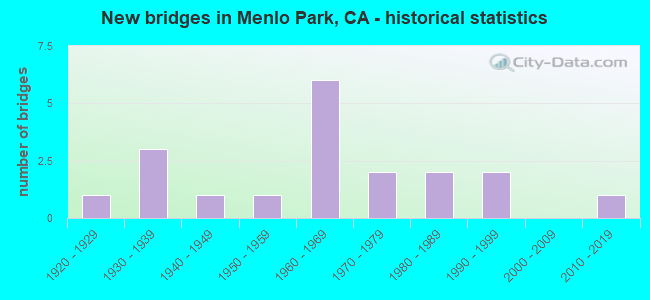
- New bridges - historical statistics
- 11920-1929
- 31930-1939
- 11940-1949
- 11950-1959
- 61960-1969
- 21970-1979
- 21980-1989
- 21990-1999
- 12010-2019

- Reconstructed bridges - Historical Statistics
- 11940-1949
- 11950-1959
- 11960-1969


- Bridge Condition - Deck
- 60.0%Good
- 20.0%Satisfactory
- 20.0%Fair

- Bridge Condition - Superstructure
- 45.5%Good
- 18.2%Satisfactory
- 27.3%Fair
- 9.1%Poor

- Bridge Condition - Substructure
- 72.7%Good
- 18.2%Fair
- 9.1%Poor

- Bridge Condition - Channel
- 11.1%Excellent
- 44.4%Very good
- 22.2%Good
- 22.2%Satisfactory

- Bridge Condition - Culverts
- 33.3%Good
- 66.7%Satisfactory
Find on map >> Show street view
Structure Number: 35 0007, Location: 04-SM-280-R1.56 (Lat: 37.418619, Lng: -122.219650), Route carried "on" structure: County highway D307, Year Built: 1969, Status: Open, Structure Length: 17.32m (56.82ft), Average Daily Traffic: 13,000 (year 2009), Truck Traffic: 1%, Average Future Daily Traffic: 25,651 (year 2038), Design Load: HS 20+Mod, Features Intersected: INTERSTATE 280, Facility Carried by Structure: SAND HILL ROAD (S)
Minimum Vertical Clearance: 30+ m (98+ ft), Kilometerpoint: 0.000, Lanes on structure: 2, Lanes under structure: 12, Base Highway Network: Yes, Owner: State Highway Agency, Approaching Roadway Width: 9.1m (29.9ft), Skew: 5 degrees, Material/Design: Prestressed concrete continuous, Design/Construction: Box Beam or Girders - Multiple, Number Of Spans In Main Unit: 4, Length of Maximum Span: 47.9m (157.2ft), Curb-To-Curb Width: 9.8m (32.2ft), Out-to-Out Width: 10.9m (35.8ft)
Condition: Deck: Good, Superstructure: Fair, Substructure: Good, Operating Rating: 99.8 metric tons, Method Used To Determine Operating Rating: Load Factor (LF), Inventory Rating: 32.4 metric tons, Method Used To Determine Inventory Rating: Load Factor (LF), Structural Evaluation: Somewhat better than minimum adequacy, Deck Geometry: Meets minimum limits, Underclear: Equal to present minimum criteria, Approach Roadway Alignment: Equal to present desirable criteria, Designated Inspection Frequency: Every 24 months, Inspection Date: October 2021, Deck Structure Type: Concrete Cast-file-Place
Find on map >> Show street view
Structure Number: 35 0008, Location: 04-SM-280-R1.61 (Lat: 37.418822, Lng: -122.220614), Route carried "on" structure: County highway D307, Year Built: 1969, Status: Open, Structure Length: 16.43m (53.90ft), Average Daily Traffic: 13,000 (year 1998), Truck Traffic: 1%, Average Future Daily Traffic: 25,651 (year 2038), Design Load: HS 20+Mod, Features Intersected: INTERSTATE 280, Facility Carried by Structure: SAND HILL ROAD (N)
Minimum Vertical Clearance: 30+ m (98+ ft), Kilometerpoint: 0.000, Lanes on structure: 2, Lanes under structure: 12, Base Highway Network: Yes, Owner: State Highway Agency, Approaching Roadway Width: 8.5m (27.9ft), Skew: 5 degrees, Material/Design: Prestressed concrete continuous, Design/Construction: Box Beam or Girders - Multiple, Number Of Spans In Main Unit: 4, Length of Maximum Span: 47.0m (154.2ft), Curb or Sidewalk Widths: Left: 1.5m (4.9ft), Right: 0.0m, Curb-To-Curb Width: 9.1m (29.9ft), Out-to-Out Width: 11.8m (38.7ft)
Condition: Deck: Good, Superstructure: Fair, Substructure: Fair, Operating Rating: 99.8 metric tons, Method Used To Determine Operating Rating: Load Factor (LF), Inventory Rating: 32.4 metric tons, Method Used To Determine Inventory Rating: Load Factor (LF), Structural Evaluation: Somewhat better than minimum adequacy, Deck Geometry: Meets minimum limits, Underclear: Equal to present minimum criteria, Approach Roadway Alignment: Equal to present desirable criteria, Designated Inspection Frequency: Every 24 months, Inspection Date: October 2021, Deck Structure Type: Concrete Cast-file-Place
Find on map >> Show street view
Structure Number: 35 001, Location: 04-SM-101-13.44-SM (Lat: 37.570594, Lng: -122.313386), Route carried "on" structure: US 101, Year Built: 1928, Year Reconstructed: 1952, Status: Open, Structure Length: 2.23m (7.32ft), Average Daily Traffic: 236,000 (year 2009), Truck Traffic: 4%, Average Future Daily Traffic: 309,621 (year 2039), Design Load: HS 15, Features Intersected: SAN MATEO CREEK
Minimum Vertical Clearance: 30+ m (98+ ft), Kilometerpoint: 13.440, Lanes on structure: 12, Base Highway Network: Yes (Inventory Route: 1, Subroute: 1), Owner: State Highway Agency, Approaching Roadway Width: 77.3m (253.6ft), Skew: 30 degrees, Material/Design: Concrete, Design/Construction: Tee Beam, Number Of Spans In Main Unit: 1, Number Of Approach Spans: 1, Length of Maximum Span: 9.1m (29.9ft), Curb or Sidewalk Widths: Left: 0.0m, Right: 1.0m (3.3ft), Curb-To-Curb Width: 74.7m (245.1ft), Out-to-Out Width: 77.3m (253.6ft)
Condition: Deck: Good, Superstructure: Good, Substructure: Good, Channel: Very good, Operating Rating: 40.2 metric tons, Method Used To Determine Operating Rating: Load Factor (LF), Inventory Rating: 24.0 metric tons, Method Used To Determine Inventory Rating: Load Factor (LF), Structural Evaluation: Somewhat better than minimum adequacy, Deck Geometry: Superior to present desirable criteria, Waterway Adequacy: High priority of corrective action, Approach Roadway Alignment: Equal to present desirable criteria, Designated Inspection Frequency: Every 24 months, Inspection Date: August 2021, Deck Structure Type: Concrete Cast-file-Place, Wearing Surface/Protective System: Wearing Surface: Bituminous
Find on map >> Show street view
Structure Number: 35 003, Location: 04-SM-001-17.90 (Lat: 37.320650, Lng: -122.402019), Route carried "on" structure: State highway 1, Year Built: 1941, Status: Open, Structure Length: 8.08m (26.51ft), Average Daily Traffic: 6,100 (year 2009), Truck Traffic: 5%, Average Future Daily Traffic: 9,007 (year 2037), Design Load: H 20, Features Intersected: SAN GREGORIO CREEK
Minimum Vertical Clearance: 30+ m (98+ ft), Kilometerpoint: 17.900, Lanes on structure: 2, Base Highway Network: Yes (, Subroute: 1), Owner: State Highway Agency, Approaching Roadway Width: 7.9m (25.9ft), Material/Design: Concrete continuous, Design/Construction: Tee Beam, Number Of Spans In Main Unit: 5, Length of Maximum Span: 18.0m (59.1ft), Curb or Sidewalk Widths: Left: 0.6m (2.0ft), Right: 0.6m (2.0ft), Curb-To-Curb Width: 7.9m (25.9ft), Out-to-Out Width: 9.7m (31.8ft)
Condition: Deck: Fair, Superstructure: Poor, Substructure: Poor, Channel: Very good, Operating Rating: 53.8 metric tons, Method Used To Determine Operating Rating: Load Factor (LF), Inventory Rating: 32.4 metric tons, Method Used To Determine Inventory Rating: Load Factor (LF), Structural Evaluation: Meets minimum limits, Deck Geometry: High priority of corrective action, Waterway Adequacy: Superior to present desirable criteria, Approach Roadway Alignment: Equal to present minimum criteria, Length Of Structure Improvement: 8.08m (26.51ft), Designated Inspection Frequency: Every 24 months, Inspection Date: October 2020, Bridge Improvement Cost: $1,803,000, Roadway Improvement Cost: $360,000, Total Project Cost: $3,029,000 ( Estimate for 2017), Deck Structure Type: Concrete Cast-file-Place
Find on map >> Show street view
Structure Number: 35 0038, Location: 04-SM-084-R29.25-MLP (Lat: 37.499150, Lng: -122.128383), Route carried "on" structure: State highway 84, Year Built: 1981, Status: Open, Structure Length: 262.13m (860.01ft), Average Daily Traffic: 61,000 (year 2014), Truck Traffic: 4%, Average Future Daily Traffic: 130,000 (year 2039), Design Load: HS 20, Features Intersected: SAN FRANCISCO BAY-SOUTH
Minimum Vertical Clearance: 30+ m (98+ ft), Kilometerpoint: 29.250, Lanes on structure: 6, Base Highway Network: Yes (, Subroute: 1), Toll: Toll bridge, Owner: State Highway Agency, Approaching Roadway Width: 21.9m (71.9ft), Skew: 30 degrees, Navigation Control: Yes ( Vertical Clearance: 25.9m (85.0ft), Horizontal Clearance: 61.0m (200.1ft)), Material/Design: Steel continuous, Design/Construction: Box Beam or Girders - Multiple, Number Of Spans In Main Unit: 15, Number Of Approach Spans: 70, Length of Maximum Span: 103.6m (339.9ft), Curb or Sidewalk Widths: Left: 0.0m, Right: 2.4m (7.9ft), Curb-To-Curb Width: 21.3m (69.9ft), Out-to-Out Width: 25.9m (85.0ft)
Condition: Deck: Good, Superstructure: Satisfactory, Substructure: Good, Channel: Excellent, Operating Rating: 38.2 metric tons, Method Used To Determine Operating Rating: Load and Resistance Factor Rating (LRFR) rating reported by rating factor(RF) method using HL-93 loadings, Inventory Rating: 28.2 metric tons, Method Used To Determine Inventory Rating: Load and Resistance Factor Rating (LRFR) rating reported by rating factor(RF) method using HL-93 loadings, Structural Evaluation: Equal to present minimum criteria, Deck Geometry: High priority of replacement, Waterway Adequacy: Equal to present desirable criteria, Approach Roadway Alignment: Equal to present desirable criteria, Designated Inspection Frequency: Every 24 months, Critical Feature Inspection Frequency: Every 24 months, Underwater Inspection Frequency: Every 60 months, Inspection Date: June 2021, Critical Feature Inspection Date: January 2021, Underwater Inspection Date: September 2018, Deck Structure Type: Concrete Cast-file-Place, Wearing Surface/Protective System: Wearing Surface: Monolithic Concrete
Find on map >> Show street view
Structure Number: 35 0062G, Location: 04-SM-280-R20.90-SBR (Lat: 37.626083, Lng: -122.428958), Route carried "on" structure: Ramp Interstate 280, Year Built: 1971, Status: Open, Structure Length: 3.29m (10.79ft), Average Daily Traffic: 11,500 (year 2005), Truck Traffic: 2%, Average Future Daily Traffic: 14,429 (year 2038), Design Load: HS 20+Mod, Features Intersected: SAN BRUNO AV-N280 ON-RMP
Minimum Vertical Clearance: 30+ m (98+ ft), Kilometerpoint: 20.900, Lanes on structure: 2, Lanes under structure: 1, Base Highway Network: Yes, Owner: State Highway Agency, Approaching Roadway Width: 11.9m (39.0ft), Skew: 4 degrees, Material/Design: Prestressed concrete, Design/Construction: Box Beam or Girders - Multiple, Number Of Spans In Main Unit: 1, Length of Maximum Span: 32.3m (106.0ft), Curb-To-Curb Width: 11.9m (39.0ft), Out-to-Out Width: 13.0m (42.7ft)
Condition: Deck: Satisfactory, Superstructure: Satisfactory, Substructure: Good, Operating Rating: 83.3 metric tons, Method Used To Determine Operating Rating: Load Factor (LF), Inventory Rating: 32.4 metric tons, Method Used To Determine Inventory Rating: Load Factor (LF), Structural Evaluation: Equal to present minimum criteria, Deck Geometry: Superior to present desirable criteria, Underclear: Meets minimum limits, Approach Roadway Alignment: Equal to present minimum criteria, Designated Inspection Frequency: Every 24 months, Inspection Date: July 2021, Deck Structure Type: Concrete Cast-file-Place
Find on map >> Show street view
Structure Number: 35 0064, Location: 04-SM-101-3.70-MLP (Lat: 37.484128, Lng: -122.182444), Route carried "on" structure: US 101, Year Built: 1930, Year Reconstructed: 1958, Status: Open, Structure Length: 0.70m (2.30ft), Average Daily Traffic: 199,000 (year 2009), Truck Traffic: 4%, Average Future Daily Traffic: 251,547 (year 2039), Features Intersected: MARSH CREEK
Minimum Vertical Clearance: 30+ m (98+ ft), Kilometerpoint: 3.700, Lanes on structure: 10, Base Highway Network: Yes (Inventory Route: 1, Subroute: 1), Owner: State Highway Agency, Approaching Roadway Width: 63.1m (207.0ft), Skew: 30 degrees, Material/Design: Concrete continuous, Design/Construction: Culvert, Number Of Spans In Main Unit: 2, Length of Maximum Span: 3.0m (9.8ft), Curb-To-Curb Width: 82.4m (270.3ft), Out-to-Out Width: 84.0m (275.6ft)
Condition: Channel: Satisfactory, Culverts: Satisfactory, Operating Rating: 40.5 metric tons, Method Used To Determine Operating Rating: Field evaluation and documented engineering judgment, Inventory Rating: 24.3 metric tons, Method Used To Determine Inventory Rating: Field evaluation and documented engineering judgment, Structural Evaluation: Equal to present minimum criteria, Deck Geometry: Superior to present desirable criteria, Waterway Adequacy: Equal to present desirable criteria, Approach Roadway Alignment: Equal to present desirable criteria, Designated Inspection Frequency: Every 24 months, Inspection Date: August 2021, Deck Structure Type: Concrete Cast-file-Place, Wearing Surface/Protective System: Wearing Surface: Bituminous
Find on map >> Show street view
Structure Number: 35 0066, Location: 04-SM-084-R25.81-MLP (Lat: 37.483331, Lng: -122.180667), Route carried "on" structure: State highway 84, Year Built: 1998, Status: Open, Structure Length: 6.77m (22.21ft), Average Daily Traffic: 27,500 (year 2009), Truck Traffic: 3%, Average Future Daily Traffic: 65,508 (year 2037), Design Load: HS 20+Mod, Features Intersected: US HIGHWAY 101
Minimum Vertical Clearance: 30+ m (98+ ft), Kilometerpoint: 25.810, Lanes on structure: 5, Lanes under structure: 10, Base Highway Network: Yes (, Subroute: 1), Owner: State Highway Agency, Approaching Roadway Width: 23.2m (76.1ft), Skew: 21 degrees, Material/Design: Prestressed concrete continuous, Design/Construction: Box Beam or Girders - Multiple, Number Of Spans In Main Unit: 2, Length of Maximum Span: 35.1m (115.2ft), Curb or Sidewalk Widths: Left: 1.5m (4.9ft), Right: 1.5m (4.9ft), Curb-To-Curb Width: 23.2m (76.1ft), Out-to-Out Width: 26.8m (87.9ft)
Condition: Deck: Good, Superstructure: Good, Substructure: Good, Operating Rating: 54.1 metric tons, Method Used To Determine Operating Rating: Assigned rating based on Load Factor Design (LFD) reported in metric tons, Inventory Rating: 32.4 metric tons, Method Used To Determine Inventory Rating: Assigned rating based on Load Factor Design (LFD) reported in metric tons, Structural Evaluation: Better than present minimum criteria, Deck Geometry: Somewhat better than minimum adequacy, Underclear: High priority of corrective action, Approach Roadway Alignment: Equal to present desirable criteria, Designated Inspection Frequency: Every 24 months, Inspection Date: May 2020, Deck Structure Type: Concrete Cast-file-Place
Find on map >> Show street view
Structure Number: 35 0194, Location: 04-SM-280-R1.02 (Lat: 37.415506, Lng: -122.210097), Route carried "on" structure: Interstate 280, Year Built: 1965, Year Reconstructed: 1969, Status: Open, Structure Length: 8.28m (27.17ft), Average Daily Traffic: 101,000 (year 2009), Truck Traffic: 3%, Average Future Daily Traffic: 146,745 (year 2038), Design Load: HS 20, Features Intersected: STANFORD LINEAR ACCEL
Minimum Vertical Clearance: 30+ m (98+ ft), Kilometerpoint: 1.020, Lanes on structure: 8, Base Highway Network: Yes (Inventory Route: 2, Subroute: 1), Owner: State Highway Agency, Approaching Roadway Width: 41.5m (136.2ft), Skew: 33 degrees, Material/Design: Steel continuous, Design/Construction: Stringer/Multi-beam, Number Of Spans In Main Unit: 3, Length of Maximum Span: 34.3m (112.5ft), Curb-To-Curb Width: 45.9m (150.6ft), Out-to-Out Width: 47.2m (154.9ft)
Condition: Deck: Fair, Superstructure: Good, Substructure: Fair, Operating Rating: 42.8 metric tons, Method Used To Determine Operating Rating: Load and Resistance Factor Rating (LRFR) rating reported by rating factor(RF) method using HL-93 loadings, Inventory Rating: 33.0 metric tons, Method Used To Determine Inventory Rating: Load and Resistance Factor Rating (LRFR) rating reported by rating factor(RF) method using HL-93 loadings, Structural Evaluation: Somewhat better than minimum adequacy, Deck Geometry: Superior to present desirable criteria, Approach Roadway Alignment: Equal to present desirable criteria, Length Of Structure Improvement: 8.29m (27.20ft), Designated Inspection Frequency: Every 24 months, Other Special Inspection Frequency: Every 48 months, Inspection Date: October 2021, Other Special Inspection Date: August 2019, Deck Structure Type: Concrete Cast-file-Place
Find on map >> Show street view
Structure Number: 35 0357, Location: 04-SM-000-0.00-MLP (Lat: 37.486811, Lng: -122.181033), Route carried "on" structure: City street , Year Built: 1954, Status: Open, Structure Length: 0.67m (2.20ft), Average Daily Traffic: 6,400 (year 2009), Truck Traffic: 10%, Average Future Daily Traffic: 6,499 (year 2037), Features Intersected: MARSH SLOUGH, Facility Carried by Structure: HAVEN AVE
Minimum Vertical Clearance: 30+ m (98+ ft), Kilometerpoint: 0.000, Lanes on structure: 2, Owner: State Highway Agency, Approaching Roadway Width: 12.2m (40.0ft), Material/Design: Concrete continuous, Design/Construction: Culvert, Number Of Spans In Main Unit: 2, Length of Maximum Span: 3.0m (9.8ft), Curb or Sidewalk Widths: Left: 0.3m (1.0ft), Right: 0.3m (1.0ft), Curb-To-Curb Width: 12.2m (40.0ft), Out-to-Out Width: 12.8m (42.0ft)
Condition: Channel: Satisfactory, Culverts: Satisfactory, Operating Rating: 40.5 metric tons, Method Used To Determine Operating Rating: Field evaluation and documented engineering judgment, Inventory Rating: 24.3 metric tons, Method Used To Determine Inventory Rating: Field evaluation and documented engineering judgment, Structural Evaluation: Equal to present minimum criteria, Deck Geometry: Somewhat better than minimum adequacy, Waterway Adequacy: Better than present minimum criteria, Approach Roadway Alignment: High priority of corrective action, Designated Inspection Frequency: Every 24 months, Inspection Date: May 2020, Deck Structure Type: Concrete Cast-file-Place, Wearing Surface/Protective System: Wearing Surface: Bituminous
Find on map >> Show street view
Structure Number: 35C0101, Location: 0.2 MI E OF S AIRPORT BLV (Lat: 37.646125, Lng: -122.401375), Route carried "on" structure: City street , Year Built: 1975, Status: Open, Structure Length: 4.72m (15.49ft), Average Daily Traffic: 12,150 (year 2010), Truck Traffic: 12%, Average Future Daily Traffic: 9,620 (year 2039), Design Load: HS 20, Features Intersected: COLMA CREEK, Facility Carried by Structure: UTAH AVE
Minimum Vertical Clearance: 30+ m (98+ ft), Kilometerpoint: 0.000, Lanes on structure: 2, Owner: City or Municipal Highway Agency, Approaching Roadway Width: 19.5m (64.0ft), Material/Design: Concrete continuous, Design/Construction: Slab, Number Of Spans In Main Unit: 4, Length of Maximum Span: 13.1m (43.0ft), Curb or Sidewalk Widths: Left: 1.5m (4.9ft), Right: 1.5m (4.9ft), Curb-To-Curb Width: 19.5m (64.0ft), Out-to-Out Width: 23.2m (76.1ft)
Condition: Deck: Good, Superstructure: Good, Substructure: Good, Channel: Very good, Operating Rating: 78.1 metric tons, Method Used To Determine Operating Rating: Load Factor (LF), Inventory Rating: 47.0 metric tons, Method Used To Determine Inventory Rating: Load Factor (LF), Structural Evaluation: Better than present minimum criteria, Deck Geometry: Superior to present desirable criteria, Waterway Adequacy: Equal to present desirable criteria, Approach Roadway Alignment: Somewhat better than minimum adequacy, Designated Inspection Frequency: Every 48 months, Inspection Date: April 2019, Deck Structure Type: Concrete Cast-file-Place
Find on map >> Show street view
Structure Number: 35C0108, Location: MARSH RD AT ROLISON (Lat: 37.482986, Lng: -122.183214), Route carried "on" structure: City street , Year Built: 1960, Status: Open, Structure Length: 0.67m (2.20ft), Average Daily Traffic: 5,300 (year 2018), Truck Traffic: 1%, Average Future Daily Traffic: 6,630 (year 2042), Features Intersected: MARSH SLOUGH, Facility Carried by Structure: MARSH RD
Minimum Vertical Clearance: 30+ m (98+ ft), Kilometerpoint: 0.000, Lanes on structure: 4, Owner: City or Municipal Highway Agency, Approaching Roadway Width: 28.3m (92.8ft), Skew: 24 degrees, Material/Design: Concrete continuous, Design/Construction: Culvert, Number Of Spans In Main Unit: 2, Length of Maximum Span: 3.4m (11.2ft), Curb or Sidewalk Widths: Left: 0.0m, Right: 3.6m (11.8ft), Curb-To-Curb Width: 28.3m (92.8ft), Out-to-Out Width: 28.3m (92.8ft)
Condition: Channel: Good, Culverts: Good, Operating Rating: 40.5 metric tons, Method Used To Determine Operating Rating: Field evaluation and documented engineering judgment, Inventory Rating: 24.3 metric tons, Method Used To Determine Inventory Rating: Field evaluation and documented engineering judgment, Structural Evaluation: Equal to present minimum criteria, Deck Geometry: Superior to present desirable criteria, Waterway Adequacy: Better than present minimum criteria, Approach Roadway Alignment: Equal to present minimum criteria, Designated Inspection Frequency: Every 24 months, Inspection Date: April 2020, Deck Structure Type: Concrete Cast-file-Place, Wearing Surface/Protective System: Wearing Surface: Bituminous
Find on map >> Show street view
Structure Number: 35C0109, Location: 0.1 MI E WILLOW RD (Lat: 37.453942, Lng: -122.162614), Route carried "on" structure: City street , Year Built: 1936, Status: Open, Structure Length: 0.91m (2.99ft), Average Daily Traffic: 18,700 (year 2016), Truck Traffic: 5%, Average Future Daily Traffic: 28,858 (year 2040), Features Intersected: SAN FRANCISQUITO CREEK, Facility Carried by Structure: MIDDLEFIELD RD
Minimum Vertical Clearance: 30+ m (98+ ft), Kilometerpoint: 0.000, Lanes on structure: 3, Owner: City or Municipal Highway Agency, Approaching Roadway Width: 11.0m (36.1ft), Skew: 1 degrees, Material/Design: Concrete, Design/Construction: Arch - Deck, Number Of Spans In Main Unit: 1, Length of Maximum Span: 8.5m (27.9ft), Curb-To-Curb Width: 11.0m (36.1ft), Out-to-Out Width: 11.0m (36.1ft)
Condition: Superstructure: Fair, Substructure: Good, Channel: Good, Operating Rating: 27.2 metric tons, Method Used To Determine Operating Rating: Field evaluation and documented engineering judgment, Inventory Rating: 16.2 metric tons, Method Used To Determine Inventory Rating: Field evaluation and documented engineering judgment, Structural Evaluation: Meets minimum limits, Deck Geometry: High priority of replacement, Waterway Adequacy: Better than present minimum criteria, Approach Roadway Alignment: Equal to present minimum criteria, Designated Inspection Frequency: Every 24 months, Inspection Date: April 2020
Find on map >> Show street view
Structure Number: 37C0346, Location: EAST OF ALPINE ROAD (Lat: 37.424344, Lng: -122.191236), Route carried "on" structure: County highway , Year Built: 1989, Status: Open, Structure Length: 6.75m (22.15ft), Average Daily Traffic: 20,000 (year 2015), Truck Traffic: 3%, Average Future Daily Traffic: 30,605 (year 2040), Design Load: HS 20+Mod, Features Intersected: SAN FRANCISQUITO CREEK, Facility Carried by Structure: JUNIPERO SERRA BLD
Minimum Vertical Clearance: 30+ m (98+ ft), Kilometerpoint: 0.000, Lanes on structure: 4, Base Highway Network: Yes, Owner: County Highway Agency, Approaching Roadway Width: 12.2m (40.0ft), Skew: 3 degrees, Material/Design: Prestressed concrete continuous, Design/Construction: Stringer/Multi-beam, Number Of Spans In Main Unit: 3, Length of Maximum Span: 24.5m (80.4ft), Curb-To-Curb Width: 17.8m (58.4ft), Out-to-Out Width: 18.9m (62.0ft)
Condition: Deck: Satisfactory, Superstructure: Good, Substructure: Good, Channel: Very good, Operating Rating: 54.1 metric tons, Method Used To Determine Operating Rating: Assigned rating based on Load Factor Design (LFD) reported in metric tons, Inventory Rating: 32.4 metric tons, Method Used To Determine Inventory Rating: Assigned rating based on Load Factor Design (LFD) reported in metric tons, Structural Evaluation: Better than present minimum criteria, Deck Geometry: Somewhat better than minimum adequacy, Waterway Adequacy: Superior to present desirable criteria, Approach Roadway Alignment: Equal to present minimum criteria, Designated Inspection Frequency: Every 24 months, Inspection Date: September 2021, Deck Structure Type: Concrete Cast-file-Place
Find on map >> Show street view
Structure Number: 35 0007, Location: 04-SM-280-R1.56 (Lat: 37.418619, Lng: -122.219650), Route carried "under" structure: Interstate 280, Year Built: 1969, Structure Length: 0. m, Average Daily Traffic: 101,000 (year 2009), Truck Traffic: 3%, Features Intersected: INTERSTATE 280, Facility Carried by Structure: SAND HILL ROAD (S)
Minimum Vertical Clearance: 5.06m (16.60ft), Kilometerpoint: 1.560, Lanes on structure: 2, Lanes under structure: 12, Material/Design: Prestressed concrete continuous, Design/Construction: Box Beam or Girders - Multiple, Length of Maximum Span: 47.9m (157.2ft)
Find on map >> Show street view
Structure Number: 35 0008, Location: 04-SM-280-R1.61 (Lat: 37.418822, Lng: -122.220614), Route carried "under" structure: Interstate 280, Year Built: 1969, Structure Length: 0. m, Average Daily Traffic: 101,000 (year 2009), Truck Traffic: 3%, Features Intersected: INTERSTATE 280, Facility Carried by Structure: SAND HILL ROAD (N)
Minimum Vertical Clearance: 5.18m (16.99ft), Kilometerpoint: 1.610, Lanes on structure: 2, Lanes under structure: 12, Material/Design: Prestressed concrete continuous, Design/Construction: Box Beam or Girders - Multiple, Length of Maximum Span: 47.0m (154.2ft)
Find on map >> Show street view
Structure Number: 35 0012, Location: 04-SM-101-3.05-MLP (Lat: 37.478953, Lng: -122.172894), Route carried "under" structure: US 101, Year Built: 1931, Structure Length: 0. m, Average Daily Traffic: 199,000 (year 2009), Truck Traffic: 4%, Features Intersected: U.S. HIGHWAY 101, Facility Carried by Structure: CALTRAIN & UP RR
Minimum Vertical Clearance: 4.60m (15.09ft), Kilometerpoint: 3.050, Lanes under structure: 10, Material/Design: Steel, Design/Construction: Girder and Floorbeam System, Length of Maximum Span: 33.8m (110.9ft)
Find on map >> Show street view
Structure Number: 35 0066, Location: 04-SM-084-R25.81-MLP (Lat: 37.483331, Lng: -122.180667), Route carried "under" structure: US 101, Year Built: 1998, Structure Length: 0. m, Average Daily Traffic: 199,000 (year 2009), Truck Traffic: 4%, Features Intersected: US HIGHWAY 101, Facility Carried by Structure: SR 84 (MARSH RD)
Minimum Vertical Clearance: 5.66m (18.57ft), Kilometerpoint: 3.590, Lanes on structure: 5, Lanes under structure: 10, Material/Design: Prestressed concrete continuous, Design/Construction: Box Beam or Girders - Multiple, Length of Maximum Span: 35.1m (115.2ft)
Find on map >> Show street view
Structure Number: 35 0347, Location: 04-SM-101-2.57-MLP (Lat: 37.474800, Lng: -122.165797), Route carried "under" structure: US 101, Year Built: 2012, Structure Length: 0. m, Average Daily Traffic: 199,000 (year 2009), Truck Traffic: 4%, Features Intersected: U.S. HIGHWAY 101, Facility Carried by Structure: PEDESTRIAN WALKWAY
Minimum Vertical Clearance: 5.64m (18.50ft), Kilometerpoint: 2.570, Lanes under structure: 10, Material/Design: Prestressed concrete continuous, Design/Construction: Box Beam or Girders - Single/Spread, Length of Maximum Span: 25.2m (82.7ft)