Bridge Statistics for Mecca, California (CA)
Condition, Traffic, Stress, Structural Evaluation, Project Costs
- National Bridge Inventory (NBI) Statistics
- 16Number of bridges
- 246ft / 74.6mTotal length
- 604,498Total average daily traffic
- 108,449Total average daily truck traffic
- National Bridge Inventory (NBI) Registered Bridges for Mecca
- No street view available for this location
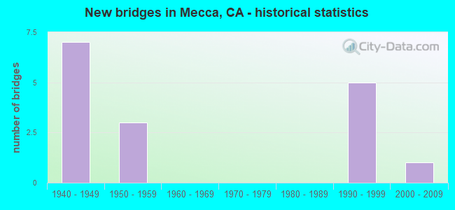
- New bridges - historical statistics
- 71940-1949
- 31950-1959
- 51990-1999
- 12000-2009

- Reconstructed bridges - Historical Statistics
- 11960-1969
- 01970-1979
- 11980-1989
- 31990-1999
- 02000-2009
- 12010-2019


- Bridge Condition - Deck
- 25.0%Good
- 75.0%Fair

- Bridge Condition - Superstructure
- 25.0%Good
- 75.0%Fair

- Bridge Condition - Substructure
- 75.0%Good
- 25.0%Fair

- Bridge Condition - Channel
- 18.2%Excellent
- 36.4%Very good
- 36.4%Good
- 9.1%Satisfactory

- Bridge Condition - Culverts
- 50.0%Good
- 50.0%Satisfactory
Find on map >> Show street view
Structure Number: 56 0266, Location: 08-RIV-111-15.78 (Lat: 33.546561, Lng: -116.044347), Route carried "on" structure: State highway 111, Year Built: 1949, Year Reconstructed: 1992, Status: Open, Structure Length: 0.82m (2.69ft), Average Daily Traffic: 2,700 (year 2012), Truck Traffic: 11%, Average Future Daily Traffic: 4,263 (year 2038), Features Intersected: NOE WASH
Minimum Vertical Clearance: 30+ m (98+ ft), Kilometerpoint: 15.780, Lanes on structure: 2, Base Highway Network: Yes (Inventory Route: 1, Subroute: 1), Owner: State Highway Agency, Approaching Roadway Width: 9.8m (32.2ft), Material/Design: Concrete, Design/Construction: Culvert, Number Of Spans In Main Unit: 3, Length of Maximum Span: 2.7m (8.9ft), Curb-To-Curb Width: 9.8m (32.2ft), Out-to-Out Width: 14.6m (47.9ft)
Condition: Channel: Good, Culverts: Satisfactory, Operating Rating: 54.1 metric tons, Method Used To Determine Operating Rating: Field evaluation and documented engineering judgment, Inventory Rating: 32.4 metric tons, Method Used To Determine Inventory Rating: Field evaluation and documented engineering judgment, Structural Evaluation: Equal to present minimum criteria, Deck Geometry: Meets minimum limits, Waterway Adequacy: Equal to present desirable criteria, Approach Roadway Alignment: Equal to present desirable criteria, Designated Inspection Frequency: Every 48 months, Inspection Date: May 2021
Find on map >> Show street view
Structure Number: 56 0267, Location: 08-RIV-111-17.07 (Lat: 33.555219, Lng: -116.064031), Route carried "on" structure: State highway 111, Year Built: 1948, Status: Open, Structure Length: 0.64m (2.10ft), Average Daily Traffic: 2,700 (year 2012), Truck Traffic: 11%, Average Future Daily Traffic: 4,263 (year 2038), Features Intersected: FLATBUSH WASH
Minimum Vertical Clearance: 30+ m (98+ ft), Kilometerpoint: 17.070, Lanes on structure: 2, Base Highway Network: Yes (Inventory Route: 1, Subroute: 1), Owner: State Highway Agency, Approaching Roadway Width: 9.8m (32.2ft), Skew: 3 degrees, Material/Design: Concrete, Design/Construction: Culvert, Number Of Spans In Main Unit: 2, Length of Maximum Span: 2.4m (7.9ft), Curb-To-Curb Width: 9.8m (32.2ft), Out-to-Out Width: 15.9m (52.2ft)
Condition: Channel: Good, Culverts: Satisfactory, Operating Rating: 54.1 metric tons, Method Used To Determine Operating Rating: Field evaluation and documented engineering judgment, Inventory Rating: 32.4 metric tons, Method Used To Determine Inventory Rating: Field evaluation and documented engineering judgment, Structural Evaluation: Equal to present minimum criteria, Deck Geometry: Meets minimum limits, Waterway Adequacy: Better than present minimum criteria, Approach Roadway Alignment: Equal to present desirable criteria, Designated Inspection Frequency: Every 48 months, Inspection Date: May 2021
Find on map >> Show street view
Structure Number: 56 0268, Location: 08-RIV-111-17.99 (Lat: 33.565206, Lng: -116.074431), Route carried "on" structure: State highway 111, Year Built: 1949, Status: Open, Structure Length: 0.73m (2.40ft), Average Daily Traffic: 2,700 (year 2012), Truck Traffic: 11%, Average Future Daily Traffic: 4,306 (year 2038), Features Intersected: MECCA WASH
Minimum Vertical Clearance: 30+ m (98+ ft), Kilometerpoint: 17.990, Lanes on structure: 2, Base Highway Network: Yes (Inventory Route: 1, Subroute: 1), Owner: State Highway Agency, Approaching Roadway Width: 9.8m (32.2ft), Skew: 4 degrees, Material/Design: Concrete, Design/Construction: Culvert, Number Of Spans In Main Unit: 2, Length of Maximum Span: 2.4m (7.9ft), Curb-To-Curb Width: 9.8m (32.2ft), Out-to-Out Width: 14.3m (46.9ft)
Condition: Channel: Good, Culverts: Satisfactory, Operating Rating: 54.1 metric tons, Method Used To Determine Operating Rating: Field evaluation and documented engineering judgment, Inventory Rating: 32.4 metric tons, Method Used To Determine Inventory Rating: Field evaluation and documented engineering judgment, Structural Evaluation: Equal to present minimum criteria, Deck Geometry: Meets minimum limits, Waterway Adequacy: Equal to present desirable criteria, Approach Roadway Alignment: Equal to present desirable criteria, Designated Inspection Frequency: Every 48 months, Inspection Date: May 2021
Find on map >> Show street view
Structure Number: 56 0274, Location: 08-RIV-111-14.03 (Lat: 33.536636, Lng: -116.016542), Route carried "on" structure: State highway 111, Year Built: 1951, Year Reconstructed: 1997, Status: Open, Structure Length: 0.79m (2.59ft), Average Daily Traffic: 2,700 (year 2012), Truck Traffic: 11%, Average Future Daily Traffic: 4,263 (year 2038), Design Load: HS 20, Features Intersected: CALEB WASH
Minimum Vertical Clearance: 30+ m (98+ ft), Kilometerpoint: 14.030, Lanes on structure: 2, Base Highway Network: Yes (Inventory Route: 1, Subroute: 1), Owner: State Highway Agency, Approaching Roadway Width: 9.8m (32.2ft), Material/Design: Concrete, Design/Construction: Culvert, Number Of Spans In Main Unit: 3, Length of Maximum Span: 2.7m (8.9ft), Curb-To-Curb Width: 9.8m (32.2ft), Out-to-Out Width: 16.9m (55.4ft)
Condition: Channel: Very good, Culverts: Good, Operating Rating: 54.1 metric tons, Method Used To Determine Operating Rating: Field evaluation and documented engineering judgment, Inventory Rating: 32.4 metric tons, Method Used To Determine Inventory Rating: Field evaluation and documented engineering judgment, Structural Evaluation: Better than present minimum criteria, Deck Geometry: Meets minimum limits, Waterway Adequacy: Equal to present desirable criteria, Approach Roadway Alignment: Equal to present desirable criteria, Designated Inspection Frequency: Every 48 months, Inspection Date: May 2021, Deck Structure Type: Concrete Cast-file-Place, Wearing Surface/Protective System: Wearing Surface: Bituminous
Find on map >> Show street view
Structure Number: 56 0275, Location: 08-RIV-111-13.56 (Lat: 33.535933, Lng: -116.008483), Route carried "on" structure: State highway 111, Year Built: 1951, Year Reconstructed: 1997, Status: Open, Structure Length: 0.79m (2.59ft), Average Daily Traffic: 2,700 (year 2012), Truck Traffic: 11%, Average Future Daily Traffic: 4,263 (year 2038), Design Load: HS 20, Features Intersected: ZIMMERER WASH
Minimum Vertical Clearance: 30+ m (98+ ft), Kilometerpoint: 13.560, Lanes on structure: 2, Base Highway Network: Yes (Inventory Route: 1, Subroute: 1), Owner: State Highway Agency, Approaching Roadway Width: 9.8m (32.2ft), Material/Design: Concrete, Design/Construction: Culvert, Number Of Spans In Main Unit: 3, Length of Maximum Span: 2.4m (7.9ft), Curb-To-Curb Width: 9.8m (32.2ft), Out-to-Out Width: 16.9m (55.4ft)
Condition: Channel: Satisfactory, Culverts: Satisfactory, Operating Rating: 54.1 metric tons, Method Used To Determine Operating Rating: Field evaluation and documented engineering judgment, Inventory Rating: 32.4 metric tons, Method Used To Determine Inventory Rating: Field evaluation and documented engineering judgment, Structural Evaluation: Equal to present minimum criteria, Deck Geometry: Meets minimum limits, Waterway Adequacy: Equal to present desirable criteria, Approach Roadway Alignment: Equal to present desirable criteria, Designated Inspection Frequency: Every 48 months, Inspection Date: May 2021, Deck Structure Type: Concrete Cast-file-Place, Wearing Surface/Protective System: Wearing Surface: Bituminous
Find on map >> Show street view
Structure Number: 56 0294, Location: 08-RIV-111-15.34 (Lat: 33.543675, Lng: -116.037506), Route carried "on" structure: State highway 111, Year Built: 1951, Year Reconstructed: 1997, Status: Open, Structure Length: 0.79m (2.59ft), Average Daily Traffic: 2,700 (year 2012), Truck Traffic: 11%, Average Future Daily Traffic: 4,263 (year 2038), Design Load: HS 20, Features Intersected: VINE DITCH
Minimum Vertical Clearance: 30+ m (98+ ft), Kilometerpoint: 15.340, Lanes on structure: 2, Base Highway Network: Yes (Inventory Route: 1, Subroute: 1), Owner: State Highway Agency, Approaching Roadway Width: 9.8m (32.2ft), Material/Design: Concrete, Design/Construction: Culvert, Number Of Spans In Main Unit: 3, Length of Maximum Span: 2.7m (8.9ft), Curb-To-Curb Width: 9.8m (32.2ft), Out-to-Out Width: 16.9m (55.4ft)
Condition: Channel: Good, Culverts: Good, Operating Rating: 54.1 metric tons, Method Used To Determine Operating Rating: Field evaluation and documented engineering judgment, Inventory Rating: 32.4 metric tons, Method Used To Determine Inventory Rating: Field evaluation and documented engineering judgment, Structural Evaluation: Better than present minimum criteria, Deck Geometry: Meets minimum limits, Waterway Adequacy: Equal to present desirable criteria, Approach Roadway Alignment: Equal to present desirable criteria, Designated Inspection Frequency: Every 48 months, Inspection Date: May 2021, Deck Structure Type: Concrete Cast-file-Place, Wearing Surface/Protective System: Wearing Surface: Bituminous
Find on map >> Show street view
Structure Number: 56 0376, Location: 08-RIV-111-18.38 (Lat: 33.569872, Lng: -116.078461), Route carried "on" structure: State highway 111, Year Built: 1949, Year Reconstructed: 1972, Status: Open, Structure Length: 9.70m (31.82ft), Average Daily Traffic: 4,400 (year 2012), Truck Traffic: 11%, Average Future Daily Traffic: 7,829 (year 2038), Features Intersected: LINCOLN DRAINAGE DITCH
Minimum Vertical Clearance: 30+ m (98+ ft), Kilometerpoint: 18.380, Lanes on structure: 3, Base Highway Network: Yes (Inventory Route: 1, Subroute: 1), Owner: State Highway Agency, Approaching Roadway Width: 15.7m (51.5ft), Skew: 4 degrees, Material/Design: Concrete, Design/Construction: Culvert, Number Of Spans In Main Unit: 2, Length of Maximum Span: 3.7m (12.1ft), Curb-To-Curb Width: 15.7m (51.5ft), Out-to-Out Width: 16.9m (55.4ft)
Condition: Channel: Very good, Culverts: Satisfactory, Operating Rating: 54.1 metric tons, Method Used To Determine Operating Rating: Field evaluation and documented engineering judgment, Inventory Rating: 32.4 metric tons, Method Used To Determine Inventory Rating: Field evaluation and documented engineering judgment, Structural Evaluation: Equal to present minimum criteria, Deck Geometry: Better than present minimum criteria, Waterway Adequacy: Equal to present desirable criteria, Approach Roadway Alignment: Equal to present desirable criteria, Designated Inspection Frequency: Every 48 months, Inspection Date: May 2021, Deck Structure Type: Concrete Cast-file-Place, Wearing Surface/Protective System: Wearing Surface: Bituminous
Find on map >> Show street view
Structure Number: 56 0758L, Location: 08-RIV-086-R12.45 (Lat: 33.590711, Lng: -116.096258), Route carried "on" structure: State highway 86, Year Built: 1998, Status: Open, Structure Length: 26.80m (87.93ft), Average Daily Traffic: 143,000 (year 2012), Truck Traffic: 20%, Average Future Daily Traffic: 177,936 (year 2038), Design Load: HS 20+Mod, Features Intersected: STATE ROUTE 111 & UP RR
Minimum Vertical Clearance: 30+ m (98+ ft), Kilometerpoint: 12.450, Lanes on structure: 2, Lanes under structure: 3, Base Highway Network: Yes (Inventory Route: 8, Subroute: 1), Owner: State Highway Agency, Approaching Roadway Width: 11.9m (39.0ft), Skew: 9 degrees, Material/Design: Prestressed concrete continuous, Design/Construction: Box Beam or Girders - Single/Spread, Number Of Spans In Main Unit: 6, Number Of Approach Spans: 2, Length of Maximum Span: 42.7m (140.1ft), Curb-To-Curb Width: 11.9m (39.0ft), Out-to-Out Width: 12.9m (42.3ft)
Condition: Deck: Good, Superstructure: Fair, Substructure: Good, Operating Rating: 54.1 metric tons, Method Used To Determine Operating Rating: Assigned rating based on Load Factor Design (LFD) reported in metric tons, Inventory Rating: 32.4 metric tons, Method Used To Determine Inventory Rating: Assigned rating based on Load Factor Design (LFD) reported in metric tons, Structural Evaluation: Somewhat better than minimum adequacy, Deck Geometry: Better than present minimum criteria, Underclear: Meets minimum limits, Approach Roadway Alignment: Equal to present desirable criteria, Designated Inspection Frequency: Every 24 months, Inspection Date: April 2021, Deck Structure Type: Concrete Cast-file-Place
Find on map >> Show street view
Structure Number: 56 0758R, Location: 08-RIV-086-R12.45 (Lat: 33.590447, Lng: -116.095833), Route carried "on" structure: State highway 86, Year Built: 1998, Status: Open, Structure Length: 25.91m (85.01ft), Average Daily Traffic: 143,000 (year 2012), Truck Traffic: 20%, Average Future Daily Traffic: 177,936 (year 2038), Design Load: HS 20+Mod, Features Intersected: STATE ROUTE 111 & UP RR
Minimum Vertical Clearance: 30+ m (98+ ft), Kilometerpoint: 12.450, Lanes on structure: 2, Lanes under structure: 3, Base Highway Network: Yes (Inventory Route: 8, Subroute: 1), Owner: State Highway Agency, Approaching Roadway Width: 11.9m (39.0ft), Skew: 9 degrees, Material/Design: Prestressed concrete continuous, Design/Construction: Box Beam or Girders - Single/Spread, Number Of Spans In Main Unit: 7, Length of Maximum Span: 40.5m (132.9ft), Curb-To-Curb Width: 11.9m (39.0ft), Out-to-Out Width: 12.9m (42.3ft)
Condition: Deck: Fair, Superstructure: Fair, Substructure: Good, Operating Rating: 54.1 metric tons, Method Used To Determine Operating Rating: Assigned rating based on Load Factor Design (LFD) reported in metric tons, Inventory Rating: 32.4 metric tons, Method Used To Determine Inventory Rating: Assigned rating based on Load Factor Design (LFD) reported in metric tons, Structural Evaluation: Somewhat better than minimum adequacy, Deck Geometry: Better than present minimum criteria, Underclear: Meets minimum limits, Approach Roadway Alignment: Equal to present desirable criteria, Designated Inspection Frequency: Every 24 months, Inspection Date: April 2021, Deck Structure Type: Concrete Cast-file-Place
Find on map >> Show street view
Structure Number: 56 0780R, Location: 08-RIV-086-R11.94 (Lat: 33.583828, Lng: -116.095769), Route carried "on" structure: State highway 86, Year Built: 1998, Status: Open, Structure Length: 3.17m (10.40ft), Average Daily Traffic: 143,000 (year 2012), Truck Traffic: 20%, Average Future Daily Traffic: 177,936 (year 2038), Design Load: HS 20+Mod, Features Intersected: CVWD PIPELINE UC
Minimum Vertical Clearance: 30+ m (98+ ft), Kilometerpoint: 11.940, Lanes on structure: 2, Base Highway Network: Yes (Inventory Route: 8, Subroute: 1), Owner: State Highway Agency, Approaching Roadway Width: 11.9m (39.0ft), Skew: 4 degrees, Material/Design: Concrete, Design/Construction: Slab, Number Of Spans In Main Unit: 3, Length of Maximum Span: 10.9m (35.8ft), Curb-To-Curb Width: 11.9m (39.0ft), Out-to-Out Width: 11.9m (39.0ft)
Condition: Deck: Fair, Superstructure: Fair, Substructure: Good, Operating Rating: 54.1 metric tons, Method Used To Determine Operating Rating: Assigned rating based on Load Factor Design (LFD) reported in metric tons, Inventory Rating: 32.4 metric tons, Method Used To Determine Inventory Rating: Assigned rating based on Load Factor Design (LFD) reported in metric tons, Structural Evaluation: Somewhat better than minimum adequacy, Deck Geometry: Better than present minimum criteria, Approach Roadway Alignment: Equal to present desirable criteria, Designated Inspection Frequency: Every 24 months, Inspection Date: April 2021, Deck Structure Type: Concrete Cast-file-Place
Find on map >> Show street view
Structure Number: 56 0812, Location: 08-RIV-086-R11.64 (Lat: 33.580222, Lng: -116.095350), Route carried "on" structure: State highway 86, Year Built: 2000, Status: Open, Structure Length: 0.62m (2.03ft), Average Daily Traffic: 143,000 (year 2012), Truck Traffic: 14%, Average Future Daily Traffic: 177,936 (year 2038), Design Load: HS 20+Mod, Features Intersected: BUCHANAN CHANNEL
Minimum Vertical Clearance: 30+ m (98+ ft), Kilometerpoint: 11.640, Lanes on structure: 4, Base Highway Network: Yes (Inventory Route: 8, Subroute: 1), Owner: State Highway Agency, Approaching Roadway Width: 30.2m (99.1ft), Skew: 9 degrees, Material/Design: Concrete continuous, Design/Construction: Culvert, Number Of Spans In Main Unit: 2, Length of Maximum Span: 3.1m (10.2ft)
Condition: Channel: Very good, Culverts: Good, Operating Rating: 54.1 metric tons, Method Used To Determine Operating Rating: Field evaluation and documented engineering judgment, Inventory Rating: 32.4 metric tons, Method Used To Determine Inventory Rating: Field evaluation and documented engineering judgment, Structural Evaluation: Better than present minimum criteria, Waterway Adequacy: Equal to present desirable criteria, Approach Roadway Alignment: Equal to present desirable criteria, Designated Inspection Frequency: Every 24 months, Inspection Date: April 2021
Find on map >> Show street view
Structure Number: 56C0173, Location: 0.5 MI NE/O GARFIELD ST (Lat: 33.573939, Lng: -116.001831), Route carried "on" structure: County highway , Year Built: 1947, Status: Open, Structure Length: 1.92m (6.30ft), Average Daily Traffic: 721 (year 2012), Truck Traffic: 2%, Average Future Daily Traffic: 612 (year 2040), Design Load: H 15, Features Intersected: COACHELLA CANAL, Facility Carried by Structure: BOX CANYON RD
Minimum Vertical Clearance: 30+ m (98+ ft), Kilometerpoint: 0.000, Lanes on structure: 2, Owner: County Highway Agency, Approaching Roadway Width: 7.3m (24.0ft), Material/Design: Concrete, Design/Construction: Tee Beam, Number Of Spans In Main Unit: 2, Length of Maximum Span: 10.4m (34.1ft), Curb or Sidewalk Widths: Left: 0.3m (1.0ft), Right: 0.3m (1.0ft), Curb-To-Curb Width: 7.3m (24.0ft), Out-to-Out Width: 8.8m (28.9ft)
Condition: Deck: Fair, Superstructure: Good, Substructure: Fair, Channel: Excellent, Operating Rating: 19.8 metric tons, Method Used To Determine Operating Rating: Load and Resistance Factor Rating (LRFR) rating reported by rating factor(RF) method using HL-93 loadings, Inventory Rating: 13.9 metric tons, Method Used To Determine Inventory Rating: Load and Resistance Factor Rating (LRFR) rating reported by rating factor(RF) method using HL-93 loadings, Structural Evaluation: Meets minimum limits, Deck Geometry: Meets minimum limits, Waterway Adequacy: Superior to present desirable criteria, Approach Roadway Alignment: Equal to present minimum criteria, Designated Inspection Frequency: Every 24 months, Inspection Date: October 2020, Deck Structure Type: Concrete Cast-file-Place
Find on map >> Show street view
Structure Number: 56C0174, Location: 0.01 MI. E/O RTE 111 HWY (Lat: 33.570989, Lng: -116.079364), Route carried "on" structure: County highway , Year Built: 1948, Year Reconstructed: 2018, Status: Open, Structure Length: 0.79m (2.59ft), Average Daily Traffic: 7,576 (year 2013), Truck Traffic: 1%, Average Future Daily Traffic: 8,161 (year 2040), Design Load: H 20, Features Intersected: LINCOLN DRAIN DITCH, Facility Carried by Structure: 66TH AVENUE
Minimum Vertical Clearance: 30+ m (98+ ft), Kilometerpoint: 0.000, Lanes on structure: 3, Owner: County Highway Agency, Approaching Roadway Width: 9.1m (29.9ft), Material/Design: Concrete, Design/Construction: Culvert, Number Of Spans In Main Unit: 2, Length of Maximum Span: 3.7m (12.1ft), Curb-To-Curb Width: 15.5m (50.9ft), Out-to-Out Width: 21.0m (68.9ft)
Condition: Channel: Very good, Culverts: Good, Operating Rating: 54.1 metric tons, Method Used To Determine Operating Rating: Field evaluation and documented engineering judgment, Inventory Rating: 32.4 metric tons, Method Used To Determine Inventory Rating: Field evaluation and documented engineering judgment, Structural Evaluation: Better than present minimum criteria, Deck Geometry: Equal to present minimum criteria, Waterway Adequacy: Equal to present desirable criteria, Approach Roadway Alignment: Equal to present minimum criteria, Designated Inspection Frequency: Every 48 months, Inspection Date: October 2020
Find on map >> Show street view
Structure Number: 56C0592, Location: 0.1 MI SW/O 64TH AVE (Lat: 33.589097, Lng: -116.095339), Route carried "on" structure: County highway , Year Built: 1949, Status: Open, Structure Length: 1.13m (3.71ft), Average Daily Traffic: 1,601 (year 2021), Truck Traffic: 9%, Average Future Daily Traffic: 15,451 (year 2039), Design Load: HS 20, Features Intersected: HAZY DITCH, Facility Carried by Structure: GRAPEFRUIT BLVD
Minimum Vertical Clearance: 30+ m (98+ ft), Kilometerpoint: 0.000, Lanes on structure: 2, Base Highway Network: Yes, Owner: County Highway Agency, Approaching Roadway Width: 11.3m (37.1ft), Skew: 5 degrees, Material/Design: Concrete, Design/Construction: Culvert, Number Of Spans In Main Unit: 2, Length of Maximum Span: 3.0m (9.8ft), Curb-To-Curb Width: 11.3m (37.1ft), Out-to-Out Width: 12.5m (41.0ft)
Condition: Channel: Excellent, Culverts: Good, Operating Rating: 54.1 metric tons, Method Used To Determine Operating Rating: Field evaluation and documented engineering judgment, Inventory Rating: 32.4 metric tons, Method Used To Determine Inventory Rating: Field evaluation and documented engineering judgment, Structural Evaluation: Better than present minimum criteria, Deck Geometry: Equal to present minimum criteria, Waterway Adequacy: Equal to present desirable criteria, Approach Roadway Alignment: Equal to present desirable criteria, Designated Inspection Frequency: Every 48 months, Inspection Date: June 2021, Deck Structure Type: Concrete Cast-file-Place, Wearing Surface/Protective System: Wearing Surface: Bituminous
Find on map >> Show street view
Structure Number: 56 0758L, Location: 08-RIV-086-R12.45 (Lat: 33.590711, Lng: -116.096258), Route carried "under" structure: County highway , Year Built: 1998, Structure Length: 0. m, Average Daily Traffic: 1,000 (year 2009), Truck Traffic: 7%, Features Intersected: STATE ROUTE 111 & UP RR, Facility Carried by Structure: STATE ROUTE 86S SB
Minimum Vertical Clearance: 7.16m (23.49ft), Kilometerpoint: 0.000, Lanes on structure: 2, Lanes under structure: 3, Material/Design: Prestressed concrete continuous, Design/Construction: Box Beam or Girders - Single/Spread, Length of Maximum Span: 42.7m (140.1ft)
Find on map >> Show street view
Structure Number: 56 0758R, Location: 08-RIV-086-R12.45 (Lat: 33.590447, Lng: -116.095833), Route carried "under" structure: County highway , Year Built: 1998, Structure Length: 0. m, Average Daily Traffic: 1,000 (year 2009), Truck Traffic: 6%, Features Intersected: STATE ROUTE 111 & UP RR, Facility Carried by Structure: STATE ROUTE 86S NB
Minimum Vertical Clearance: 7.09m (23.26ft), Kilometerpoint: 0.000, Lanes on structure: 2, Lanes under structure: 3, Material/Design: Prestressed concrete continuous, Design/Construction: Box Beam or Girders - Single/Spread, Length of Maximum Span: 40.5m (132.9ft)