Bridge Statistics for Martinez, California (CA)
Condition, Traffic, Stress, Structural Evaluation, Project Costs
- National Bridge Inventory (NBI) Statistics
- 42Number of bridges
- 1,765ft / 538mTotal length
- $645,000Total costs
- 1,161,655Total average daily traffic
- 64,252Total average daily truck traffic
- National Bridge Inventory (NBI) Registered Bridges for Martinez
- No street view available for this location
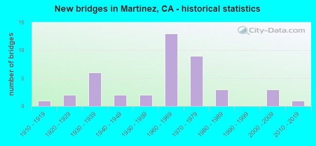
- New bridges - historical statistics
- 11910-1919
- 21920-1929
- 61930-1939
- 21940-1949
- 21950-1959
- 131960-1969
- 91970-1979
- 31980-1989
- 32000-2009
- 12010-2019

- Reconstructed bridges - Historical Statistics
- 11960-1969
- 41970-1979
- 11980-1989


- Bridge Condition - Deck
- 63.6%Good
- 18.2%Satisfactory
- 13.6%Fair
- 4.5%Poor

- Bridge Condition - Superstructure
- 75.0%Good
- 8.3%Satisfactory
- 16.7%Fair

- Bridge Condition - Substructure
- 83.3%Good
- 12.5%Fair
- 4.2%Poor

- Bridge Condition - Channel
- 31.3%Excellent
- 25.0%Very good
- 12.5%Good
- 18.8%Satisfactory
- 12.5%Fair

- Bridge Condition - Culverts
- 25.0%Good
- 75.0%Satisfactory
Find on map >> Show street view
Structure Number: 28 0064, Location: 04-CC-004-R8.85-MTZ (Lat: 37.992114, Lng: -122.124956), Route carried "on" structure: State highway 4, Year Built: 1967, Year Reconstructed: 1975, Status: Open, Structure Length: 2.28m (7.48ft), Average Daily Traffic: 62,000 (year 2018), Truck Traffic: 7%, Average Future Daily Traffic: 127,639 (year 2042), Design Load: HS 20, Features Intersected: ABANDONED BNSF RY SPUR
Minimum Vertical Clearance: 30+ m (98+ ft), Kilometerpoint: 8.850, Lanes on structure: 7, Base Highway Network: Yes (, Subroute: 1), Owner: State Highway Agency, Approaching Roadway Width: 34.0m (111.5ft), Skew: 24 degrees, Material/Design: Concrete, Design/Construction: Slab, Number Of Spans In Main Unit: 1, Length of Maximum Span: 22.8m (74.8ft), Curb-To-Curb Width: 34.0m (111.5ft), Out-to-Out Width: 45.6m (149.6ft)
Condition: Deck: Good, Superstructure: Good, Substructure: Good, Operating Rating: 59.8 metric tons, Method Used To Determine Operating Rating: Load Factor (LF), Inventory Rating: 36.3 metric tons, Method Used To Determine Inventory Rating: Load Factor (LF), Structural Evaluation: Better than present minimum criteria, Deck Geometry: Superior to present desirable criteria, Underclear: Meets minimum limits, Approach Roadway Alignment: Equal to present desirable criteria, Designated Inspection Frequency: Every 24 months, Inspection Date: June 2020, Deck Structure Type: Concrete Cast-file-Place, Wearing Surface/Protective System: Wearing Surface: Bituminous
Find on map >> Show street view
Structure Number: 28 0153L, Location: 04-CC-680-25.04L-MTZ (Lat: 38.033219, Lng: -122.117283), Route carried "on" structure: Interstate 680, Year Built: 1962, Year Reconstructed: 1991, Status: Open, Structure Length: 189.43m (621.49ft), Average Daily Traffic: 115,000 (year 2015), Truck Traffic: 8%, Average Future Daily Traffic: 115,000 (year 2038), Design Load: HS 20, Features Intersected: UP,BNSF,AMTRAK,SUISUN BA
Minimum Vertical Clearance: 30+ m (98+ ft), Kilometerpoint: 25.040, Lanes on structure: 4, Lanes under structure: 4, Base Highway Network: Yes (Inventory Route: 6, Subroute: 1), Toll: Toll bridge, Owner: State Highway Agency, Approaching Roadway Width: 27.4m (89.9ft), Navigation Control: Yes ( Vertical Clearance: 41.1m (134.8ft), Horizontal Clearance: 134.1m (440.0ft)), Material/Design: Steel, Design/Construction: Truss - Deck, Number Of Spans In Main Unit: 10, Number Of Approach Spans: 8, Length of Maximum Span: 160.9m (527.9ft), Curb-To-Curb Width: 18.5m (60.7ft), Out-to-Out Width: 23.6m (77.4ft)
Condition: Deck: Good, Superstructure: Fair, Substructure: Good, Channel: Very good, Operating Rating: 34.7 metric tons, Method Used To Determine Operating Rating: Load Factor (LF), Inventory Rating: 20.7 metric tons, Method Used To Determine Inventory Rating: Load Factor (LF), Structural Evaluation: Somewhat better than minimum adequacy, Deck Geometry: Meets minimum limits, Underclear: High priority of corrective action, Waterway Adequacy: Superior to present desirable criteria, Approach Roadway Alignment: Equal to present desirable criteria, Designated Inspection Frequency: Every 24 months, Critical Feature Inspection Frequency: Every 24 months, Underwater Inspection Frequency: Every 72 months, Inspection Date: September 2021, Critical Feature Inspection Date: November 2021, Underwater Inspection Date: October 2019, Deck Structure Type: Concrete Cast-file-Place, Wearing Surface/Protective System: Wearing Surface: Monolithic Concrete
Find on map >> Show street view
Structure Number: 28 0153R, Location: 04-CC-680-R25.04R-MTZ (Lat: 38.031817, Lng: -122.116639), Route carried "on" structure: Interstate 680, Year Built: 2007, Status: Open, Structure Length: 226.59m (743.41ft), Average Daily Traffic: 105,000 (year 2014), Truck Traffic: 8%, Average Future Daily Traffic: 85,965 (year 2039), Design Load: HS 20+Mod, Features Intersected: UP,BNSF,AMTRAK,SUISUN BA
Minimum Vertical Clearance: 5.62m (18.44ft), Kilometerpoint: 25.040, Lanes on structure: 5, Lanes under structure: 2, Base Highway Network: Yes (Inventory Route: 6, Subroute: 1), Toll: Toll bridge, Owner: State Highway Agency, Approaching Roadway Width: 24.0m (78.7ft), Navigation Control: Yes ( Vertical Clearance: 43.0m (141.1ft), Horizontal Clearance: 170.0m (557.7ft)), Material/Design: Prestressed concrete continuous, Design/Construction: Segmental Box Girder, Number Of Spans In Main Unit: 16, Number Of Approach Spans: 6, Length of Maximum Span: 200.8m (658.8ft), Curb-To-Curb Width: 24.0m (78.7ft), Out-to-Out Width: 25.1m (82.3ft)
Condition: Deck: Good, Superstructure: Good, Substructure: Good, Channel: Very good, Operating Rating: 54.1 metric tons, Method Used To Determine Operating Rating: Assigned rating based on Load Factor Design (LFD) reported in metric tons, Inventory Rating: 32.4 metric tons, Method Used To Determine Inventory Rating: Assigned rating based on Load Factor Design (LFD) reported in metric tons, Structural Evaluation: Better than present minimum criteria, Deck Geometry: Equal to present minimum criteria, Waterway Adequacy: Equal to present desirable criteria, Approach Roadway Alignment: Equal to present desirable criteria, Designated Inspection Frequency: Every 24 months, Critical Feature Inspection Frequency: Every 24 months, Underwater Inspection Frequency: Every 72 months, Inspection Date: August 2021, Critical Feature Inspection Date: August 2021, Underwater Inspection Date: August 2019, Deck Structure Type: Concrete Cast-file-Place, Wearing Surface/Protective System: Wearing Surface: Integral Concrete
Find on map >> Show street view
Structure Number: 28 0171S, Location: 04-CC-680-24.30 (Lat: 38.024306, Lng: -122.112472), Route carried "on" structure: Ramp State highway 680, Year Built: 2016, Status: Open, Structure Length: 22.39m (73.46ft), Average Daily Traffic: 2,650 (year 2012), Truck Traffic: 15%, Average Future Daily Traffic: 3,526 (year 2043), Design Load: HL 93, Features Intersected: MARSH WETLANDS
Minimum Vertical Clearance: 30+ m (98+ ft), Kilometerpoint: 24.300, Lanes on structure: 1, Owner: State Highway Agency, Approaching Roadway Width: 8.7m (28.5ft), Material/Design: Concrete continuous, Design/Construction: Box Beam or Girders - Multiple, Number Of Spans In Main Unit: 11, Number Of Approach Spans: 1, Length of Maximum Span: 30.5m (100.1ft), Curb-To-Curb Width: 8.7m (28.5ft), Out-to-Out Width: 9.6m (31.5ft)
Condition: Deck: Good, Superstructure: Good, Substructure: Good, Channel: Excellent, Operating Rating: 54.1 metric tons, Method Used To Determine Operating Rating: Field evaluation and documented engineering judgment, Inventory Rating: 32.4 metric tons, Method Used To Determine Inventory Rating: Field evaluation and documented engineering judgment, Structural Evaluation: Better than present minimum criteria, Deck Geometry: Superior to present desirable criteria, Waterway Adequacy: Superior to present desirable criteria, Approach Roadway Alignment: Equal to present desirable criteria, Designated Inspection Frequency: Every 24 months, Inspection Date: January 2021, Deck Structure Type: Concrete Cast-file-Place
Find on map >> Show street view
Structure Number: 28 021, Location: 04-CC-680-R0.01-SRMN (Lat: 37.723322, Lng: -121.940506), Route carried "on" structure: City street , Year Built: 1965, Status: Open, Structure Length: 7.32m (24.02ft), Average Daily Traffic: 23,975 (year 1998), Truck Traffic: 3%, Average Future Daily Traffic: 38,479 (year 2038), Design Load: HS 20+Mod, Features Intersected: INTERSTATE 680, Facility Carried by Structure: ALCOSTA BOULEVARD
Minimum Vertical Clearance: 30+ m (98+ ft), Kilometerpoint: 0.000, Lanes on structure: 5, Lanes under structure: 9, Owner: State Highway Agency, Approaching Roadway Width: 20.7m (67.9ft), Skew: 21 degrees, Material/Design: Concrete continuous, Design/Construction: Box Beam or Girders - Multiple, Number Of Spans In Main Unit: 4, Length of Maximum Span: 22.9m (75.1ft), Curb or Sidewalk Widths: Left: 1.8m (5.9ft), Right: 1.8m (5.9ft), Curb-To-Curb Width: 20.7m (67.9ft), Out-to-Out Width: 25.0m (82.0ft)
Condition: Deck: Good, Superstructure: Good, Substructure: Good, Operating Rating: 36.0 metric tons, Method Used To Determine Operating Rating: Load and Resistance Factor Rating (LRFR) rating reported by rating factor(RF) method using HL-93 loadings, Inventory Rating: 27.5 metric tons, Method Used To Determine Inventory Rating: Load and Resistance Factor Rating (LRFR) rating reported by rating factor(RF) method using HL-93 loadings, Structural Evaluation: Equal to present minimum criteria, Deck Geometry: Somewhat better than minimum adequacy, Underclear: Meets minimum limits, Approach Roadway Alignment: Equal to present desirable criteria, Designated Inspection Frequency: Every 24 months, Inspection Date: July 2020, Deck Structure Type: Concrete Cast-file-Place, Wearing Surface/Protective System: Wearing Surface: Bituminous
Find on map >> Show street view
Structure Number: 28 0212, Location: 04-CC-004-R9.18-MTZ (Lat: 37.995200, Lng: -122.120528), Route carried "on" structure: City street , Year Built: 1975, Status: Open, Structure Length: 7.01m (23.00ft), Average Daily Traffic: 22,000 (year 2018), Truck Traffic: 1%, Average Future Daily Traffic: 37,408 (year 2042), Design Load: HS 20, Features Intersected: STATE ROUTE 4, Facility Carried by Structure: CENTER AVENUE
Minimum Vertical Clearance: 30+ m (98+ ft), Kilometerpoint: 0.000, Lanes on structure: 7, Lanes under structure: 6, Owner: State Highway Agency, Approaching Roadway Width: 32.6m (107.0ft), Skew: 21 degrees, Material/Design: Prestressed concrete continuous, Design/Construction: Box Beam or Girders - Multiple, Number Of Spans In Main Unit: 2, Length of Maximum Span: 36.9m (121.1ft), Curb or Sidewalk Widths: Left: 0.0m, Right: 1.5m (4.9ft), Curb-To-Curb Width: 31.2m (102.4ft), Out-to-Out Width: 34.8m (114.2ft)
Condition: Deck: Fair, Superstructure: Fair, Substructure: Good, Operating Rating: 45.7 metric tons, Method Used To Determine Operating Rating: Load and Resistance Factor Rating (LRFR) rating reported by rating factor(RF) method using HL-93 loadings, Inventory Rating: 35.0 metric tons, Method Used To Determine Inventory Rating: Load and Resistance Factor Rating (LRFR) rating reported by rating factor(RF) method using HL-93 loadings, Structural Evaluation: Somewhat better than minimum adequacy, Deck Geometry: Better than present minimum criteria, Underclear: Equal to present minimum criteria, Approach Roadway Alignment: Equal to present desirable criteria, Designated Inspection Frequency: Every 24 months, Inspection Date: June 2020, Deck Structure Type: Concrete Cast-file-Place
Find on map >> Show street view
Structure Number: 28 0214L, Location: 04-CC-004-R8.55-MTZ (Lat: 37.990622, Lng: -122.130294), Route carried "on" structure: State highway 4, Year Built: 1967, Year Reconstructed: 1975, Status: Open, Structure Length: 5.24m (17.19ft), Average Daily Traffic: 31,000 (year 2018), Truck Traffic: 7%, Average Future Daily Traffic: 63,819 (year 2042), Design Load: HS 20, Features Intersected: ALHAMBRA AVE
Minimum Vertical Clearance: 30+ m (98+ ft), Kilometerpoint: 8.550, Lanes on structure: 3, Lanes under structure: 6, Base Highway Network: Yes (, Subroute: 1), Owner: State Highway Agency, Approaching Roadway Width: 14.9m (48.9ft), Material/Design: Concrete continuous, Design/Construction: Box Beam or Girders - Multiple, Number Of Spans In Main Unit: 3, Length of Maximum Span: 31.7m (104.0ft), Curb-To-Curb Width: 15.0m (49.2ft), Out-to-Out Width: 15.8m (51.8ft)
Condition: Deck: Satisfactory, Superstructure: Good, Substructure: Good, Operating Rating: 54.1 metric tons, Method Used To Determine Operating Rating: Load and Resistance Factor Rating (LRFR) rating reported by rating factor(RF) method using HL-93 loadings, Inventory Rating: 41.8 metric tons, Method Used To Determine Inventory Rating: Load and Resistance Factor Rating (LRFR) rating reported by rating factor(RF) method using HL-93 loadings, Structural Evaluation: Better than present minimum criteria, Deck Geometry: Meets minimum limits, Underclear: Somewhat better than minimum adequacy, Approach Roadway Alignment: Equal to present desirable criteria, Designated Inspection Frequency: Every 24 months, Inspection Date: May 2020, Deck Structure Type: Concrete Cast-file-Place
Find on map >> Show street view
Structure Number: 28 0214R, Location: 04-CC-004-R8.55-MTZ (Lat: 37.990467, Lng: -122.130211), Route carried "on" structure: State highway 4, Year Built: 1967, Status: Open, Structure Length: 5.24m (17.19ft), Average Daily Traffic: 31,000 (year 2018), Truck Traffic: 7%, Average Future Daily Traffic: 63,819 (year 2042), Design Load: HS 20, Features Intersected: ALHAMBRA AVE
Minimum Vertical Clearance: 30+ m (98+ ft), Kilometerpoint: 8.550, Lanes on structure: 2, Lanes under structure: 6, Base Highway Network: Yes (, Subroute: 1), Owner: State Highway Agency, Approaching Roadway Width: 11.3m (37.1ft), Material/Design: Concrete continuous, Design/Construction: Box Beam or Girders - Multiple, Number Of Spans In Main Unit: 3, Length of Maximum Span: 31.7m (104.0ft), Curb-To-Curb Width: 11.0m (36.1ft), Out-to-Out Width: 11.6m (38.1ft)
Condition: Deck: Satisfactory, Superstructure: Good, Substructure: Good, Operating Rating: 35.0 metric tons, Method Used To Determine Operating Rating: Load and Resistance Factor Rating (LRFR) rating reported by rating factor(RF) method using HL-93 loadings, Inventory Rating: 26.9 metric tons, Method Used To Determine Inventory Rating: Load and Resistance Factor Rating (LRFR) rating reported by rating factor(RF) method using HL-93 loadings, Structural Evaluation: Equal to present minimum criteria, Deck Geometry: Somewhat better than minimum adequacy, Underclear: Somewhat better than minimum adequacy, Approach Roadway Alignment: Equal to present desirable criteria, Designated Inspection Frequency: Every 24 months, Inspection Date: May 2020, Deck Structure Type: Concrete Cast-file-Place
Find on map >> Show street view
Structure Number: 28 0216L, Location: 04-CC-004-R8.75-MTZ (Lat: 37.991428, Lng: -122.126764), Route carried "on" structure: State highway 4, Year Built: 1967, Year Reconstructed: 1975, Status: Open, Structure Length: 5.82m (19.09ft), Average Daily Traffic: 31,000 (year 2018), Truck Traffic: 7%, Average Future Daily Traffic: 63,819 (year 2042), Design Load: HS 20, Features Intersected: ALHAMBRA WAY
Minimum Vertical Clearance: 30+ m (98+ ft), Kilometerpoint: 8.750, Lanes on structure: 4, Lanes under structure: 2, Base Highway Network: Yes (, Subroute: 1), Owner: State Highway Agency, Approaching Roadway Width: 17.7m (58.1ft), Material/Design: Concrete continuous, Design/Construction: Tee Beam, Number Of Spans In Main Unit: 3, Length of Maximum Span: 20.4m (66.9ft), Curb-To-Curb Width: 17.7m (58.1ft), Out-to-Out Width: 18.3m (60.0ft)
Condition: Deck: Satisfactory, Superstructure: Good, Substructure: Good, Channel: Excellent, Operating Rating: 35.6 metric tons, Method Used To Determine Operating Rating: Load and Resistance Factor Rating (LRFR) rating reported by rating factor(RF) method using HL-93 loadings, Inventory Rating: 27.5 metric tons, Method Used To Determine Inventory Rating: Load and Resistance Factor Rating (LRFR) rating reported by rating factor(RF) method using HL-93 loadings, Structural Evaluation: Equal to present minimum criteria, Deck Geometry: Meets minimum limits, Underclear: Somewhat better than minimum adequacy, Waterway Adequacy: Meets minimum limits, Approach Roadway Alignment: Equal to present desirable criteria, Designated Inspection Frequency: Every 24 months, Inspection Date: May 2020, Deck Structure Type: Concrete Cast-file-Place
Find on map >> Show street view
Structure Number: 28 0216R, Location: 04-CC-004-R8.75-MTZ (Lat: 37.991208, Lng: -122.126639), Route carried "on" structure: State highway 4, Year Built: 1967, Year Reconstructed: 1975, Status: Open, Structure Length: 5.82m (19.09ft), Average Daily Traffic: 31,000 (year 2018), Truck Traffic: 7%, Average Future Daily Traffic: 63,819 (year 2042), Design Load: HS 20, Features Intersected: ALHAMBRA WAY
Minimum Vertical Clearance: 30+ m (98+ ft), Kilometerpoint: 8.750, Lanes on structure: 3, Lanes under structure: 2, Base Highway Network: Yes (, Subroute: 1), Owner: State Highway Agency, Approaching Roadway Width: 16.5m (54.1ft), Material/Design: Concrete continuous, Design/Construction: Tee Beam, Number Of Spans In Main Unit: 3, Length of Maximum Span: 20.4m (66.9ft), Curb-To-Curb Width: 15.5m (50.9ft), Out-to-Out Width: 16.1m (52.8ft)
Condition: Deck: Satisfactory, Superstructure: Good, Substructure: Good, Channel: Excellent, Operating Rating: 31.4 metric tons, Method Used To Determine Operating Rating: Load and Resistance Factor Rating (LRFR) rating reported by rating factor(RF) method using HL-93 loadings, Inventory Rating: 24.3 metric tons, Method Used To Determine Inventory Rating: Load and Resistance Factor Rating (LRFR) rating reported by rating factor(RF) method using HL-93 loadings, Structural Evaluation: Equal to present minimum criteria, Deck Geometry: Somewhat better than minimum adequacy, Underclear: Somewhat better than minimum adequacy, Waterway Adequacy: Meets minimum limits, Approach Roadway Alignment: Equal to present desirable criteria, Designated Inspection Frequency: Every 24 months, Inspection Date: May 2020, Deck Structure Type: Concrete Cast-file-Place
Find on map >> Show street view
Structure Number: 28 0217, Location: 04-CC-004-R11.13-MTZ (Lat: 37.991522, Lng: -122.086633), Route carried "on" structure: City street , Year Built: 1975, Status: Open, Structure Length: 9.48m (31.10ft), Average Daily Traffic: 5,500 (year 2018), Truck Traffic: 1%, Average Future Daily Traffic: 8,755 (year 2042), Design Load: HS 20, Features Intersected: STATE ROUTE 4, Facility Carried by Structure: MILANO WAY
Minimum Vertical Clearance: 30+ m (98+ ft), Kilometerpoint: 0.000, Lanes on structure: 2, Lanes under structure: 6, Owner: State Highway Agency, Approaching Roadway Width: 12.2m (40.0ft), Skew: 2 degrees, Material/Design: Prestressed concrete continuous, Design/Construction: Box Beam or Girders - Multiple, Number Of Spans In Main Unit: 2, Length of Maximum Span: 48.5m (159.1ft), Curb or Sidewalk Widths: Left: 1.5m (4.9ft), Right: 1.5m (4.9ft), Curb-To-Curb Width: 12.2m (40.0ft), Out-to-Out Width: 15.8m (51.8ft)
Condition: Deck: Good, Superstructure: Good, Substructure: Good, Operating Rating: 55.7 metric tons, Method Used To Determine Operating Rating: Load and Resistance Factor Rating (LRFR) rating reported by rating factor(RF) method using HL-93 loadings, Inventory Rating: 36.9 metric tons, Method Used To Determine Inventory Rating: Load and Resistance Factor Rating (LRFR) rating reported by rating factor(RF) method using HL-93 loadings, Structural Evaluation: Better than present minimum criteria, Deck Geometry: Somewhat better than minimum adequacy, Underclear: Somewhat better than minimum adequacy, Approach Roadway Alignment: Equal to present minimum criteria, Designated Inspection Frequency: Every 24 months, Inspection Date: June 2020, Deck Structure Type: Concrete Cast-file-Place
Find on map >> Show street view
Structure Number: 28 0218L, Location: 04-CC-004-R10.33-MTZ (Lat: 37.992036, Lng: -122.101008), Route carried "on" structure: State highway 4, Year Built: 1975, Status: Open, Structure Length: 5.36m (17.59ft), Average Daily Traffic: 31,000 (year 2018), Truck Traffic: 7%, Average Future Daily Traffic: 63,819 (year 2042), Design Load: HS 20, Features Intersected: MORELLO AVE
Minimum Vertical Clearance: 30+ m (98+ ft), Kilometerpoint: 10.330, Lanes on structure: 3, Lanes under structure: 7, Base Highway Network: Yes (, Subroute: 1), Owner: State Highway Agency, Approaching Roadway Width: 15.8m (51.8ft), Skew: 2 degrees, Material/Design: Prestressed concrete, Design/Construction: Box Beam or Girders - Multiple, Number Of Spans In Main Unit: 1, Length of Maximum Span: 53.6m (175.9ft), Curb-To-Curb Width: 19.2m (63.0ft), Out-to-Out Width: 19.8m (65.0ft)
Condition: Deck: Good, Superstructure: Good, Substructure: Good, Operating Rating: 64.8 metric tons, Method Used To Determine Operating Rating: Load and Resistance Factor Rating (LRFR) rating reported by rating factor(RF) method using HL-93 loadings, Inventory Rating: 39.5 metric tons, Method Used To Determine Inventory Rating: Load and Resistance Factor Rating (LRFR) rating reported by rating factor(RF) method using HL-93 loadings, Structural Evaluation: Better than present minimum criteria, Deck Geometry: Superior to present desirable criteria, Underclear: Equal to present minimum criteria, Approach Roadway Alignment: Equal to present desirable criteria, Designated Inspection Frequency: Every 24 months, Inspection Date: June 2020, Deck Structure Type: Concrete Cast-file-Place
Find on map >> Show street view
Structure Number: 28 0218R, Location: 04-CC-004-R10.33-MTZ (Lat: 37.991753, Lng: -122.101036), Route carried "on" structure: State highway 4, Year Built: 1975, Status: Open, Structure Length: 5.36m (17.59ft), Average Daily Traffic: 31,000 (year 2018), Truck Traffic: 7%, Average Future Daily Traffic: 63,819 (year 2042), Design Load: HS 20, Features Intersected: MORELLO AVE
Minimum Vertical Clearance: 30+ m (98+ ft), Kilometerpoint: 10.330, Lanes on structure: 3, Lanes under structure: 7, Base Highway Network: Yes (, Subroute: 1), Owner: State Highway Agency, Approaching Roadway Width: 15.6m (51.2ft), Skew: 2 degrees, Material/Design: Prestressed concrete, Design/Construction: Box Beam or Girders - Multiple, Number Of Spans In Main Unit: 1, Length of Maximum Span: 53.6m (175.9ft), Curb-To-Curb Width: 15.6m (51.2ft), Out-to-Out Width: 16.2m (53.1ft)
Condition: Deck: Good, Superstructure: Good, Substructure: Good, Operating Rating: 59.0 metric tons, Method Used To Determine Operating Rating: Load and Resistance Factor Rating (LRFR) rating reported by rating factor(RF) method using HL-93 loadings, Inventory Rating: 36.6 metric tons, Method Used To Determine Inventory Rating: Load and Resistance Factor Rating (LRFR) rating reported by rating factor(RF) method using HL-93 loadings, Structural Evaluation: Better than present minimum criteria, Deck Geometry: Somewhat better than minimum adequacy, Underclear: Equal to present minimum criteria, Approach Roadway Alignment: Equal to present desirable criteria, Designated Inspection Frequency: Every 24 months, Inspection Date: June 2020, Deck Structure Type: Concrete Cast-file-Place
Find on map >> Show street view
Structure Number: 28 0235, Location: 04-CC-004-R7.27 (Lat: 37.998964, Lng: -122.146647), Route carried "on" structure: State highway 4, Year Built: 1967, Status: Open, Structure Length: 0.63m (2.07ft), Average Daily Traffic: 55,000 (year 2018), Truck Traffic: 8%, Average Future Daily Traffic: 59,981 (year 2042), Features Intersected: FRANKLIN EQUIP & PIPE UC
Minimum Vertical Clearance: 30+ m (98+ ft), Kilometerpoint: 7.270, Lanes on structure: 4, Base Highway Network: Yes (, Subroute: 1), Owner: State Highway Agency, Approaching Roadway Width: 22.4m (73.5ft), Skew: 20 degrees, Material/Design: Steel, Design/Construction: Arch - Deck, Number Of Spans In Main Unit: 1, Length of Maximum Span: 6.3m (20.7ft)
Condition: Superstructure: Fair, Substructure: Good, Operating Rating: 54.1 metric tons, Method Used To Determine Operating Rating: Field evaluation and documented engineering judgment, Inventory Rating: 32.4 metric tons, Method Used To Determine Inventory Rating: Field evaluation and documented engineering judgment, Structural Evaluation: Somewhat better than minimum adequacy, Approach Roadway Alignment: Equal to present desirable criteria, Designated Inspection Frequency: Every 24 months, Inspection Date: May 2020
Find on map >> Show street view
Structure Number: 28 0361L, Location: 04-CC-004-R3.87L-MTZ (Lat: 38.009089, Lng: -122.206300), Route carried "on" structure: State highway 4, Year Built: 2002, Status: Open, Structure Length: 0.67m (2.20ft), Average Daily Traffic: 10,200 (year 2018), Truck Traffic: 6%, Average Future Daily Traffic: 12,319 (year 2042), Design Load: HS 20+Mod, Features Intersected: PRIVATE ACCESS ROAD
Minimum Vertical Clearance: 30+ m (98+ ft), Kilometerpoint: 3.870, Lanes on structure: 2, Base Highway Network: Yes, Owner: State Highway Agency, Approaching Roadway Width: 16.8m (55.1ft), Material/Design: Steel, Design/Construction: Arch - Deck, Number Of Spans In Main Unit: 1, Length of Maximum Span: 6.7m (22.0ft), Curb-To-Curb Width: 16.8m (55.1ft), Out-to-Out Width: 17.4m (57.1ft)
Condition: Superstructure: Good, Substructure: Good, Operating Rating: 54.1 metric tons, Method Used To Determine Operating Rating: Field evaluation and documented engineering judgment, Inventory Rating: 32.4 metric tons, Method Used To Determine Inventory Rating: Field evaluation and documented engineering judgment, Structural Evaluation: Better than present minimum criteria, Deck Geometry: Superior to present desirable criteria, Approach Roadway Alignment: Equal to present desirable criteria, Designated Inspection Frequency: Every 24 months, Inspection Date: May 2020
Find on map >> Show street view
Structure Number: 28C0002, Location: AT CASTRO STREET (Lat: 38.017544, Lng: -122.137611), Route carried "on" structure: City street , Year Built: 1987, Status: Open, Structure Length: 1.52m (4.99ft), Average Daily Traffic: 4,900 (year 1980), Truck Traffic: 2%, Average Future Daily Traffic: 9,781 (year 2037), Features Intersected: ARROYO DEL HAMBRE, Facility Carried by Structure: ESCOBAR ST
Minimum Vertical Clearance: 30+ m (98+ ft), Kilometerpoint: 0.000, Lanes on structure: 2, Base Highway Network: Yes, Owner: City or Municipal Highway Agency, Approaching Roadway Width: 10.7m (35.1ft), Skew: 3 degrees, Material/Design: Prestressed concrete, Design/Construction: Slab, Number Of Spans In Main Unit: 1, Length of Maximum Span: 13.3m (43.6ft), Curb or Sidewalk Widths: Left: 1.8m (5.9ft), Right: 1.8m (5.9ft), Curb-To-Curb Width: 11.0m (36.1ft), Out-to-Out Width: 15.2m (49.9ft)
Condition: Deck: Good, Superstructure: Good, Substructure: Good, Channel: Good, Operating Rating: 54.1 metric tons, Method Used To Determine Operating Rating: Field evaluation and documented engineering judgment, Inventory Rating: 32.4 metric tons, Method Used To Determine Inventory Rating: Field evaluation and documented engineering judgment, Structural Evaluation: Better than present minimum criteria, Deck Geometry: Somewhat better than minimum adequacy, Waterway Adequacy: Better than present minimum criteria, Approach Roadway Alignment: Equal to present minimum criteria, Designated Inspection Frequency: Every 48 months, Inspection Date: Febuary 2019, Deck Structure Type: Concrete Cast-file-Place, Wearing Surface/Protective System: Wearing Surface: Bituminous
Find on map >> Show street view
Structure Number: 28C0006, Location: 0.3 MI WEST SOLANO WAY (Lat: 38.031278, Lng: -122.081722), Route carried "on" structure: County highway , Year Built: 1948, Year Reconstructed: 1965, Status: Open, Structure Length: 22.95m (75.30ft), Average Daily Traffic: 2,409 (year 2013), Truck Traffic: 12%, Average Future Daily Traffic: 5,101 (year 2037), Design Load: HS 20, Features Intersected: PACHECO SLOUGH, Facility Carried by Structure: WATERFRONT RD
Minimum Vertical Clearance: 30+ m (98+ ft), Kilometerpoint: 0.000, Lanes on structure: 2, Owner: County Highway Agency, Approaching Roadway Width: 10.4m (34.1ft), Skew: 9 degrees, Navigation Control: Yes ( Vertical Clearance: 1.2m (3.9ft), Horizontal Clearance: 20.1m (65.9ft)), Material/Design: Steel continuous, Design/Construction: Stringer/Multi-beam, Number Of Spans In Main Unit: 2, Number Of Approach Spans: 16, Length of Maximum Span: 26.9m (88.3ft), Curb-To-Curb Width: 9.3m (30.5ft), Out-to-Out Width: 10.4m (34.1ft)
Condition: Deck: Good, Superstructure: Good, Substructure: Fair, Channel: Satisfactory, Operating Rating: 42.1 metric tons, Method Used To Determine Operating Rating: Load Factor (LF), Inventory Rating: 25.3 metric tons, Method Used To Determine Inventory Rating: Load Factor (LF), Structural Evaluation: Somewhat better than minimum adequacy, Deck Geometry: Meets minimum limits, Waterway Adequacy: Equal to present minimum criteria, Approach Roadway Alignment: Equal to present minimum criteria, Designated Inspection Frequency: Every 24 months, Underwater Inspection Frequency: Every 60 months, Inspection Date: September 2020, Underwater Inspection Date: April 2018, Deck Structure Type: Concrete Cast-file-Place
Find on map >> Show street view
Structure Number: 28C0084, Location: AT MUIR TUNNEL (Lat: 37.996711, Lng: -122.119614), Route carried "on" structure: City street , Year Built: 1975, Status: Open, Structure Length: 3.20m (10.50ft), Average Daily Traffic: 3,000 (year 2000), Truck Traffic: 2%, Average Future Daily Traffic: 4,534 (year 2041), Features Intersected: BNSF RY, Facility Carried by Structure: ARNOLD DRIVE
Minimum Vertical Clearance: 30+ m (98+ ft), Kilometerpoint: 0.000, Lanes on structure: 2, Owner: City or Municipal Highway Agency, Approaching Roadway Width: 12.2m (40.0ft), Material/Design: Prestressed concrete, Design/Construction: Box Beam or Girders - Multiple, Number Of Spans In Main Unit: 1, Length of Maximum Span: 31.7m (104.0ft), Curb or Sidewalk Widths: Left: 1.5m (4.9ft), Right: 0.0m, Curb-To-Curb Width: 12.2m (40.0ft), Out-to-Out Width: 14.3m (46.9ft)
Condition: Deck: Fair, Superstructure: Satisfactory, Substructure: Fair, Operating Rating: 46.3 metric tons, Method Used To Determine Operating Rating: Load and Resistance Factor Rating (LRFR) rating reported by rating factor(RF) method using HL-93 loadings, Inventory Rating: 33.4 metric tons, Method Used To Determine Inventory Rating: Load and Resistance Factor Rating (LRFR) rating reported by rating factor(RF) method using HL-93 loadings, Structural Evaluation: Somewhat better than minimum adequacy, Deck Geometry: Equal to present minimum criteria, Underclear: Equal to present minimum criteria, Approach Roadway Alignment: Equal to present minimum criteria, Designated Inspection Frequency: Every 24 months, Inspection Date: Febuary 2021, Deck Structure Type: Concrete Cast-file-Place
Find on map >> Show street view
Structure Number: 28C0142, Location: 3 MI E MORGAN TERITORY RD (Lat: 37.884714, Lng: -121.831811), Route carried "on" structure: County highway , Year Built: 1937, Status: Open, Structure Length: 1.24m (4.07ft), Average Daily Traffic: 5,637 (year 2013), Truck Traffic: 7%, Average Future Daily Traffic: 8,438 (year 2037), Features Intersected: MARSH CREEK, Facility Carried by Structure: MARSH CREEK RD
Minimum Vertical Clearance: 30+ m (98+ ft), Kilometerpoint: 0.000, Lanes on structure: 2, Owner: County Highway Agency, Approaching Roadway Width: 9.8m (32.2ft), Skew: 4 degrees, Material/Design: Concrete continuous, Design/Construction: Culvert, Number Of Spans In Main Unit: 2, Length of Maximum Span: 5.7m (18.7ft)
Condition: Channel: Excellent, Culverts: Satisfactory, Operating Rating: 27.2 metric tons, Method Used To Determine Operating Rating: Field evaluation and documented engineering judgment, Inventory Rating: 16.2 metric tons, Method Used To Determine Inventory Rating: Field evaluation and documented engineering judgment, Structural Evaluation: Meets minimum limits, Waterway Adequacy: Equal to present minimum criteria, Approach Roadway Alignment: Meets minimum limits, Designated Inspection Frequency: Every 24 months, Inspection Date: July 2020
Find on map >> Show street view
Structure Number: 28C0184, Location: AT CASTRO ST (Lat: 38.017947, Lng: -122.138453), Route carried "on" structure: City street , Year Built: 1989, Status: Open, Structure Length: 1.65m (5.41ft), Average Daily Traffic: 4,500 (year 1985), Truck Traffic: 5%, Average Future Daily Traffic: 8,694 (year 2037), Design Load: HS 20+Mod, Features Intersected: ARROYO DEL HAMBRE, Facility Carried by Structure: MARINA VISTA AVE
Minimum Vertical Clearance: 30+ m (98+ ft), Kilometerpoint: 0.000, Lanes on structure: 3, Base Highway Network: Yes, Owner: City or Municipal Highway Agency, Approaching Roadway Width: 9.1m (29.9ft), Skew: 3 degrees, Material/Design: Prestressed concrete, Design/Construction: Slab, Number Of Spans In Main Unit: 1, Length of Maximum Span: 14.9m (48.9ft), Curb or Sidewalk Widths: Left: 1.8m (5.9ft), Right: 1.8m (5.9ft), Curb-To-Curb Width: 11.0m (36.1ft), Out-to-Out Width: 15.2m (49.9ft)
Condition: Deck: Good, Superstructure: Good, Substructure: Good, Channel: Very good, Operating Rating: 54.1 metric tons, Method Used To Determine Operating Rating: Assigned rating based on Load Factor Design (LFD) reported in metric tons, Inventory Rating: 32.4 metric tons, Method Used To Determine Inventory Rating: Assigned rating based on Load Factor Design (LFD) reported in metric tons, Structural Evaluation: Better than present minimum criteria, Deck Geometry: High priority of replacement, Waterway Adequacy: Equal to present desirable criteria, Approach Roadway Alignment: Equal to present minimum criteria, Designated Inspection Frequency: Every 48 months, Inspection Date: Febuary 2019, Deck Structure Type: Concrete Cast-file-Place, Wearing Surface/Protective System: Wearing Surface: Bituminous
Find on map >> Show street view
Structure Number: 28C0264, Location: AT FERRY STREET (Lat: 38.016372, Lng: -122.135175), Route carried "on" structure: City street , Year Built: 1940, Status: Open, Structure Length: 0.98m (3.22ft), Average Daily Traffic: 3,000 (year 2009), Truck Traffic: 3%, Average Future Daily Traffic: 3,402 (year 2041), Features Intersected: ARROYO DEL HAMBRE, Facility Carried by Structure: GREEN STREET
Minimum Vertical Clearance: 30+ m (98+ ft), Kilometerpoint: 0.000, Lanes on structure: 2, Owner: City or Municipal Highway Agency, Approaching Roadway Width: 12.0m (39.4ft), Skew: 6 degrees, Material/Design: Concrete continuous, Design/Construction: Culvert, Number Of Spans In Main Unit: 2, Length of Maximum Span: 4.8m (15.7ft), Curb or Sidewalk Widths: Left: 1.9m (6.2ft), Right: 2.0m (6.6ft)
Condition: Channel: Very good, Culverts: Good, Operating Rating: 54.8 metric tons, Method Used To Determine Operating Rating: Load Factor (LF), Inventory Rating: 33.0 metric tons, Method Used To Determine Inventory Rating: Load Factor (LF), Structural Evaluation: Better than present minimum criteria, Waterway Adequacy: Equal to present desirable criteria, Approach Roadway Alignment: Equal to present minimum criteria, Designated Inspection Frequency: Every 24 months, Inspection Date: Febuary 2021
Find on map >> Show street view
Structure Number: 28C036, Location: 0.3 MI S CLAYTON RD (Lat: 37.961289, Lng: -121.994531), Route carried "on" structure: City street , Year Built: 1968, Status: Open, Structure Length: 0.76m (2.49ft), Average Daily Traffic: 28,708 (year 1977), Truck Traffic: 5%, Average Future Daily Traffic: 32,065 (year 2038), Features Intersected: GALINDO CREEK, Facility Carried by Structure: TREAT BLVD
Minimum Vertical Clearance: 30+ m (98+ ft), Kilometerpoint: 0.000, Lanes on structure: 4, Base Highway Network: Yes, Owner: City or Municipal Highway Agency, Approaching Roadway Width: 17.0m (55.8ft), Skew: 32 degrees, Material/Design: Concrete continuous, Design/Construction: Culvert, Number Of Spans In Main Unit: 2, Length of Maximum Span: 3.7m (12.1ft)
Condition: Channel: Excellent, Culverts: Satisfactory, Operating Rating: 40.5 metric tons, Method Used To Determine Operating Rating: Field evaluation and documented engineering judgment, Inventory Rating: 24.3 metric tons, Method Used To Determine Inventory Rating: Field evaluation and documented engineering judgment, Structural Evaluation: Equal to present minimum criteria, Waterway Adequacy: Better than present minimum criteria, Approach Roadway Alignment: Equal to present desirable criteria, Designated Inspection Frequency: Every 24 months, Inspection Date: November 2021
Find on map >> Show street view
Structure Number: 28C0367, Location: 300 FT EST OF ALHAMBRA AV (Lat: 38.003547, Lng: -122.129808), Route carried "on" structure: City street , Year Built: 1955, Status: Open, Structure Length: 1.37m (4.49ft), Average Daily Traffic: 4,900 (year 1977), Truck Traffic: 6%, Average Future Daily Traffic: 8,234 (year 2041), Design Load: HS 20, Features Intersected: ARROYO DEL HAMBRE, Facility Carried by Structure: SHELL AVE
Minimum Vertical Clearance: 30+ m (98+ ft), Kilometerpoint: 0.000, Lanes on structure: 2, Owner: City or Municipal Highway Agency, Approaching Roadway Width: 9.8m (32.2ft), Material/Design: Steel, Design/Construction: Stringer/Multi-beam, Number Of Spans In Main Unit: 1, Length of Maximum Span: 13.1m (43.0ft), Curb or Sidewalk Widths: Left: 1.2m (3.9ft), Right: 1.2m (3.9ft), Curb-To-Curb Width: 9.8m (32.2ft), Out-to-Out Width: 12.2m (40.0ft)
Condition: Deck: Poor, Superstructure: Fair, Substructure: Poor, Channel: Fair, Operating Rating: 34.0 metric tons, Method Used To Determine Operating Rating: Load Factor (LF), Inventory Rating: 20.4 metric tons, Method Used To Determine Inventory Rating: Load Factor (LF), Structural Evaluation: Meets minimum limits, Deck Geometry: Meets minimum limits, Waterway Adequacy: Equal to present minimum criteria, Approach Roadway Alignment: Equal to present minimum criteria, Length Of Structure Improvement: 1.37m (4.49ft), Designated Inspection Frequency: Every 24 months, Inspection Date: Febuary 2021, Bridge Improvement Cost: $384,000, Roadway Improvement Cost: $76,000, Total Project Cost: $645,000 ( Estimate for 2017), Deck Structure Type: Concrete Cast-file-Place
Find on map >> Show street view
Structure Number: 28C0368, Location: 0.1 MI W PINE ST (Lat: 38.011328, Lng: -122.129094), Route carried "on" structure: City street , Year Built: 1929, Status: Open, Structure Length: 0.76m (2.49ft), Average Daily Traffic: 3,000 (year 2009), Truck Traffic: 2%, Average Future Daily Traffic: 3,842 (year 2041), Features Intersected: ARROYO DEL HAMBRE, Facility Carried by Structure: BROWN ST
Minimum Vertical Clearance: 30+ m (98+ ft), Kilometerpoint: 0.000, Lanes on structure: 2, Owner: City or Municipal Highway Agency, Approaching Roadway Width: 8.5m (27.9ft), Skew: 3 degrees, Material/Design: Concrete continuous, Design/Construction: Culvert, Number Of Spans In Main Unit: 2, Length of Maximum Span: 3.9m (12.8ft), Curb or Sidewalk Widths: Left: 3.7m (12.1ft), Right: 3.7m (12.1ft), Curb-To-Curb Width: 8.5m (27.9ft), Out-to-Out Width: 16.5m (54.1ft)
Condition: Channel: Fair, Culverts: Satisfactory, Operating Rating: 48.9 metric tons, Method Used To Determine Operating Rating: Load Factor (LF), Inventory Rating: 29.5 metric tons, Method Used To Determine Inventory Rating: Load Factor (LF), Structural Evaluation: Equal to present minimum criteria, Deck Geometry: Meets minimum limits, Waterway Adequacy: Equal to present minimum criteria, Approach Roadway Alignment: Equal to present minimum criteria, Designated Inspection Frequency: Every 24 months, Inspection Date: Febuary 2021
Find on map >> Show street view
Structure Number: 28C0369, Location: AT ESTUDILLO ST (Lat: 38.014206, Lng: -122.133008), Route carried "on" structure: City street , Year Built: 1987, Status: Open, Structure Length: 1.13m (3.71ft), Average Daily Traffic: 1,876 (year 1984), Truck Traffic: 2%, Average Future Daily Traffic: 3,303 (year 2041), Design Load: HS 20+Mod, Features Intersected: ARROYO DEL HAMBRE, Facility Carried by Structure: SUSANA ST
Minimum Vertical Clearance: 30+ m (98+ ft), Kilometerpoint: 0.000, Lanes on structure: 2, Owner: City or Municipal Highway Agency, Approaching Roadway Width: 9.1m (29.9ft), Material/Design: Concrete, Design/Construction: Slab, Number Of Spans In Main Unit: 1, Length of Maximum Span: 10.4m (34.1ft), Curb or Sidewalk Widths: Left: 2.4m (7.9ft), Right: 2.4m (7.9ft), Curb-To-Curb Width: 9.1m (29.9ft), Out-to-Out Width: 14.6m (47.9ft)
Condition: Deck: Fair, Superstructure: Satisfactory, Substructure: Good, Channel: Satisfactory, Operating Rating: 54.1 metric tons, Method Used To Determine Operating Rating: Assigned rating based on Load Factor Design (LFD) reported in metric tons, Inventory Rating: 32.4 metric tons, Method Used To Determine Inventory Rating: Assigned rating based on Load Factor Design (LFD) reported in metric tons, Structural Evaluation: Equal to present minimum criteria, Deck Geometry: Somewhat better than minimum adequacy, Waterway Adequacy: Better than present minimum criteria, Approach Roadway Alignment: Equal to present minimum criteria, Designated Inspection Frequency: Every 24 months, Inspection Date: Febuary 2021, Deck Structure Type: Concrete Cast-file-Place
Find on map >> Show street view
Structure Number: 28C0406, Location: AT ESTUDILLO ST (Lat: 38.016747, Lng: -122.135981), Route carried "on" structure: City street , Year Built: 1958, Status: Open, Structure Length: 1.04m (3.41ft), Average Daily Traffic: 3,300 (year 2009), Truck Traffic: 3%, Average Future Daily Traffic: 3,978 (year 2043), Design Load: HS 20, Features Intersected: ARROYO DEL HAMBRE, Facility Carried by Structure: WARD ST
Minimum Vertical Clearance: 30+ m (98+ ft), Kilometerpoint: 0.000, Lanes on structure: 2, Owner: City or Municipal Highway Agency, Approaching Roadway Width: 11.0m (36.1ft), Skew: 2 degrees, Material/Design: Concrete, Design/Construction: Tee Beam, Number Of Spans In Main Unit: 1, Length of Maximum Span: 9.8m (32.2ft), Curb or Sidewalk Widths: Left: 1.6m (5.2ft), Right: 1.6m (5.2ft), Curb-To-Curb Width: 11.0m (36.1ft), Out-to-Out Width: 14.6m (47.9ft)
Condition: Deck: Good, Superstructure: Good, Substructure: Good, Channel: Good, Operating Rating: 32.4 metric tons, Method Used To Determine Operating Rating: Load and Resistance Factor Rating (LRFR) rating reported by rating factor(RF) method using HL-93 loadings, Inventory Rating: 24.9 metric tons, Method Used To Determine Inventory Rating: Load and Resistance Factor Rating (LRFR) rating reported by rating factor(RF) method using HL-93 loadings, Structural Evaluation: Equal to present minimum criteria, Deck Geometry: Somewhat better than minimum adequacy, Waterway Adequacy: Better than present minimum criteria, Approach Roadway Alignment: Equal to present minimum criteria, Designated Inspection Frequency: Every 24 months, Inspection Date: Febuary 2021, Deck Structure Type: Concrete Cast-file-Place, Wearing Surface/Protective System: Wearing Surface: Bituminous
Find on map >> Show street view
Structure Number: 28C0407, Location: AT ESTUDILLO ST (Lat: 38.017128, Lng: -122.136667), Route carried "on" structure: City street , Year Built: 1925, Status: Open, Structure Length: 1.19m (3.90ft), Average Daily Traffic: 5,500 (year 2009), Truck Traffic: 4%, Average Future Daily Traffic: 6,147 (year 2041), Features Intersected: ARROYO DEL HAMBRE, Facility Carried by Structure: MAIN ST
Minimum Vertical Clearance: 30+ m (98+ ft), Kilometerpoint: 0.000, Lanes on structure: 2, Owner: City or Municipal Highway Agency, Approaching Roadway Width: 11.5m (37.7ft), Skew: 4 degrees, Material/Design: Concrete, Design/Construction: Tee Beam, Number Of Spans In Main Unit: 1, Length of Maximum Span: 11.0m (36.1ft), Curb or Sidewalk Widths: Left: 3.2m (10.5ft), Right: 11.4m (37.4ft), Curb-To-Curb Width: 11.5m (37.7ft), Out-to-Out Width: 26.4m (86.6ft)
Condition: Deck: Good, Superstructure: Good, Substructure: Good, Channel: Satisfactory, Operating Rating: 25.3 metric tons, Method Used To Determine Operating Rating: Field evaluation and documented engineering judgment, Inventory Rating: 15.2 metric tons, Method Used To Determine Inventory Rating: Field evaluation and documented engineering judgment, Structural Evaluation: High priority of corrective action, Deck Geometry: Meets minimum limits, Waterway Adequacy: Equal to present minimum criteria, Approach Roadway Alignment: Equal to present minimum criteria, Designated Inspection Frequency: Every 24 months, Inspection Date: Febuary 2021, Deck Structure Type: Concrete Cast-file-Place, Wearing Surface/Protective System: Wearing Surface: Bituminous
Find on map >> Show street view
Structure Number: 28C0457, Location: 0.4 MI S/W SHELL AVE (Lat: 38.022483, Lng: -122.125092), Route carried "on" structure: City street , Year Built: 1915, Status: Open, Structure Length: 1.46m (4.79ft), Average Daily Traffic: 14,000 (year 1991), Truck Traffic: 10%, Average Future Daily Traffic: 19,759 (year 2041), Features Intersected: SHELL OIL CO PIPE UC, Facility Carried by Structure: MARINA VISTA AVE
Minimum Vertical Clearance: 30+ m (98+ ft), Kilometerpoint: 0.000, Lanes on structure: 2, Base Highway Network: Yes, Owner: Private, Approaching Roadway Width: 5.0m (16.4ft), Skew: 33 degrees, Material/Design: Concrete continuous, Design/Construction: Frame, Number Of Spans In Main Unit: 5, Length of Maximum Span: 2.8m (9.2ft), Curb or Sidewalk Widths: Left: 0.5m (1.6ft), Right: 1.7m (5.6ft), Curb-To-Curb Width: 9.8m (32.2ft), Out-to-Out Width: 15.3m (50.2ft)
Condition: Deck: Good, Superstructure: Good, Substructure: Fair, Operating Rating: 26.9 metric tons, Method Used To Determine Operating Rating: Field evaluation and documented engineering judgment, Inventory Rating: 16.2 metric tons, Method Used To Determine Inventory Rating: Field evaluation and documented engineering judgment, Structural Evaluation: Meets minimum limits, Deck Geometry: Meets minimum limits, Approach Roadway Alignment: Equal to present minimum criteria, Designated Inspection Frequency: Every 24 months, Inspection Date: Febuary 2021, Deck Structure Type: Concrete Cast-file-Place, Wearing Surface/Protective System: Wearing Surface: Bituminous
Find on map >> Show street view
Structure Number: 28 0212, Location: 04-CC-004-R9.18-MTZ (Lat: 37.995200, Lng: -122.120528), Route carried "under" structure: State highway 4, Year Built: 1975, Structure Length: 0. m, Average Daily Traffic: 62,000 (year 2018), Truck Traffic: 7%, Features Intersected: STATE ROUTE 4, Facility Carried by Structure: CENTER AVENUE
Minimum Vertical Clearance: 5.46m (17.91ft), Kilometerpoint: 9.180, Lanes on structure: 7, Lanes under structure: 6, Material/Design: Prestressed concrete continuous, Design/Construction: Box Beam or Girders - Multiple, Length of Maximum Span: 36.9m (121.1ft)
Find on map >> Show street view
Structure Number: 28 0214L, Location: 04-CC-004-R8.55-MTZ (Lat: 37.990622, Lng: -122.130294), Route carried "under" structure: City street , Year Built: 1967, Structure Length: 0. m, Average Daily Traffic: 70,000 (year 2018), Truck Traffic: 1%, Features Intersected: ALHAMBRA AVE, Facility Carried by Structure: STATE ROUTE 4 WB
Minimum Vertical Clearance: 5.05m (16.57ft), Kilometerpoint: 0.000, Lanes on structure: 3, Lanes under structure: 6, Material/Design: Concrete continuous, Design/Construction: Box Beam or Girders - Multiple, Length of Maximum Span: 31.7m (104.0ft)
Find on map >> Show street view
Structure Number: 28 0214R, Location: 04-CC-004-R8.55-MTZ (Lat: 37.990467, Lng: -122.130211), Route carried "under" structure: City street , Year Built: 1967, Structure Length: 0. m, Average Daily Traffic: 70,000 (year 2018), Truck Traffic: 1%, Features Intersected: ALHAMBRA AVE, Facility Carried by Structure: STATE ROUTE 4 EB
Minimum Vertical Clearance: 4.72m (15.49ft), Kilometerpoint: 0.000, Lanes on structure: 2, Lanes under structure: 6, Material/Design: Concrete continuous, Design/Construction: Box Beam or Girders - Multiple, Length of Maximum Span: 31.7m (104.0ft)
Find on map >> Show street view
Structure Number: 28 0216L, Location: 04-CC-004-R8.75-MTZ (Lat: 37.991428, Lng: -122.126764), Route carried "under" structure: City street , Year Built: 1967, Structure Length: 0. m, Average Daily Traffic: 59,000 (year 2018), Truck Traffic: 1%, Features Intersected: ALHAMBRA WAY, Facility Carried by Structure: STATE ROUTE 4 WB
Minimum Vertical Clearance: 10.33m (33.89ft), Kilometerpoint: 0.000, Lanes on structure: 4, Lanes under structure: 2, Material/Design: Concrete continuous, Design/Construction: Tee Beam, Length of Maximum Span: 20.4m (66.9ft)
Find on map >> Show street view
Structure Number: 28 0216R, Location: 04-CC-004-R8.75-MTZ (Lat: 37.991208, Lng: -122.126639), Route carried "under" structure: City street , Year Built: 1967, Structure Length: 0. m, Average Daily Traffic: 59,000 (year 2018), Truck Traffic: 1%, Features Intersected: ALHAMBRA WAY, Facility Carried by Structure: STATE ROUTE 4 EB
Minimum Vertical Clearance: 10.33m (33.89ft), Kilometerpoint: 0.000, Lanes on structure: 3, Lanes under structure: 2, Material/Design: Concrete continuous, Design/Construction: Tee Beam, Length of Maximum Span: 20.4m (66.9ft)
Find on map >> Show street view
Structure Number: 28 0217, Location: 04-CC-004-R11.13-MTZ (Lat: 37.991522, Lng: -122.086633), Route carried "under" structure: State highway 4, Year Built: 1975, Structure Length: 0. m, Average Daily Traffic: 62,000 (year 2018), Truck Traffic: 7%, Features Intersected: STATE ROUTE 4, Facility Carried by Structure: MILANO WAY
Minimum Vertical Clearance: 5.63m (18.47ft), Kilometerpoint: 11.130, Lanes on structure: 2, Lanes under structure: 6, Material/Design: Prestressed concrete continuous, Design/Construction: Box Beam or Girders - Multiple, Length of Maximum Span: 48.5m (159.1ft)
Find on map >> Show street view
Structure Number: 28 0218L, Location: 04-CC-004-R10.33-MTZ (Lat: 37.992036, Lng: -122.101008), Route carried "under" structure: City street , Year Built: 1975, Structure Length: 0. m, Average Daily Traffic: 15,000 (year 2018), Truck Traffic: 2%, Features Intersected: MORELLO AVE, Facility Carried by Structure: STATE ROUTE 4 WB
Minimum Vertical Clearance: 5.92m (19.42ft), Kilometerpoint: 0.000, Lanes on structure: 3, Lanes under structure: 7, Material/Design: Prestressed concrete, Design/Construction: Box Beam or Girders - Multiple, Length of Maximum Span: 53.6m (175.9ft)
Find on map >> Show street view
Structure Number: 28 0218R, Location: 04-CC-004-R10.33-MTZ (Lat: 37.991753, Lng: -122.101036), Route carried "under" structure: City street , Year Built: 1975, Structure Length: 0. m, Average Daily Traffic: 15,000 (year 2018), Truck Traffic: 2%, Features Intersected: MORELLO AVE, Facility Carried by Structure: STATE ROUTE 4 EB
Minimum Vertical Clearance: 5.31m (17.42ft), Kilometerpoint: 0.000, Lanes on structure: 3, Lanes under structure: 7, Material/Design: Prestressed concrete, Design/Construction: Box Beam or Girders - Multiple, Length of Maximum Span: 53.6m (175.9ft)
Find on map >> Show street view
Structure Number: 28C0147, Location: 0.3 MI NE PINE ST (Lat: 38.021558, Lng: -122.127842), Route carried "under" structure: City street , Year Built: 1935, Structure Length: 0. m, Average Daily Traffic: 3,500 (year 1998), Truck Traffic: 5%, Features Intersected: MARINA VISTA RD, Facility Carried by Structure: SHELL OIL CO PIPE
Minimum Vertical Clearance: 5.56m (18.24ft), Kilometerpoint: 0.000, Lanes under structure: 2, Material/Design: Steel, Design/Construction: Truss - Deck, Length of Maximum Span: 18.3m (60.0ft)
Find on map >> Show street view
Structure Number: 28C0148, Location: 0.6 MI NE PINE STREET (Lat: 38.023394, Lng: -122.124997), Route carried "under" structure: City street , Year Built: 1935, Structure Length: 0. m, Average Daily Traffic: 3,500 (year 1998), Truck Traffic: 20%, Features Intersected: MARINA VISTA ROAD, Facility Carried by Structure: SHELL OIL CO PIPE
Minimum Vertical Clearance: 4.75m (15.58ft), Kilometerpoint: 0.000, Lanes under structure: 3, Material/Design: Prestressed concrete, Design/Construction: Tee Beam, Length of Maximum Span: 18.7m (61.4ft)
Find on map >> Show street view
Structure Number: 28C0149, Location: MARINA VISTA AT SHELL AVE (Lat: 38.024936, Lng: -122.118406), Route carried "under" structure: City street , Year Built: 1935, Structure Length: 0. m, Average Daily Traffic: 3,500 (year 1998), Truck Traffic: 20%, Features Intersected: MARINA VISTA, Facility Carried by Structure: PEDESTRIAN WALKWAY
Minimum Vertical Clearance: 7.14m (23.43ft), Kilometerpoint: 0.000, Lanes under structure: 2, Material/Design: Prestressed concrete, Design/Construction: Tee Beam, Length of Maximum Span: 21.9m (71.9ft)
Find on map >> Show street view
Structure Number: 28C0153, Location: 0.1 MI S OF SR 4 (Lat: 37.989506, Lng: -122.130697), Route carried "under" structure: City street , Year Built: 1935, Structure Length: 0. m, Average Daily Traffic: 3,300 (year 2000), Truck Traffic: 1%, Features Intersected: ALHAMBRA AVENUE, Facility Carried by Structure: BNSF RY & AMTRAK
Minimum Vertical Clearance: 16.00m (52.49ft), Kilometerpoint: 0.000, Lanes under structure: 2, Material/Design: Steel, Design/Construction: Stringer/Multi-beam, Length of Maximum Span: 29.9m (98.1ft)
Find on map >> Show street view
Structure Number: 28C0153, Location: 0.1 MI S OF SR 4 (Lat: 37.989506, Lng: -122.130697), Route carried "under" structure: City street , Year Built: 1935, Structure Length: 0. m, Average Daily Traffic: 12,800 (year 1998), Truck Traffic: 5%, Features Intersected: ALHAMBRA AVENUE, Facility Carried by Structure: BNSF RY & AMTRAK
Minimum Vertical Clearance: 18.29m (60.01ft), Kilometerpoint: 0.000, Lanes under structure: 4, Material/Design: Steel, Design/Construction: Stringer/Multi-beam, Length of Maximum Span: 29.9m (98.1ft)
Find on map >> Show street view
Structure Number: 28T578, Location: 04-CC-680-R24.5R-MTZ (Lat: 38.027217, Lng: -122.113547), Route carried "under" structure: Interstate 680, Year Built: 2007, Structure Length: 0. m, Average Daily Traffic: 51,000 (year 2009), Truck Traffic: 8%, Features Intersected: INTERSTATE 680 NB, Facility Carried by Structure: TOLL PLAZA CANOPY
Minimum Vertical Clearance: 4.67m (15.32ft), Kilometerpoint: 24.600, Lanes under structure: 5, Toll: Toll bridge, Material/Design: Concrete, Design/Construction: Frame, Length of Maximum Span: 2.5m (8.2ft)