Bridge Statistics for Marble Falls, Texas (TX)
Condition, Traffic, Stress, Structural Evaluation, Project Costs
- National Bridge Inventory (NBI) Statistics
- 28Number of bridges
- 459ft / 140mTotal length
- $972,000Total costs
- 220,271Total average daily traffic
- 25,681Total average daily truck traffic
- National Bridge Inventory (NBI) Registered Bridges for Marble Falls
- No street view available for this location
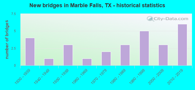
- New bridges - historical statistics
- 41930-1939
- 11940-1949
- 31950-1959
- 11960-1969
- 21970-1979
- 31980-1989
- 51990-1999
- 32000-2009
- 62010-2019

- Reconstructed bridges - Historical Statistics
- 21950-1959
- 11960-1969
- 01970-1979
- 31980-1989


- Bridge Condition - Deck
- 5.9%Very good
- 82.4%Good
- 11.8%Satisfactory

- Bridge Condition - Superstructure
- 17.6%Very good
- 52.9%Good
- 23.5%Satisfactory
- 5.9%Fair

- Bridge Condition - Substructure
- 52.9%Good
- 35.3%Satisfactory
- 11.8%Fair

- Bridge Condition - Channel
- 15.4%Very good
- 46.2%Good
- 34.6%Satisfactory
- 3.8%Fair

- Bridge Condition - Culverts
- 90.0%Good
- 10.0%Satisfactory
Find on map >> Show street view
Structure Number: 140270015005008, Location: 9.10 MI W OF US 281 (Lat: 30.756803, Lng: -98.375917), Route carried "on" structure: State highway 29, Year Built: 1937, Year Reconstructed: 1960, Status: Open, Structure Length: 5.27m (17.29ft), Average Daily Traffic: 6,018 (year 2020), Truck Traffic: 12%, Average Future Daily Traffic: 7,602 (year 2039), Design Load: H 15, Features Intersected: CLEAR CREEK
Minimum Vertical Clearance: 30+ m (98+ ft), Kilometerpoint: 2.543, Lanes on structure: 4, Owner: State Highway Agency, Approaching Roadway Width: 15.2m (49.9ft), Material/Design: Concrete, Design/Construction: Tee Beam, Number Of Spans In Main Unit: 5, Length of Maximum Span: 10.7m (35.1ft), Curb-To-Curb Width: 15.8m (51.8ft), Out-to-Out Width: 16.9m (55.4ft)
Condition: Deck: Good, Superstructure: Satisfactory, Substructure: Satisfactory, Channel: Satisfactory, Operating Rating: 67.1 metric tons, Method Used To Determine Operating Rating: Load Factor (LF), Inventory Rating: 39.9 metric tons, Method Used To Determine Inventory Rating: Load Factor (LF), Structural Evaluation: Equal to present minimum criteria, Deck Geometry: Meets minimum limits, Waterway Adequacy: Equal to present minimum criteria, Approach Roadway Alignment: Equal to present desirable criteria, Designated Inspection Frequency: Every 24 months, Inspection Date: April 2021, Deck Structure Type: Concrete Cast-file-Place, Wearing Surface/Protective System: Wearing Surface: Bituminous
Find on map >> Show street view
Structure Number: 140270025201005, Location: 0.65 MI N OF RM 1431 (Lat: 30.587678, Lng: -98.273347), Route carried "on" structure: US 281, Year Built: 1930, Year Reconstructed: 1980, Status: Open, Structure Length: 2.07m (6.79ft), Average Daily Traffic: 29,502 (year 2020), Truck Traffic: 19%, Average Future Daily Traffic: 34,630 (year 2033), Design Load: H 15, Features Intersected: WHITMAN BRANCH
Minimum Vertical Clearance: 30+ m (98+ ft), Kilometerpoint: 51.399, Lanes on structure: 5, Owner: State Highway Agency, Approaching Roadway Width: 18.3m (60.0ft), Skew: 4 degrees, Material/Design: Concrete, Design/Construction: Tee Beam, Number Of Spans In Main Unit: 3, Length of Maximum Span: 6.7m (22.0ft), Curb-To-Curb Width: 18.3m (60.0ft), Out-to-Out Width: 19.0m (62.3ft)
Condition: Deck: Good, Superstructure: Good, Substructure: Fair, Channel: Fair, Operating Rating: 37.2 metric tons, Method Used To Determine Operating Rating: Load Factor (LF), Inventory Rating: 22.7 metric tons, Method Used To Determine Inventory Rating: Load Factor (LF), Structural Evaluation: Somewhat better than minimum adequacy, Deck Geometry: High priority of replacement, Waterway Adequacy: Equal to present minimum criteria, Approach Roadway Alignment: Equal to present desirable criteria, Length Of Structure Improvement: 2.07m (6.79ft), Designated Inspection Frequency: Every 24 months, Inspection Date: June 2021, Deck Structure Type: Concrete Cast-file-Place, Wearing Surface/Protective System: Wearing Surface: Bituminous
Find on map >> Show street view
Structure Number: 140270025201006, Location: 0.10 MI N OF RM 1431 (Lat: 30.576886, Lng: -98.273089), Route carried "on" structure: US 281, Year Built: 1930, Year Reconstructed: 1956, Status: Open, Structure Length: 0.82m (2.69ft), Average Daily Traffic: 29,502 (year 2020), Truck Traffic: 19%, Average Future Daily Traffic: 37,220 (year 2033), Design Load: H 15, Features Intersected: DRAW
Minimum Vertical Clearance: 30+ m (98+ ft), Kilometerpoint: 52.616, Lanes on structure: 5, Owner: State Highway Agency, Approaching Roadway Width: 19.2m (63.0ft), Material/Design: Concrete, Design/Construction: Culvert, Number Of Spans In Main Unit: 3, Length of Maximum Span: 2.4m (7.9ft), Curb or Sidewalk Widths: Left: 1.6m (5.2ft), Right: 1.6m (5.2ft), Curb-To-Curb Width: 19.2m (63.0ft), Out-to-Out Width: 23.2m (76.1ft)
Condition: Channel: Satisfactory, Culverts: Good, Operating Rating: 39.9 metric tons, Method Used To Determine Operating Rating: Load Factor (LF), Inventory Rating: 23.6 metric tons, Method Used To Determine Inventory Rating: Load Factor (LF), Structural Evaluation: Somewhat better than minimum adequacy, Deck Geometry: Meets minimum limits, Waterway Adequacy: Equal to present minimum criteria, Approach Roadway Alignment: Equal to present desirable criteria, Length Of Structure Improvement: 0.82m (2.69ft), Designated Inspection Frequency: Every 24 months, Inspection Date: June 2021, Bridge Improvement Cost: $35,000, Roadway Improvement Cost: $9,000, Total Project Cost: $44,000, Deck Structure Type: Concrete Cast-file-Place, Wearing Surface/Protective System: Wearing Surface: Bituminous
Find on map >> Show street view
Structure Number: 140270025202008, Location: 1.80 MI N OF SH 71 (Lat: 30.532850, Lng: -98.282342), Route carried "on" structure: US 281, Year Built: 1930, Year Reconstructed: 1958, Status: Closed, Structure Length: 3.47m (11.38ft), Average Daily Traffic: 17,232 (year 2020), Truck Traffic: 19%, Average Future Daily Traffic: 19,710 (year 2033), Design Load: H 15, Features Intersected: LITTLE FLAT ROCK CREEK
Minimum Vertical Clearance: 30+ m (98+ ft), Kilometerpoint: 57.956, Lanes on structure: 4, Owner: State Highway Agency, Approaching Roadway Width: 13.4m (44.0ft), Material/Design: Concrete, Design/Construction: Tee Beam, Number Of Spans In Main Unit: 4, Length of Maximum Span: 8.5m (27.9ft), Curb-To-Curb Width: 16.2m (53.1ft), Out-to-Out Width: 16.8m (55.1ft)
Condition: Deck: Satisfactory, Superstructure: Fair, Substructure: Fair, Channel: Good, Deck Geometry: Meets minimum limits, Waterway Adequacy: Equal to present minimum criteria, Approach Roadway Alignment: Equal to present desirable criteria, Bridge Posting: Required (Relationship of Operating Rating to Maximum Legal Load: > 39.9% below), Designated Inspection Frequency: Every 24 months, Inspection Date: June 2021, Deck Structure Type: Concrete Cast-file-Place, Wearing Surface/Protective System: Wearing Surface: Bituminous
Find on map >> Show street view
Structure Number: 140270025202029, Location: 1.1 MI N OF BLANCO C/L (Lat: 30.509250, Lng: -98.296600), Route carried "on" structure: State highway 71, Year Built: 1971, Status: Open, Structure Length: 9.91m (32.51ft), Average Daily Traffic: 13,471 (year 2019), Truck Traffic: 6%, Average Future Daily Traffic: 16,973 (year 2039), Design Load: HS 20, Features Intersected: US 281
Minimum Vertical Clearance: 30+ m (98+ ft), Kilometerpoint: 5.182, Lanes on structure: 2, Lanes under structure: 6, Owner: State Highway Agency, Approaching Roadway Width: 14.6m (47.9ft), Skew: 1 degrees, Material/Design: Prestressed concrete, Design/Construction: Stringer/Multi-beam, Number Of Spans In Main Unit: 2, Number Of Approach Spans: 2, Length of Maximum Span: 30.5m (100.1ft), Curb-To-Curb Width: 14.6m (47.9ft), Out-to-Out Width: 15.3m (50.2ft)
Condition: Deck: Good, Superstructure: Good, Substructure: Good, Operating Rating: 68.9 metric tons, Method Used To Determine Operating Rating: Load Factor (LF), Inventory Rating: 34.5 metric tons, Method Used To Determine Inventory Rating: Load Factor (LF), Structural Evaluation: Better than present minimum criteria, Deck Geometry: Superior to present desirable criteria, Underclear: Equal to present minimum criteria, Approach Roadway Alignment: Equal to present desirable criteria, Designated Inspection Frequency: Every 24 months, Inspection Date: April 2021, Deck Structure Type: Concrete Cast-file-Place, Wearing Surface/Protective System: Wearing Surface: Bituminous
Find on map >> Show street view
Structure Number: 140270025202032, Location: 0.20 MI N OF RM 2147 (Lat: 30.565844, Lng: -98.274575), Route carried "on" structure: US 281, Year Built: 2012, Status: Open, Structure Length: 29.20m (95.80ft), Average Daily Traffic: 17,109 (year 2020), Truck Traffic: 9%, Average Future Daily Traffic: 41,580 (year 2031), Design Load: HL 93, Features Intersected: COLORADO RIVER
Minimum Vertical Clearance: 30+ m (98+ ft), Kilometerpoint: 53.797, Lanes on structure: 2, Owner: State Highway Agency, Approaching Roadway Width: 7.6m (24.9ft), Material/Design: Prestressed concrete continuous, Design/Construction: Segmental Box Girder, Number Of Spans In Main Unit: 1, Number Of Approach Spans: 2, Length of Maximum Span: 125.0m (410.1ft), Curb or Sidewalk Widths: Left: 0.0m, Right: 1.8m (5.9ft), Curb-To-Curb Width: 10.7m (35.1ft), Out-to-Out Width: 14.2m (46.6ft)
Condition: Deck: Good, Superstructure: Good, Substructure: Good, Channel: Very good, Operating Rating: 54.4 metric tons, Method Used To Determine Operating Rating: Assigned ratings based on Load and Resistance Factor Design (LRFD) reported in metric tons, Inventory Rating: 32.7 metric tons, Method Used To Determine Inventory Rating: Assigned ratings based on Load and Resistance Factor Design (LRFD) reported in metric tons, Structural Evaluation: Better than present minimum criteria, Deck Geometry: Somewhat better than minimum adequacy, Waterway Adequacy: Superior to present desirable criteria, Approach Roadway Alignment: Equal to present desirable criteria, Designated Inspection Frequency: Every 24 months, Underwater Inspection Frequency: Every 60 months, Inspection Date: June 2021, Underwater Inspection Date: May 2021, Deck Structure Type: Concrete Cast-file-Place
Find on map >> Show street view
Structure Number: 140270025202033, Location: 0.20 MI N OF RM 2147 (Lat: 30.568208, Lng: -98.275739), Route carried "on" structure: US 281, Year Built: 2014, Status: Open, Structure Length: 29.20m (95.80ft), Average Daily Traffic: 17,529 (year 2020), Truck Traffic: 9%, Average Future Daily Traffic: 41,580 (year 2031), Design Load: HL 93, Features Intersected: COLORADO RIVER
Minimum Vertical Clearance: 30+ m (98+ ft), Kilometerpoint: 53.797, Lanes on structure: 2, Owner: State Highway Agency, Approaching Roadway Width: 9.8m (32.2ft), Material/Design: Prestressed concrete continuous, Design/Construction: Segmental Box Girder, Number Of Spans In Main Unit: 1, Number Of Approach Spans: 2, Length of Maximum Span: 125.0m (410.1ft), Curb or Sidewalk Widths: Left: 1.8m (5.9ft), Right: 0.0m, Curb-To-Curb Width: 10.8m (35.4ft), Out-to-Out Width: 14.2m (46.6ft)
Condition: Deck: Good, Superstructure: Good, Substructure: Good, Channel: Very good, Operating Rating: 54.4 metric tons, Method Used To Determine Operating Rating: Assigned ratings based on Load and Resistance Factor Design (LRFD) reported in metric tons, Inventory Rating: 32.7 metric tons, Method Used To Determine Inventory Rating: Assigned ratings based on Load and Resistance Factor Design (LRFD) reported in metric tons, Structural Evaluation: Better than present minimum criteria, Deck Geometry: Somewhat better than minimum adequacy, Waterway Adequacy: Superior to present desirable criteria, Approach Roadway Alignment: Equal to present desirable criteria, Designated Inspection Frequency: Every 24 months, Underwater Inspection Frequency: Every 60 months, Inspection Date: June 2021, Underwater Inspection Date: May 2021, Deck Structure Type: Concrete Cast-file-Place
Find on map >> Show street view
Structure Number: 140270070001032, Location: 3.5 MI E OF US 281 (Lat: 30.493247, Lng: -98.241122), Route carried "on" structure: State highway 71, Year Built: 2005, Status: Open, Structure Length: 5.64m (18.50ft), Average Daily Traffic: 12,977 (year 2020), Truck Traffic: 3%, Average Future Daily Traffic: 16,973 (year 2039), Design Load: HS 20, Features Intersected: DOUBLE HORN CREEK
Minimum Vertical Clearance: 30+ m (98+ ft), Kilometerpoint: 10.898, Lanes on structure: 4, Owner: State Highway Agency, Approaching Roadway Width: 18.3m (60.0ft), Skew: 3 degrees, Material/Design: Prestressed concrete, Design/Construction: Stringer/Multi-beam, Number Of Spans In Main Unit: 4, Length of Maximum Span: 15.2m (49.9ft), Curb-To-Curb Width: 24.8m (81.4ft), Out-to-Out Width: 25.6m (84.0ft)
Condition: Deck: Good, Superstructure: Good, Substructure: Good, Channel: Good, Operating Rating: 54.4 metric tons, Method Used To Determine Operating Rating: Assigned rating based on Load Factor Design (LFD) reported in metric tons, Inventory Rating: 32.7 metric tons, Method Used To Determine Inventory Rating: Assigned rating based on Load Factor Design (LFD) reported in metric tons, Structural Evaluation: Better than present minimum criteria, Deck Geometry: Superior to present desirable criteria, Waterway Adequacy: Superior to present desirable criteria, Approach Roadway Alignment: Equal to present desirable criteria, Designated Inspection Frequency: Every 24 months, Inspection Date: April 2021, Deck Structure Type: Concrete Precast Panels, Wearing Surface/Protective System: Wearing Surface: Bituminous, Membrane: Built-up, Deck Protection: Epoxy Coated Reinforcing
Find on map >> Show street view
Structure Number: 140270070001033, Location: 0.75 MI E OF US 281 (Lat: 30.506139, Lng: -98.283822), Route carried "on" structure: State highway 71, Year Built: 2005, Status: Open, Structure Length: 4.88m (16.01ft), Average Daily Traffic: 12,977 (year 2020), Truck Traffic: 6%, Average Future Daily Traffic: 16,973 (year 2039), Design Load: HS 20, Features Intersected: FLAT ROCK CREEK
Minimum Vertical Clearance: 30+ m (98+ ft), Kilometerpoint: 6.405, Lanes on structure: 4, Owner: State Highway Agency, Approaching Roadway Width: 18.3m (60.0ft), Material/Design: Prestressed concrete, Design/Construction: Slab, Number Of Spans In Main Unit: 5, Length of Maximum Span: 10.7m (35.1ft), Curb-To-Curb Width: 24.8m (81.4ft), Out-to-Out Width: 25.6m (84.0ft)
Condition: Deck: Very good, Superstructure: Very good, Substructure: Good, Channel: Good, Operating Rating: 54.4 metric tons, Method Used To Determine Operating Rating: Assigned rating based on Load Factor Design (LFD) reported in metric tons, Inventory Rating: 32.7 metric tons, Method Used To Determine Inventory Rating: Assigned rating based on Load Factor Design (LFD) reported in metric tons, Structural Evaluation: Better than present minimum criteria, Deck Geometry: Superior to present desirable criteria, Waterway Adequacy: Equal to present minimum criteria, Approach Roadway Alignment: Equal to present desirable criteria, Designated Inspection Frequency: Every 24 months, Inspection Date: April 2021, Deck Structure Type: Concrete Cast-file-Place, Wearing Surface/Protective System: Wearing Surface: Bituminous
Find on map >> Show street view
Structure Number: 140270137803018, Location: 3.30 MI E OF US 281 (Lat: 30.581994, Lng: -98.227758), Route carried "on" structure: State highway 1431, Year Built: 1980, Status: Open, Structure Length: 6.40m (21.00ft), Average Daily Traffic: 8,955 (year 2020), Truck Traffic: 13%, Average Future Daily Traffic: 10,900 (year 2033), Design Load: HS 20, Features Intersected: HAMILTON CREEK
Minimum Vertical Clearance: 30+ m (98+ ft), Kilometerpoint: 5.193, Lanes on structure: 2, Owner: State Highway Agency, Approaching Roadway Width: 7.3m (24.0ft), Material/Design: Prestressed concrete, Design/Construction: Stringer/Multi-beam, Number Of Spans In Main Unit: 3, Length of Maximum Span: 21.3m (69.9ft), Curb-To-Curb Width: 12.2m (40.0ft), Out-to-Out Width: 12.9m (42.3ft)
Condition: Deck: Good, Superstructure: Good, Substructure: Good, Channel: Satisfactory, Operating Rating: 68.0 metric tons, Method Used To Determine Operating Rating: Load Factor (LF), Inventory Rating: 35.4 metric tons, Method Used To Determine Inventory Rating: Load Factor (LF), Structural Evaluation: Better than present minimum criteria, Deck Geometry: Somewhat better than minimum adequacy, Waterway Adequacy: Equal to present minimum criteria, Approach Roadway Alignment: Equal to present desirable criteria, Designated Inspection Frequency: Every 24 months, Inspection Date: June 2021, Deck Structure Type: Concrete Precast Panels, Wearing Surface/Protective System: Wearing Surface: Bituminous
Find on map >> Show street view
Structure Number: 140270137803029, Location: 5.15 MI E OF US 281 (Lat: 30.588311, Lng: -98.197481), Route carried "on" structure: State highway 1431, Year Built: 1991, Status: Open, Structure Length: 4.88m (16.01ft), Average Daily Traffic: 2,190 (year 2013), Truck Traffic: 13%, Average Future Daily Traffic: 3,070 (year 2033), Design Load: HS 20, Features Intersected: SYCAMORE CREEK
Minimum Vertical Clearance: 30+ m (98+ ft), Kilometerpoint: 8.291, Lanes on structure: 2, Owner: State Highway Agency, Approaching Roadway Width: 7.3m (24.0ft), Skew: 2 degrees, Material/Design: Concrete, Design/Construction: Stringer/Multi-beam, Number Of Spans In Main Unit: 5, Length of Maximum Span: 9.8m (32.2ft), Curb-To-Curb Width: 12.3m (40.4ft), Out-to-Out Width: 13.0m (42.7ft)
Condition: Deck: Good, Superstructure: Good, Substructure: Satisfactory, Channel: Satisfactory, Operating Rating: 50.8 metric tons, Method Used To Determine Operating Rating: Load Factor (LF), Inventory Rating: 29.9 metric tons, Method Used To Determine Inventory Rating: Load Factor (LF), Structural Evaluation: Equal to present minimum criteria, Deck Geometry: Equal to present minimum criteria, Waterway Adequacy: Equal to present minimum criteria, Approach Roadway Alignment: Equal to present desirable criteria, Designated Inspection Frequency: Every 24 months, Inspection Date: June 2021, Deck Structure Type: Concrete Cast-file-Place, Wearing Surface/Protective System: Wearing Surface: Bituminous
Find on map >> Show street view
Structure Number: 140270137804008, Location: 0.30 MI W OF US 281 (Lat: 30.580750, Lng: -98.277806), Route carried "on" structure: State highway 1431, Year Built: 1958, Year Reconstructed: 1986, Status: Open, Structure Length: 2.74m (8.99ft), Average Daily Traffic: 15,854 (year 2020), Truck Traffic: 5%, Average Future Daily Traffic: 21,850 (year 2033), Features Intersected: WHITMAN DRAW
Minimum Vertical Clearance: 30+ m (98+ ft), Kilometerpoint: 18.348, Lanes on structure: 5, Owner: State Highway Agency, Approaching Roadway Width: 18.3m (60.0ft), Material/Design: Concrete, Design/Construction: Stringer/Multi-beam, Number Of Spans In Main Unit: 3, Length of Maximum Span: 9.1m (29.9ft), Curb or Sidewalk Widths: Left: 1.1m (3.6ft), Right: 1.1m (3.6ft), Curb-To-Curb Width: 18.3m (60.0ft), Out-to-Out Width: 21.3m (69.9ft)
Condition: Deck: Good, Superstructure: Satisfactory, Substructure: Satisfactory, Channel: Satisfactory, Operating Rating: 50.8 metric tons, Method Used To Determine Operating Rating: Load Factor (LF), Inventory Rating: 29.0 metric tons, Method Used To Determine Inventory Rating: Load Factor (LF), Structural Evaluation: Equal to present minimum criteria, Deck Geometry: High priority of replacement, Waterway Adequacy: Equal to present minimum criteria, Approach Roadway Alignment: Equal to present desirable criteria, Length Of Structure Improvement: 2.74m (8.99ft), Designated Inspection Frequency: Every 24 months, Inspection Date: May 2021, Deck Structure Type: Concrete Cast-file-Place, Wearing Surface/Protective System: Wearing Surface: Bituminous
Find on map >> Show street view
Structure Number: 140270137804014, Location: 0.80 MI W OF US 281 (Lat: 30.584014, Lng: -98.284475), Route carried "on" structure: State highway 1431, Year Built: 1964, Year Reconstructed: 1986, Status: Open, Structure Length: 6.10m (20.01ft), Average Daily Traffic: 15,854 (year 2020), Truck Traffic: 5%, Average Future Daily Traffic: 21,850 (year 2033), Design Load: H 20, Features Intersected: BACKBONE CREEK
Minimum Vertical Clearance: 30+ m (98+ ft), Kilometerpoint: 17.601, Lanes on structure: 5, Owner: State Highway Agency, Approaching Roadway Width: 18.3m (60.0ft), Material/Design: Concrete, Design/Construction: Stringer/Multi-beam, Number Of Spans In Main Unit: 5, Length of Maximum Span: 12.2m (40.0ft), Curb or Sidewalk Widths: Left: 1.2m (3.9ft), Right: 1.2m (3.9ft), Curb-To-Curb Width: 18.3m (60.0ft), Out-to-Out Width: 21.3m (69.9ft)
Condition: Deck: Good, Superstructure: Good, Substructure: Satisfactory, Channel: Good, Operating Rating: 44.4 metric tons, Method Used To Determine Operating Rating: Load Factor (LF), Inventory Rating: 27.2 metric tons, Method Used To Determine Inventory Rating: Load Factor (LF), Structural Evaluation: Equal to present minimum criteria, Deck Geometry: High priority of replacement, Waterway Adequacy: Equal to present minimum criteria, Approach Roadway Alignment: Equal to present desirable criteria, Designated Inspection Frequency: Every 24 months, Inspection Date: May 2021, Deck Structure Type: Concrete Cast-file-Place, Wearing Surface/Protective System: Wearing Surface: Bituminous
Find on map >> Show street view
Structure Number: 140270341301001, Location: 0.65 MI N OF RM 1431 (Lat: 30.602797, Lng: -98.303306), Route carried "on" structure: State highway 1980, Year Built: 1982, Status: Open, Structure Length: 1.01m (3.31ft), Average Daily Traffic: 3,631 (year 2020), Truck Traffic: 8%, Average Future Daily Traffic: 4,190 (year 2033), Design Load: HS 20, Features Intersected: DRY BRANCH
Minimum Vertical Clearance: 30+ m (98+ ft), Kilometerpoint: 6.537, Lanes on structure: 2, Owner: State Highway Agency, Approaching Roadway Width: 12.2m (40.0ft), Material/Design: Concrete, Design/Construction: Culvert, Number Of Spans In Main Unit: 3, Length of Maximum Span: 3.0m (9.8ft), Curb-To-Curb Width: 13.7m (44.9ft), Out-to-Out Width: 15.6m (51.2ft)
Condition: Channel: Good, Culverts: Good, Operating Rating: 39.9 metric tons, Method Used To Determine Operating Rating: Load Factor (LF), Inventory Rating: 23.6 metric tons, Method Used To Determine Inventory Rating: Load Factor (LF), Structural Evaluation: Equal to present minimum criteria, Deck Geometry: Superior to present desirable criteria, Waterway Adequacy: Better than present minimum criteria, Approach Roadway Alignment: Equal to present desirable criteria, Designated Inspection Frequency: Every 48 months, Inspection Date: May 2021, Deck Structure Type: Concrete Cast-file-Place, Wearing Surface/Protective System: Wearing Surface: Bituminous
Find on map >> Show street view
Structure Number: 140270AA0404001, Location: 1.65 MI SOUTH OF FM 2147 (Lat: 30.529711, Lng: -98.213775), Route carried "on" structure: County highway 404, Year Built: 2012, Status: Open, Structure Length: 1.52m (4.99ft), Average Daily Traffic: 114 (year 2016), Average Future Daily Traffic: 228 (year 2036), Design Load: HL 93, Features Intersected: GRIDIRON BRANCH
Minimum Vertical Clearance: 30+ m (98+ ft), Kilometerpoint: 0.000, Lanes on structure: 2, Owner: County Highway Agency, Approaching Roadway Width: 6.1m (20.0ft), Material/Design: Prestressed concrete, Design/Construction: Stringer/Multi-beam, Number Of Spans In Main Unit: 1, Length of Maximum Span: 14.6m (47.9ft), Curb-To-Curb Width: 8.5m (27.9ft), Out-to-Out Width: 9.1m (29.9ft)
Condition: Deck: Good, Superstructure: Very good, Substructure: Good, Channel: Good, Operating Rating: 54.4 metric tons, Method Used To Determine Operating Rating: Assigned ratings based on Load and Resistance Factor Design (LRFD) reported in metric tons, Inventory Rating: 32.7 metric tons, Method Used To Determine Inventory Rating: Assigned ratings based on Load and Resistance Factor Design (LRFD) reported in metric tons, Structural Evaluation: Better than present minimum criteria, Deck Geometry: Equal to present minimum criteria, Waterway Adequacy: Better than present minimum criteria, Approach Roadway Alignment: Equal to present minimum criteria, Designated Inspection Frequency: Every 24 months, Inspection Date: January 2020, Deck Structure Type: Concrete Precast Panels
Find on map >> Show street view
Structure Number: 140270AA0463001, Location: 4.0 MI NE OF MARBLE FALL (Lat: 30.622375, Lng: -98.230033), Route carried "on" structure: County highway 341, Year Built: 1941, Status: Open, Structure Length: 2.96m (9.71ft), Average Daily Traffic: 80 (year 2011), Average Future Daily Traffic: 150 (year 2031), Features Intersected: HAMILTON CREEK
Minimum Vertical Clearance: 30+ m (98+ ft), Kilometerpoint: 0.241, Lanes on structure: 2, Owner: County Highway Agency, Approaching Roadway Width: 4.9m (16.1ft), Material/Design: Concrete, Design/Construction: Slab, Number Of Spans In Main Unit: 8, Length of Maximum Span: 3.7m (12.1ft), Curb-To-Curb Width: 5.7m (18.7ft), Out-to-Out Width: 6.1m (20.0ft)
Condition: Deck: Satisfactory, Superstructure: Satisfactory, Substructure: Satisfactory, Channel: Satisfactory, Operating Rating: 32.7 metric tons, Method Used To Determine Operating Rating: Field evaluation and documented engineering judgment, Inventory Rating: 24.5 metric tons, Method Used To Determine Inventory Rating: Field evaluation and documented engineering judgment, Structural Evaluation: Equal to present minimum criteria, Deck Geometry: Meets minimum limits, Waterway Adequacy: Meets minimum limits, Approach Roadway Alignment: High priority of corrective action, Length Of Structure Improvement: 2.99m (9.81ft), Designated Inspection Frequency: Every 24 months, Inspection Date: January 2020, Bridge Improvement Cost: $42,000, Roadway Improvement Cost: $12,000, Total Project Cost: $54,000, Deck Structure Type: Concrete Cast-file-Place
Find on map >> Show street view
Structure Number: 140270AA0540001, Location: 1.0 MI E OF US 281 (Lat: 30.553022, Lng: -98.260097), Route carried "on" structure: County highway 540, Year Built: 1952, Status: Open, Structure Length: 5.03m (16.50ft), Average Daily Traffic: 160 (year 2011), Average Future Daily Traffic: 300 (year 2031), Features Intersected: FLATHEAD CREEK, Facility Carried by Structure: MAX STARKE RD
Minimum Vertical Clearance: 30+ m (98+ ft), Kilometerpoint: 1.690, Lanes on structure: 2, Owner: County Highway Agency, Approaching Roadway Width: 5.5m (18.0ft), Skew: 4 degrees, Material/Design: Steel continuous, Design/Construction: Stringer/Multi-beam, Number Of Spans In Main Unit: 8, Length of Maximum Span: 6.1m (20.0ft), Curb-To-Curb Width: 6.2m (20.3ft), Out-to-Out Width: 6.7m (22.0ft)
Condition: Deck: Good, Superstructure: Satisfactory, Substructure: Satisfactory, Channel: Good, Operating Rating: 68.0 metric tons, Method Used To Determine Operating Rating: Allowable Stress (AS), Inventory Rating: 40.8 metric tons, Method Used To Determine Inventory Rating: Allowable Stress (AS), Structural Evaluation: Equal to present minimum criteria, Deck Geometry: Meets minimum limits, Waterway Adequacy: Equal to present desirable criteria, Approach Roadway Alignment: Somewhat better than minimum adequacy, Length Of Structure Improvement: 4.88m (16.01ft), Designated Inspection Frequency: Every 24 months, Inspection Date: January 2020, Total Project Cost: $249,000, Deck Structure Type: Concrete Cast-file-Place
Find on map >> Show street view
Structure Number: 140270C00010001, Location: 0.20 MI NW OF US 281 (Lat: 30.572028, Lng: -98.280031), Route carried "on" structure: City street , Year Built: 1997, Status: Open, Structure Length: 1.34m (4.40ft), Average Daily Traffic: 1,000 (year 2011), Average Future Daily Traffic: 2,000 (year 2031), Features Intersected: WHITMAN BRANCH, Facility Carried by Structure: 2ND ST
Minimum Vertical Clearance: 30+ m (98+ ft), Kilometerpoint: 0.322, Lanes on structure: 2, Owner: Town or Township Highway Agency, Approaching Roadway Width: 9.1m (29.9ft), Material/Design: Concrete, Design/Construction: Culvert, Number Of Spans In Main Unit: 5, Length of Maximum Span: 2.4m (7.9ft), Curb or Sidewalk Widths: Left: 2.3m (7.5ft), Right: 1.1m (3.6ft), Curb-To-Curb Width: 9.1m (29.9ft), Out-to-Out Width: 13.4m (44.0ft)
Condition: Channel: Good, Culverts: Good, Operating Rating: 32.7 metric tons, Method Used To Determine Operating Rating: Field evaluation and documented engineering judgment, Inventory Rating: 24.5 metric tons, Method Used To Determine Inventory Rating: Field evaluation and documented engineering judgment, Structural Evaluation: Equal to present minimum criteria, Deck Geometry: Equal to present minimum criteria, Waterway Adequacy: Better than present minimum criteria, Approach Roadway Alignment: Equal to present desirable criteria, Designated Inspection Frequency: Every 24 months, Inspection Date: January 2020, Deck Structure Type: Concrete Cast-file-Place, Wearing Surface/Protective System: Wearing Surface: Bituminous
Find on map >> Show street view
Structure Number: 140270C00015501, Location: 0.25 MI W OF US 281 (Lat: 30.573125, Lng: -98.279783), Route carried "on" structure: City street , Year Built: 2010, Status: Open, Structure Length: 1.80m (5.91ft), Average Daily Traffic: 670 (year 2011), Average Future Daily Traffic: 1,200 (year 2031), Design Load: HS 20, Features Intersected: WHITMAN BRANCH, Facility Carried by Structure: THIRD ST
Minimum Vertical Clearance: 30+ m (98+ ft), Kilometerpoint: 0.402, Lanes on structure: 2, Owner: Town or Township Highway Agency, Approaching Roadway Width: 8.5m (27.9ft), Skew: 1 degrees, Material/Design: Concrete, Design/Construction: Culvert, Number Of Spans In Main Unit: 4, Length of Maximum Span: 3.7m (12.1ft), Curb or Sidewalk Widths: Left: 1.6m (5.2ft), Right: 1.6m (5.2ft), Curb-To-Curb Width: 8.5m (27.9ft), Out-to-Out Width: 12.5m (41.0ft)
Condition: Channel: Good, Culverts: Good, Operating Rating: 54.4 metric tons, Method Used To Determine Operating Rating: Assigned rating based on Load Factor Design (LFD) reported in metric tons, Inventory Rating: 32.7 metric tons, Method Used To Determine Inventory Rating: Assigned rating based on Load Factor Design (LFD) reported in metric tons, Structural Evaluation: Better than present minimum criteria, Deck Geometry: Somewhat better than minimum adequacy, Waterway Adequacy: Better than present minimum criteria, Approach Roadway Alignment: Equal to present desirable criteria, Designated Inspection Frequency: Every 24 months, Inspection Date: January 2020, Deck Structure Type: Concrete Cast-file-Place, Wearing Surface/Protective System: Wearing Surface: Bituminous
Find on map >> Show street view
Structure Number: 140270C00020001, Location: 0.00 MI S OF AVE L (Lat: 30.574417, Lng: -98.279900), Route carried "on" structure: City street , Year Built: 1994, Status: Open, Structure Length: 1.55m (5.09ft), Average Daily Traffic: 300 (year 2011), Truck Traffic: 2%, Average Future Daily Traffic: 500 (year 2031), Features Intersected: WHITMAN DRAW, Facility Carried by Structure: FOURTH ST
Minimum Vertical Clearance: 30+ m (98+ ft), Kilometerpoint: 0.322, Lanes on structure: 2, Owner: Town or Township Highway Agency, Approaching Roadway Width: 8.5m (27.9ft), Skew: 3 degrees, Material/Design: Concrete, Design/Construction: Culvert, Number Of Spans In Main Unit: 5, Length of Maximum Span: 2.4m (7.9ft), Curb or Sidewalk Widths: Left: 2.0m (6.6ft), Right: 2.1m (6.9ft), Curb-To-Curb Width: 9.3m (30.5ft), Out-to-Out Width: 14.2m (46.6ft)
Condition: Channel: Satisfactory, Culverts: Good, Operating Rating: 32.7 metric tons, Method Used To Determine Operating Rating: Field evaluation and documented engineering judgment, Inventory Rating: 24.5 metric tons, Method Used To Determine Inventory Rating: Field evaluation and documented engineering judgment, Structural Evaluation: Equal to present minimum criteria, Deck Geometry: Equal to present minimum criteria, Waterway Adequacy: Equal to present desirable criteria, Approach Roadway Alignment: Equal to present desirable criteria, Designated Inspection Frequency: Every 24 months, Inspection Date: January 2020, Deck Structure Type: Concrete Cast-file-Place, Wearing Surface/Protective System: Wearing Surface: Bituminous
Find on map >> Show street view
Structure Number: 140270C00050001, Location: 0.15 MI E OF US 281 (Lat: 30.579336, Lng: -98.270108), Route carried "on" structure: City street , Year Built: 1997, Status: Open, Structure Length: 1.22m (4.00ft), Average Daily Traffic: 400 (year 2016), Average Future Daily Traffic: 800 (year 2036), Features Intersected: DRAW, Facility Carried by Structure: 12TH ST
Minimum Vertical Clearance: 30+ m (98+ ft), Kilometerpoint: 0.241, Lanes on structure: 2, Owner: Town or Township Highway Agency, Approaching Roadway Width: 8.5m (27.9ft), Skew: 3 degrees, Material/Design: Concrete, Design/Construction: Culvert, Number Of Spans In Main Unit: 4, Length of Maximum Span: 2.4m (7.9ft), Curb or Sidewalk Widths: Left: 1.7m (5.6ft), Right: 1.7m (5.6ft), Curb-To-Curb Width: 9.4m (30.8ft), Out-to-Out Width: 13.7m (44.9ft)
Condition: Channel: Good, Culverts: Good, Operating Rating: 32.7 metric tons, Method Used To Determine Operating Rating: Field evaluation and documented engineering judgment, Inventory Rating: 24.5 metric tons, Method Used To Determine Inventory Rating: Field evaluation and documented engineering judgment, Structural Evaluation: Equal to present minimum criteria, Deck Geometry: Equal to present minimum criteria, Waterway Adequacy: Meets minimum limits, Approach Roadway Alignment: Equal to present desirable criteria, Designated Inspection Frequency: Every 24 months, Inspection Date: January 2020, Deck Structure Type: Concrete Cast-file-Place, Wearing Surface/Protective System: Wearing Surface: Bituminous
Find on map >> Show street view
Structure Number: 140270C00140001, Location: 0.80 MI S OF FM 1431 (Lat: 30.568608, Lng: -98.280881), Route carried "on" structure: City street , Year Built: 1958, Status: Open, Structure Length: 1.01m (3.31ft), Average Daily Traffic: 400 (year 2011), Average Future Daily Traffic: 710 (year 2031), Features Intersected: BACKBONE CREEK, Facility Carried by Structure: AVE J
Minimum Vertical Clearance: 30+ m (98+ ft), Kilometerpoint: 1.127, Lanes on structure: 2, Owner: County Highway Agency, Approaching Roadway Width: 9.1m (29.9ft), Material/Design: Concrete, Design/Construction: Culvert, Number Of Spans In Main Unit: 3, Length of Maximum Span: 3.0m (9.8ft), Curb or Sidewalk Widths: Left: 2.0m (6.6ft), Right: 0.0m, Curb-To-Curb Width: 9.7m (31.8ft), Out-to-Out Width: 12.8m (42.0ft)
Condition: Channel: Good, Culverts: Satisfactory, Operating Rating: 32.7 metric tons, Method Used To Determine Operating Rating: Field evaluation and documented engineering judgment, Inventory Rating: 24.5 metric tons, Method Used To Determine Inventory Rating: Field evaluation and documented engineering judgment, Structural Evaluation: Equal to present minimum criteria, Deck Geometry: Equal to present minimum criteria, Waterway Adequacy: Equal to present desirable criteria, Approach Roadway Alignment: Equal to present desirable criteria, Length Of Structure Improvement: 1.01m (3.31ft), Designated Inspection Frequency: Every 24 months, Inspection Date: January 2020, Total Project Cost: $625,000, Deck Structure Type: Concrete Cast-file-Place
Find on map >> Show street view
Structure Number: 140270C00145001, Location: 0.8 MI S OF FM 1431 (Lat: 30.571117, Lng: -98.285283), Route carried "on" structure: City street , Year Built: 1985, Status: Open, Structure Length: 0.91m (2.99ft), Average Daily Traffic: 500 (year 2016), Average Future Daily Traffic: 1,000 (year 2036), Features Intersected: BACKBONE CREEK, Facility Carried by Structure: AVE N
Minimum Vertical Clearance: 30+ m (98+ ft), Kilometerpoint: 1.287, Lanes on structure: 2, Owner: Town or Township Highway Agency, Approaching Roadway Width: 7.9m (25.9ft), Skew: 3 degrees, Material/Design: Concrete, Design/Construction: Culvert, Number Of Spans In Main Unit: 3, Length of Maximum Span: 2.4m (7.9ft), Curb-To-Curb Width: 8.2m (26.9ft), Out-to-Out Width: 8.5m (27.9ft)
Condition: Channel: Satisfactory, Culverts: Good, Operating Rating: 32.7 metric tons, Method Used To Determine Operating Rating: Field evaluation and documented engineering judgment, Inventory Rating: 24.5 metric tons, Method Used To Determine Inventory Rating: Field evaluation and documented engineering judgment, Structural Evaluation: Equal to present minimum criteria, Deck Geometry: Somewhat better than minimum adequacy, Waterway Adequacy: High priority of corrective action, Approach Roadway Alignment: Equal to present desirable criteria, Designated Inspection Frequency: Every 24 months, Inspection Date: January 2020, Deck Structure Type: Concrete Cast-file-Place
Find on map >> Show street view
Structure Number: 140270C00225001, Location: 0.05 MI SE OF AVE S (Lat: 30.581736, Lng: -98.284831), Route carried "on" structure: City street , Year Built: 1991, Status: Open, Structure Length: 4.63m (15.19ft), Average Daily Traffic: 2,220 (year 2020), Average Future Daily Traffic: 400 (year 2031), Design Load: HS 20, Features Intersected: BACKBONE CREEK, Facility Carried by Structure: BROADWAY ST
Minimum Vertical Clearance: 30+ m (98+ ft), Kilometerpoint: 0.483, Lanes on structure: 2, Owner: County Highway Agency, Approaching Roadway Width: 7.9m (25.9ft), Skew: 3 degrees, Material/Design: Concrete continuous, Design/Construction: Slab, Number Of Spans In Main Unit: 6, Length of Maximum Span: 7.6m (24.9ft), Curb or Sidewalk Widths: Left: 1.2m (3.9ft), Right: 0.0m, Curb-To-Curb Width: 7.8m (25.6ft), Out-to-Out Width: 10.1m (33.1ft)
Condition: Deck: Good, Superstructure: Good, Substructure: Good, Channel: Satisfactory, Operating Rating: 54.4 metric tons, Method Used To Determine Operating Rating: Assigned rating based on Load Factor Design (LFD) reported in metric tons, Inventory Rating: 32.7 metric tons, Method Used To Determine Inventory Rating: Assigned rating based on Load Factor Design (LFD) reported in metric tons, Structural Evaluation: Better than present minimum criteria, Deck Geometry: High priority of replacement, Waterway Adequacy: Meets minimum limits, Approach Roadway Alignment: Equal to present desirable criteria, Designated Inspection Frequency: Every 24 months, Inspection Date: January 2020, Deck Structure Type: Concrete Cast-file-Place, Wearing Surface/Protective System: Wearing Surface: Bituminous
Find on map >> Show street view
Structure Number: 140270C00300001, Location: 0.7 MI S OF 2ND ST (Lat: 30.563003, Lng: -98.286197), Route carried "on" structure: City street , Year Built: 2007, Status: Open, Structure Length: 4.27m (14.01ft), Average Daily Traffic: 400 (year 2016), Average Future Daily Traffic: 800 (year 2036), Design Load: HL 93, Features Intersected: DRAW, Facility Carried by Structure: PECAN VALLEY DR
Minimum Vertical Clearance: 30+ m (98+ ft), Kilometerpoint: 1.127, Lanes on structure: 2, Owner: Town or Township Highway Agency, Approaching Roadway Width: 6.7m (22.0ft), Skew: 1 degrees, Material/Design: Prestressed concrete, Design/Construction: Stringer/Multi-beam, Number Of Spans In Main Unit: 2, Length of Maximum Span: 21.3m (69.9ft), Curb or Sidewalk Widths: Left: 0.0m, Right: 1.8m (5.9ft), Curb-To-Curb Width: 9.1m (29.9ft), Out-to-Out Width: 12.2m (40.0ft)
Condition: Deck: Good, Superstructure: Very good, Substructure: Good, Channel: Good, Operating Rating: 54.4 metric tons, Method Used To Determine Operating Rating: Assigned ratings based on Load and Resistance Factor Design (LRFD) reported in metric tons, Inventory Rating: 32.7 metric tons, Method Used To Determine Inventory Rating: Assigned ratings based on Load and Resistance Factor Design (LRFD) reported in metric tons, Structural Evaluation: Better than present minimum criteria, Deck Geometry: Equal to present minimum criteria, Waterway Adequacy: Superior to present desirable criteria, Approach Roadway Alignment: Equal to present desirable criteria, Designated Inspection Frequency: Every 24 months, Inspection Date: January 2020, Deck Structure Type: Concrete Precast Panels
Find on map >> Show street view
Structure Number: 140270C00340001, Location: 1.95 MI NE OF US 281 (Lat: 30.601581, Lng: -98.252236), Route carried "on" structure: County highway 340, Year Built: 2010, Status: Open, Structure Length: 0.91m (2.99ft), Average Daily Traffic: 200 (year 2011), Average Future Daily Traffic: 300 (year 2031), Design Load: HL 93, Features Intersected: DRAW
Minimum Vertical Clearance: 30+ m (98+ ft), Kilometerpoint: 3.138, Lanes on structure: 2, Owner: Town or Township Highway Agency, Approaching Roadway Width: 13.4m (44.0ft), Material/Design: Concrete, Design/Construction: Culvert, Number Of Spans In Main Unit: 4, Length of Maximum Span: 1.8m (5.9ft), Curb or Sidewalk Widths: Left: 0.0m, Right: 1.7m (5.6ft), Curb-To-Curb Width: 13.4m (44.0ft), Out-to-Out Width: 18.0m (59.1ft)
Condition: Channel: Very good, Culverts: Good, Operating Rating: 54.4 metric tons, Method Used To Determine Operating Rating: Assigned ratings based on Load and Resistance Factor Design (LRFD) reported in metric tons, Inventory Rating: 32.7 metric tons, Method Used To Determine Inventory Rating: Assigned ratings based on Load and Resistance Factor Design (LRFD) reported in metric tons, Structural Evaluation: Better than present minimum criteria, Deck Geometry: Superior to present desirable criteria, Waterway Adequacy: Better than present minimum criteria, Approach Roadway Alignment: Equal to present desirable criteria, Designated Inspection Frequency: Every 24 months, Inspection Date: January 2020, Deck Structure Type: Concrete Cast-file-Place, Wearing Surface/Protective System: Wearing Surface: Bituminous
Find on map >> Show street view
Structure Number: 140270C00340002, Location: 2.0 MI NE OF US 281 (Lat: 30.602142, Lng: -98.251542), Route carried "on" structure: County highway 340, Year Built: 2010, Status: Open, Structure Length: 0.88m (2.89ft), Average Daily Traffic: 200 (year 2011), Average Future Daily Traffic: 300 (year 2031), Features Intersected: DRAW
Minimum Vertical Clearance: 30+ m (98+ ft), Kilometerpoint: 3.219, Lanes on structure: 2, Owner: Town or Township Highway Agency, Approaching Roadway Width: 13.4m (44.0ft), Material/Design: Concrete, Design/Construction: Culvert, Number Of Spans In Main Unit: 3, Length of Maximum Span: 2.4m (7.9ft), Curb or Sidewalk Widths: Left: 0.0m, Right: 1.7m (5.6ft), Curb-To-Curb Width: 13.4m (44.0ft), Out-to-Out Width: 17.9m (58.7ft)
Condition: Channel: Very good, Culverts: Good, Operating Rating: 32.7 metric tons, Method Used To Determine Operating Rating: Field evaluation and documented engineering judgment, Inventory Rating: 24.5 metric tons, Method Used To Determine Inventory Rating: Field evaluation and documented engineering judgment, Structural Evaluation: Equal to present minimum criteria, Deck Geometry: Superior to present desirable criteria, Waterway Adequacy: Better than present minimum criteria, Approach Roadway Alignment: Equal to present desirable criteria, Designated Inspection Frequency: Every 24 months, Inspection Date: January 2020, Deck Structure Type: Concrete Cast-file-Place, Wearing Surface/Protective System: Wearing Surface: Bituminous
Find on map >> Show street view
Structure Number: 140270025202029, Location: 1.1 MI N OF BLANCO C/L (Lat: 30.509250, Lng: -98.296600), Route carried "under" structure: US 281, Year Built: 1971, Structure Length: 0. m, Average Daily Traffic: 10,826 (year 2019), Truck Traffic: 19%, Features Intersected: US 281, Facility Carried by Structure: SH 71
Minimum Vertical Clearance: 5.54m (18.18ft), Kilometerpoint: 60.914, Lanes on structure: 2, Lanes under structure: 6, Material/Design: Prestressed concrete, Design/Construction: Stringer/Multi-beam, Length of Maximum Span: 30.5m (100.1ft)