Bridge Statistics for Manchester, Virginia (VA)
Condition, Traffic, Stress, Structural Evaluation, Project Costs
- National Bridge Inventory (NBI) Statistics
- 20Number of bridges
- 125ft / 37.8mTotal length
- $306,000Total costs
- 585,714Total average daily traffic
- 16,058Total average daily truck traffic
- National Bridge Inventory (NBI) Registered Bridges for Manchester
- No street view available for this location
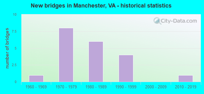
- New bridges - historical statistics
- 11960-1969
- 81970-1979
- 61980-1989
- 41990-1999
- 12010-2019


- Bridge Condition - Deck
- 62.5%Good
- 37.5%Satisfactory

- Bridge Condition - Superstructure
- 37.5%Good
- 62.5%Satisfactory

- Bridge Condition - Substructure
- 25.0%Good
- 75.0%Satisfactory

- Bridge Condition - Channel
- 16.7%Satisfactory
- 66.7%Fair
- 16.7%Poor

- Bridge Condition - Culverts
- 80.0%Satisfactory
- 20.0%Fair
Find on map >> Show street view
Structure Number: 5032, Location: 2.24 Fr 653 & 0.61 To 60 (Lat: 37.487825, Lng: -77.567203), Route carried "on" structure: State highway 76, Year Built: 1988, Status: Open, Structure Length: 3.05m (10.01ft), Average Daily Traffic: 41,820 (year 2020), Truck Traffic: 1%, Average Future Daily Traffic: 49,425 (year 2040), Design Load: HS 20+Mod, Features Intersected: RTE 2510 (REDBRIDGE ROAD
Minimum Vertical Clearance: 30+ m (98+ ft), Kilometerpoint: 9.670, Lanes on structure: 4, Lanes under structure: 2, Base Highway Network: Yes, Toll: On toll road, Owner: State Highway Agency, Approaching Roadway Width: 22.9m (75.1ft), Skew: 30 degrees, Material/Design: Steel, Design/Construction: Stringer/Multi-beam, Number Of Spans In Main Unit: 1, Length of Maximum Span: 29.5m (96.8ft), Curb-To-Curb Width: 23.3m (76.4ft), Out-to-Out Width: 24.3m (79.7ft)
Condition: Deck: Good, Superstructure: Good, Substructure: Satisfactory, Operating Rating: 77.1 metric tons, Method Used To Determine Operating Rating: Load and Resistance Factor (LRFR), Inventory Rating: 59.0 metric tons, Method Used To Determine Inventory Rating: Load and Resistance Factor (LRFR), Structural Evaluation: Equal to present minimum criteria, Deck Geometry: Superior to present desirable criteria, Underclear: Meets minimum limits, Approach Roadway Alignment: Equal to present desirable criteria, Designated Inspection Frequency: Every 24 months, Inspection Date: July 2020, Deck Structure Type: Concrete Cast-file-Place, Wearing Surface/Protective System: Deck Protection: Epoxy Coated Reinforcing
Find on map >> Show street view
Structure Number: 5115, Location: 0.74 Fr 60 & 0.61 To 360 (Lat: 37.488906, Lng: -77.519789), Route carried "on" structure: State highway 150, Year Built: 1968, Status: Open, Structure Length: 1.28m (4.20ft), Average Daily Traffic: 68,600 (year 2020), Truck Traffic: 2%, Average Future Daily Traffic: 96,040 (year 2040), Design Load: H 20, Features Intersected: POCOSHAM CREEK, Facility Carried by Structure: CHIPPENHAM PARKWAY
Minimum Vertical Clearance: 30+ m (98+ ft), Kilometerpoint: 12.277, Lanes on structure: 4, Base Highway Network: Yes, Owner: State Highway Agency, Approaching Roadway Width: 24.4m (80.1ft), Skew: 24 degrees, Material/Design: Concrete, Design/Construction: Culvert, Number Of Spans In Main Unit: 1, Number Of Approach Spans: 2, Length of Maximum Span: 4.3m (14.1ft)
Condition: Channel: Fair, Culverts: Fair, Operating Rating: 54.4 metric tons, Method Used To Determine Operating Rating: Load Factor (LF), Inventory Rating: 32.7 metric tons, Method Used To Determine Inventory Rating: Load Factor (LF), Structural Evaluation: Somewhat better than minimum adequacy, Waterway Adequacy: Equal to present minimum criteria, Approach Roadway Alignment: Equal to present desirable criteria, Designated Inspection Frequency: Every 24 months, Inspection Date: Febuary 2021
Find on map >> Show street view
Structure Number: 5116, Location: 0.84 Fr 686 & 1.54 to 360 (Lat: 37.501700, Lng: -77.525222), Route carried "on" structure: State highway 150, Year Built: 1971, Status: Open, Structure Length: 5.21m (17.09ft), Average Daily Traffic: 34,300 (year 2020), Truck Traffic: 2%, Average Future Daily Traffic: 48,020 (year 2040), Design Load: HS 20+Mod, Features Intersected: ROUTE 60
Minimum Vertical Clearance: 30+ m (98+ ft), Kilometerpoint: 10.780, Lanes on structure: 4, Lanes under structure: 8, Base Highway Network: Yes, Owner: State Highway Agency, Approaching Roadway Width: 19.4m (63.6ft), Material/Design: Steel, Design/Construction: Stringer/Multi-beam, Number Of Spans In Main Unit: 1, Length of Maximum Span: 45.6m (149.6ft), Curb-To-Curb Width: 19.4m (63.6ft), Out-to-Out Width: 20.3m (66.6ft)
Condition: Deck: Good, Superstructure: Satisfactory, Substructure: Satisfactory, Operating Rating: 75.3 metric tons, Method Used To Determine Operating Rating: Load and Resistance Factor (LRFR), Inventory Rating: 58.1 metric tons, Method Used To Determine Inventory Rating: Load and Resistance Factor (LRFR), Structural Evaluation: Equal to present minimum criteria, Deck Geometry: Somewhat better than minimum adequacy, Underclear: Equal to present minimum criteria, Approach Roadway Alignment: Equal to present desirable criteria, Designated Inspection Frequency: Every 24 months, Inspection Date: October 2021, Deck Structure Type: Concrete Cast-file-Place, Wearing Surface/Protective System: Wearing Surface: Latex Concrete, Deck Protection: Epoxy Coated Reinforcing
Find on map >> Show street view
Structure Number: 5118, Location: 0.84 Fr 686 & 1.54 To 360 (Lat: 37.501769, Lng: -77.524892), Route carried "on" structure: State highway 150, Year Built: 1971, Status: Open, Structure Length: 4.66m (15.29ft), Average Daily Traffic: 34,300 (year 2020), Truck Traffic: 2%, Average Future Daily Traffic: 48,020 (year 2040), Design Load: HS 20+Mod, Features Intersected: ROUTE 60
Minimum Vertical Clearance: 30+ m (98+ ft), Kilometerpoint: 10.780, Lanes on structure: 4, Lanes under structure: 8, Base Highway Network: Yes, Owner: State Highway Agency, Approaching Roadway Width: 19.4m (63.6ft), Material/Design: Steel, Design/Construction: Stringer/Multi-beam, Number Of Spans In Main Unit: 1, Length of Maximum Span: 45.6m (149.6ft), Curb-To-Curb Width: 19.4m (63.6ft), Out-to-Out Width: 20.3m (66.6ft)
Condition: Deck: Satisfactory, Superstructure: Satisfactory, Substructure: Satisfactory, Operating Rating: 67.1 metric tons, Method Used To Determine Operating Rating: Load and Resistance Factor (LRFR), Inventory Rating: 51.7 metric tons, Method Used To Determine Inventory Rating: Load and Resistance Factor (LRFR), Structural Evaluation: Equal to present minimum criteria, Deck Geometry: Somewhat better than minimum adequacy, Underclear: Equal to present minimum criteria, Approach Roadway Alignment: Equal to present desirable criteria, Designated Inspection Frequency: Every 24 months, Inspection Date: October 2021, Deck Structure Type: Concrete Cast-file-Place, Wearing Surface/Protective System: Wearing Surface: Latex Concrete, Deck Protection: Epoxy Coated Reinforcing
Find on map >> Show street view
Structure Number: 512, Location: 1.48 Fr 60 &1.45 To 651 (Lat: 37.478936, Lng: -77.515572), Route carried "on" structure: State highway 150, Year Built: 1971, Year Reconstructed: 1999, Status: Open, Structure Length: 4.27m (14.01ft), Average Daily Traffic: 35,089 (year 2020), Truck Traffic: 2%, Average Future Daily Traffic: 49,126 (year 2040), Design Load: HS 20+Mod, Features Intersected: ROUTE 360 (HULL ST.)
Minimum Vertical Clearance: 30+ m (98+ ft), Kilometerpoint: 13.451, Lanes on structure: 3, Lanes under structure: 7, Base Highway Network: Yes, Owner: State Highway Agency, Approaching Roadway Width: 15.8m (51.8ft), Material/Design: Steel, Design/Construction: Stringer/Multi-beam, Number Of Spans In Main Unit: 1, Length of Maximum Span: 41.5m (136.2ft), Curb-To-Curb Width: 15.7m (51.5ft), Out-to-Out Width: 16.7m (54.8ft)
Condition: Deck: Satisfactory, Superstructure: Satisfactory, Substructure: Satisfactory, Operating Rating: 78.9 metric tons, Method Used To Determine Operating Rating: Load and Resistance Factor (LRFR), Inventory Rating: 60.8 metric tons, Method Used To Determine Inventory Rating: Load and Resistance Factor (LRFR), Structural Evaluation: Equal to present minimum criteria, Deck Geometry: Somewhat better than minimum adequacy, Underclear: Equal to present minimum criteria, Approach Roadway Alignment: Equal to present desirable criteria, Designated Inspection Frequency: Every 24 months, Inspection Date: October 2021, Deck Structure Type: Concrete Cast-file-Place, Wearing Surface/Protective System: Wearing Surface: Latex Concrete, Deck Protection: Epoxy Coated Reinforcing
Find on map >> Show street view
Structure Number: 5122, Location: 1.48 Fr 60 & 1.45 To 651 (Lat: 37.479019, Lng: -77.515264), Route carried "on" structure: State highway 150, Year Built: 1971, Status: Open, Structure Length: 4.27m (14.01ft), Average Daily Traffic: 35,089 (year 2020), Truck Traffic: 2%, Average Future Daily Traffic: 49,126 (year 2040), Design Load: HS 20+Mod, Features Intersected: ROUTE 360 (HULL ST.)
Minimum Vertical Clearance: 30+ m (98+ ft), Kilometerpoint: 13.451, Lanes on structure: 4, Lanes under structure: 8, Base Highway Network: Yes, Owner: State Highway Agency, Approaching Roadway Width: 19.5m (64.0ft), Material/Design: Steel, Design/Construction: Stringer/Multi-beam, Number Of Spans In Main Unit: 1, Length of Maximum Span: 41.5m (136.2ft), Curb-To-Curb Width: 19.4m (63.6ft), Out-to-Out Width: 20.3m (66.6ft)
Condition: Deck: Satisfactory, Superstructure: Satisfactory, Substructure: Satisfactory, Operating Rating: 75.3 metric tons, Method Used To Determine Operating Rating: Load and Resistance Factor (LRFR), Inventory Rating: 58.1 metric tons, Method Used To Determine Inventory Rating: Load and Resistance Factor (LRFR), Structural Evaluation: Equal to present minimum criteria, Deck Geometry: Somewhat better than minimum adequacy, Underclear: Equal to present minimum criteria, Approach Roadway Alignment: Equal to present desirable criteria, Designated Inspection Frequency: Every 24 months, Inspection Date: October 2021, Deck Structure Type: Concrete Cast-file-Place, Wearing Surface/Protective System: Wearing Surface: Latex Concrete, Deck Protection: Epoxy Coated Reinforcing
Find on map >> Show street view
Structure Number: 5283, Location: 0.10 FR 649 & 0.58 TO 650 (Lat: 37.463206, Lng: -77.530703), Route carried "on" structure: County highway 647, Year Built: 1980, Status: Open, Structure Length: 1.52m (4.99ft), Average Daily Traffic: 11,501 (year 2020), Truck Traffic: 2%, Average Future Daily Traffic: 15,023 (year 2040), Design Load: H 20, Features Intersected: POCOSHOCK CREEK, Facility Carried by Structure: WALMSLEY BLVD.
Minimum Vertical Clearance: 30+ m (98+ ft), Kilometerpoint: 7.562, Lanes on structure: 2, Owner: State Highway Agency, Approaching Roadway Width: 12.2m (40.0ft), Skew: 1 degrees, Material/Design: Steel, Design/Construction: Culvert, Number Of Spans In Main Unit: 4, Length of Maximum Span: 3.0m (9.8ft)
Condition: Channel: Fair, Culverts: Satisfactory, Operating Rating: 44.5 metric tons, Method Used To Determine Operating Rating: Field evaluation and documented engineering judgment, Inventory Rating: 32.7 metric tons, Method Used To Determine Inventory Rating: Field evaluation and documented engineering judgment, Structural Evaluation: Equal to present minimum criteria, Waterway Adequacy: Equal to present minimum criteria, Approach Roadway Alignment: Equal to present minimum criteria, Designated Inspection Frequency: Every 24 months, Inspection Date: December 2020
Find on map >> Show street view
Structure Number: 529, Location: 0.14 Fr 758 & 1.01 To 643 (Lat: 37.443397, Lng: -77.522264), Route carried "on" structure: County highway 651, Year Built: 1980, Status: Open, Structure Length: 3.74m (12.27ft), Average Daily Traffic: 6,989 (year 2020), Truck Traffic: 2%, Average Future Daily Traffic: 7,688 (year 2040), Design Load: HS 20+Mod, Features Intersected: FALLING CREEK, Facility Carried by Structure: BELMONT ROAD
Minimum Vertical Clearance: 30+ m (98+ ft), Kilometerpoint: 13.677, Lanes on structure: 2, Owner: State Highway Agency, Approaching Roadway Width: 9.4m (30.8ft), Skew: 2 degrees, Material/Design: Steel, Design/Construction: Stringer/Multi-beam, Number Of Spans In Main Unit: 2, Length of Maximum Span: 18.6m (61.0ft), Curb-To-Curb Width: 9.1m (29.9ft), Out-to-Out Width: 10.4m (34.1ft)
Condition: Deck: Good, Superstructure: Satisfactory, Substructure: Satisfactory, Channel: Fair, Operating Rating: 68.0 metric tons, Method Used To Determine Operating Rating: Load and Resistance Factor (LRFR), Inventory Rating: 52.6 metric tons, Method Used To Determine Inventory Rating: Load and Resistance Factor (LRFR), Structural Evaluation: Equal to present minimum criteria, Deck Geometry: High priority of corrective action, Waterway Adequacy: Equal to present desirable criteria, Approach Roadway Alignment: Equal to present desirable criteria, Length Of Structure Improvement: 3.75m (12.30ft), Designated Inspection Frequency: Every 24 months, Inspection Date: December 2021, Bridge Improvement Cost: $170,000, Roadway Improvement Cost: $85,000, Total Project Cost: $306,000, Deck Structure Type: Concrete Cast-file-Place
Find on map >> Show street view
Structure Number: 5352, Location: 0.45 Fr 647 & 0.18 To 360 (Lat: 37.475008, Lng: -77.520369), Route carried "on" structure: County highway 1668, Year Built: 1986, Status: Open, Structure Length: 1.71m (5.61ft), Average Daily Traffic: 2,999 (year 2016), Average Future Daily Traffic: 3,321 (year 2040), Design Load: H 20, Features Intersected: UNNAMED TRIBUTARY, Facility Carried by Structure: GOODES BRIDGE ROAD
Minimum Vertical Clearance: 30+ m (98+ ft), Kilometerpoint: 0.734, Lanes on structure: 2, Owner: State Highway Agency, Approaching Roadway Width: 11.6m (38.1ft), Material/Design: Steel, Design/Construction: Culvert, Number Of Spans In Main Unit: 4, Length of Maximum Span: 1.5m (4.9ft)
Condition: Channel: Fair, Culverts: Satisfactory, Operating Rating: 44.5 metric tons, Method Used To Determine Operating Rating: Field evaluation and documented engineering judgment, Inventory Rating: 32.7 metric tons, Method Used To Determine Inventory Rating: Field evaluation and documented engineering judgment, Structural Evaluation: Equal to present minimum criteria, Waterway Adequacy: Better than present minimum criteria, Approach Roadway Alignment: Equal to present minimum criteria, Designated Inspection Frequency: Every 24 months, Inspection Date: April 2020
Find on map >> Show street view
Structure Number: 24675, Location: 0.76 Fr 663 & 0.24 To 60 (Lat: 37.494861, Lng: -77.539586), Route carried "on" structure: County highway 733, Year Built: 1980, Status: Open, Structure Length: 1.37m (4.49ft), Average Daily Traffic: 3,682 (year 2020), Truck Traffic: 2%, Average Future Daily Traffic: 4,050 (year 2040), Design Load: HS 20+Mod, Features Intersected: POCOSHAM CREEK, Facility Carried by Structure: RUTHERS ROAD
Minimum Vertical Clearance: 30+ m (98+ ft), Kilometerpoint: 3.282, Lanes on structure: 2, Owner: State Highway Agency, Approaching Roadway Width: 11.3m (37.1ft), Skew: 2 degrees, Material/Design: Concrete, Design/Construction: Culvert, Number Of Spans In Main Unit: 3, Length of Maximum Span: 3.0m (9.8ft)
Condition: Channel: Poor, Culverts: Satisfactory, Operating Rating: 33.4 metric tons, Method Used To Determine Operating Rating: Load Factor (LF), Inventory Rating: 20.0 metric tons, Method Used To Determine Inventory Rating: Load Factor (LF), Structural Evaluation: Somewhat better than minimum adequacy, Waterway Adequacy: Equal to present minimum criteria, Approach Roadway Alignment: Equal to present desirable criteria, Designated Inspection Frequency: Every 24 months, Inspection Date: May 2020
Find on map >> Show street view
Structure Number: 25376, Location: 1.04 TO 60 & 0.69 FR 76 (Lat: 37.516361, Lng: -77.528297), Route carried "on" structure: State highway 150, Year Built: 1999, Status: Open, Structure Length: 2.97m (9.74ft), Average Daily Traffic: 34,300 (year 2020), Truck Traffic: 2%, Average Future Daily Traffic: 48,020 (year 2040), Design Load: HS 20+Mod, Features Intersected: ROUTE 686 (JAHNKE ROAD), Facility Carried by Structure: SBL CHIPPENHAM PKW
Minimum Vertical Clearance: 30+ m (98+ ft), Kilometerpoint: 9.139, Lanes on structure: 4, Lanes under structure: 6, Base Highway Network: Yes, Owner: State Highway Agency, Approaching Roadway Width: 20.1m (65.9ft), Material/Design: Steel, Design/Construction: Stringer/Multi-beam, Number Of Spans In Main Unit: 1, Length of Maximum Span: 28.5m (93.5ft), Curb-To-Curb Width: 19.7m (64.6ft), Out-to-Out Width: 20.5m (67.3ft)
Condition: Deck: Good, Superstructure: Good, Substructure: Good, Inventory Rating: 71.9 metric tons, Method Used To Determine Inventory Rating: Load and Resistance Factor (LRFR), Structural Evaluation: Better than present minimum criteria, Deck Geometry: Equal to present minimum criteria, Underclear: Meets minimum limits, Approach Roadway Alignment: Equal to present desirable criteria, Designated Inspection Frequency: Every 24 months, Inspection Date: September 2021, Deck Structure Type: Concrete Cast-file-Place, Wearing Surface/Protective System: Deck Protection: Epoxy Coated Reinforcing
Find on map >> Show street view
Structure Number: 25377, Location: 1.04 FR 60 & 0.69 to 76 (Lat: 37.516356, Lng: -77.528092), Route carried "on" structure: State highway 150, Year Built: 1999, Status: Open, Structure Length: 2.97m (9.74ft), Average Daily Traffic: 34,300 (year 2020), Truck Traffic: 2%, Average Future Daily Traffic: 48,020 (year 2040), Design Load: HS 20+Mod, Features Intersected: ROUTE 686 (JAHNKE ROAD), Facility Carried by Structure: NBL CHIPPENHAM PKW
Minimum Vertical Clearance: 30+ m (98+ ft), Kilometerpoint: 9.139, Lanes on structure: 4, Lanes under structure: 6, Base Highway Network: Yes, Owner: State Highway Agency, Approaching Roadway Width: 20.1m (65.9ft), Material/Design: Steel, Design/Construction: Stringer/Multi-beam, Number Of Spans In Main Unit: 1, Length of Maximum Span: 28.5m (93.5ft), Curb-To-Curb Width: 19.7m (64.6ft), Out-to-Out Width: 20.5m (67.3ft)
Condition: Deck: Good, Superstructure: Good, Substructure: Good, Operating Rating: 85.9 metric tons, Method Used To Determine Operating Rating: Load and Resistance Factor (LRFR), Inventory Rating: 66.2 metric tons, Method Used To Determine Inventory Rating: Load and Resistance Factor (LRFR), Structural Evaluation: Better than present minimum criteria, Deck Geometry: Equal to present minimum criteria, Underclear: Meets minimum limits, Approach Roadway Alignment: Equal to present desirable criteria, Designated Inspection Frequency: Every 24 months, Inspection Date: September 2021, Deck Structure Type: Concrete Cast-file-Place, Wearing Surface/Protective System: Deck Protection: Epoxy Coated Reinforcing
Find on map >> Show street view
Structure Number: 29388, Location: 0.1frAutMstWy&0.1toDorton (Lat: 37.451300, Lng: -77.520797), Route carried "on" structure: County highway 7440, Year Built: 2010, Status: Open, Structure Length: 0.82m (2.69ft), Average Daily Traffic: 25 (year 2010), Average Future Daily Traffic: 35 (year 2028), Design Load: HS 20+Mod, Features Intersected: BRANCH OF FALLING CREEK, Facility Carried by Structure: AUTUMN MIST DRIVE
Minimum Vertical Clearance: 30.45m (99.90ft), Kilometerpoint: 0.000, Lanes on structure: 2, Owner: State Highway Agency, Approaching Roadway Width: 7.6m (24.9ft), Skew: 3 degrees, Material/Design: Concrete, Design/Construction: Culvert, Number Of Spans In Main Unit: 2, Length of Maximum Span: 3.7m (12.1ft)
Condition: Channel: Satisfactory, Culverts: Satisfactory, Operating Rating: 54.4 metric tons, Method Used To Determine Operating Rating: Field evaluation and documented engineering judgment, Inventory Rating: 32.7 metric tons, Method Used To Determine Inventory Rating: Field evaluation and documented engineering judgment, Structural Evaluation: Equal to present minimum criteria, Waterway Adequacy: Equal to present desirable criteria, Approach Roadway Alignment: Equal to present desirable criteria, Designated Inspection Frequency: Every 24 months, Inspection Date: May 2020
Find on map >> Show street view
Structure Number: 5032, Location: 2.24 Fr 653 & 0.61 To 60 (Lat: 37.487825, Lng: -77.567203), Route carried "under" structure: County highway 2510, Year Built: 1988, Structure Length: 0. m, Average Daily Traffic: 720 (year 2019), Features Intersected: RTE 2510 (REDBRIDGE ROAD, Facility Carried by Structure: ROUTE 76
Minimum Vertical Clearance: 4.70m (15.42ft), Kilometerpoint: 1.368, Lanes on structure: 4, Lanes under structure: 2, Material/Design: Steel, Design/Construction: Stringer/Multi-beam, Length of Maximum Span: 29.5m (96.8ft)
Find on map >> Show street view
Structure Number: 5116, Location: 0.84 Fr 686 & 1.54 to 360 (Lat: 37.501700, Lng: -77.525222), Route carried "under" structure: US 60, Year Built: 1971, Structure Length: 0. m, Average Daily Traffic: 57,000 (year 2020), Truck Traffic: 2%, Features Intersected: ROUTE 60, Facility Carried by Structure: ROUTE 150 EBL
Minimum Vertical Clearance: 5.33m (17.49ft), Kilometerpoint: 296.716, Lanes on structure: 4, Lanes under structure: 8, Material/Design: Steel, Design/Construction: Stringer/Multi-beam, Length of Maximum Span: 45.6m (149.6ft)
Find on map >> Show street view
Structure Number: 5118, Location: 0.84 Fr 686 & 1.54 To 360 (Lat: 37.501769, Lng: -77.524892), Route carried "under" structure: US 60, Year Built: 1971, Structure Length: 0. m, Average Daily Traffic: 57,000 (year 2020), Truck Traffic: 2%, Features Intersected: ROUTE 60, Facility Carried by Structure: ROUTE 150 NBL
Minimum Vertical Clearance: 5.33m (17.49ft), Kilometerpoint: 296.700, Lanes on structure: 4, Lanes under structure: 8, Material/Design: Steel, Design/Construction: Stringer/Multi-beam, Length of Maximum Span: 45.6m (149.6ft)
Find on map >> Show street view
Structure Number: 512, Location: 1.48 Fr 60 &1.45 To 651 (Lat: 37.478936, Lng: -77.515572), Route carried "under" structure: US 360, Year Built: 1971, Structure Length: 0. m, Average Daily Traffic: 51,000 (year 2020), Truck Traffic: 7%, Features Intersected: ROUTE 360 (HULL ST.), Facility Carried by Structure: ROUTE 150 SBL
Minimum Vertical Clearance: 5.36m (17.59ft), Kilometerpoint: 216.330, Lanes on structure: 3, Lanes under structure: 7, Material/Design: Steel, Design/Construction: Stringer/Multi-beam, Length of Maximum Span: 41.5m (136.2ft)
Find on map >> Show street view
Structure Number: 5122, Location: 1.48 Fr 60 & 1.45 To 651 (Lat: 37.479019, Lng: -77.515264), Route carried "under" structure: US 360, Year Built: 1971, Structure Length: 0. m, Average Daily Traffic: 51,000 (year 2020), Truck Traffic: 7%, Features Intersected: ROUTE 360 (HULL ST.), Facility Carried by Structure: ROUTE 150 NBL
Minimum Vertical Clearance: 5.36m (17.59ft), Kilometerpoint: 216.346, Lanes on structure: 4, Lanes under structure: 8, Material/Design: Steel, Design/Construction: Stringer/Multi-beam, Length of Maximum Span: 41.5m (136.2ft)
Find on map >> Show street view
Structure Number: 25376, Location: 1.04 TO 60 & 0.69 FR 76 (Lat: 37.516361, Lng: -77.528297), Route carried "under" structure: County highway 686, Year Built: 1999, Structure Length: 0. m, Average Daily Traffic: 13,000 (year 2020), Truck Traffic: 1%, Features Intersected: ROUTE 686 (JAHNKE ROAD), Facility Carried by Structure: SBL CHIPPENHAM PKW
Minimum Vertical Clearance: 5.36m (17.59ft), Kilometerpoint: 2.944, Lanes on structure: 4, Lanes under structure: 6, Material/Design: Steel, Design/Construction: Stringer/Multi-beam, Length of Maximum Span: 28.5m (93.5ft)
Find on map >> Show street view
Structure Number: 25377, Location: 1.04 FR 60 & 0.69 to 76 (Lat: 37.516356, Lng: -77.528092), Route carried "under" structure: County highway 686, Year Built: 1999, Structure Length: 0. m, Average Daily Traffic: 13,000 (year 2020), Truck Traffic: 1%, Features Intersected: ROUTE 686 (JAHNKE ROAD), Facility Carried by Structure: NBL CHIPPENHAM PKW
Minimum Vertical Clearance: 5.51m (18.08ft), Kilometerpoint: 3.009, Lanes on structure: 4, Lanes under structure: 6, Material/Design: Steel, Design/Construction: Stringer/Multi-beam, Length of Maximum Span: 28.5m (93.5ft)