Bridge Statistics for Lorain, Ohio (OH)
Condition, Traffic, Stress, Structural Evaluation, Project Costs
- National Bridge Inventory (NBI) Statistics
- 24Number of bridges
- 479ft / 146mTotal length
- $6,109,000Total costs
- 325,010Total average daily traffic
- 22,568Total average daily truck traffic
- National Bridge Inventory (NBI) Registered Bridges for Lorain
- No street view available for this location
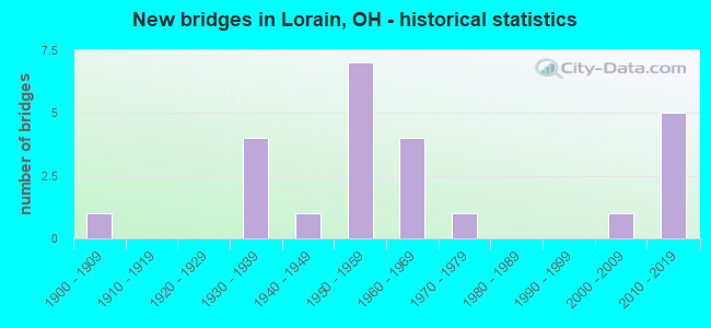
- New bridges - historical statistics
- 11900-1909
- 41930-1939
- 11940-1949
- 71950-1959
- 41960-1969
- 11970-1979
- 12000-2009
- 52010-2019

- Reconstructed bridges - Historical Statistics
- 11950-1959
- 11960-1969
- 01970-1979
- 11980-1989
- 11990-1999
- 02000-2009
- 02010-2019
- 12020-2022


- Bridge Condition - Deck
- 25.0%Excellent
- 6.3%Very good
- 43.8%Good
- 12.5%Satisfactory
- 6.3%Fair
- 6.3%Poor

- Bridge Condition - Superstructure
- 25.0%Excellent
- 12.5%Very good
- 25.0%Good
- 12.5%Satisfactory
- 18.8%Fair
- 6.3%Poor

- Bridge Condition - Substructure
- 25.0%Excellent
- 31.3%Good
- 25.0%Satisfactory
- 18.8%Fair

- Bridge Condition - Channel
- 7.1%Excellent
- 7.1%Very good
- 28.6%Good
- 35.7%Satisfactory
- 21.4%Fair

- Bridge Condition - Culverts
- 25.0%Good
- 25.0%Satisfactory
- 50.0%Poor
Find on map >> Show street view
Structure Number: 4700422, Location: 2.25 MILES EAST OF SR 58 (Lat: 41.411281, Lng: -82.166700), Route carried "on" structure: County highway C0032, Year Built: 1967, Year Reconstructed: 1998, Status: Open, Structure Length: 7.65m (25.10ft), Average Daily Traffic: 18,034 (year 2015), Truck Traffic: 7%, Average Future Daily Traffic: 64,570 (year 2035), Design Load: HS 20+Mod, Features Intersected: OVER LOR-002 -0967, Facility Carried by Structure: C-32 MIDDLE RIDGE
Minimum Vertical Clearance: 30+ m (98+ ft), Kilometerpoint: 13.341, Lanes on structure: 4, Lanes under structure: 4, Base Highway Network: Yes, Owner: State Highway Agency, Approaching Roadway Width: 16.2m (53.1ft), Skew: 3 degrees, Material/Design: Steel continuous, Design/Construction: Stringer/Multi-beam, Number Of Spans In Main Unit: 4, Length of Maximum Span: 20.7m (67.9ft), Curb-To-Curb Width: 18.3m (60.0ft), Out-to-Out Width: 19.5m (64.0ft)
Condition: Deck: Good, Superstructure: Very good, Substructure: Satisfactory, Operating Rating: 55.1 metric tons, Method Used To Determine Operating Rating: Load and Resistance Factor Rating (LRFR) rating reported by rating factor(RF) method using HL-93 loadings, Inventory Rating: 42.1 metric tons, Method Used To Determine Inventory Rating: Load and Resistance Factor Rating (LRFR) rating reported by rating factor(RF) method using HL-93 loadings, Structural Evaluation: Equal to present minimum criteria, Deck Geometry: Somewhat better than minimum adequacy, Underclear: High priority of corrective action, Approach Roadway Alignment: Better than present minimum criteria, Designated Inspection Frequency: Every 12 months, Inspection Date: November 2021, Deck Structure Type: Concrete Cast-file-Place, Wearing Surface/Protective System: Wearing Surface: Monolithic Concrete, Deck Protection: Epoxy Coated Reinforcing
Find on map >> Show street view
Structure Number: 4700503, Location: 3.04 Miles East of SR 58 (Lat: 41.408169, Lng: -82.152719), Route carried "on" structure: State highway 2, Year Built: 2015, Status: Open, Structure Length: 5.44m (17.85ft), Average Daily Traffic: 29,571 (year 2015), Truck Traffic: 10%, Average Future Daily Traffic: 41,045 (year 2035), Design Load: HL 93, Features Intersected: OVER CONRAIL (ABANDONED)
Minimum Vertical Clearance: 30+ m (98+ ft), Kilometerpoint: 16.834, Lanes on structure: 2, Base Highway Network: Yes, Owner: State Highway Agency, Approaching Roadway Width: 13.1m (43.0ft), Skew: 3 degrees, Material/Design: Steel continuous, Design/Construction: Stringer/Multi-beam, Number Of Spans In Main Unit: 3, Length of Maximum Span: 20.7m (67.9ft), Curb-To-Curb Width: 12.2m (40.0ft), Out-to-Out Width: 13.1m (43.0ft)
Condition: Deck: Excellent, Superstructure: Excellent, Substructure: Excellent, Operating Rating: 71.3 metric tons, Method Used To Determine Operating Rating: Load and Resistance Factor Rating (LRFR) rating reported by rating factor(RF) method using HL-93 loadings, Inventory Rating: 55.1 metric tons, Method Used To Determine Inventory Rating: Load and Resistance Factor Rating (LRFR) rating reported by rating factor(RF) method using HL-93 loadings, Structural Evaluation: Superior to present desirable criteria, Deck Geometry: Better than present minimum criteria, Waterway Adequacy: Superior to present desirable criteria, Approach Roadway Alignment: Equal to present desirable criteria, Designated Inspection Frequency: Every 24 months, Inspection Date: June 2021, Deck Structure Type: Concrete Cast-file-Place, Wearing Surface/Protective System: Wearing Surface: Monolithic Concrete, Membrane: Other, Deck Protection: Epoxy Coated Reinforcing
Find on map >> Show street view
Structure Number: 4700538, Location: 3.04 MILES EAST OF SR 58 (Lat: 41.407889, Lng: -82.152811), Route carried "on" structure: State highway 2, Year Built: 2016, Status: Open, Structure Length: 5.44m (17.85ft), Average Daily Traffic: 29,571 (year 2015), Truck Traffic: 10%, Average Future Daily Traffic: 41,045 (year 2035), Design Load: HL 93, Features Intersected: OVER CONRAIL (ABANDONED)
Minimum Vertical Clearance: 30+ m (98+ ft), Kilometerpoint: 16.834, Lanes on structure: 2, Base Highway Network: Yes, Owner: State Highway Agency, Approaching Roadway Width: 12.2m (40.0ft), Skew: 3 degrees, Material/Design: Steel continuous, Design/Construction: Stringer/Multi-beam, Number Of Spans In Main Unit: 3, Length of Maximum Span: 20.7m (67.9ft), Curb-To-Curb Width: 12.2m (40.0ft), Out-to-Out Width: 13.1m (43.0ft)
Condition: Deck: Excellent, Superstructure: Excellent, Substructure: Excellent, Operating Rating: 71.3 metric tons, Method Used To Determine Operating Rating: Load and Resistance Factor Rating (LRFR) rating reported by rating factor(RF) method using HL-93 loadings, Inventory Rating: 55.1 metric tons, Method Used To Determine Inventory Rating: Load and Resistance Factor Rating (LRFR) rating reported by rating factor(RF) method using HL-93 loadings, Structural Evaluation: Superior to present desirable criteria, Deck Geometry: Better than present minimum criteria, Waterway Adequacy: Superior to present desirable criteria, Approach Roadway Alignment: Equal to present desirable criteria, Designated Inspection Frequency: Every 24 months, Inspection Date: June 2021, Deck Structure Type: Concrete Cast-file-Place, Wearing Surface/Protective System: Wearing Surface: Monolithic Concrete, Membrane: Epoxy
Find on map >> Show street view
Structure Number: 4700554, Location: 3.28 miles East of SR 58 (Lat: 41.406300, Lng: -82.149169), Route carried "on" structure: State highway 2, Year Built: 2015, Status: Open, Structure Length: 5.08m (16.67ft), Average Daily Traffic: 29,571 (year 2015), Truck Traffic: 10%, Average Future Daily Traffic: 41,045 (year 2035), Design Load: Railroad, Features Intersected: OVER MURRAY RIDGE TH-54
Minimum Vertical Clearance: 30+ m (98+ ft), Kilometerpoint: 17.220, Lanes on structure: 2, Lanes under structure: 2, Base Highway Network: Yes, Owner: State Highway Agency, Approaching Roadway Width: 15.2m (49.9ft), Skew: 3 degrees, Material/Design: Steel continuous, Design/Construction: Stringer/Multi-beam, Number Of Spans In Main Unit: 3, Length of Maximum Span: 20.9m (68.6ft), Curb-To-Curb Width: 15.2m (49.9ft), Out-to-Out Width: 16.2m (53.1ft)
Condition: Deck: Excellent, Superstructure: Excellent, Substructure: Excellent, Operating Rating: 84.2 metric tons, Method Used To Determine Operating Rating: Load and Resistance Factor Rating (LRFR) rating reported by rating factor(RF) method using HL-93 loadings, Inventory Rating: 38.9 metric tons, Method Used To Determine Inventory Rating: Load and Resistance Factor Rating (LRFR) rating reported by rating factor(RF) method using HL-93 loadings, Structural Evaluation: Superior to present desirable criteria, Deck Geometry: Superior to present desirable criteria, Underclear: Better than present minimum criteria, Approach Roadway Alignment: Meets minimum limits, Designated Inspection Frequency: Every 24 months, Inspection Date: June 2021, Deck Structure Type: Concrete Cast-file-Place, Wearing Surface/Protective System: Wearing Surface: Monolithic Concrete, Membrane: Other, Deck Protection: Epoxy Coated Reinforcing
Find on map >> Show street view
Structure Number: 4700589, Location: 3.28 Miles East of SR 58 (Lat: 41.405939, Lng: -82.148950), Route carried "on" structure: State highway 2, Year Built: 2016, Status: Open, Structure Length: 5.19m (17.03ft), Average Daily Traffic: 29,571 (year 2015), Truck Traffic: 10%, Average Future Daily Traffic: 41,045 (year 2035), Design Load: HL 93, Features Intersected: OVER MURRAY RIDGE TH-54
Minimum Vertical Clearance: 30+ m (98+ ft), Kilometerpoint: 17.220, Lanes on structure: 2, Lanes under structure: 2, Base Highway Network: Yes, Owner: State Highway Agency, Approaching Roadway Width: 13.1m (43.0ft), Skew: 3 degrees, Material/Design: Steel continuous, Design/Construction: Stringer/Multi-beam, Number Of Spans In Main Unit: 3, Length of Maximum Span: 21.3m (69.9ft), Curb-To-Curb Width: 12.2m (40.0ft), Out-to-Out Width: 13.1m (43.0ft)
Condition: Deck: Excellent, Superstructure: Excellent, Substructure: Excellent, Operating Rating: 84.2 metric tons, Method Used To Determine Operating Rating: Load and Resistance Factor Rating (LRFR) rating reported by rating factor(RF) method using HL-93 loadings, Inventory Rating: 64.8 metric tons, Method Used To Determine Inventory Rating: Load and Resistance Factor Rating (LRFR) rating reported by rating factor(RF) method using HL-93 loadings, Structural Evaluation: Superior to present desirable criteria, Deck Geometry: Better than present minimum criteria, Underclear: Better than present minimum criteria, Approach Roadway Alignment: Equal to present desirable criteria, Designated Inspection Frequency: Every 24 months, Inspection Date: June 2021, Deck Structure Type: Concrete Cast-file-Place, Wearing Surface/Protective System: Wearing Surface: Monolithic Concrete, Deck Protection: Epoxy Coated Reinforcing
Find on map >> Show street view
Structure Number: 4700694, Location: .64 MI E OF BAUMHART RD (Lat: 41.430419, Lng: -82.268319), Route carried "on" structure: US 6, Year Built: 1932, Year Reconstructed: 1956, Status: Open, Structure Length: 0.76m (2.49ft), Average Daily Traffic: 7,249 (year 2015), Truck Traffic: 3%, Average Future Daily Traffic: 10,062 (year 2035), Design Load: H 20, Features Intersected: QUARRY CREEK
Minimum Vertical Clearance: 30+ m (98+ ft), Kilometerpoint: 6.759, Lanes on structure: 4, Base Highway Network: Yes, Owner: State Highway Agency, Approaching Roadway Width: 23.2m (76.1ft), Skew: 2 degrees, Material/Design: Concrete, Design/Construction: Culvert, Number Of Spans In Main Unit: 1, Length of Maximum Span: 6.7m (22.0ft)
Condition: Channel: Satisfactory, Culverts: Good, Operating Rating: 42.1 metric tons, Method Used To Determine Operating Rating: Load Factor (LF) rating reported by rating factor (RF) method using MS18 loading, Inventory Rating: 32.4 metric tons, Method Used To Determine Inventory Rating: Load Factor (LF) rating reported by rating factor (RF) method using MS18 loading, Structural Evaluation: Better than present minimum criteria, Waterway Adequacy: Equal to present desirable criteria, Approach Roadway Alignment: Equal to present desirable criteria, Designated Inspection Frequency: Every 24 months, Inspection Date: July 2021
Find on map >> Show street view
Structure Number: 4700724, Location: 1.76 MI E OF BAUMHART RD (Lat: 41.435961, Lng: -82.248439), Route carried "on" structure: US 6, Year Built: 1956, Status: Open, Structure Length: 4.05m (13.29ft), Average Daily Traffic: 7,249 (year 2015), Truck Traffic: 3%, Average Future Daily Traffic: 10,062 (year 2035), Design Load: H 20, Features Intersected: BEAVER CREEK
Minimum Vertical Clearance: 30+ m (98+ ft), Kilometerpoint: 8.562, Lanes on structure: 4, Base Highway Network: Yes, Owner: State Highway Agency, Approaching Roadway Width: 21.9m (71.9ft), Material/Design: Steel continuous, Design/Construction: Stringer/Multi-beam, Number Of Spans In Main Unit: 3, Length of Maximum Span: 14.3m (46.9ft), Curb-To-Curb Width: 22.0m (72.2ft), Out-to-Out Width: 22.0m (72.2ft)
Condition: Deck: Good, Superstructure: Good, Substructure: Good, Channel: Fair, Operating Rating: 58.3 metric tons, Method Used To Determine Operating Rating: Load and Resistance Factor Rating (LRFR) rating reported by rating factor(RF) method using HL-93 loadings, Inventory Rating: 45.4 metric tons, Method Used To Determine Inventory Rating: Load and Resistance Factor Rating (LRFR) rating reported by rating factor(RF) method using HL-93 loadings, Structural Evaluation: Better than present minimum criteria, Deck Geometry: Superior to present desirable criteria, Waterway Adequacy: Equal to present desirable criteria, Approach Roadway Alignment: Equal to present desirable criteria, Length Of Structure Improvement: 4.94m (16.21ft), Designated Inspection Frequency: Every 24 months, Underwater Inspection Frequency: Every 60 months, Inspection Date: June 2021, Underwater Inspection Date: October 2020, Roadway Improvement Cost: $244,000, Total Project Cost: $812,000, Deck Structure Type: Concrete Cast-file-Place, Wearing Surface/Protective System: Wearing Surface: Integral Concrete
Find on map >> Show street view
Structure Number: 4700813, Location: 0.1 MILE EAST OF SR 57 (Lat: 41.468650, Lng: -82.177769), Route carried "on" structure: US 6, Year Built: 1939, Year Reconstructed: 2020, Status: Open, Structure Length: 32.10m (105.31ft), Average Daily Traffic: 14,477 (year 2015), Truck Traffic: 2%, Average Future Daily Traffic: 20,094 (year 2035), Design Load: H 20, Features Intersected: OVER BLACK RIVER
Minimum Vertical Clearance: 30+ m (98+ ft), Kilometerpoint: 15.562, Lanes on structure: 4, Lanes under structure: 2, Base Highway Network: Yes, Owner: State Highway Agency, Approaching Roadway Width: 14.3m (46.9ft), Skew: 30 degrees, Navigation Control: Yes ( Vertical Clearance: 10.1m (33.1ft), Horizontal Clearance: 89.9m (294.9ft)), Material/Design: Steel, Design/Construction: Movable - Bascule, Number Of Spans In Main Unit: 1, Number Of Approach Spans: 11, Length of Maximum Span: 100.6m (330.1ft), Curb or Sidewalk Widths: Left: 2.3m (7.5ft), Right: 2.3m (7.5ft), Curb-To-Curb Width: 14.3m (46.9ft), Out-to-Out Width: 18.9m (62.0ft)
Condition: Deck: Good, Superstructure: Fair, Substructure: Satisfactory, Channel: Good, Operating Rating: 38.9 metric tons, Method Used To Determine Operating Rating: Load Factor (LF) rating reported by rating factor (RF) method using MS18 loading, Inventory Rating: 22.7 metric tons, Method Used To Determine Inventory Rating: Load Factor (LF) rating reported by rating factor (RF) method using MS18 loading, Structural Evaluation: Somewhat better than minimum adequacy, Deck Geometry: High priority of replacement, Underclear: Meets minimum limits, Waterway Adequacy: Superior to present desirable criteria, Approach Roadway Alignment: Equal to present minimum criteria, Length Of Structure Improvement: 39.99m (131.20ft), Designated Inspection Frequency: Every 12 months, Critical Feature Inspection Frequency: Every 12 months, Inspection Date: October 2021, Critical Feature Inspection Date: September 2021, Bridge Improvement Cost: $4,619,000, Roadway Improvement Cost: $462,000, Total Project Cost: $5,297,000, Deck Structure Type: Closed Grating, Wearing Surface/Protective System: Wearing Surface: Integral Concrete
Find on map >> Show street view
Structure Number: 470303, Location: 1.31 MI NORTH OF SR 254 (Lat: 41.437889, Lng: -82.120039), Route carried "on" structure: State highway 57, Year Built: 1950, Status: Open, Structure Length: 0.85m (2.79ft), Average Daily Traffic: 16,389 (year 2015), Truck Traffic: 6%, Average Future Daily Traffic: 22,748 (year 2035), Design Load: HS 20, Features Intersected: 36TH STREET DITCH
Minimum Vertical Clearance: 30+ m (98+ ft), Kilometerpoint: 36.436, Lanes on structure: 4, Base Highway Network: Yes, Owner: State Highway Agency, Approaching Roadway Width: 18.3m (60.0ft), Material/Design: Concrete, Design/Construction: Slab, Number Of Spans In Main Unit: 1, Length of Maximum Span: 7.9m (25.9ft), Curb-To-Curb Width: 19.8m (65.0ft), Out-to-Out Width: 24.4m (80.1ft)
Condition: Deck: Good, Superstructure: Good, Substructure: Good, Channel: Satisfactory, Operating Rating: 48.6 metric tons, Method Used To Determine Operating Rating: Load Factor (LF) rating reported by rating factor (RF) method using MS18 loading, Inventory Rating: 29.2 metric tons, Method Used To Determine Inventory Rating: Load Factor (LF) rating reported by rating factor (RF) method using MS18 loading, Structural Evaluation: Better than present minimum criteria, Deck Geometry: Better than present minimum criteria, Waterway Adequacy: Superior to present desirable criteria, Approach Roadway Alignment: Equal to present desirable criteria, Designated Inspection Frequency: Every 24 months, Inspection Date: July 2021, Deck Structure Type: Concrete Cast-file-Place, Wearing Surface/Protective System: Wearing Surface: Bituminous
Find on map >> Show street view
Structure Number: 470351, Location: .57 MILES NORTH OF SR 2 (Lat: 41.422161, Lng: -82.208800), Route carried "on" structure: State highway 58, Year Built: 1965, Status: Open, Structure Length: 2.44m (8.01ft), Average Daily Traffic: 19,498 (year 2015), Truck Traffic: 2%, Average Future Daily Traffic: 27,063 (year 2035), Design Load: H 20, Features Intersected: BRANCH OF BEAVER CREEK
Minimum Vertical Clearance: 30+ m (98+ ft), Kilometerpoint: 40.089, Lanes on structure: 4, Base Highway Network: Yes, Owner: State Highway Agency, Approaching Roadway Width: 21.9m (71.9ft), Material/Design: Concrete continuous, Design/Construction: Slab, Number Of Spans In Main Unit: 3, Length of Maximum Span: 8.5m (27.9ft), Curb-To-Curb Width: 20.7m (67.9ft), Out-to-Out Width: 20.7m (67.9ft)
Condition: Deck: Poor, Superstructure: Poor, Substructure: Fair, Channel: Satisfactory, Operating Rating: 42.1 metric tons, Method Used To Determine Operating Rating: Load Factor (LF) rating reported by rating factor (RF) method using MS18 loading, Inventory Rating: 32.4 metric tons, Method Used To Determine Inventory Rating: Load Factor (LF) rating reported by rating factor (RF) method using MS18 loading, Structural Evaluation: Meets minimum limits, Deck Geometry: Superior to present desirable criteria, Waterway Adequacy: Equal to present desirable criteria, Approach Roadway Alignment: Equal to present desirable criteria, Designated Inspection Frequency: Every 12 months, Inspection Date: November 2021, Deck Structure Type: Concrete Cast-file-Place, Wearing Surface/Protective System: Wearing Surface: Integral Concrete
Find on map >> Show street view
Structure Number: 4703634, Location: 1.92 MILES NORTH OF SR 2 (Lat: 41.440169, Lng: -82.202489), Route carried "on" structure: State highway 58, Year Built: 1965, Status: Open, Structure Length: 1.83m (6.00ft), Average Daily Traffic: 9,858 (year 2015), Truck Traffic: 3%, Average Future Daily Traffic: 13,683 (year 2035), Design Load: HS 20, Features Intersected: MARTIN RUN
Minimum Vertical Clearance: 30+ m (98+ ft), Kilometerpoint: 42.261, Lanes on structure: 4, Base Highway Network: Yes, Owner: State Highway Agency, Approaching Roadway Width: 21.9m (71.9ft), Material/Design: Concrete continuous, Design/Construction: Slab, Number Of Spans In Main Unit: 3, Length of Maximum Span: 6.4m (21.0ft), Curb-To-Curb Width: 20.7m (67.9ft), Out-to-Out Width: 20.7m (67.9ft)
Condition: Deck: Good, Superstructure: Good, Substructure: Satisfactory, Channel: Good, Operating Rating: 42.1 metric tons, Method Used To Determine Operating Rating: Allowable Stress (AS) rating reported by rating factor (RF) method using MS18 loading, Inventory Rating: 25.9 metric tons, Method Used To Determine Inventory Rating: Allowable Stress (AS) rating reported by rating factor (RF) method using MS18 loading, Structural Evaluation: Equal to present minimum criteria, Deck Geometry: Superior to present desirable criteria, Waterway Adequacy: Equal to present desirable criteria, Approach Roadway Alignment: Equal to present desirable criteria, Designated Inspection Frequency: Every 12 months, Inspection Date: November 2021, Deck Structure Type: Concrete Cast-file-Place, Wearing Surface/Protective System: Wearing Surface: Integral Concrete
Find on map >> Show street view
Structure Number: 4707435, Location: .39 MI EAST OF US 6 INT (Lat: 41.447150, Lng: -82.222669), Route carried "on" structure: State highway 611, Year Built: 1956, Status: Open, Structure Length: 0.91m (2.99ft), Average Daily Traffic: 2,417 (year 2015), Truck Traffic: 9%, Average Future Daily Traffic: 3,355 (year 2035), Design Load: HS 15, Features Intersected: MARTINS RUN
Minimum Vertical Clearance: 30+ m (98+ ft), Kilometerpoint: 0.499, Lanes on structure: 2, Owner: State Highway Agency, Approaching Roadway Width: 12.2m (40.0ft), Skew: 2 degrees, Material/Design: Steel, Design/Construction: Culvert, Number Of Spans In Main Unit: 2, Length of Maximum Span: 4.3m (14.1ft)
Condition: Channel: Satisfactory, Culverts: Poor, Operating Rating: 42.1 metric tons, Method Used To Determine Operating Rating: Load Factor (LF) rating reported by rating factor (RF) method using MS18 loading, Inventory Rating: 32.4 metric tons, Method Used To Determine Inventory Rating: Load Factor (LF) rating reported by rating factor (RF) method using MS18 loading, Structural Evaluation: Meets minimum limits, Waterway Adequacy: Equal to present desirable criteria, Approach Roadway Alignment: Equal to present desirable criteria, Designated Inspection Frequency: Every 12 months, Inspection Date: August 2021
Find on map >> Show street view
Structure Number: 4707443, Location: .5 MI. EAST OF SR.57 (Lat: 41.454750, Lng: -82.160411), Route carried "on" structure: State highway 611, Year Built: 1939, Year Reconstructed: 1989, Status: Open, Structure Length: 51.94m (170.41ft), Average Daily Traffic: 14,500 (year 2015), Truck Traffic: 6%, Average Future Daily Traffic: 15,280 (year 2035), Design Load: HS 20+Mod, Features Intersected: BLACK RIVER SHIP CHANNEL
Minimum Vertical Clearance: 4.78m (15.68ft), Kilometerpoint: 5.536, Lanes on structure: 4, Base Highway Network: Yes, Owner: State Highway Agency, Approaching Roadway Width: 13.4m (44.0ft), Navigation Control: Yes ( Vertical Clearance: 29.6m (97.1ft), Horizontal Clearance: 67.1m (220.1ft)), Material/Design: Steel, Design/Construction: Truss - Thru, Number Of Spans In Main Unit: 6, Length of Maximum Span: 118.9m (390.1ft), Curb or Sidewalk Widths: Left: 1.8m (5.9ft), Right: 0.0m, Curb-To-Curb Width: 12.8m (42.0ft), Out-to-Out Width: 15.2m (49.9ft)
Condition: Deck: Good, Superstructure: Satisfactory, Substructure: Good, Channel: Excellent, Operating Rating: 42.1 metric tons, Method Used To Determine Operating Rating: Allowable Stress (AS) rating reported by rating factor (RF) method using MS18 loading, Inventory Rating: 32.4 metric tons, Method Used To Determine Inventory Rating: Allowable Stress (AS) rating reported by rating factor (RF) method using MS18 loading, Structural Evaluation: Equal to present minimum criteria, Deck Geometry: High priority of replacement, Waterway Adequacy: Superior to present desirable criteria, Approach Roadway Alignment: Better than present minimum criteria, Length Of Structure Improvement: 51.82m (170.01ft), Designated Inspection Frequency: Every 12 months, Critical Feature Inspection Frequency: Every 24 months, Inspection Date: October 2021, Critical Feature Inspection Date: October 2021, Deck Structure Type: Closed Grating, Wearing Surface/Protective System: Wearing Surface: Monolithic Concrete, Deck Protection: Epoxy Coated Reinforcing
Find on map >> Show street view
Structure Number: 4707508, Location: .09 MILES EAST OF US 6 (Lat: 41.447381, Lng: -82.223381), Route carried "on" structure: State highway 611D, Year Built: 1956, Status: Open, Structure Length: 7.35m (24.11ft), Average Daily Traffic: 1,378 (year 2015), Truck Traffic: 4%, Average Future Daily Traffic: 1,913 (year 2035), Design Load: HS 20, Features Intersected: OVER LOR-006-0685
Minimum Vertical Clearance: 30+ m (98+ ft), Kilometerpoint: 0.145, Lanes on structure: 2, Lanes under structure: 4, Owner: State Highway Agency, Approaching Roadway Width: 11.0m (36.1ft), Skew: 4 degrees, Material/Design: Steel continuous, Design/Construction: Stringer/Multi-beam, Number Of Spans In Main Unit: 4, Length of Maximum Span: 20.1m (65.9ft), Curb-To-Curb Width: 7.3m (24.0ft), Out-to-Out Width: 9.4m (30.8ft)
Condition: Deck: Fair, Superstructure: Satisfactory, Substructure: Satisfactory, Operating Rating: 38.9 metric tons, Method Used To Determine Operating Rating: Load and Resistance Factor Rating (LRFR) rating reported by rating factor(RF) method using HL-93 loadings, Inventory Rating: 29.2 metric tons, Method Used To Determine Inventory Rating: Load and Resistance Factor Rating (LRFR) rating reported by rating factor(RF) method using HL-93 loadings, Structural Evaluation: Equal to present minimum criteria, Deck Geometry: High priority of replacement, Underclear: High priority of corrective action, Approach Roadway Alignment: Equal to present desirable criteria, Designated Inspection Frequency: Every 12 months, Inspection Date: June 2021, Deck Structure Type: Concrete Cast-file-Place, Wearing Surface/Protective System: Wearing Surface: Bituminous
Find on map >> Show street view
Structure Number: 4707532, Location: 3.27 MI E OF BAUMHART RD (Lat: 41.447611, Lng: -82.222769), Route carried "on" structure: US 6, Year Built: 1956, Status: Open, Structure Length: 0.91m (2.99ft), Average Daily Traffic: 7,584 (year 2015), Truck Traffic: 3%, Average Future Daily Traffic: 10,527 (year 2035), Design Load: H 15, Features Intersected: MARTINS RUN
Minimum Vertical Clearance: 30+ m (98+ ft), Kilometerpoint: 10.992, Lanes on structure: 4, Base Highway Network: Yes, Owner: State Highway Agency, Approaching Roadway Width: 20.7m (67.9ft), Material/Design: Steel, Design/Construction: Culvert, Number Of Spans In Main Unit: 2, Length of Maximum Span: 4.3m (14.1ft)
Condition: Channel: Satisfactory, Culverts: Poor, Operating Rating: 42.1 metric tons, Method Used To Determine Operating Rating: Load Factor (LF) rating reported by rating factor (RF) method using MS18 loading, Inventory Rating: 32.4 metric tons, Method Used To Determine Inventory Rating: Load Factor (LF) rating reported by rating factor (RF) method using MS18 loading, Structural Evaluation: Meets minimum limits, Waterway Adequacy: Equal to present desirable criteria, Approach Roadway Alignment: Equal to present desirable criteria, Designated Inspection Frequency: Every 12 months, Inspection Date: August 2021
Find on map >> Show street view
Structure Number: 4734513, Location: .10MI.EAST OF SR (Lat: 41.418269, Lng: -82.206419), Route carried "on" structure: County highway C0033, Year Built: 1941, Year Reconstructed: 1974, Status: Posted for load, Structure Length: 1.13m (3.71ft), Average Daily Traffic: 10,706 (year 2015), Truck Traffic: 1%, Average Future Daily Traffic: 14,860 (year 2035), Features Intersected: BEAVER CR C.P.PARK, Facility Carried by Structure: COOPER-FOSTER PK.
Minimum Vertical Clearance: 30+ m (98+ ft), Kilometerpoint: 11.909, Lanes on structure: 3, Owner: County Highway Agency, Approaching Roadway Width: 15.2m (49.9ft), Material/Design: Concrete, Design/Construction: Tee Beam, Number Of Spans In Main Unit: 1, Length of Maximum Span: 9.8m (32.2ft), Curb or Sidewalk Widths: Left: 0.0m, Right: 1.7m (5.6ft), Curb-To-Curb Width: 13.4m (44.0ft), Out-to-Out Width: 15.2m (49.9ft)
Condition: Deck: Satisfactory, Superstructure: Fair, Substructure: Fair, Channel: Good, Operating Rating: 38.9 metric tons, Method Used To Determine Operating Rating: Load Factor (LF) rating reported by rating factor (RF) method using MS18 loading, Inventory Rating: 22.7 metric tons, Method Used To Determine Inventory Rating: Load Factor (LF) rating reported by rating factor (RF) method using MS18 loading, Structural Evaluation: Somewhat better than minimum adequacy, Deck Geometry: Somewhat better than minimum adequacy, Waterway Adequacy: Better than present minimum criteria, Approach Roadway Alignment: Equal to present desirable criteria, Bridge Posting: Required (Relationship of Operating Rating to Maximum Legal Load: 10.0 - 19.9% below), Designated Inspection Frequency: Every 12 months, Inspection Date: November 2021, Deck Structure Type: Concrete Cast-file-Place, Wearing Surface/Protective System: Wearing Surface: Bituminous
Find on map >> Show street view
Structure Number: 4735072, Location: .34MI.WEST OF (Lat: 41.443250, Lng: -82.106950), Route carried "on" structure: City street M0023, Year Built: 1977, Status: Open, Structure Length: 9.30m (30.51ft), Average Daily Traffic: 8,129 (year 2015), Truck Traffic: 2%, Average Future Daily Traffic: 11,283 (year 2035), Design Load: H 20, Features Intersected: BLACK RIVER EAST 31ST ST, Facility Carried by Structure: 31 ST.
Minimum Vertical Clearance: 30+ m (98+ ft), Kilometerpoint: 1.110, Lanes on structure: 4, Owner: County Highway Agency, Approaching Roadway Width: 20.1m (65.9ft), Skew: 1 degrees, Material/Design: Steel continuous, Design/Construction: Stringer/Multi-beam, Number Of Spans In Main Unit: 4, Length of Maximum Span: 25.6m (84.0ft), Curb or Sidewalk Widths: Left: 1.5m (4.9ft), Right: 1.5m (4.9ft), Curb-To-Curb Width: 15.9m (52.2ft), Out-to-Out Width: 19.5m (64.0ft)
Condition: Deck: Good, Superstructure: Good, Substructure: Good, Channel: Very good, Operating Rating: 64.8 metric tons, Method Used To Determine Operating Rating: Load Factor (LF) rating reported by rating factor (RF) method using MS18 loading, Inventory Rating: 38.9 metric tons, Method Used To Determine Inventory Rating: Load Factor (LF) rating reported by rating factor (RF) method using MS18 loading, Structural Evaluation: Better than present minimum criteria, Deck Geometry: Meets minimum limits, Waterway Adequacy: Equal to present desirable criteria, Approach Roadway Alignment: Equal to present desirable criteria, Designated Inspection Frequency: Every 24 months, Underwater Inspection Frequency: Every 60 months, Inspection Date: November 2021, Underwater Inspection Date: October 2019, Deck Structure Type: Concrete Cast-file-Place, Wearing Surface/Protective System: Wearing Surface: Bituminous
Find on map >> Show street view
Structure Number: 4761421, Location: .19 MI. W OF KILBE RD (Lat: 41.426189, Lng: -82.233019), Route carried "on" structure: City street 92, Year Built: 2001, Status: Open, Structure Length: 1.68m (5.51ft), Average Daily Traffic: 6,132 (year 2015), Truck Traffic: 2%, Average Future Daily Traffic: 8,511 (year 2035), Design Load: HS 20+Mod, Features Intersected: BEAVER CREEK LONGBROOK R, Facility Carried by Structure: LONGBROOK RD
Minimum Vertical Clearance: 30+ m (98+ ft), Kilometerpoint: 0.563, Lanes on structure: 2, Owner: City or Municipal Highway Agency, Approaching Roadway Width: 6.4m (21.0ft), Skew: 1 degrees, Material/Design: Prestressed concrete, Design/Construction: Box Beam or Girders - Multiple, Number Of Spans In Main Unit: 1, Length of Maximum Span: 16.5m (54.1ft), Curb or Sidewalk Widths: Left: 1.5m (4.9ft), Right: 1.5m (4.9ft), Curb-To-Curb Width: 7.9m (25.9ft), Out-to-Out Width: 11.6m (38.1ft)
Condition: Deck: Very good, Superstructure: Very good, Substructure: Good, Channel: Good, Operating Rating: 77.8 metric tons, Method Used To Determine Operating Rating: Load Factor (LF) rating reported by rating factor (RF) method using MS18 loading, Inventory Rating: 42.1 metric tons, Method Used To Determine Inventory Rating: Load Factor (LF) rating reported by rating factor (RF) method using MS18 loading, Structural Evaluation: Better than present minimum criteria, Deck Geometry: High priority of replacement, Waterway Adequacy: Equal to present desirable criteria, Approach Roadway Alignment: Better than present minimum criteria, Designated Inspection Frequency: Every 24 months, Inspection Date: November 2020, Deck Structure Type: Concrete Cast-file-Place, Wearing Surface/Protective System: Wearing Surface: Monolithic Concrete
Find on map >> Show street view
Structure Number: 4761537, Location: 175 FT N OF ROBINHOOD DR (Lat: 41.445611, Lng: -82.220511), Route carried "on" structure: City street M0002, Year Built: 1955, Status: Open, Structure Length: 0.67m (2.20ft), Average Daily Traffic: 3,295 (year 2015), Truck Traffic: 5%, Average Future Daily Traffic: 4,573 (year 2035), Design Load: HS 15, Features Intersected: MARTINS RUN SHERWOOD DR, Facility Carried by Structure: SHERWOOD DR
Minimum Vertical Clearance: 30+ m (98+ ft), Kilometerpoint: 0.402, Lanes on structure: 2, Owner: City or Municipal Highway Agency, Approaching Roadway Width: 8.8m (28.9ft), Skew: 1 degrees, Material/Design: Steel, Design/Construction: Culvert, Number Of Spans In Main Unit: 2, Length of Maximum Span: 3.0m (9.8ft)
Condition: Channel: Fair, Culverts: Satisfactory, Operating Rating: 97.2 metric tons, Method Used To Determine Operating Rating: Load Factor (LF) rating reported by rating factor (RF) method using MS18 loading, Inventory Rating: 77.8 metric tons, Method Used To Determine Inventory Rating: Load Factor (LF) rating reported by rating factor (RF) method using MS18 loading, Structural Evaluation: Equal to present minimum criteria, Waterway Adequacy: Better than present minimum criteria, Approach Roadway Alignment: Somewhat better than minimum adequacy, Designated Inspection Frequency: Every 12 months, Inspection Date: December 2021
Find on map >> Show street view
Structure Number: 4761766, Location: 0.38 MI WEST OF SR 58 (Lat: 41.441739, Lng: -82.209781), Route carried "on" structure: City street MEIST, Year Built: 1900, Status: Posted for load, Structure Length: 1.01m (3.31ft), Average Daily Traffic: 3,295 (year 2015), Truck Traffic: 5%, Average Future Daily Traffic: 4,573 (year 2035), Design Load: H 20, Features Intersected: MARTINS RUN
Minimum Vertical Clearance: 30+ m (98+ ft), Kilometerpoint: 1.529, Lanes on structure: 2, Owner: City or Municipal Highway Agency, Approaching Roadway Width: 7.9m (25.9ft), Material/Design: Concrete, Design/Construction: Slab, Number Of Spans In Main Unit: 1, Length of Maximum Span: 9.7m (31.8ft), Curb-To-Curb Width: 7.3m (24.0ft), Out-to-Out Width: 8.2m (26.9ft)
Condition: Deck: Satisfactory, Superstructure: Fair, Substructure: Fair, Channel: Fair, Operating Rating: 32.4 metric tons, Method Used To Determine Operating Rating: Load Factor (LF) rating reported by rating factor (RF) method using MS18 loading, Inventory Rating: 19.4 metric tons, Method Used To Determine Inventory Rating: Load Factor (LF) rating reported by rating factor (RF) method using MS18 loading, Structural Evaluation: Somewhat better than minimum adequacy, Deck Geometry: High priority of replacement, Waterway Adequacy: Equal to present desirable criteria, Approach Roadway Alignment: Equal to present desirable criteria, Bridge Posting: Required (Relationship of Operating Rating to Maximum Legal Load: 30.0 - 39.9% below), Designated Inspection Frequency: Every 12 months, Inspection Date: December 2021, Deck Structure Type: Concrete Cast-file-Place, Wearing Surface/Protective System: Wearing Surface: Bituminous
Find on map >> Show street view
Structure Number: 4700422, Location: 2.25 MILES EAST OF SR 58 (Lat: 41.411281, Lng: -82.166700), Route carried "under" structure: State highway 16, Year Built: 1967, Structure Length: 0. m, Average Daily Traffic: 46,520 (year 2015), Truck Traffic: 10%, Features Intersected: UNDER MIDDLE RIDGE CH-32, Facility Carried by Structure: C-32 MIDDLE RIDGE
Minimum Vertical Clearance: 5.01m (16.44ft), Kilometerpoint: 15.562, Lanes on structure: 4, Lanes under structure: 4, Material/Design: Steel continuous, Design/Construction: Stringer/Multi-beam, Length of Maximum Span: 20.7m (67.9ft)
Find on map >> Show street view
Structure Number: 4700554, Location: 3.28 miles East of SR 58 (Lat: 41.406300, Lng: -82.149169), Route carried "under" structure: County highway T0054, Year Built: 2015, Structure Length: 0. m, Average Daily Traffic: 2,032 (year 2015), Truck Traffic: 6%, Features Intersected: SR 2, Facility Carried by Structure: SR 2
Minimum Vertical Clearance: 4.94m (16.21ft), Kilometerpoint: 1.609, Lanes on structure: 2, Lanes under structure: 2, Material/Design: Steel continuous, Design/Construction: Stringer/Multi-beam, Length of Maximum Span: 20.9m (68.6ft)
Find on map >> Show street view
Structure Number: 4700813, Location: 0.1 MILE EAST OF SR 57 (Lat: 41.468650, Lng: -82.177769), Route carried "under" structure: ServiceCity street RVFRT, Year Built: 1939, Structure Length: 0. m, Average Daily Traffic: 400 (year 1900), Features Intersected: UNDER LOR-6-0967(ERIE AV, Facility Carried by Structure: USR 6
Minimum Vertical Clearance: 4.34m (14.24ft), Kilometerpoint: 160.918, Lanes on structure: 4, Lanes under structure: 2, Material/Design: Steel, Design/Construction: Movable - Bascule, Length of Maximum Span: 100.6m (330.1ft)
Find on map >> Show street view
Structure Number: 4707508, Location: .09 MILES EAST OF US 6 (Lat: 41.447381, Lng: -82.223381), Route carried "under" structure: US 6, Year Built: 1956, Structure Length: 0. m, Average Daily Traffic: 7,584 (year 2015), Truck Traffic: 3%, Features Intersected: UNDER LOR-611D-0009L
Minimum Vertical Clearance: 4.95m (16.24ft), Kilometerpoint: 11.024, Lanes on structure: 2, Lanes under structure: 4, Material/Design: Steel continuous, Design/Construction: Stringer/Multi-beam, Length of Maximum Span: 20.1m (65.9ft)