Bridge Statistics for Kenosha, Wisconsin (WI)
Condition, Traffic, Stress, Structural Evaluation, Project Costs
- National Bridge Inventory (NBI) Statistics
- 24Number of bridges
- 154ft / 47.5mTotal length
- $1,731,000Total costs
- 233,600Total average daily traffic
- 10,521Total average daily truck traffic
- National Bridge Inventory (NBI) Registered Bridges for Kenosha
- No street view available for this location
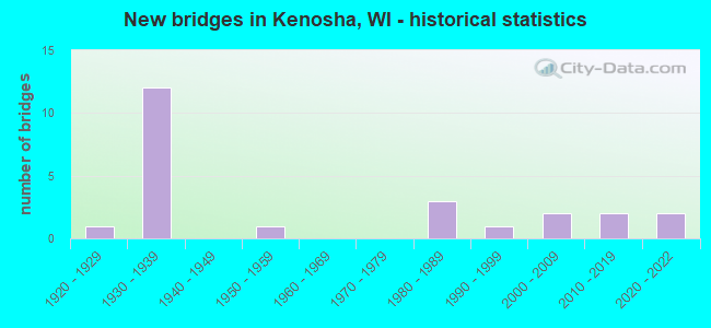
- New bridges - historical statistics
- 11920-1929
- 121930-1939
- 11950-1959
- 31980-1989
- 11990-1999
- 22000-2009
- 22010-2019
- 22020-2022

- Reconstructed bridges - Historical Statistics
- 11980-1989
- 01990-1999
- 02000-2009
- 12010-2019


- Bridge Condition - Deck
- 18.2%Excellent
- 18.2%Very good
- 36.4%Good
- 9.1%Satisfactory
- 18.2%Fair

- Bridge Condition - Superstructure
- 27.3%Excellent
- 45.5%Very good
- 18.2%Good
- 9.1%Fair

- Bridge Condition - Substructure
- 18.2%Excellent
- 36.4%Very good
- 27.3%Good
- 9.1%Satisfactory
- 9.1%Fair

- Bridge Condition - Channel
- 22.2%Excellent
- 44.4%Very good
- 22.2%Good
- 11.1%Fair
Find on map >> Show street view
Structure Number: B300051, Location: 2.4M W JCT CTH B (Lat: 42.575914, Lng: -88.203156), Route carried "on" structure: State highway 50, Year Built: 1986, Status: Open, Structure Length: 7.64m (25.07ft), Average Daily Traffic: 10,750 (year 2019), Truck Traffic: 13%, Average Future Daily Traffic: 12,450 (year 2039), Design Load: HS 20, Features Intersected: FOX RIVER
Minimum Vertical Clearance: 30+ m (98+ ft), Kilometerpoint: 0.000, Lanes on structure: 2, Base Highway Network: Yes, Owner: State Highway Agency, Approaching Roadway Width: 12.2m (40.0ft), Skew: 3 degrees, Material/Design: Prestressed concrete continuous, Design/Construction: Stringer/Multi-beam, Number Of Spans In Main Unit: 3, Length of Maximum Span: 25.2m (82.7ft), Curb-To-Curb Width: 12.2m (40.0ft), Out-to-Out Width: 13.1m (43.0ft)
Condition: Deck: Good, Superstructure: Good, Substructure: Satisfactory, Channel: Fair, Operating Rating: 82.0 metric tons, Method Used To Determine Operating Rating: Load Factor (LF), Inventory Rating: 22.7 metric tons, Method Used To Determine Inventory Rating: Load Factor (LF), Structural Evaluation: Somewhat better than minimum adequacy, Deck Geometry: Better than present minimum criteria, Waterway Adequacy: Superior to present desirable criteria, Approach Roadway Alignment: Equal to present desirable criteria, Designated Inspection Frequency: Every 23 months, Inspection Date: July 2020, Deck Structure Type: Concrete Cast-file-Place, Wearing Surface/Protective System: Wearing Surface: Low Slump Concrete, Deck Protection: Epoxy Coated Reinforcing
Find on map >> Show street view
Structure Number: B300052, Location: 0.2M E JCT STH 32 (Lat: 42.590831, Lng: -87.819592), Route carried "on" structure: City street , Year Built: 1986, Status: Open, Structure Length: 12.05m (39.53ft), Average Daily Traffic: 3,024 (year 2019), Average Future Daily Traffic: 3,326 (year 2039), Design Load: HS 20, Features Intersected: PIKE CREEK LAGOON, Facility Carried by Structure: LRD 50TH ST
Minimum Vertical Clearance: 30+ m (98+ ft), Kilometerpoint: 0.000, Lanes on structure: 2, Owner: City or Municipal Highway Agency, Approaching Roadway Width: 8.5m (27.9ft), Material/Design: Steel continuous, Design/Construction: Stringer/Multi-beam, Number Of Spans In Main Unit: 3, Length of Maximum Span: 51.8m (169.9ft), Curb or Sidewalk Widths: Left: 2.0m (6.6ft), Right: 2.0m (6.6ft), Curb-To-Curb Width: 8.5m (27.9ft), Out-to-Out Width: 13.1m (43.0ft)
Condition: Deck: Fair, Superstructure: Good, Substructure: Good, Channel: Very good, Operating Rating: 49.0 metric tons, Method Used To Determine Operating Rating: Load Factor (LF), Inventory Rating: 29.2 metric tons, Method Used To Determine Inventory Rating: Load Factor (LF), Structural Evaluation: Better than present minimum criteria, Deck Geometry: Meets minimum limits, Waterway Adequacy: Equal to present desirable criteria, Approach Roadway Alignment: Equal to present desirable criteria, Designated Inspection Frequency: Every 24 months, Inspection Date: May 2020, Deck Structure Type: Concrete Cast-file-Place, Wearing Surface/Protective System: Wearing Surface: Low Slump Concrete, Deck Protection: Epoxy Coated Reinforcing
Find on map >> Show street view
Structure Number: B300059, Location: 1.6M N JCT CTH S (Lat: 42.621731, Lng: -87.825036), Route carried "on" structure: State highway 32, Year Built: 1986, Status: Open, Structure Length: 2.69m (8.83ft), Average Daily Traffic: 12,036 (year 2019), Truck Traffic: 3%, Average Future Daily Traffic: 13,239 (year 2039), Design Load: HS 20, Features Intersected: PIKE RIVER
Minimum Vertical Clearance: 30+ m (98+ ft), Kilometerpoint: 0.000, Lanes on structure: 2, Base Highway Network: Yes, Owner: City or Municipal Highway Agency, Approaching Roadway Width: 25.6m (84.0ft), Skew: 3 degrees, Material/Design: Prestressed concrete, Design/Construction: Stringer/Multi-beam, Number Of Spans In Main Unit: 1, Length of Maximum Span: 25.6m (84.0ft), Curb or Sidewalk Widths: Left: 2.0m (6.6ft), Right: 2.0m (6.6ft), Curb-To-Curb Width: 20.7m (67.9ft), Out-to-Out Width: 25.6m (84.0ft)
Condition: Deck: Satisfactory, Superstructure: Very good, Substructure: Very good, Channel: Excellent, Operating Rating: 98.0 metric tons, Method Used To Determine Operating Rating: Load Factor (LF), Inventory Rating: 40.5 metric tons, Method Used To Determine Inventory Rating: Load Factor (LF), Structural Evaluation: Equal to present desirable criteria, Deck Geometry: Superior to present desirable criteria, Waterway Adequacy: Superior to present desirable criteria, Approach Roadway Alignment: Equal to present desirable criteria, Designated Inspection Frequency: Every 24 months, Inspection Date: May 2020, Deck Structure Type: Concrete Cast-file-Place, Wearing Surface/Protective System: Wearing Surface: Monolithic Concrete, Deck Protection: Epoxy Coated Reinforcing
Find on map >> Show street view
Structure Number: B300076, Location: 0.6M E JCT IH 94 TO E (Lat: 42.611500, Lng: -87.941753), Route carried "on" structure: County highway , Year Built: 1995, Status: Open, Structure Length: 1.42m (4.66ft), Average Daily Traffic: 11,400 (year 2019), Average Future Daily Traffic: 8,639 (year 2039), Design Load: HS 20, Features Intersected: KILBOURN ROAD DITCH, Facility Carried by Structure: CTH S
Minimum Vertical Clearance: 30+ m (98+ ft), Kilometerpoint: 0.000, Lanes on structure: 2, Owner: County Highway Agency, Approaching Roadway Width: 13.4m (44.0ft), Skew: 2 degrees, Material/Design: Concrete, Design/Construction: Slab, Number Of Spans In Main Unit: 1, Length of Maximum Span: 13.4m (44.0ft), Curb-To-Curb Width: 13.4m (44.0ft), Out-to-Out Width: 14.0m (45.9ft)
Condition: Deck: Fair, Superstructure: Fair, Substructure: Good, Channel: Good, Operating Rating: 63.7 metric tons, Method Used To Determine Operating Rating: Load Factor (LF), Inventory Rating: 37.3 metric tons, Method Used To Determine Inventory Rating: Load Factor (LF), Structural Evaluation: Somewhat better than minimum adequacy, Deck Geometry: Equal to present minimum criteria, Waterway Adequacy: Somewhat better than minimum adequacy, Approach Roadway Alignment: Equal to present desirable criteria, Designated Inspection Frequency: Every 24 months, Inspection Date: May 2020, Deck Structure Type: Concrete Cast-file-Place, Wearing Surface/Protective System: Wearing Surface: Monolithic Concrete, Deck Protection: Epoxy Coated Reinforcing
Find on map >> Show street view
Structure Number: B300086, Location: AT PIKE RIVER (Lat: 42.608142, Lng: -87.821453), Route carried "on" structure: State highway 32, Year Built: 2005, Status: Open, Structure Length: 2.25m (7.38ft), Average Daily Traffic: 10,600 (year 2019), Average Future Daily Traffic: 11,332 (year 2039), Design Load: HS 20, Features Intersected: PIKE R
Minimum Vertical Clearance: 30+ m (98+ ft), Kilometerpoint: 0.000, Lanes on structure: 4, Base Highway Network: Yes, Owner: City or Municipal Highway Agency, Approaching Roadway Width: 18.0m (59.1ft), Material/Design: Prestressed concrete, Design/Construction: Stringer/Multi-beam, Number Of Spans In Main Unit: 1, Length of Maximum Span: 21.3m (69.9ft), Curb-To-Curb Width: 18.0m (59.1ft), Out-to-Out Width: 18.7m (61.4ft)
Condition: Deck: Good, Superstructure: Excellent, Substructure: Very good, Channel: Excellent, Operating Rating: 84.9 metric tons, Method Used To Determine Operating Rating: Load Factor (LF), Inventory Rating: 40.5 metric tons, Method Used To Determine Inventory Rating: Load Factor (LF), Structural Evaluation: Equal to present desirable criteria, Deck Geometry: Somewhat better than minimum adequacy, Waterway Adequacy: Superior to present desirable criteria, Approach Roadway Alignment: Equal to present desirable criteria, Designated Inspection Frequency: Every 48 months, Inspection Date: May 2020, Deck Structure Type: Concrete Cast-file-Place, Wearing Surface/Protective System: Wearing Surface: Monolithic Concrete, Deck Protection: Epoxy Coated Reinforcing
Find on map >> Show street view
Structure Number: B300088, Location: 0.9 MI S JCT CTH E (Lat: 42.625411, Lng: -87.823575), Route carried "on" structure: State highway 32, Year Built: 2005, Status: Open, Structure Length: 2.35m (7.71ft), Average Daily Traffic: 9,100 (year 2019), Average Future Daily Traffic: 14,500 (year 2037), Design Load: HS 20, Features Intersected: PIKE RIVER
Minimum Vertical Clearance: 30+ m (98+ ft), Kilometerpoint: 0.000, Lanes on structure: 6, Base Highway Network: Yes, Owner: State Highway Agency, Approaching Roadway Width: 7.9m (25.9ft), Skew: 37 degrees, Material/Design: Prestressed concrete, Design/Construction: Stringer/Multi-beam, Number Of Spans In Main Unit: 1, Length of Maximum Span: 21.3m (69.9ft), Curb or Sidewalk Widths: Left: 3.4m (11.2ft), Right: 0.0m, Curb-To-Curb Width: 7.9m (25.9ft), Out-to-Out Width: 24.8m (81.4ft)
Condition: Deck: Good, Superstructure: Very good, Substructure: Very good, Channel: Very good, Operating Rating: 83.3 metric tons, Method Used To Determine Operating Rating: Load Factor (LF), Inventory Rating: 42.1 metric tons, Method Used To Determine Inventory Rating: Load Factor (LF), Structural Evaluation: Equal to present desirable criteria, Deck Geometry: High priority of replacement, Waterway Adequacy: Equal to present desirable criteria, Approach Roadway Alignment: Equal to present desirable criteria, Length Of Structure Improvement: 2.80m (9.19ft), Designated Inspection Frequency: Every 48 months, Inspection Date: October 2018, Bridge Improvement Cost: $347,000, Roadway Improvement Cost: $34,000, Total Project Cost: $521,000 ( Estimate for 2021), Deck Structure Type: Concrete Cast-file-Place, Wearing Surface/Protective System: Wearing Surface: Monolithic Concrete, Deck Protection: Epoxy Coated Reinforcing
Find on map >> Show street view
Structure Number: B300106, Location: 2.5 MI N JCT STH 50 (Lat: 42.603769, Lng: -87.951908), Route carried "on" structure: Interstate 41, Year Built: 2013, Status: Open, Structure Length: 6.05m (19.85ft), Average Daily Traffic: 45,300 (year 2020), Truck Traffic: 17%, Average Future Daily Traffic: 53,700 (year 2040), Design Load: HS 25 or greater, Features Intersected: CTH N
Minimum Vertical Clearance: 30+ m (98+ ft), Kilometerpoint: 0.000, Lanes on structure: 4, Lanes under structure: 4, Base Highway Network: Yes, Owner: State Highway Agency, Approaching Roadway Width: 21.9m (71.9ft), Material/Design: Prestressed concrete continuous, Design/Construction: Stringer/Multi-beam, Number Of Spans In Main Unit: 2, Length of Maximum Span: 29.9m (98.1ft), Curb-To-Curb Width: 21.9m (71.9ft), Out-to-Out Width: 22.8m (74.8ft)
Condition: Deck: Very good, Superstructure: Very good, Substructure: Very good, Operating Rating: 67.0 metric tons, Method Used To Determine Operating Rating: Load Factor (LF), Inventory Rating: 38.9 metric tons, Method Used To Determine Inventory Rating: Load Factor (LF), Structural Evaluation: Equal to present desirable criteria, Deck Geometry: Better than present minimum criteria, Underclear: High priority of replacement, Approach Roadway Alignment: Equal to present desirable criteria, Length Of Structure Improvement: 6.49m (21.29ft), Designated Inspection Frequency: Every 48 months, Inspection Date: August 2021, Bridge Improvement Cost: $807,000, Roadway Improvement Cost: $80,000, Total Project Cost: $1,210,000 ( Estimate for 2021), Deck Structure Type: Concrete Cast-file-Place, Wearing Surface/Protective System: Wearing Surface: Monolithic Concrete, Deck Protection: Epoxy Coated Reinforcing
Find on map >> Show street view
Structure Number: B300139, Location: AT CPRR (Lat: 42.603756, Lng: -87.905036), Route carried "on" structure: County highway S, Year Built: 2020, Status: Open, Structure Length: 4.53m (14.86ft), Average Daily Traffic: 9,355 (year 2019), Average Future Daily Traffic: 10,255 (year 2039), Design Load: HL 93, Features Intersected: CPRR
Minimum Vertical Clearance: 30+ m (98+ ft), Kilometerpoint: 0.000, Lanes on structure: 2, Base Highway Network: Yes, Owner: County Highway Agency, Approaching Roadway Width: 12.2m (40.0ft), Material/Design: Prestressed concrete continuous, Design/Construction: Stringer/Multi-beam, Number Of Spans In Main Unit: 3, Length of Maximum Span: 16.8m (55.1ft), Curb or Sidewalk Widths: Left: 3.7m (12.1ft), Right: 0.0m, Curb-To-Curb Width: 12.2m (40.0ft), Out-to-Out Width: 17.0m (55.8ft)
Condition: Deck: Excellent, Superstructure: Excellent, Substructure: Excellent, Operating Rating: 47.3 metric tons, Method Used To Determine Operating Rating: Load and Resistance Factor Rating (LRFR) rating reported by rating factor(RF) method using HL-93 loadings, Inventory Rating: 36.3 metric tons, Method Used To Determine Inventory Rating: Load and Resistance Factor Rating (LRFR) rating reported by rating factor(RF) method using HL-93 loadings, Structural Evaluation: Superior to present desirable criteria, Deck Geometry: Better than present minimum criteria, Underclear: Better than present minimum criteria, Approach Roadway Alignment: Equal to present desirable criteria, Designated Inspection Frequency: Every 24 months, Inspection Date: January 2021, Deck Structure Type: Concrete Cast-file-Place, Wearing Surface/Protective System: Wearing Surface: Monolithic Concrete, Deck Protection: Epoxy Coated Reinforcing
Find on map >> Show street view
Structure Number: B300149, Location: AT KILBOURN ROAD DITCH (Lat: 42.611500, Lng: -87.941753), Route carried "on" structure: County highway S, Year Built: 2020, Status: Open, Structure Length: 1.44m (4.72ft), Average Daily Traffic: 9,355 (year 2019), Average Future Daily Traffic: 10,255 (year 2039), Design Load: HL 93, Features Intersected: KILBOURN ROAD DITCH
Minimum Vertical Clearance: 30+ m (98+ ft), Kilometerpoint: 0.000, Lanes on structure: 3, Owner: County Highway Agency, Approaching Roadway Width: 14.6m (47.9ft), Skew: 2 degrees, Material/Design: Concrete, Design/Construction: Slab, Number Of Spans In Main Unit: 1, Length of Maximum Span: 13.4m (44.0ft), Curb or Sidewalk Widths: Left: 3.7m (12.1ft), Right: 0.0m, Curb-To-Curb Width: 14.6m (47.9ft), Out-to-Out Width: 19.4m (63.6ft)
Condition: Deck: Excellent, Superstructure: Excellent, Substructure: Excellent, Channel: Very good, Operating Rating: 52.5 metric tons, Method Used To Determine Operating Rating: Load and Resistance Factor Rating (LRFR) rating reported by rating factor(RF) method using HL-93 loadings, Inventory Rating: 40.5 metric tons, Method Used To Determine Inventory Rating: Load and Resistance Factor Rating (LRFR) rating reported by rating factor(RF) method using HL-93 loadings, Structural Evaluation: Superior to present desirable criteria, Deck Geometry: Somewhat better than minimum adequacy, Waterway Adequacy: Equal to present desirable criteria, Approach Roadway Alignment: Equal to present desirable criteria, Designated Inspection Frequency: Every 24 months, Inspection Date: January 2021, Deck Structure Type: Concrete Cast-file-Place, Wearing Surface/Protective System: Wearing Surface: Monolithic Concrete, Deck Protection: Epoxy Coated Reinforcing
Find on map >> Show street view
Structure Number: B30065, Location: 0.6M W JCT CTH D (Lat: 42.604586, Lng: -88.032028), Route carried "on" structure: County highway , Year Built: 1955, Year Reconstructed: 2015, Status: Open, Structure Length: 2.79m (9.15ft), Average Daily Traffic: 2,400 (year 2019), Truck Traffic: 5%, Average Future Daily Traffic: 1,460 (year 2039), Design Load: HL 93, Features Intersected: DES PLAINES RIVER, Facility Carried by Structure: CTH N
Minimum Vertical Clearance: 30+ m (98+ ft), Kilometerpoint: 0.000, Lanes on structure: 2, Owner: County Highway Agency, Approaching Roadway Width: 9.1m (29.9ft), Material/Design: Steel continuous, Design/Construction: Stringer/Multi-beam, Number Of Spans In Main Unit: 2, Length of Maximum Span: 13.7m (44.9ft), Curb-To-Curb Width: 9.1m (29.9ft), Out-to-Out Width: 9.9m (32.5ft)
Condition: Deck: Very good, Superstructure: Very good, Substructure: Good, Channel: Very good, Operating Rating: 79.4 metric tons, Method Used To Determine Operating Rating: Load and Resistance Factor Rating (LRFR) rating reported by rating factor(RF) method using HL-93 loadings, Inventory Rating: 61.2 metric tons, Method Used To Determine Inventory Rating: Load and Resistance Factor Rating (LRFR) rating reported by rating factor(RF) method using HL-93 loadings, Structural Evaluation: Better than present minimum criteria, Deck Geometry: Meets minimum limits, Waterway Adequacy: Equal to present desirable criteria, Approach Roadway Alignment: Equal to present desirable criteria, Designated Inspection Frequency: Every 24 months, Inspection Date: May 2020, Deck Structure Type: Concrete Cast-file-Place, Wearing Surface/Protective System: Wearing Surface: Monolithic Concrete
Find on map >> Show street view
Structure Number: B300668, Location: 0.2M W JCT CTH B (Lat: 42.541331, Lng: -88.170867), Route carried "on" structure: County highway , Year Built: 1929, Year Reconstructed: 1987, Status: Open, Structure Length: 4.28m (14.04ft), Average Daily Traffic: 3,900 (year 2019), Average Future Daily Traffic: 4,375 (year 2039), Design Load: HS 20, Features Intersected: FOX RIVER, Facility Carried by Structure: CTH F
Minimum Vertical Clearance: 30+ m (98+ ft), Kilometerpoint: 0.000, Lanes on structure: 2, Owner: County Highway Agency, Approaching Roadway Width: 11.0m (36.1ft), Material/Design: Prestressed concrete continuous, Design/Construction: Stringer/Multi-beam, Number Of Spans In Main Unit: 2, Length of Maximum Span: 20.9m (68.6ft), Curb-To-Curb Width: 10.4m (34.1ft), Out-to-Out Width: 11.0m (36.1ft)
Condition: Deck: Good, Superstructure: Very good, Substructure: Fair, Channel: Good, Operating Rating: 57.0 metric tons, Method Used To Determine Operating Rating: Load Factor (LF), Inventory Rating: 34.0 metric tons, Method Used To Determine Inventory Rating: Load Factor (LF), Structural Evaluation: Somewhat better than minimum adequacy, Deck Geometry: Somewhat better than minimum adequacy, Waterway Adequacy: Equal to present desirable criteria, Approach Roadway Alignment: Equal to present desirable criteria, Designated Inspection Frequency: Every 24 months, Inspection Date: May 2020, Deck Structure Type: Concrete Cast-file-Place, Wearing Surface/Protective System: Wearing Surface: Monolithic Concrete, Deck Protection: Epoxy Coated Reinforcing
Find on map >> Show street view
Structure Number: B300106, Location: 1.3M W JCT STH 142 (Lat: 42.603769, Lng: -87.951908), Route carried "under" structure: County highway , Year Built: 2013, Structure Length: 0. m, Average Daily Traffic: 2,400 (year 2019), Features Intersected: CTH N, Facility Carried by Structure: IH 41 NB/94 WB
Minimum Vertical Clearance: 4.79m (15.72ft), Kilometerpoint: 0.000, Lanes on structure: 4, Lanes under structure: 4, Material/Design: Prestressed concrete continuous, Design/Construction: Stringer/Multi-beam, Length of Maximum Span: 29.9m (98.1ft)
Find on map >> Show street view
Structure Number: B300441, Location: 0.1M E JCT STH 32 (Lat: 42.565953, Lng: -87.823722), Route carried "under" structure: City street , Year Built: 1939, Structure Length: 0. m, Average Daily Traffic: 10,000 (year 2019), Features Intersected: LRD 75TH ST, Facility Carried by Structure: CNW RR
Minimum Vertical Clearance: 4.17m (13.68ft), Kilometerpoint: 0.000, Lanes under structure: 2, Material/Design: Steel, Design/Construction: Girder and Floorbeam System, Length of Maximum Span: 13.1m (43.0ft)
Find on map >> Show street view
Structure Number: B300442, Location: 0.2M N JCT STH 50 (Lat: 42.568333, Lng: -87.825000), Route carried "under" structure: State highway 32, Year Built: 1939, Structure Length: 0. m, Average Daily Traffic: 14,800 (year 2019), Truck Traffic: 3%, Features Intersected: STH 32-SHERIDAN RD, Facility Carried by Structure: CNW RR
Minimum Vertical Clearance: 4.27m (14.01ft), Kilometerpoint: 0.000, Lanes under structure: 4, Material/Design: Steel, Design/Construction: Girder and Floorbeam System, Length of Maximum Span: 29.8m (97.8ft)
Find on map >> Show street view
Structure Number: B300443, Location: 0.1M W JCT STH 32 (Lat: 42.571578, Lng: -87.825419), Route carried "under" structure: City street , Year Built: 1939, Structure Length: 0. m, Average Daily Traffic: 3,500 (year 2019), Features Intersected: LRD 68TH ST, Facility Carried by Structure: CNW RR
Minimum Vertical Clearance: 4.22m (13.85ft), Kilometerpoint: 0.000, Lanes under structure: 2, Material/Design: Steel, Design/Construction: Stringer/Multi-beam, Length of Maximum Span: 12.2m (40.0ft)
Find on map >> Show street view
Structure Number: B300658, Location: 2.9M E JCT STH 31 (Lat: 42.598994, Lng: -87.825986), Route carried "under" structure: County highway , Year Built: 1930, Structure Length: 0. m, Average Daily Traffic: 9,400 (year 2019), Features Intersected: CTH S, Facility Carried by Structure: CNW RR
Minimum Vertical Clearance: 3.89m (12.76ft), Kilometerpoint: 0.000, Lanes under structure: 4, Material/Design: Steel continuous, Design/Construction: Stringer/Multi-beam, Length of Maximum Span: 10.2m (33.5ft)
Find on map >> Show street view
Structure Number: B300664, Location: 2.8M E JCT STH 31 (Lat: 42.588122, Lng: -87.826206), Route carried "under" structure: State highway 158, Year Built: 1936, Structure Length: 0. m, Average Daily Traffic: 16,600 (year 2019), Truck Traffic: 3%, Features Intersected: STH 158 EB/52ND ST, Facility Carried by Structure: CNW RR
Minimum Vertical Clearance: 4.37m (14.34ft), Kilometerpoint: 0.000, Lanes under structure: 4, Material/Design: Steel continuous, Design/Construction: Stringer/Multi-beam, Length of Maximum Span: 9.9m (32.5ft)
Find on map >> Show street view
Structure Number: P300701, Location: 0.1M W JCT STH 32 (Lat: 42.597117, Lng: -87.825825), Route carried "under" structure: City street , Year Built: 1930, Structure Length: 0. m, Average Daily Traffic: 9,000 (year 2019), Features Intersected: LRD 43RD ST, Facility Carried by Structure: CNW RR
Minimum Vertical Clearance: 3.96m (12.99ft), Kilometerpoint: 0.000, Lanes under structure: 4, Material/Design: Steel continuous, Design/Construction: Stringer/Multi-beam, Length of Maximum Span: 10.3m (33.8ft)
Find on map >> Show street view
Structure Number: P300704, Location: 0.1M W JCT STH 32 (Lat: 42.590883, Lng: -87.826022), Route carried "under" structure: City street , Year Built: 1931, Structure Length: 0. m, Average Daily Traffic: 2,310 (year 2019), Features Intersected: LRD 50TH ST, Facility Carried by Structure: CNW RR
Minimum Vertical Clearance: 3.91m (12.83ft), Kilometerpoint: 0.000, Lanes under structure: 4, Material/Design: Steel continuous, Design/Construction: Stringer/Multi-beam, Length of Maximum Span: 10.5m (34.4ft)
Find on map >> Show street view
Structure Number: P300705, Location: 0.2M W JCT STH 32 (Lat: 42.584189, Lng: -87.826067), Route carried "under" structure: City street , Year Built: 1931, Structure Length: 0. m, Average Daily Traffic: 3,440 (year 2019), Features Intersected: LRD 56TH ST, Facility Carried by Structure: CNW RR
Minimum Vertical Clearance: 4.11m (13.48ft), Kilometerpoint: 0.000, Lanes under structure: 4, Material/Design: Steel continuous, Design/Construction: Stringer/Multi-beam, Length of Maximum Span: 10.5m (34.4ft)
Find on map >> Show street view
Structure Number: P300706, Location: 0.2M W JCT STH 32 (Lat: 42.583261, Lng: -87.826050), Route carried "under" structure: City street , Year Built: 1931, Structure Length: 0. m, Average Daily Traffic: 4,000 (year 2019), Features Intersected: LRD 57TH ST, Facility Carried by Structure: CNW RR
Minimum Vertical Clearance: 4.01m (13.16ft), Kilometerpoint: 0.000, Lanes under structure: 2, Material/Design: Steel, Design/Construction: Girder and Floorbeam System, Length of Maximum Span: 7.6m (24.9ft)
Find on map >> Show street view
Structure Number: P300707, Location: 0.2M W JCT STH 32 (Lat: 42.580783, Lng: -87.826053), Route carried "under" structure: City street , Year Built: 1931, Structure Length: 0. m, Average Daily Traffic: 10,150 (year 2019), Features Intersected: LRD 60TH ST, Facility Carried by Structure: CNW RR
Minimum Vertical Clearance: 3.86m (12.66ft), Kilometerpoint: 0.000, Lanes under structure: 4, Material/Design: Steel continuous, Design/Construction: Stringer/Multi-beam, Length of Maximum Span: 10.5m (34.4ft)
Find on map >> Show street view
Structure Number: P300708, Location: 3.0M E JCT STH 31 (Lat: 42.577781, Lng: -87.825956), Route carried "under" structure: State highway 50, Year Built: 1936, Structure Length: 0. m, Average Daily Traffic: 13,780 (year 2019), Features Intersected: STH 50 - 63RD ST, Facility Carried by Structure: CNW RR
Minimum Vertical Clearance: 4.22m (13.85ft), Kilometerpoint: 0.000, Lanes under structure: 2, Material/Design: Steel continuous, Design/Construction: Stringer/Multi-beam, Length of Maximum Span: 9.8m (32.2ft)
Find on map >> Show street view
Structure Number: P300709, Location: 0.2M W JCT STH 32 (Lat: 42.575439, Lng: -87.825864), Route carried "under" structure: City street , Year Built: 1936, Structure Length: 0. m, Average Daily Traffic: 7,000 (year 2019), Features Intersected: LRD 65TH ST, Facility Carried by Structure: CNW RR
Minimum Vertical Clearance: 4.22m (13.85ft), Kilometerpoint: 0.000, Lanes under structure: 2, Material/Design: Steel continuous, Design/Construction: Stringer/Multi-beam, Length of Maximum Span: 11.9m (39.0ft)