Bridge Statistics for Hebron, Kentucky (KY)
Condition, Traffic, Stress, Structural Evaluation, Project Costs
- National Bridge Inventory (NBI) Statistics
- 11Number of bridges
- 69ft / 21.3mTotal length
- 314,368Total average daily traffic
- 45,383Total average daily truck traffic
- National Bridge Inventory (NBI) Registered Bridges for Hebron
- No street view available for this location
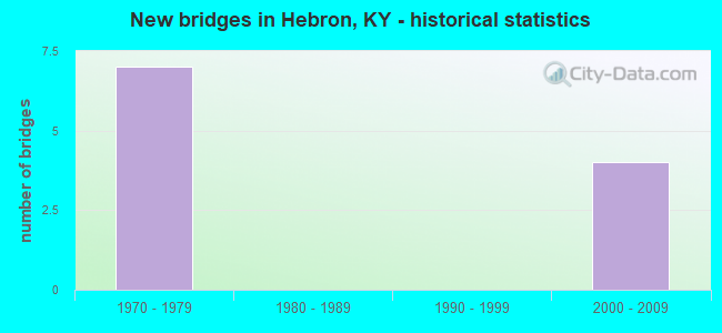
- New bridges - historical statistics
- 71970-1979
- 42000-2009


- Bridge Condition - Deck
- 75.0%Good
- 25.0%Satisfactory

- Bridge Condition - Substructure
- 50.0%Good
- 50.0%Satisfactory
Find on map >> Show street view
Structure Number: 8B00050L, Location: 1 MI W OF JCT KY 20 (Lat: 39.081111, Lng: -84.709444), Route carried "on" structure: State highway 237, Year Built: 1976, Status: Open, Structure Length: 6.46m (21.19ft), Average Daily Traffic: 7,300 (year 2019), Truck Traffic: 3%, Average Future Daily Traffic: 6,789 (year 2039), Design Load: HS 20+Mod, Features Intersected: I-275, Facility Carried by Structure: NORTH BEND RD NC
Minimum Vertical Clearance: 30+ m (98+ ft), Kilometerpoint: 16.993, Lanes on structure: 3, Lanes under structure: 6, Owner: State Highway Agency, Approaching Roadway Width: 7.3m (24.0ft), Skew: 1 degrees, Material/Design: Steel continuous, Design/Construction: Stringer/Multi-beam, Number Of Spans In Main Unit: 2, Length of Maximum Span: 35.1m (115.2ft), Curb or Sidewalk Widths: Left: 0.5m (1.6ft), Right: 0.5m (1.6ft), Curb-To-Curb Width: 14.6m (47.9ft), Out-to-Out Width: 15.8m (51.8ft)
Condition: Deck: Good, Superstructure: Good, Substructure: Satisfactory, Operating Rating: 69.1 metric tons, Method Used To Determine Operating Rating: Load Factor (LF), Inventory Rating: 41.4 metric tons, Method Used To Determine Inventory Rating: Load Factor (LF), Structural Evaluation: Equal to present minimum criteria, Deck Geometry: Somewhat better than minimum adequacy, Underclear: Better than present minimum criteria, Approach Roadway Alignment: Better than present minimum criteria, Designated Inspection Frequency: Every 24 months, Inspection Date: June 2021, Deck Structure Type: Concrete Cast-file-Place, Wearing Surface/Protective System: Wearing Surface: Monolithic Concrete
Find on map >> Show street view
Structure Number: 8B00050R, Location: 1 MI N OF JCT KY 20 (Lat: 39.081111, Lng: -84.709167), Route carried "on" structure: State highway 237, Year Built: 1976, Status: Open, Structure Length: 6.46m (21.19ft), Average Daily Traffic: 7,300 (year 2019), Truck Traffic: 3%, Average Future Daily Traffic: 6,789 (year 2039), Design Load: HS 20+Mod, Features Intersected: I 275
Minimum Vertical Clearance: 30+ m (98+ ft), Kilometerpoint: 17.000, Lanes on structure: 2, Lanes under structure: 6, Owner: State Highway Agency, Approaching Roadway Width: 7.3m (24.0ft), Skew: 1 degrees, Material/Design: Steel continuous, Design/Construction: Stringer/Multi-beam, Number Of Spans In Main Unit: 2, Length of Maximum Span: 35.4m (116.1ft), Curb or Sidewalk Widths: Left: 0.5m (1.6ft), Right: 0.5m (1.6ft), Curb-To-Curb Width: 11.0m (36.1ft), Out-to-Out Width: 12.1m (39.7ft)
Condition: Deck: Good, Superstructure: Good, Substructure: Satisfactory, Operating Rating: 69.1 metric tons, Method Used To Determine Operating Rating: Load Factor (LF), Inventory Rating: 41.4 metric tons, Method Used To Determine Inventory Rating: Load Factor (LF), Structural Evaluation: Equal to present minimum criteria, Deck Geometry: Equal to present minimum criteria, Underclear: Equal to present minimum criteria, Approach Roadway Alignment: Equal to present minimum criteria, Designated Inspection Frequency: Every 24 months, Inspection Date: June 2021, Deck Structure Type: Concrete Cast-file-Place, Wearing Surface/Protective System: Wearing Surface: Monolithic Concrete
Find on map >> Show street view
Structure Number: 8B00057N, Location: .20 MI WEST OF KY 20 OP (Lat: 39.074722, Lng: -84.676667), Route carried "on" structure: Interstate 275, Year Built: 1971, Status: Open, Structure Length: 1.16m (3.81ft), Average Daily Traffic: 49,942 (year 2020), Truck Traffic: 15%, Average Future Daily Traffic: 53,437 (year 2040), Design Load: HS 20, Features Intersected: ELIJAH CREEK
Minimum Vertical Clearance: 30+ m (98+ ft), Kilometerpoint: 8.332, Lanes on structure: 6, Base Highway Network: Yes, Owner: State Highway Agency, Approaching Roadway Width: 31.7m (104.0ft), Material/Design: Concrete, Design/Construction: Culvert, Number Of Spans In Main Unit: 2, Length of Maximum Span: 5.2m (17.1ft)
Condition: Channel: Satisfactory, Culverts: Satisfactory, Operating Rating: 99.8 metric tons, Method Used To Determine Operating Rating: Load Factor (LF), Inventory Rating: 99.8 metric tons, Method Used To Determine Inventory Rating: Load Factor (LF), Structural Evaluation: Equal to present minimum criteria, Waterway Adequacy: Meets minimum limits, Approach Roadway Alignment: Equal to present desirable criteria, Designated Inspection Frequency: Every 24 months, Inspection Date: June 2021
Find on map >> Show street view
Structure Number: 8B00087L, Location: 1 MI.NE. HEBRON,KY (Lat: 39.077778, Lng: -84.689444), Route carried "on" structure: Interstate 275, Year Built: 2000, Status: Open, Structure Length: 3.60m (11.81ft), Average Daily Traffic: 24,971 (year 2020), Truck Traffic: 15%, Average Future Daily Traffic: 26,719 (year 2040), Design Load: HS 25 or greater, Features Intersected: ELIJAH CREEK ROAD
Minimum Vertical Clearance: 30+ m (98+ ft), Kilometerpoint: 9.508, Lanes on structure: 3, Lanes under structure: 2, Base Highway Network: Yes, Owner: State Highway Agency, Approaching Roadway Width: 17.1m (56.1ft), Material/Design: Prestressed concrete, Design/Construction: Stringer/Multi-beam, Number Of Spans In Main Unit: 3, Length of Maximum Span: 16.8m (55.1ft), Curb or Sidewalk Widths: Left: 0.5m (1.6ft), Right: 0.5m (1.6ft), Curb-To-Curb Width: 17.1m (56.1ft), Out-to-Out Width: 18.1m (59.4ft)
Condition: Deck: Satisfactory, Superstructure: Good, Substructure: Good, Operating Rating: 76.6 metric tons, Method Used To Determine Operating Rating: Load Factor (LF), Inventory Rating: 45.9 metric tons, Method Used To Determine Inventory Rating: Load Factor (LF), Structural Evaluation: Better than present minimum criteria, Deck Geometry: Equal to present minimum criteria, Underclear: Superior to present desirable criteria, Approach Roadway Alignment: Superior to present desirable criteria, Designated Inspection Frequency: Every 24 months, Inspection Date: June 2021, Deck Structure Type: Concrete Cast-file-Place, Wearing Surface/Protective System: Wearing Surface: Monolithic Concrete, Deck Protection: Epoxy Coated Reinforcing
Find on map >> Show street view
Structure Number: 8B00087R, Location: 1 MI.NE. HEBRON,KY (Lat: 39.077500, Lng: -84.689444), Route carried "on" structure: Interstate 275, Year Built: 2000, Status: Open, Structure Length: 3.60m (11.81ft), Average Daily Traffic: 24,971 (year 2020), Truck Traffic: 15%, Average Future Daily Traffic: 26,719 (year 2040), Design Load: HS 25 or greater, Features Intersected: ELIJAH CREEK ROAD
Minimum Vertical Clearance: 30+ m (98+ ft), Kilometerpoint: 9.522, Lanes on structure: 3, Lanes under structure: 2, Base Highway Network: Yes, Owner: State Highway Agency, Approaching Roadway Width: 17.1m (56.1ft), Material/Design: Prestressed concrete, Design/Construction: Stringer/Multi-beam, Number Of Spans In Main Unit: 3, Length of Maximum Span: 16.8m (55.1ft), Curb or Sidewalk Widths: Left: 0.5m (1.6ft), Right: 0.5m (1.6ft), Curb-To-Curb Width: 17.1m (56.1ft), Out-to-Out Width: 18.1m (59.4ft)
Condition: Deck: Good, Superstructure: Good, Substructure: Good, Operating Rating: 76.6 metric tons, Method Used To Determine Operating Rating: Load Factor (LF), Inventory Rating: 45.9 metric tons, Method Used To Determine Inventory Rating: Load Factor (LF), Structural Evaluation: Better than present minimum criteria, Deck Geometry: Equal to present minimum criteria, Underclear: Better than present minimum criteria, Approach Roadway Alignment: Superior to present desirable criteria, Designated Inspection Frequency: Every 24 months, Inspection Date: June 2021, Deck Structure Type: Concrete Cast-file-Place, Wearing Surface/Protective System: Wearing Surface: Monolithic Concrete, Deck Protection: Epoxy Coated Reinforcing
Find on map >> Show street view
Structure Number: 8B00050L, Location: 1 MI W OF JCT KY 20 (Lat: 39.081111, Lng: -84.709444), Route carried "under" structure: Interstate 275, Year Built: 1976, Structure Length: 0. m, Average Daily Traffic: 49,942 (year 2020), Truck Traffic: 15%, Features Intersected: I-275, Facility Carried by Structure: NORTH BEND RD NC
Minimum Vertical Clearance: 5.21m (17.09ft), Kilometerpoint: 11.317, Lanes on structure: 3, Lanes under structure: 5, Material/Design: Steel continuous, Design/Construction: Stringer/Multi-beam, Length of Maximum Span: 35.1m (115.2ft)
Find on map >> Show street view
Structure Number: 8B00050L, Location: 1 MI W OF JCT KY 20 (Lat: 39.081111, Lng: -84.709444), Route carried "under" structure: Ramp Interstate 275, Year Built: 1976, Structure Length: 0. m, Average Daily Traffic: 49,942 (year 2020), Truck Traffic: 15%, Features Intersected: I-275, Facility Carried by Structure: NORTH BEND RD NC
Minimum Vertical Clearance: 5.21m (17.09ft), Kilometerpoint: 11.320, Lanes on structure: 3, Lanes under structure: 1, Material/Design: Steel continuous, Design/Construction: Stringer/Multi-beam, Length of Maximum Span: 35.1m (115.2ft)
Find on map >> Show street view
Structure Number: 8B00050R, Location: 1 MI N OF JCT KY 20 (Lat: 39.081111, Lng: -84.709167), Route carried "under" structure: Ramp Interstate 275, Year Built: 1976, Structure Length: 0. m, Average Daily Traffic: 49,942 (year 2020), Truck Traffic: 15%, Features Intersected: I 275, Facility Carried by Structure: KY-237
Minimum Vertical Clearance: 30+ m (98+ ft), Kilometerpoint: 11.310, Lanes on structure: 2, Lanes under structure: 1, Material/Design: Steel continuous, Design/Construction: Stringer/Multi-beam, Length of Maximum Span: 35.4m (116.1ft)
Find on map >> Show street view
Structure Number: 8B00050R, Location: 1 MI N OF JCT KY 20 (Lat: 39.081111, Lng: -84.709167), Route carried "under" structure: Interstate 275, Year Built: 1976, Structure Length: 0. m, Average Daily Traffic: 49,942 (year 2020), Truck Traffic: 15%, Features Intersected: I 275, Facility Carried by Structure: KY-237
Minimum Vertical Clearance: 30+ m (98+ ft), Kilometerpoint: 11.310, Lanes on structure: 2, Lanes under structure: 5, Material/Design: Steel continuous, Design/Construction: Stringer/Multi-beam, Length of Maximum Span: 35.4m (116.1ft)
Find on map >> Show street view
Structure Number: 8B00087L, Location: 1 MI.NE. HEBRON,KY (Lat: 39.077778, Lng: -84.689444), Route carried "under" structure: County highway 1040, Year Built: 2000, Structure Length: 0. m, Average Daily Traffic: 58 (year 2006), Features Intersected: ELIJAH CREEK ROAD, Facility Carried by Structure: I-275 WB
Minimum Vertical Clearance: 30+ m (98+ ft), Kilometerpoint: 1.959, Lanes on structure: 3, Lanes under structure: 2, Material/Design: Prestressed concrete, Design/Construction: Stringer/Multi-beam, Length of Maximum Span: 16.8m (55.1ft)
Find on map >> Show street view
Structure Number: 8B00087R, Location: 1 MI.NE. HEBRON,KY (Lat: 39.077500, Lng: -84.689444), Route carried "under" structure: County highway 1040, Year Built: 2000, Structure Length: 0. m, Average Daily Traffic: 58 (year 2006), Features Intersected: ELIJAH CREEK ROAD, Facility Carried by Structure: I-275 EB
Minimum Vertical Clearance: 30+ m (98+ ft), Kilometerpoint: 1.988, Lanes on structure: 3, Lanes under structure: 2, Material/Design: Prestressed concrete, Design/Construction: Stringer/Multi-beam, Length of Maximum Span: 16.8m (55.1ft)