Bridge Statistics for Greenfield Town, Massachusetts (MA)
Condition, Traffic, Stress, Structural Evaluation, Project Costs
- National Bridge Inventory (NBI) Statistics
- 29Number of bridges
- 358ft / 109mTotal length
- $79,685,000Total costs
- 277,346Total average daily traffic
- 27,437Total average daily truck traffic
- 449,100Total future (year 2031) average daily traffic
- National Bridge Inventory (NBI) Registered Bridges for Greenfield Town
- No street view available for this location
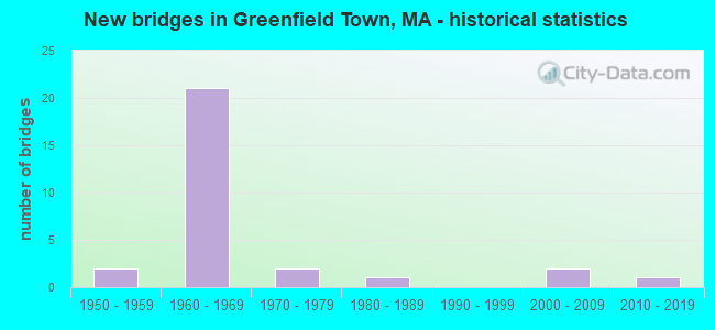
- New bridges - historical statistics
- 21950-1959
- 211960-1969
- 21970-1979
- 11980-1989
- 22000-2009
- 12010-2019

- Reconstructed bridges - Historical Statistics
- 91980-1989
- 01990-1999
- 22000-2009


- Bridge Condition - Deck
- 4.0%Excellent
- 48.0%Good
- 16.0%Satisfactory
- 28.0%Fair
- 4.0%Poor

- Bridge Condition - Superstructure
- 4.0%Excellent
- 8.0%Good
- 52.0%Satisfactory
- 32.0%Fair
- 4.0%Poor

- Bridge Condition - Substructure
- 4.0%Excellent
- 8.0%Very good
- 28.0%Good
- 40.0%Satisfactory
- 20.0%Fair

- Bridge Condition - Channel
- 11.1%Excellent
- 33.3%Good
- 33.3%Satisfactory
- 22.2%Fair

- Bridge Condition - Culverts
- 25.0%Good
- 50.0%Satisfactory
- 25.0%Fair
Find on map >> Show street view
Structure Number: G12006BWNMUNNBI, Location: 0.1 MI W OF LEYDEN RD (Lat: 42.605717, Lng: -72.613950), Route carried "on" structure: City street , Year Built: 2019, Status: Open, Structure Length: 3.33m (10.93ft), Average Daily Traffic: 5,560 (year 2019), Truck Traffic: 7%, Design Load: HL 93, Features Intersected: WATER GREEN RIVER, Facility Carried by Structure: HWY NASHS MLL RD
Minimum Vertical Clearance: 30+ m (98+ ft), Kilometerpoint: 0.676, Lanes on structure: 2, Owner: Town or Township Highway Agency, Approaching Roadway Width: 9.7m (31.8ft), Skew: 1 degrees, Material/Design: Steel, Design/Construction: Stringer/Multi-beam, Number Of Spans In Main Unit: 1, Length of Maximum Span: 32.0m (105.0ft), Curb or Sidewalk Widths: Left: 0.0m, Right: 1.7m (5.6ft), Curb-To-Curb Width: 8.5m (27.9ft), Out-to-Out Width: 11.0m (36.1ft)
Condition: Deck: Excellent, Superstructure: Excellent, Substructure: Excellent, Channel: Excellent, Operating Rating: 68.0 metric tons, Method Used To Determine Operating Rating: Load and Resistance Factor Rating (LRFR) rating reported by rating factor(RF) method using HL-93 loadings, Inventory Rating: 51.8 metric tons, Method Used To Determine Inventory Rating: Load and Resistance Factor Rating (LRFR) rating reported by rating factor(RF) method using HL-93 loadings, Structural Evaluation: Superior to present desirable criteria, Deck Geometry: High priority of replacement, Waterway Adequacy: Equal to present minimum criteria, Approach Roadway Alignment: Equal to present minimum criteria, Designated Inspection Frequency: Every 24 months, Inspection Date: December 2021, Deck Structure Type: Concrete Cast-file-Place, Wearing Surface/Protective System: Wearing Surface: Bituminous, Membrane: Epoxy, Deck Protection: Epoxy Coated Reinforcing
Find on map >> Show street view
Structure Number: G120100Q8MUNNBI, Location: E OF RVR RD @ LEYDEN BRDR (Lat: 42.646597, Lng: -72.620108), Route carried "on" structure: City street , Year Built: 1972, Year Reconstructed: 2013, Status: Posted for load, Structure Length: 2.85m (9.35ft), Average Daily Traffic: 640 (year 2012), Average Future Daily Traffic: 790 (year 2032), Design Load: H 20, Features Intersected: WATER GREEN RIVER, Facility Carried by Structure: HWY EUNICE WLLMS
Minimum Vertical Clearance: 3.47m (11.38ft), Kilometerpoint: 0.451, Lanes on structure: 1, Owner: Town or Township Highway Agency, Approaching Roadway Width: 4.9m (16.1ft), Material/Design: Wood or Timber, Design/Construction: Truss - Thru, Number Of Spans In Main Unit: 1, Length of Maximum Span: 27.8m (91.2ft), Curb or Sidewalk Widths: Left: 0.2m (0.7ft), Right: 0.2m (0.7ft), Curb-To-Curb Width: 3.4m (11.2ft), Out-to-Out Width: 4.0m (13.1ft)
Condition: Deck: Good, Superstructure: Satisfactory, Substructure: Very good, Channel: Good, Operating Rating: 42.5 metric tons, Method Used To Determine Operating Rating: Allowable Stress (AS), Inventory Rating: 31.9 metric tons, Method Used To Determine Inventory Rating: Allowable Stress (AS), Structural Evaluation: Equal to present minimum criteria, Deck Geometry: High priority of replacement, Waterway Adequacy: Better than present minimum criteria, Approach Roadway Alignment: Better than present minimum criteria, Length Of Structure Improvement: 3.80m (12.47ft), Designated Inspection Frequency: Every 24 months, Critical Feature Inspection Frequency: Every 24 months, Inspection Date: November 2020, Critical Feature Inspection Date: November 2020, Bridge Improvement Cost: $2,548,000, Roadway Improvement Cost: $255,000, Total Project Cost: $3,823,000 ( Estimate for 2022), Deck Structure Type: Wood or Timber, Wearing Surface/Protective System: Wearing Surface: Wood or Timber
Find on map >> Show street view
Structure Number: G120170QAMUNNBI, Location: 0.5 MI N OF PLAIN RD (Lat: 42.611978, Lng: -72.632931), Route carried "on" structure: City street , Year Built: 1989, Status: Open, Structure Length: 0.73m (2.40ft), Average Daily Traffic: 1,940 (year 2019), Truck Traffic: 7%, Average Future Daily Traffic: 816 (year 2032), Design Load: HS 20, Features Intersected: WATER ALLEN BROOK, Facility Carried by Structure: HWY COLRAIN RD
Minimum Vertical Clearance: 30+ m (98+ ft), Kilometerpoint: 3.380, Lanes on structure: 2, Owner: Town or Township Highway Agency, Approaching Roadway Width: 12.2m (40.0ft), Skew: 2 degrees, Material/Design: Concrete, Design/Construction: Culvert, Number Of Spans In Main Unit: 2, Length of Maximum Span: 3.4m (11.2ft), Curb-To-Curb Width: 12.2m (40.0ft), Out-to-Out Width: 17.1m (56.1ft)
Condition: Channel: Satisfactory, Culverts: Satisfactory, Operating Rating: 71.0 metric tons, Method Used To Determine Operating Rating: Allowable Stress (AS), Inventory Rating: 34.1 metric tons, Method Used To Determine Inventory Rating: Allowable Stress (AS), Structural Evaluation: Equal to present minimum criteria, Deck Geometry: Better than present minimum criteria, Waterway Adequacy: Equal to present desirable criteria, Approach Roadway Alignment: Better than present minimum criteria, Length Of Structure Improvement: 0.20m (0.66ft), Designated Inspection Frequency: Every 24 months, Inspection Date: March 2021, Bridge Improvement Cost: $125,000, Roadway Improvement Cost: $13,000, Total Project Cost: $188,000 ( Estimate for 2022)
Find on map >> Show street view
Structure Number: G12018ANUMUNNBI, Location: 425' N OF COLRAIN RD (Lat: 42.622792, Lng: -72.635517), Route carried "on" structure: City street , Year Built: 2001, Status: Open, Structure Length: 1.20m (3.94ft), Average Daily Traffic: 1,164 (year 2015), Truck Traffic: 6%, Average Future Daily Traffic: 1,633 (year 2032), Design Load: HS 20, Features Intersected: WATER HINSDALE BROOK, Facility Carried by Structure: HWY GREEN RIV RD
Minimum Vertical Clearance: 30+ m (98+ ft), Kilometerpoint: 0.145, Lanes on structure: 2, Owner: Town or Township Highway Agency, Approaching Roadway Width: 6.0m (19.7ft), Skew: 1 degrees, Material/Design: Prestressed concrete, Design/Construction: Slab, Number Of Spans In Main Unit: 1, Length of Maximum Span: 11.5m (37.7ft), Curb or Sidewalk Widths: Left: 0.0m, Right: 1.6m (5.2ft), Curb-To-Curb Width: 6.0m (19.7ft), Out-to-Out Width: 8.3m (27.2ft)
Condition: Deck: Good, Superstructure: Good, Substructure: Very good, Channel: Good, Operating Rating: 71.5 metric tons, Method Used To Determine Operating Rating: Load Factor (LF), Inventory Rating: 42.8 metric tons, Method Used To Determine Inventory Rating: Load Factor (LF), Structural Evaluation: Better than present minimum criteria, Deck Geometry: High priority of replacement, Waterway Adequacy: Equal to present desirable criteria, Approach Roadway Alignment: Equal to present minimum criteria, Length Of Structure Improvement: 1.30m (4.27ft), Designated Inspection Frequency: Every 24 months, Inspection Date: June 2021, Bridge Improvement Cost: $908,000, Roadway Improvement Cost: $91,000, Total Project Cost: $1,363,000 ( Estimate for 2022), Deck Structure Type: Concrete Precast Panels, Wearing Surface/Protective System: Wearing Surface: Bituminous, Membrane: Preformed Fabric, Deck Protection: Epoxy Coated Reinforcing
Find on map >> Show street view
Structure Number: G12019145DOT634, Location: 0.1 M W INT MUNSON ST (Lat: 42.572131, Lng: -72.622111), Route carried "on" structure: City street , Year Built: 1971, Status: Open, Structure Length: 2.89m (9.48ft), Average Daily Traffic: 1,300 (year 2020), Truck Traffic: 6%, Average Future Daily Traffic: 1,226 (year 2031), Design Load: H 20, Features Intersected: RR BMRR, Facility Carried by Structure: HWY WISDOM WAY
Minimum Vertical Clearance: 30+ m (98+ ft), Kilometerpoint: 0.000, Lanes on structure: 2, Owner: State Highway Agency, Approaching Roadway Width: 9.8m (32.2ft), Skew: 2 degrees, Material/Design: Steel, Design/Construction: Stringer/Multi-beam, Number Of Spans In Main Unit: 1, Length of Maximum Span: 27.2m (89.2ft), Curb or Sidewalk Widths: Left: 1.5m (4.9ft), Right: 0.5m (1.6ft), Curb-To-Curb Width: 9.8m (32.2ft), Out-to-Out Width: 12.6m (41.3ft)
Condition: Deck: Good, Superstructure: Satisfactory, Substructure: Good, Operating Rating: 52.3 metric tons, Method Used To Determine Operating Rating: Allowable Stress (AS), Inventory Rating: 27.7 metric tons, Method Used To Determine Inventory Rating: Allowable Stress (AS), Structural Evaluation: Equal to present minimum criteria, Deck Geometry: Somewhat better than minimum adequacy, Underclear: Meets minimum limits, Approach Roadway Alignment: Equal to present desirable criteria, Length Of Structure Improvement: 2.90m (9.51ft), Designated Inspection Frequency: Every 24 months, Inspection Date: March 2020, Bridge Improvement Cost: $1,436,000, Roadway Improvement Cost: $144,000, Total Project Cost: $2,155,000 ( Estimate for 2022), Deck Structure Type: Concrete Cast-file-Place, Wearing Surface/Protective System: Wearing Surface: Bituminous, Membrane: Built-up
Find on map >> Show street view
Structure Number: G12022144DOT634, Location: JCT SEVERANCE ST (Lat: 42.641628, Lng: -72.576856), Route carried "on" structure: City street , Year Built: 1956, Status: Open, Structure Length: 2.99m (9.81ft), Average Daily Traffic: 1,163 (year 2018), Truck Traffic: 4%, Average Future Daily Traffic: 4,493 (year 2033), Design Load: H 15, Features Intersected: RR BMRR, Facility Carried by Structure: HWY W LOG PLAIN
Minimum Vertical Clearance: 30+ m (98+ ft), Kilometerpoint: 0.000, Lanes on structure: 2, Owner: State Highway Agency, Approaching Roadway Width: 9.1m (29.9ft), Material/Design: Steel continuous, Design/Construction: Stringer/Multi-beam, Number Of Spans In Main Unit: 3, Length of Maximum Span: 18.3m (60.0ft), Curb or Sidewalk Widths: Left: 1.5m (4.9ft), Right: 0.3m (1.0ft), Curb-To-Curb Width: 9.1m (29.9ft), Out-to-Out Width: 11.8m (38.7ft)
Condition: Deck: Fair, Superstructure: Satisfactory, Substructure: Satisfactory, Operating Rating: 47.1 metric tons, Method Used To Determine Operating Rating: Allowable Stress (AS), Inventory Rating: 28.4 metric tons, Method Used To Determine Inventory Rating: Allowable Stress (AS), Structural Evaluation: Equal to present minimum criteria, Deck Geometry: Somewhat better than minimum adequacy, Underclear: High priority of corrective action, Approach Roadway Alignment: Equal to present desirable criteria, Length Of Structure Improvement: 3.00m (9.84ft), Designated Inspection Frequency: Every 24 months, Inspection Date: Febuary 2020, Bridge Improvement Cost: $1,391,000, Roadway Improvement Cost: $140,000, Total Project Cost: $2,087,000 ( Estimate for 2022), Deck Structure Type: Concrete Cast-file-Place, Wearing Surface/Protective System: Wearing Surface: Integral Concrete
Find on map >> Show street view
Structure Number: G120350UHDOTNBI, Location: .2 M W HOME DEPOT PLAZA (Lat: 42.589344, Lng: -72.630883), Route carried "on" structure: State highway 2, Year Built: 1951, Status: Temporarily open, Structure Length: 4.28m (14.04ft), Average Daily Traffic: 12,901 (year 2019), Truck Traffic: 10%, Average Future Daily Traffic: 13,274 (year 2031), Design Load: H 20, Features Intersected: HWY OLD SHELBURNE RD
Minimum Vertical Clearance: 30+ m (98+ ft), Kilometerpoint: 75.441, Lanes on structure: 2, Lanes under structure: 2, Base Highway Network: Yes, Owner: State Highway Agency, Approaching Roadway Width: 12.6m (41.3ft), Skew: 2 degrees, Material/Design: Steel continuous, Design/Construction: Stringer/Multi-beam, Number Of Spans In Main Unit: 3, Length of Maximum Span: 15.3m (50.2ft), Curb or Sidewalk Widths: Left: 0.5m (1.6ft), Right: 0.5m (1.6ft), Curb-To-Curb Width: 12.6m (41.3ft), Out-to-Out Width: 14.2m (46.6ft)
Condition: Deck: Fair, Superstructure: Fair, Substructure: Fair, Operating Rating: 45.3 metric tons, Method Used To Determine Operating Rating: Load Factor (LF), Inventory Rating: 27.1 metric tons, Method Used To Determine Inventory Rating: Load Factor (LF), Structural Evaluation: Somewhat better than minimum adequacy, Deck Geometry: Somewhat better than minimum adequacy, Underclear: Meets minimum limits, Approach Roadway Alignment: Equal to present desirable criteria, Length Of Structure Improvement: 4.30m (14.11ft), Designated Inspection Frequency: Every 24 months, Inspection Date: October 2020, Bridge Improvement Cost: $2,399,000, Roadway Improvement Cost: $240,000, Total Project Cost: $3,599,000 ( Estimate for 2022), Deck Structure Type: Concrete Cast-file-Place, Wearing Surface/Protective System: Wearing Surface: Bituminous, Membrane: Built-up
Find on map >> Show street view
Structure Number: G12041AHNMUNNBI, Location: .1 M S EUNICE WLLMS DR (Lat: 42.643317, Lng: -72.610103), Route carried "on" structure: City street , Year Built: 1960, Status: Open, Structure Length: 0.77m (2.53ft), Average Daily Traffic: 2,457 (year 2014), Truck Traffic: 5%, Average Future Daily Traffic: 5,717 (year 2031), Design Load: H 20, Features Intersected: WATER GLEN BROOK, Facility Carried by Structure: HWY LEYDEN RD
Minimum Vertical Clearance: 30+ m (98+ ft), Kilometerpoint: 0.000, Lanes on structure: 2, Base Highway Network: Yes, Owner: Town or Township Highway Agency, Approaching Roadway Width: 9.8m (32.2ft), Skew: 1 degrees, Material/Design: Steel, Design/Construction: Culvert, Number Of Spans In Main Unit: 1, Length of Maximum Span: 7.7m (25.3ft)
Condition: Channel: Fair, Culverts: Good, Inventory Rating: 67.8 metric tons, Method Used To Determine Inventory Rating: Load Factor (LF), Structural Evaluation: Better than present minimum criteria, Waterway Adequacy: Superior to present desirable criteria, Approach Roadway Alignment: Equal to present desirable criteria, Length Of Structure Improvement: 0.40m (1.31ft), Designated Inspection Frequency: Every 24 months, Inspection Date: November 2020, Bridge Improvement Cost: $275,000, Roadway Improvement Cost: $28,000, Total Project Cost: $413,000 ( Estimate for 2022), Wearing Surface/Protective System: Wearing Surface: Bituminous
Find on map >> Show street view
Structure Number: G120420XYDOTNBI, Location: MM 48.4 ON I-91 NB (Lat: 42.647811, Lng: -72.562603), Route carried "on" structure: Interstate 91, Year Built: 1965, Year Reconstructed: 1986, Status: Open, Structure Length: 4.31m (14.14ft), Average Daily Traffic: 9,871 (year 2016), Truck Traffic: 12%, Average Future Daily Traffic: 15,398 (year 2031), Design Load: HS 20+Mod, Features Intersected: US 5 /ST10/BRNRDSTN RD
Minimum Vertical Clearance: 30+ m (98+ ft), Kilometerpoint: 77.996, Lanes on structure: 2, Lanes under structure: 2, Base Highway Network: Yes, Owner: State Highway Agency, Approaching Roadway Width: 11.6m (38.1ft), Skew: 3 degrees, Material/Design: Steel, Design/Construction: Stringer/Multi-beam, Number Of Spans In Main Unit: 3, Length of Maximum Span: 20.1m (65.9ft), Curb-To-Curb Width: 12.6m (41.3ft), Out-to-Out Width: 13.6m (44.6ft)
Condition: Deck: Good, Superstructure: Satisfactory, Substructure: Satisfactory, Operating Rating: 69.7 metric tons, Method Used To Determine Operating Rating: Load Factor (LF), Inventory Rating: 41.8 metric tons, Method Used To Determine Inventory Rating: Load Factor (LF), Structural Evaluation: Equal to present minimum criteria, Deck Geometry: Better than present minimum criteria, Underclear: Equal to present minimum criteria, Approach Roadway Alignment: Equal to present desirable criteria, Length Of Structure Improvement: 4.40m (14.44ft), Designated Inspection Frequency: Every 24 months, Inspection Date: October 2020, Bridge Improvement Cost: $83,000, Roadway Improvement Cost: $9,000, Total Project Cost: $125,000 ( Estimate for 2022), Deck Structure Type: Concrete Cast-file-Place, Wearing Surface/Protective System: Wearing Surface: Bituminous, Membrane: Built-up, Deck Protection: Epoxy Coated Reinforcing
Find on map >> Show street view
Structure Number: G120420Y0DOTNBI, Location: MM 48.4 ON I-91 SB (Lat: 42.648261, Lng: -72.562714), Route carried "on" structure: Interstate 91, Year Built: 1965, Year Reconstructed: 1986, Status: Open, Structure Length: 4.31m (14.14ft), Average Daily Traffic: 10,956 (year 2016), Truck Traffic: 12%, Average Future Daily Traffic: 14,135 (year 2031), Design Load: HS 20+Mod, Features Intersected: US 5 /ST10/BRNRDSTN RD
Minimum Vertical Clearance: 30+ m (98+ ft), Kilometerpoint: 77.996, Lanes on structure: 2, Lanes under structure: 2, Base Highway Network: Yes, Owner: State Highway Agency, Approaching Roadway Width: 12.6m (41.3ft), Skew: 3 degrees, Material/Design: Steel, Design/Construction: Stringer/Multi-beam, Number Of Spans In Main Unit: 3, Length of Maximum Span: 20.1m (65.9ft), Curb-To-Curb Width: 12.6m (41.3ft), Out-to-Out Width: 13.6m (44.6ft)
Condition: Deck: Satisfactory, Superstructure: Fair, Substructure: Good, Operating Rating: 69.7 metric tons, Method Used To Determine Operating Rating: Load Factor (LF), Inventory Rating: 41.8 metric tons, Method Used To Determine Inventory Rating: Load Factor (LF), Structural Evaluation: Somewhat better than minimum adequacy, Deck Geometry: Better than present minimum criteria, Underclear: Better than present minimum criteria, Approach Roadway Alignment: Equal to present desirable criteria, Length Of Structure Improvement: 4.40m (14.44ft), Designated Inspection Frequency: Every 24 months, Inspection Date: October 2020, Bridge Improvement Cost: $2,351,000, Roadway Improvement Cost: $236,000, Total Project Cost: $3,527,000 ( Estimate for 2022), Deck Structure Type: Concrete Cast-file-Place, Wearing Surface/Protective System: Wearing Surface: Bituminous, Membrane: Built-up, Deck Protection: Epoxy Coated Reinforcing
Find on map >> Show street view
Structure Number: G120430XWDOTNBI, Location: MM 47.6 ON I-91 NB (Lat: 42.639100, Lng: -72.572517), Route carried "on" structure: Interstate 91, Year Built: 1961, Year Reconstructed: 1986, Status: Open, Structure Length: 3.21m (10.53ft), Average Daily Traffic: 9,515 (year 2018), Truck Traffic: 8%, Average Future Daily Traffic: 26,881 (year 2032), Design Load: HS 20+Mod, Features Intersected: HWY SEVERANCE ST
Minimum Vertical Clearance: 30+ m (98+ ft), Kilometerpoint: 76.715, Lanes on structure: 2, Lanes under structure: 2, Base Highway Network: Yes, Owner: State Highway Agency, Approaching Roadway Width: 11.6m (38.1ft), Material/Design: Steel, Design/Construction: Stringer/Multi-beam, Number Of Spans In Main Unit: 3, Length of Maximum Span: 12.8m (42.0ft), Curb-To-Curb Width: 12.6m (41.3ft), Out-to-Out Width: 13.6m (44.6ft)
Condition: Deck: Good, Superstructure: Satisfactory, Substructure: Satisfactory, Operating Rating: 72.3 metric tons, Method Used To Determine Operating Rating: Load Factor (LF), Inventory Rating: 43.4 metric tons, Method Used To Determine Inventory Rating: Load Factor (LF), Structural Evaluation: Equal to present minimum criteria, Deck Geometry: Better than present minimum criteria, Underclear: High priority of corrective action, Approach Roadway Alignment: Equal to present desirable criteria, Length Of Structure Improvement: 3.30m (10.83ft), Designated Inspection Frequency: Every 24 months, Inspection Date: December 2021, Bridge Improvement Cost: $63,000, Roadway Improvement Cost: $7,000, Total Project Cost: $95,000 ( Estimate for 2022), Deck Structure Type: Concrete Cast-file-Place, Wearing Surface/Protective System: Wearing Surface: Bituminous, Membrane: Built-up, Deck Protection: Epoxy Coated Reinforcing
Find on map >> Show street view
Structure Number: G120430XXDOTNBI, Location: MM 47.6 ON I-91 SB (Lat: 42.639342, Lng: -72.572892), Route carried "on" structure: Interstate 91, Year Built: 1961, Year Reconstructed: 1986, Status: Open, Structure Length: 3.04m (9.97ft), Average Daily Traffic: 10,562 (year 2018), Truck Traffic: 8%, Average Future Daily Traffic: 19,346 (year 2032), Design Load: HS 20+Mod, Features Intersected: HWY SEVERANCE ST
Minimum Vertical Clearance: 30+ m (98+ ft), Kilometerpoint: 76.715, Lanes on structure: 2, Lanes under structure: 2, Base Highway Network: Yes, Owner: State Highway Agency, Approaching Roadway Width: 11.6m (38.1ft), Material/Design: Steel, Design/Construction: Stringer/Multi-beam, Number Of Spans In Main Unit: 3, Length of Maximum Span: 12.8m (42.0ft), Curb-To-Curb Width: 12.6m (41.3ft), Out-to-Out Width: 13.6m (44.6ft)
Condition: Deck: Good, Superstructure: Satisfactory, Substructure: Fair, Operating Rating: 88.5 metric tons, Method Used To Determine Operating Rating: Load Factor (LF), Inventory Rating: 53.1 metric tons, Method Used To Determine Inventory Rating: Load Factor (LF), Structural Evaluation: Somewhat better than minimum adequacy, Deck Geometry: Better than present minimum criteria, Underclear: High priority of corrective action, Approach Roadway Alignment: Equal to present desirable criteria, Length Of Structure Improvement: 3.10m (10.17ft), Designated Inspection Frequency: Every 24 months, Inspection Date: December 2021, Bridge Improvement Cost: $1,657,000, Roadway Improvement Cost: $166,000, Total Project Cost: $2,486,000 ( Estimate for 2022), Deck Structure Type: Concrete Cast-file-Place, Wearing Surface/Protective System: Wearing Surface: Bituminous, Membrane: Built-up, Deck Protection: Epoxy Coated Reinforcing
Find on map >> Show street view
Structure Number: G12044155DOTNBI, Location: MM 45.8 ON I-91 NB (Lat: 42.616939, Lng: -72.592161), Route carried "on" structure: State highway 2, Year Built: 1965, Year Reconstructed: 1992, Status: Open, Structure Length: 5.32m (17.45ft), Average Daily Traffic: 2,974 (year 2020), Truck Traffic: 17%, Average Future Daily Traffic: 2,961 (year 2033), Design Load: HS 20+Mod, Features Intersected: I 91 NB
Minimum Vertical Clearance: 30+ m (98+ ft), Kilometerpoint: 80.747, Lanes on structure: 1, Lanes under structure: 2, Base Highway Network: Yes, Owner: State Highway Agency, Approaching Roadway Width: 7.6m (24.9ft), Skew: 3 degrees, Material/Design: Steel, Design/Construction: Stringer/Multi-beam, Number Of Spans In Main Unit: 3, Length of Maximum Span: 25.1m (82.3ft), Curb-To-Curb Width: 7.6m (24.9ft), Out-to-Out Width: 8.6m (28.2ft)
Condition: Deck: Good, Superstructure: Satisfactory, Substructure: Fair, Operating Rating: 59.3 metric tons, Method Used To Determine Operating Rating: Load Factor (LF), Inventory Rating: 35.5 metric tons, Method Used To Determine Inventory Rating: Load Factor (LF), Structural Evaluation: Somewhat better than minimum adequacy, Deck Geometry: High priority of replacement, Underclear: High priority of corrective action, Approach Roadway Alignment: Equal to present desirable criteria, Length Of Structure Improvement: 5.40m (17.72ft), Designated Inspection Frequency: Every 24 months, Inspection Date: January 2022, Bridge Improvement Cost: $1,825,000, Roadway Improvement Cost: $183,000, Total Project Cost: $2,738,000 ( Estimate for 2022), Deck Structure Type: Concrete Cast-file-Place, Wearing Surface/Protective System: Wearing Surface: Bituminous, Membrane: Preformed Fabric, Deck Protection: Epoxy Coated Reinforcing
Find on map >> Show street view
Structure Number: G12045154DOTNBI, Location: .4 M W JCT US 5 & ST 10 (Lat: 42.615183, Lng: -72.591689), Route carried "on" structure: State highway 2, Year Built: 1964, Year Reconstructed: 1992, Status: Open, Structure Length: 4.76m (15.62ft), Average Daily Traffic: 1,955 (year 2019), Truck Traffic: 10%, Average Future Daily Traffic: 7,581 (year 2032), Design Load: HS 20+Mod, Features Intersected: ST 2 WB RAMP 5S2W
Minimum Vertical Clearance: 30+ m (98+ ft), Kilometerpoint: 0.000, Lanes on structure: 1, Lanes under structure: 1, Base Highway Network: Yes, Owner: State Highway Agency, Approaching Roadway Width: 6.7m (22.0ft), Skew: 5 degrees, Material/Design: Steel, Design/Construction: Stringer/Multi-beam, Number Of Spans In Main Unit: 3, Length of Maximum Span: 18.0m (59.1ft), Curb-To-Curb Width: 7.6m (24.9ft), Out-to-Out Width: 8.6m (28.2ft)
Condition: Deck: Good, Superstructure: Satisfactory, Substructure: Satisfactory, Operating Rating: 47.4 metric tons, Method Used To Determine Operating Rating: Load Factor (LF), Inventory Rating: 28.4 metric tons, Method Used To Determine Inventory Rating: Load Factor (LF), Structural Evaluation: Equal to present minimum criteria, Deck Geometry: Meets minimum limits, Underclear: Meets minimum limits, Approach Roadway Alignment: Equal to present desirable criteria, Length Of Structure Improvement: 4.80m (15.75ft), Designated Inspection Frequency: Every 24 months, Inspection Date: December 2021, Bridge Improvement Cost: $1,622,000, Roadway Improvement Cost: $163,000, Total Project Cost: $2,434,000 ( Estimate for 2022), Deck Structure Type: Concrete Cast-file-Place, Wearing Surface/Protective System: Wearing Surface: Bituminous, Membrane: Preformed Fabric, Deck Protection: Epoxy Coated Reinforcing
Find on map >> Show street view
Structure Number: G12046156DOTNBI, Location: MM 45.7 ON I-91 NB (Lat: 42.615667, Lng: -72.594114), Route carried "on" structure: State highway 2, Year Built: 1965, Year Reconstructed: 1992, Status: Open, Structure Length: 5.63m (18.47ft), Average Daily Traffic: 5,524 (year 2019), Truck Traffic: 4%, Average Future Daily Traffic: 11,845 (year 2032), Design Load: HS 20+Mod, Features Intersected: I 91 NB
Minimum Vertical Clearance: 30+ m (98+ ft), Kilometerpoint: 80.747, Lanes on structure: 1, Lanes under structure: 2, Base Highway Network: Yes, Owner: State Highway Agency, Approaching Roadway Width: 6.7m (22.0ft), Skew: 4 degrees, Material/Design: Steel, Design/Construction: Stringer/Multi-beam, Number Of Spans In Main Unit: 3, Length of Maximum Span: 27.7m (90.9ft), Curb-To-Curb Width: 7.6m (24.9ft), Out-to-Out Width: 8.6m (28.2ft)
Condition: Deck: Good, Superstructure: Fair, Substructure: Satisfactory, Operating Rating: 80.8 metric tons, Method Used To Determine Operating Rating: Load Factor (LF), Inventory Rating: 48.4 metric tons, Method Used To Determine Inventory Rating: Load Factor (LF), Structural Evaluation: Somewhat better than minimum adequacy, Deck Geometry: High priority of replacement, Underclear: High priority of corrective action, Approach Roadway Alignment: Equal to present desirable criteria, Length Of Structure Improvement: 5.70m (18.70ft), Designated Inspection Frequency: Every 24 months, Inspection Date: December 2021, Bridge Improvement Cost: $1,926,000, Roadway Improvement Cost: $193,000, Total Project Cost: $2,890,000 ( Estimate for 2022), Deck Structure Type: Concrete Cast-file-Place, Wearing Surface/Protective System: Wearing Surface: Bituminous, Membrane: Preformed Fabric, Deck Protection: Epoxy Coated Reinforcing
Find on map >> Show street view
Structure Number: G12047152DOTNBI, Location: .1M NE OF RT 5 AND CHERRY (Lat: 42.610447, Lng: -72.585208), Route carried "on" structure: State highway 2, Year Built: 1965, Status: Open, Structure Length: 3.39m (11.12ft), Average Daily Traffic: 5,018 (year 2015), Truck Traffic: 9%, Average Future Daily Traffic: 9,950 (year 2032), Design Load: H 20, Features Intersected: US 5 /ST10/BRNRDSTN RD
Minimum Vertical Clearance: 30+ m (98+ ft), Kilometerpoint: 81.712, Lanes on structure: 2, Lanes under structure: 2, Base Highway Network: Yes, Owner: State Highway Agency, Approaching Roadway Width: 11.6m (38.1ft), Material/Design: Steel, Design/Construction: Stringer/Multi-beam, Number Of Spans In Main Unit: 3, Length of Maximum Span: 16.3m (53.5ft), Curb or Sidewalk Widths: Left: 0.5m (1.6ft), Right: 0.5m (1.6ft), Curb-To-Curb Width: 11.6m (38.1ft), Out-to-Out Width: 13.5m (44.3ft)
Condition: Deck: Fair, Superstructure: Satisfactory, Substructure: Good, Operating Rating: 46.7 metric tons, Method Used To Determine Operating Rating: Load Factor (LF), Inventory Rating: 28.0 metric tons, Method Used To Determine Inventory Rating: Load Factor (LF), Structural Evaluation: Equal to present minimum criteria, Deck Geometry: Equal to present minimum criteria, Approach Roadway Alignment: Equal to present desirable criteria, Length Of Structure Improvement: 3.40m (11.15ft), Designated Inspection Frequency: Every 24 months, Inspection Date: August 2021, Bridge Improvement Cost: $1,803,000, Roadway Improvement Cost: $181,000, Total Project Cost: $2,705,000 ( Estimate for 2022), Deck Structure Type: Concrete Cast-file-Place, Wearing Surface/Protective System: Wearing Surface: Bituminous, Membrane: Built-up
Find on map >> Show street view
Structure Number: G12047153DOTNBI, Location: .1M SW OF RT 5 AND BURNHA (Lat: 42.610731, Lng: -72.584792), Route carried "on" structure: State highway 2, Year Built: 1964, Status: Open, Structure Length: 3.49m (11.45ft), Average Daily Traffic: 4,453 (year 2015), Truck Traffic: 9%, Average Future Daily Traffic: 9,950 (year 2032), Design Load: H 20, Features Intersected: US 5 /ST10/BRNRDSTN RD
Minimum Vertical Clearance: 30+ m (98+ ft), Kilometerpoint: 81.712, Lanes on structure: 2, Lanes under structure: 2, Base Highway Network: Yes, Owner: State Highway Agency, Approaching Roadway Width: 11.6m (38.1ft), Material/Design: Steel, Design/Construction: Stringer/Multi-beam, Number Of Spans In Main Unit: 3, Length of Maximum Span: 16.3m (53.5ft), Curb or Sidewalk Widths: Left: 0.5m (1.6ft), Right: 0.5m (1.6ft), Curb-To-Curb Width: 3.6m (11.8ft), Out-to-Out Width: 13.5m (44.3ft)
Condition: Deck: Fair, Superstructure: Satisfactory, Substructure: Satisfactory, Operating Rating: 47.7 metric tons, Method Used To Determine Operating Rating: Load Factor (LF), Inventory Rating: 28.6 metric tons, Method Used To Determine Inventory Rating: Load Factor (LF), Structural Evaluation: Equal to present minimum criteria, Deck Geometry: High priority of replacement, Approach Roadway Alignment: Equal to present desirable criteria, Length Of Structure Improvement: 3.50m (11.48ft), Designated Inspection Frequency: Every 24 months, Inspection Date: August 2021, Bridge Improvement Cost: $1,856,000, Roadway Improvement Cost: $186,000, Total Project Cost: $2,785,000 ( Estimate for 2022), Deck Structure Type: Concrete Cast-file-Place, Wearing Surface/Protective System: Wearing Surface: Bituminous, Membrane: Built-up
Find on map >> Show street view
Structure Number: G120490XNDOTNBI, Location: MM 44.2 ON I-91 SB (Lat: 42.602806, Lng: -72.615167), Route carried "on" structure: Interstate 91, Year Built: 1962, Year Reconstructed: 1986, Status: Open, Structure Length: 5.65m (18.54ft), Average Daily Traffic: 18,071 (year 2017), Truck Traffic: 12%, Average Future Daily Traffic: 34,745 (year 2031), Design Load: HS 20+Mod, Features Intersected: WATER GREEN RIVER
Minimum Vertical Clearance: 30+ m (98+ ft), Kilometerpoint: 71.260, Lanes on structure: 2, Base Highway Network: Yes, Owner: State Highway Agency, Approaching Roadway Width: 12.6m (41.3ft), Skew: 3 degrees, Material/Design: Steel, Design/Construction: Stringer/Multi-beam, Number Of Spans In Main Unit: 3, Length of Maximum Span: 25.3m (83.0ft), Curb-To-Curb Width: 12.6m (41.3ft), Out-to-Out Width: 13.6m (44.6ft)
Condition: Deck: Good, Superstructure: Satisfactory, Substructure: Fair, Channel: Satisfactory, Operating Rating: 76.1 metric tons, Method Used To Determine Operating Rating: Load Factor (LF), Inventory Rating: 45.6 metric tons, Method Used To Determine Inventory Rating: Load Factor (LF), Structural Evaluation: Somewhat better than minimum adequacy, Deck Geometry: Better than present minimum criteria, Waterway Adequacy: Equal to present desirable criteria, Approach Roadway Alignment: Equal to present desirable criteria, Length Of Structure Improvement: 5.70m (18.70ft), Designated Inspection Frequency: Every 24 months, Inspection Date: May 2020, Bridge Improvement Cost: $3,045,000, Roadway Improvement Cost: $305,000, Total Project Cost: $4,568,000 ( Estimate for 2022), Deck Structure Type: Concrete Cast-file-Place, Wearing Surface/Protective System: Wearing Surface: Bituminous, Membrane: Built-up, Deck Protection: Epoxy Coated Reinforcing
Find on map >> Show street view
Structure Number: G120500XPDOTNBI, Location: MM 44.6 ON I-91 (Lat: 42.606653, Lng: -72.612525), Route carried "on" structure: Interstate 91, Year Built: 1962, Status: Open, Structure Length: 0.87m (2.85ft), Average Daily Traffic: 36,983 (year 2016), Truck Traffic: 10%, Average Future Daily Traffic: 37,114 (year 2033), Design Load: HS 20+Mod, Features Intersected: WATER NASHS MILL BROOK
Minimum Vertical Clearance: 5.84m (19.16ft), Kilometerpoint: 71.855, Lanes on structure: 6, Base Highway Network: Yes, Owner: State Highway Agency, Approaching Roadway Width: 30.5m (100.1ft), Skew: 14 degrees, Material/Design: Concrete continuous, Design/Construction: Culvert, Number Of Spans In Main Unit: 2, Length of Maximum Span: 4.3m (14.1ft)
Condition: Channel: Good, Culverts: Satisfactory, Inventory Rating: 69.5 metric tons, Method Used To Determine Inventory Rating: Load Factor (LF), Structural Evaluation: Equal to present minimum criteria, Waterway Adequacy: Equal to present desirable criteria, Approach Roadway Alignment: Equal to present desirable criteria, Length Of Structure Improvement: 4.20m (13.78ft), Designated Inspection Frequency: Every 24 months, Inspection Date: November 2021, Bridge Improvement Cost: $210,000, Roadway Improvement Cost: $22,000, Total Project Cost: $316,000 ( Estimate for 2022)
Find on map >> Show street view
Structure Number: G1205112YDOTNBI, Location: MM 44.5 I-91 (Lat: 42.606861, Lng: -72.612056), Route carried "on" structure: City street , Year Built: 1962, Status: Open, Structure Length: 9.69m (31.79ft), Average Daily Traffic: 3,362 (year 2019), Truck Traffic: 10%, Average Future Daily Traffic: 9,190 (year 2032), Design Load: H 20, Features Intersected: I 91, Facility Carried by Structure: HWY LEYDEN RD
Minimum Vertical Clearance: 30+ m (98+ ft), Kilometerpoint: 0.000, Lanes on structure: 2, Lanes under structure: 4, Owner: State Highway Agency, Approaching Roadway Width: 12.2m (40.0ft), Skew: 4 degrees, Material/Design: Steel, Design/Construction: Stringer/Multi-beam, Number Of Spans In Main Unit: 4, Length of Maximum Span: 33.8m (110.9ft), Curb or Sidewalk Widths: Left: 1.5m (4.9ft), Right: 0.5m (1.6ft), Curb-To-Curb Width: 12.2m (40.0ft), Out-to-Out Width: 14.9m (48.9ft)
Condition: Deck: Satisfactory, Superstructure: Satisfactory, Substructure: Good, Operating Rating: 48.3 metric tons, Method Used To Determine Operating Rating: Load Factor (LF), Inventory Rating: 28.9 metric tons, Method Used To Determine Inventory Rating: Load Factor (LF), Structural Evaluation: Equal to present minimum criteria, Deck Geometry: Equal to present minimum criteria, Underclear: Better than present minimum criteria, Approach Roadway Alignment: Equal to present minimum criteria, Length Of Structure Improvement: 9.70m (31.82ft), Designated Inspection Frequency: Every 24 months, Inspection Date: November 2021, Bridge Improvement Cost: $5,678,000, Roadway Improvement Cost: $568,000, Total Project Cost: $8,518,000 ( Estimate for 2022), Deck Structure Type: Concrete Cast-file-Place, Wearing Surface/Protective System: Wearing Surface: Bituminous, Membrane: Built-up
Find on map >> Show street view
Structure Number: G120530XTDOTNBI, Location: MM 45.2 ON I91 SB (Lat: 42.612628, Lng: -72.602742), Route carried "on" structure: Interstate 91, Year Built: 1962, Status: Temporarily open, Structure Length: 6.60m (21.65ft), Average Daily Traffic: 18,071 (year 2017), Truck Traffic: 12%, Average Future Daily Traffic: 27,774 (year 2031), Design Load: HS 20+Mod, Features Intersected: RR PAN AM
Minimum Vertical Clearance: 30+ m (98+ ft), Kilometerpoint: 72.821, Lanes on structure: 2, Base Highway Network: Yes, Owner: State Highway Agency, Approaching Roadway Width: 11.6m (38.1ft), Skew: 5 degrees, Material/Design: Steel, Design/Construction: Stringer/Multi-beam, Number Of Spans In Main Unit: 3, Length of Maximum Span: 23.0m (75.5ft), Curb-To-Curb Width: 11.6m (38.1ft), Out-to-Out Width: 13.5m (44.3ft)
Condition: Deck: Poor, Superstructure: Poor, Substructure: Satisfactory, Operating Rating: 63.0 metric tons, Method Used To Determine Operating Rating: Load Factor (LF), Inventory Rating: 37.7 metric tons, Method Used To Determine Inventory Rating: Load Factor (LF), Structural Evaluation: Meets minimum limits, Deck Geometry: Equal to present minimum criteria, Underclear: Somewhat better than minimum adequacy, Approach Roadway Alignment: Equal to present desirable criteria, Length Of Structure Improvement: 6.70m (21.98ft), Designated Inspection Frequency: Every 12 months, Other Special Inspection Frequency: Every 12 months, Inspection Date: April 2020, Other Special Inspection Date: April 2021, Bridge Improvement Cost: $3,553,000, Roadway Improvement Cost: $356,000, Total Project Cost: $5,330,000 ( Estimate for 2022), Deck Structure Type: Concrete Cast-file-Place, Wearing Surface/Protective System: Wearing Surface: Bituminous, Membrane: Built-up
Find on map >> Show street view
Structure Number: G120540XUDOTNBI, Location: MM 45.4 ON I-91 NB (Lat: 42.613139, Lng: -72.599500), Route carried "on" structure: Interstate 91, Year Built: 1962, Status: Open, Structure Length: 4.86m (15.94ft), Average Daily Traffic: 12,109 (year 2018), Truck Traffic: 10%, Average Future Daily Traffic: 38,693 (year 2032), Design Load: HS 20+Mod, Features Intersected: HWY COUNTRY CLUB RD
Minimum Vertical Clearance: 30+ m (98+ ft), Kilometerpoint: 73.046, Lanes on structure: 2, Lanes under structure: 2, Base Highway Network: Yes, Owner: State Highway Agency, Approaching Roadway Width: 11.6m (38.1ft), Skew: 4 degrees, Material/Design: Steel, Design/Construction: Stringer/Multi-beam, Number Of Spans In Main Unit: 3, Length of Maximum Span: 20.7m (67.9ft), Curb-To-Curb Width: 11.6m (38.1ft), Out-to-Out Width: 13.5m (44.3ft)
Condition: Deck: Satisfactory, Superstructure: Fair, Substructure: Satisfactory, Operating Rating: 49.8 metric tons, Method Used To Determine Operating Rating: Allowable Stress (AS), Inventory Rating: 26.4 metric tons, Method Used To Determine Inventory Rating: Allowable Stress (AS), Structural Evaluation: Somewhat better than minimum adequacy, Deck Geometry: Equal to present minimum criteria, Underclear: Meets minimum limits, Approach Roadway Alignment: Equal to present desirable criteria, Length Of Structure Improvement: 4.90m (16.08ft), Designated Inspection Frequency: Every 24 months, Inspection Date: September 2021, Bridge Improvement Cost: $2,599,000, Roadway Improvement Cost: $260,000, Total Project Cost: $3,899,000 ( Estimate for 2022), Deck Structure Type: Concrete Cast-file-Place, Wearing Surface/Protective System: Wearing Surface: Bituminous, Membrane: Built-up
Find on map >> Show street view
Structure Number: G120550XVDOTNBI, Location: MM 45.6 ON I-91 SB (Lat: 42.614775, Lng: -72.598353), Route carried "on" structure: Interstate 91, Year Built: 1962, Status: Open, Structure Length: 7.41m (24.31ft), Average Daily Traffic: 18,557 (year 2018), Truck Traffic: 10%, Average Future Daily Traffic: 35,534 (year 2032), Design Load: HS 20+Mod, Features Intersected: HWY COUNTRY CLUB RD
Minimum Vertical Clearance: 30+ m (98+ ft), Kilometerpoint: 73.590, Lanes on structure: 3, Lanes under structure: 2, Base Highway Network: Yes, Owner: State Highway Agency, Approaching Roadway Width: 19.5m (64.0ft), Skew: 16 degrees, Material/Design: Steel, Design/Construction: Stringer/Multi-beam, Number Of Spans In Main Unit: 3, Length of Maximum Span: 30.7m (100.7ft), Curb-To-Curb Width: 19.5m (64.0ft), Out-to-Out Width: 21.3m (69.9ft)
Condition: Deck: Fair, Superstructure: Fair, Substructure: Satisfactory, Operating Rating: 51.0 metric tons, Method Used To Determine Operating Rating: Allowable Stress (AS), Inventory Rating: 33.4 metric tons, Method Used To Determine Inventory Rating: Allowable Stress (AS), Structural Evaluation: Somewhat better than minimum adequacy, Deck Geometry: Superior to present desirable criteria, Underclear: Meets minimum limits, Approach Roadway Alignment: Equal to present desirable criteria, Length Of Structure Improvement: 7.50m (24.61ft), Designated Inspection Frequency: Every 24 months, Inspection Date: September 2021, Bridge Improvement Cost: $6,275,000, Roadway Improvement Cost: $628,000, Total Project Cost: $9,413,000 ( Estimate for 2022), Deck Structure Type: Concrete Cast-file-Place, Wearing Surface/Protective System: Wearing Surface: Bituminous, Membrane: Built-up
Find on map >> Show street view
Structure Number: G120580XDDOTNBI, Location: MM 42.6 ON I-91 SB (Lat: 42.578775, Lng: -72.621333), Route carried "on" structure: Interstate 91, Year Built: 1964, Year Reconstructed: 2007, Status: Open, Structure Length: 7.65m (25.10ft), Average Daily Traffic: 15,600 (year 2017), Truck Traffic: 10%, Average Future Daily Traffic: 45,400 (year 2032), Design Load: HS 20+Mod, Features Intersected: RR PAN AM
Minimum Vertical Clearance: 30+ m (98+ ft), Kilometerpoint: 68.540, Lanes on structure: 2, Base Highway Network: Yes, Owner: State Highway Agency, Approaching Roadway Width: 11.6m (38.1ft), Skew: 6 degrees, Material/Design: Steel, Design/Construction: Stringer/Multi-beam, Number Of Spans In Main Unit: 3, Length of Maximum Span: 30.2m (99.1ft), Curb-To-Curb Width: 12.4m (40.7ft), Out-to-Out Width: 13.5m (44.3ft)
Condition: Deck: Good, Superstructure: Fair, Substructure: Good, Operating Rating: 64.9 metric tons, Method Used To Determine Operating Rating: Load Factor (LF), Inventory Rating: 38.9 metric tons, Method Used To Determine Inventory Rating: Load Factor (LF), Structural Evaluation: Somewhat better than minimum adequacy, Deck Geometry: Better than present minimum criteria, Underclear: Somewhat better than minimum adequacy, Approach Roadway Alignment: Equal to present desirable criteria, Length Of Structure Improvement: 7.70m (25.26ft), Designated Inspection Frequency: Every 24 months, Inspection Date: April 2021, Bridge Improvement Cost: $4,084,000, Roadway Improvement Cost: $409,000, Total Project Cost: $6,127,000 ( Estimate for 2022), Deck Structure Type: Concrete Cast-file-Place, Wearing Surface/Protective System: Wearing Surface: Bituminous, Membrane: Preformed Fabric, Deck Protection: Epoxy Coated Reinforcing
Find on map >> Show street view
Structure Number: G120590XHDOTNBI, Location: MM 43.0 ON I-91 SB (Lat: 42.584575, Lng: -72.622000), Route carried "on" structure: Interstate 91, Year Built: 1965, Status: Open, Structure Length: 2.85m (9.35ft), Average Daily Traffic: 17,570 (year 2016), Truck Traffic: 9%, Average Future Daily Traffic: 19,662 (year 2033), Design Load: HS 20+Mod, Features Intersected: ST 2 EB ROTARY
Minimum Vertical Clearance: 30+ m (98+ ft), Kilometerpoint: 69.200, Lanes on structure: 2, Lanes under structure: 2, Base Highway Network: Yes, Owner: State Highway Agency, Approaching Roadway Width: 11.6m (38.1ft), Skew: 1 degrees, Material/Design: Steel, Design/Construction: Stringer/Multi-beam, Number Of Spans In Main Unit: 1, Length of Maximum Span: 27.4m (89.9ft), Curb or Sidewalk Widths: Left: 0.5m (1.6ft), Right: 0.5m (1.6ft), Curb-To-Curb Width: 11.6m (38.1ft), Out-to-Out Width: 13.5m (44.3ft)
Condition: Deck: Fair, Superstructure: Fair, Substructure: Good, Operating Rating: 55.8 metric tons, Method Used To Determine Operating Rating: Allowable Stress (AS), Inventory Rating: 38.4 metric tons, Method Used To Determine Inventory Rating: Allowable Stress (AS), Structural Evaluation: Somewhat better than minimum adequacy, Deck Geometry: Equal to present minimum criteria, Underclear: High priority of corrective action, Approach Roadway Alignment: Equal to present desirable criteria, Length Of Structure Improvement: 2.90m (9.51ft), Designated Inspection Frequency: Every 24 months, Inspection Date: January 2022, Bridge Improvement Cost: $1,538,000, Roadway Improvement Cost: $154,000, Total Project Cost: $2,308,000 ( Estimate for 2022), Deck Structure Type: Concrete Cast-file-Place, Wearing Surface/Protective System: Wearing Surface: Bituminous, Membrane: Built-up
Find on map >> Show street view
Structure Number: G120600XKDOTNBI, Location: MM 43.1 ON I-91 SB (Lat: 42.586169, Lng: -72.621453), Route carried "on" structure: Interstate 91, Year Built: 1966, Status: Open, Structure Length: 2.81m (9.22ft), Average Daily Traffic: 17,570 (year 2016), Truck Traffic: 9%, Average Future Daily Traffic: 19,662 (year 2033), Design Load: HS 20+Mod, Features Intersected: ST 2 WB ROTARY
Minimum Vertical Clearance: 30+ m (98+ ft), Kilometerpoint: 69.361, Lanes on structure: 2, Lanes under structure: 2, Base Highway Network: Yes, Owner: State Highway Agency, Approaching Roadway Width: 11.6m (38.1ft), Skew: 1 degrees, Material/Design: Steel, Design/Construction: Stringer/Multi-beam, Number Of Spans In Main Unit: 1, Length of Maximum Span: 27.4m (89.9ft), Curb or Sidewalk Widths: Left: 0.5m (1.6ft), Right: 0.5m (1.6ft), Curb-To-Curb Width: 11.6m (38.1ft), Out-to-Out Width: 13.5m (44.3ft)
Condition: Deck: Fair, Superstructure: Fair, Substructure: Satisfactory, Operating Rating: 55.8 metric tons, Method Used To Determine Operating Rating: Allowable Stress (AS), Inventory Rating: 38.7 metric tons, Method Used To Determine Inventory Rating: Allowable Stress (AS), Structural Evaluation: Somewhat better than minimum adequacy, Deck Geometry: Equal to present minimum criteria, Underclear: High priority of corrective action, Approach Roadway Alignment: Equal to present desirable criteria, Length Of Structure Improvement: 2.90m (9.51ft), Designated Inspection Frequency: Every 24 months, Inspection Date: January 2022, Bridge Improvement Cost: $1,538,000, Roadway Improvement Cost: $154,000, Total Project Cost: $2,308,000 ( Estimate for 2022), Deck Structure Type: Concrete Cast-file-Place, Wearing Surface/Protective System: Wearing Surface: Bituminous, Membrane: Built-up
Find on map >> Show street view
Structure Number: G120620XFDOTNBI, Location: MM 42.7 ON I-91 SB (Lat: 42.580731, Lng: -72.621853), Route carried "on" structure: Interstate 91, Year Built: 1966, Year Reconstructed: 1986, Status: Open, Structure Length: 2.50m (8.20ft), Average Daily Traffic: 15,587 (year 2017), Truck Traffic: 15%, Average Future Daily Traffic: 17,971 (year 2031), Design Load: HS 20+Mod, Features Intersected: HWY FAIRVIEW ST
Minimum Vertical Clearance: 30+ m (98+ ft), Kilometerpoint: 68.717, Lanes on structure: 3, Lanes under structure: 2, Base Highway Network: Yes, Owner: State Highway Agency, Approaching Roadway Width: 12.8m (42.0ft), Skew: 2 degrees, Material/Design: Steel, Design/Construction: Stringer/Multi-beam, Number Of Spans In Main Unit: 1, Length of Maximum Span: 23.8m (78.1ft), Curb-To-Curb Width: 13.7m (44.9ft), Out-to-Out Width: 14.7m (48.2ft)
Condition: Deck: Satisfactory, Superstructure: Satisfactory, Substructure: Fair, Operating Rating: 74.6 metric tons, Method Used To Determine Operating Rating: Load Factor (LF), Inventory Rating: 44.7 metric tons, Method Used To Determine Inventory Rating: Load Factor (LF), Structural Evaluation: Somewhat better than minimum adequacy, Deck Geometry: High priority of corrective action, Underclear: High priority of corrective action, Approach Roadway Alignment: Equal to present desirable criteria, Length Of Structure Improvement: 2.60m (8.53ft), Designated Inspection Frequency: Every 24 months, Inspection Date: June 2020, Bridge Improvement Cost: $1,502,000, Roadway Improvement Cost: $151,000, Total Project Cost: $2,254,000 ( Estimate for 2022), Deck Structure Type: Concrete Cast-file-Place, Wearing Surface/Protective System: Wearing Surface: Bituminous, Membrane: Built-up, Deck Protection: Epoxy Coated Reinforcing
Find on map >> Show street view
Structure Number: G12064ANRMUNNBI, Location: 100' S OF BARTON RD (Lat: 42.643781, Lng: -72.583803), Route carried "on" structure: City street , Year Built: 2003, Status: Open, Structure Length: 1.17m (3.84ft), Average Daily Traffic: 1,560 (year 2019), Truck Traffic: 5%, Average Future Daily Traffic: 1,838 (year 2032), Design Load: HS 20, Features Intersected: WATER MILL BROOK, Facility Carried by Structure: HWY LOG PLAIN RD
Minimum Vertical Clearance: 30+ m (98+ ft), Kilometerpoint: 0.097, Lanes on structure: 2, Owner: Town or Township Highway Agency, Approaching Roadway Width: 8.0m (26.2ft), Skew: 2 degrees, Material/Design: Steel, Design/Construction: Stringer/Multi-beam, Number Of Spans In Main Unit: 1, Length of Maximum Span: 10.7m (35.1ft), Curb or Sidewalk Widths: Left: 0.1m (0.3ft), Right: 0.1m (0.3ft), Curb-To-Curb Width: 8.0m (26.2ft), Out-to-Out Width: 9.0m (29.5ft)
Condition: Deck: Good, Superstructure: Good, Substructure: Good, Channel: Satisfactory, Operating Rating: 42.1 metric tons, Method Used To Determine Operating Rating: Load Factor (LF), Inventory Rating: 25.3 metric tons, Method Used To Determine Inventory Rating: Load Factor (LF), Structural Evaluation: Equal to present minimum criteria, Deck Geometry: Meets minimum limits, Waterway Adequacy: Better than present minimum criteria, Approach Roadway Alignment: Equal to present minimum criteria, Length Of Structure Improvement: 1.20m (3.94ft), Designated Inspection Frequency: Every 24 months, Inspection Date: December 2021, Bridge Improvement Cost: $425,000, Roadway Improvement Cost: $43,000, Total Project Cost: $638,000 ( Estimate for 2022), Deck Structure Type: Concrete Cast-file-Place, Wearing Surface/Protective System: Wearing Surface: Bituminous, Membrane: Preformed Fabric, Deck Protection: Epoxy Coated Reinforcing
Find on map >> Show street view
Structure Number: G12068AHUDOTNBI, Location: .05 M S OF ST 2 BYPASS (Lat: 42.609539, Lng: -72.586369), Route carried "on" structure: US 5, Year Built: 1964, Status: Open, Structure Length: 0.67m (2.20ft), Average Daily Traffic: 14,353 (year 2014), Truck Traffic: 6%, Average Future Daily Traffic: 15,521 (year 2031), Features Intersected: WATER CHERRY RUM BROOK
Minimum Vertical Clearance: 30+ m (98+ ft), Kilometerpoint: 70.970, Lanes on structure: 4, Base Highway Network: Yes, Owner: State Highway Agency, Approaching Roadway Width: 14.4m (47.2ft), Material/Design: Steel, Design/Construction: Culvert, Number Of Spans In Main Unit: 3, Length of Maximum Span: 1.9m (6.2ft), Curb or Sidewalk Widths: Left: 1.6m (5.2ft), Right: 1.6m (5.2ft)
Condition: Channel: Fair, Culverts: Fair, Structural Evaluation: Somewhat better than minimum adequacy, Waterway Adequacy: Better than present minimum criteria, Approach Roadway Alignment: Equal to present desirable criteria, Length Of Structure Improvement: 1.50m (4.92ft), Designated Inspection Frequency: Every 24 months, Inspection Date: November 2020, Bridge Improvement Cost: $395,000, Roadway Improvement Cost: $40,000, Total Project Cost: $593,000 ( Estimate for 2022), Wearing Surface/Protective System: Wearing Surface: Bituminous