Bridge Statistics for Green, Ohio (OH)
Condition, Traffic, Stress, Structural Evaluation, Project Costs
- National Bridge Inventory (NBI) Statistics
- 42Number of bridges
- 453ft / 138mTotal length
- 979,255Total average daily traffic
- 55,896Total average daily truck traffic
- National Bridge Inventory (NBI) Registered Bridges for Green
- No street view available for this location
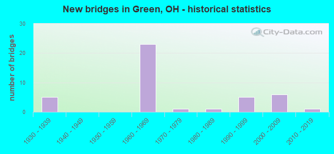
- New bridges - historical statistics
- 51930-1939
- 231960-1969
- 11970-1979
- 11980-1989
- 51990-1999
- 62000-2009
- 12010-2019

- Reconstructed bridges - Historical Statistics
- 41990-1999
- 82000-2009


- Bridge Condition - Deck
- 30.8%Very good
- 53.8%Good
- 7.7%Satisfactory
- 3.8%Fair
- 3.8%Poor

- Bridge Condition - Superstructure
- 50.0%Very good
- 30.8%Good
- 7.7%Satisfactory
- 3.8%Fair
- 3.8%Poor
- 3.8%Serious

- Bridge Condition - Substructure
- 57.7%Very good
- 23.1%Good
- 15.4%Satisfactory
- 3.8%Poor

- Bridge Condition - Channel
- 25.0%Very good
- 18.8%Good
- 50.0%Satisfactory
- 6.3%Fair
Find on map >> Show street view
Structure Number: 7604777, Location: 4.50 MI S OF SR 241 (Lat: 40.906600, Lng: -81.428711), Route carried "on" structure: Interstate 77, Year Built: 1963, Year Reconstructed: 2003, Status: Open, Structure Length: 3.60m (11.81ft), Average Daily Traffic: 42,335 (year 2015), Truck Traffic: 7%, Average Future Daily Traffic: 58,761 (year 2035), Design Load: HS 20+Mod, Features Intersected: OVER MT PLEASANT RD CR-7
Minimum Vertical Clearance: 30+ m (98+ ft), Kilometerpoint: 29.821, Lanes on structure: 3, Lanes under structure: 2, Base Highway Network: Yes, Owner: State Highway Agency, Approaching Roadway Width: 18.9m (62.0ft), Material/Design: Steel continuous, Design/Construction: Stringer/Multi-beam, Number Of Spans In Main Unit: 3, Length of Maximum Span: 13.3m (43.6ft), Curb-To-Curb Width: 19.1m (62.7ft), Out-to-Out Width: 19.8m (65.0ft)
Condition: Deck: Very good, Superstructure: Very good, Substructure: Very good, Operating Rating: 97.2 metric tons, Method Used To Determine Operating Rating: Load Factor (LF) rating reported by rating factor (RF) method using MS18 loading, Inventory Rating: 61.6 metric tons, Method Used To Determine Inventory Rating: Load Factor (LF) rating reported by rating factor (RF) method using MS18 loading, Structural Evaluation: Equal to present desirable criteria, Deck Geometry: Superior to present desirable criteria, Underclear: Meets minimum limits, Approach Roadway Alignment: Equal to present desirable criteria, Designated Inspection Frequency: Every 24 months, Inspection Date: August 2021, Deck Structure Type: Concrete Cast-file-Place, Wearing Surface/Protective System: Wearing Surface: Monolithic Concrete, Deck Protection: Epoxy Coated Reinforcing
Find on map >> Show street view
Structure Number: 7604807, Location: 4.50 MI S OF SR 241 (Lat: 40.906669, Lng: -81.428331), Route carried "on" structure: Interstate 77, Year Built: 1963, Year Reconstructed: 2003, Status: Open, Structure Length: 3.60m (11.81ft), Average Daily Traffic: 42,335 (year 2015), Truck Traffic: 7%, Average Future Daily Traffic: 58,761 (year 2035), Design Load: HS 20, Features Intersected: OVER MT PLEASANT RD CR-7
Minimum Vertical Clearance: 30+ m (98+ ft), Kilometerpoint: 29.821, Lanes on structure: 3, Lanes under structure: 2, Base Highway Network: Yes, Owner: State Highway Agency, Approaching Roadway Width: 18.9m (62.0ft), Material/Design: Steel continuous, Design/Construction: Stringer/Multi-beam, Number Of Spans In Main Unit: 3, Length of Maximum Span: 13.3m (43.6ft), Curb-To-Curb Width: 19.1m (62.7ft), Out-to-Out Width: 19.8m (65.0ft)
Condition: Deck: Very good, Superstructure: Very good, Substructure: Very good, Operating Rating: 84.2 metric tons, Method Used To Determine Operating Rating: Load and Resistance Factor Rating (LRFR) rating reported by rating factor(RF) method using HL-93 loadings, Inventory Rating: 64.8 metric tons, Method Used To Determine Inventory Rating: Load and Resistance Factor Rating (LRFR) rating reported by rating factor(RF) method using HL-93 loadings, Structural Evaluation: Equal to present desirable criteria, Deck Geometry: Superior to present desirable criteria, Underclear: Meets minimum limits, Approach Roadway Alignment: Equal to present desirable criteria, Designated Inspection Frequency: Every 24 months, Inspection Date: August 2021, Deck Structure Type: Concrete Cast-file-Place, Wearing Surface/Protective System: Wearing Surface: Monolithic Concrete, Deck Protection: Epoxy Coated Reinforcing
Find on map >> Show street view
Structure Number: 7633254, Location: 0.0 MI. E. OF TR234 (Lat: 40.908889, Lng: -81.496869), Route carried "on" structure: County highway C0007, Year Built: 1978, Year Reconstructed: 2011, Status: Open, Structure Length: 1.34m (4.40ft), Average Daily Traffic: 1,887 (year 2015), Truck Traffic: 5%, Average Future Daily Traffic: 2,619 (year 2035), Design Load: HL 93, Features Intersected: WILLOWDALE CREEK, Facility Carried by Structure: JA0411 MT PLEASANT
Minimum Vertical Clearance: 30+ m (98+ ft), Kilometerpoint: 3.235, Lanes on structure: 2, Owner: County Highway Agency, Approaching Roadway Width: 7.3m (24.0ft), Skew: 3 degrees, Material/Design: Prestressed concrete, Design/Construction: Box Beam or Girders - Multiple, Number Of Spans In Main Unit: 1, Length of Maximum Span: 12.2m (40.0ft), Curb-To-Curb Width: 11.0m (36.1ft), Out-to-Out Width: 11.0m (36.1ft)
Condition: Deck: Very good, Superstructure: Very good, Substructure: Satisfactory, Channel: Fair, Operating Rating: 97.2 metric tons, Method Used To Determine Operating Rating: Load Factor (LF) rating reported by rating factor (RF) method using MS18 loading, Inventory Rating: 61.6 metric tons, Method Used To Determine Inventory Rating: Load Factor (LF) rating reported by rating factor (RF) method using MS18 loading, Structural Evaluation: Equal to present minimum criteria, Deck Geometry: Equal to present minimum criteria, Waterway Adequacy: Equal to present desirable criteria, Approach Roadway Alignment: Equal to present desirable criteria, Designated Inspection Frequency: Every 12 months, Inspection Date: October 2021, Deck Structure Type: Concrete Cast-file-Place, Wearing Surface/Protective System: Wearing Surface: Bituminous, Membrane: Built-up, Deck Protection: Epoxy Coated Reinforcing
Find on map >> Show street view
Structure Number: 7702108, Location: 3.97 MI S OF SR 241 (Lat: 40.914531, Lng: -81.427389), Route carried "on" structure: Other road ARPRT, Year Built: 1963, Year Reconstructed: 2003, Status: Open, Structure Length: 9.21m (30.22ft), Average Daily Traffic: 5,300 (year 2003), Truck Traffic: 12%, Average Future Daily Traffic: 83,029 (year 2023), Design Load: HS 20+Mod, Features Intersected: I-77, Facility Carried by Structure: AIRPORT ROAD
Minimum Vertical Clearance: 30+ m (98+ ft), Kilometerpoint: 1.304, Lanes on structure: 2, Lanes under structure: 4, Owner: State Highway Agency, Approaching Roadway Width: 14.6m (47.9ft), Skew: 20 degrees, Material/Design: Steel continuous, Design/Construction: Stringer/Multi-beam, Number Of Spans In Main Unit: 4, Length of Maximum Span: 27.3m (89.6ft), Curb-To-Curb Width: 18.6m (61.0ft), Out-to-Out Width: 19.5m (64.0ft)
Condition: Deck: Good, Superstructure: Very good, Substructure: Good, Operating Rating: 42.1 metric tons, Method Used To Determine Operating Rating: Allowable Stress (AS) rating reported by rating factor (RF) method using MS18 loading, Inventory Rating: 32.4 metric tons, Method Used To Determine Inventory Rating: Allowable Stress (AS) rating reported by rating factor (RF) method using MS18 loading, Structural Evaluation: Better than present minimum criteria, Deck Geometry: Superior to present desirable criteria, Underclear: High priority of corrective action, Approach Roadway Alignment: Better than present minimum criteria, Designated Inspection Frequency: Every 24 months, Inspection Date: May 2021, Deck Structure Type: Concrete Cast-file-Place, Wearing Surface/Protective System: Wearing Surface: Monolithic Concrete, Deck Protection: Epoxy Coated Reinforcing
Find on map >> Show street view
Structure Number: 7702132, Location: 2.86 MI S OF SR 241 (Lat: 40.928689, Lng: -81.432769), Route carried "on" structure: Interstate 77, Year Built: 1963, Year Reconstructed: 2006, Status: Open, Structure Length: 4.27m (14.01ft), Average Daily Traffic: 44,976 (year 2015), Truck Traffic: 6%, Average Future Daily Traffic: 62,427 (year 2035), Design Load: HS 20+Mod, Features Intersected: OVER GREENSBURG RD CR-13
Minimum Vertical Clearance: 30+ m (98+ ft), Kilometerpoint: 2.527, Lanes on structure: 3, Lanes under structure: 2, Base Highway Network: Yes, Owner: State Highway Agency, Approaching Roadway Width: 13.4m (44.0ft), Skew: 3 degrees, Material/Design: Steel continuous, Design/Construction: Stringer/Multi-beam, Number Of Spans In Main Unit: 3, Length of Maximum Span: 16.2m (53.1ft), Curb-To-Curb Width: 18.9m (62.0ft), Out-to-Out Width: 19.8m (65.0ft)
Condition: Deck: Very good, Superstructure: Very good, Substructure: Very good, Operating Rating: 42.1 metric tons, Method Used To Determine Operating Rating: Allowable Stress (AS) rating reported by rating factor (RF) method using MS18 loading, Inventory Rating: 32.4 metric tons, Method Used To Determine Inventory Rating: Allowable Stress (AS) rating reported by rating factor (RF) method using MS18 loading, Structural Evaluation: Equal to present desirable criteria, Deck Geometry: Superior to present desirable criteria, Underclear: Meets minimum limits, Approach Roadway Alignment: Better than present minimum criteria, Designated Inspection Frequency: Every 24 months, Inspection Date: May 2021, Deck Structure Type: Concrete Cast-file-Place, Wearing Surface/Protective System: Wearing Surface: Monolithic Concrete, Deck Protection: Epoxy Coated Reinforcing
Find on map >> Show street view
Structure Number: 7702167, Location: 2.86 MI S OF SR 241 (Lat: 40.928689, Lng: -81.432250), Route carried "on" structure: Interstate 77, Year Built: 1963, Year Reconstructed: 2006, Status: Open, Structure Length: 4.27m (14.01ft), Average Daily Traffic: 44,976 (year 2015), Truck Traffic: 6%, Average Future Daily Traffic: 62,427 (year 2035), Design Load: HS 20+Mod, Features Intersected: OVER GREENSBURG RD CR-13
Minimum Vertical Clearance: 30+ m (98+ ft), Kilometerpoint: 2.527, Lanes on structure: 3, Lanes under structure: 2, Base Highway Network: Yes, Owner: State Highway Agency, Approaching Roadway Width: 13.4m (44.0ft), Skew: 3 degrees, Material/Design: Steel continuous, Design/Construction: Stringer/Multi-beam, Number Of Spans In Main Unit: 3, Length of Maximum Span: 16.2m (53.1ft), Curb-To-Curb Width: 18.9m (62.0ft), Out-to-Out Width: 19.8m (65.0ft)
Condition: Deck: Very good, Superstructure: Very good, Substructure: Very good, Operating Rating: 42.1 metric tons, Method Used To Determine Operating Rating: Allowable Stress (AS) rating reported by rating factor (RF) method using MS18 loading, Inventory Rating: 32.4 metric tons, Method Used To Determine Inventory Rating: Allowable Stress (AS) rating reported by rating factor (RF) method using MS18 loading, Structural Evaluation: Equal to present desirable criteria, Deck Geometry: Superior to present desirable criteria, Underclear: Meets minimum limits, Approach Roadway Alignment: Better than present minimum criteria, Designated Inspection Frequency: Every 24 months, Inspection Date: May 2021, Deck Structure Type: Concrete Cast-file-Place, Wearing Surface/Protective System: Wearing Surface: Monolithic Concrete, Deck Protection: Epoxy Coated Reinforcing
Find on map >> Show street view
Structure Number: 7702221, Location: 1.65 MI S OF SR 241 (Lat: 40.943919, Lng: -81.446339), Route carried "on" structure: County highway C0007, Year Built: 1964, Year Reconstructed: 2006, Status: Open, Structure Length: 10.55m (34.61ft), Average Daily Traffic: 6,602 (year 2015), Truck Traffic: 5%, Average Future Daily Traffic: 124,852 (year 2035), Design Load: H 10, Features Intersected: I-77, Facility Carried by Structure: WISE ROAD CR 250
Minimum Vertical Clearance: 30+ m (98+ ft), Kilometerpoint: 1.078, Lanes on structure: 2, Lanes under structure: 4, Owner: State Highway Agency, Approaching Roadway Width: 6.1m (20.0ft), Skew: 3 degrees, Material/Design: Steel continuous, Design/Construction: Stringer/Multi-beam, Number Of Spans In Main Unit: 4, Length of Maximum Span: 29.6m (97.1ft), Curb-To-Curb Width: 7.3m (24.0ft), Out-to-Out Width: 9.4m (30.8ft)
Condition: Deck: Good, Superstructure: Good, Substructure: Very good, Operating Rating: 32.4 metric tons, Method Used To Determine Operating Rating: Load and Resistance Factor Rating (LRFR) rating reported by rating factor(RF) method using HL-93 loadings, Inventory Rating: 24.9 metric tons, Method Used To Determine Inventory Rating: Load and Resistance Factor Rating (LRFR) rating reported by rating factor(RF) method using HL-93 loadings, Structural Evaluation: Equal to present minimum criteria, Deck Geometry: High priority of replacement, Underclear: High priority of corrective action, Approach Roadway Alignment: Better than present minimum criteria, Designated Inspection Frequency: Every 24 months, Inspection Date: May 2021, Deck Structure Type: Concrete Cast-file-Place, Wearing Surface/Protective System: Wearing Surface: Monolithic Concrete, Deck Protection: Epoxy Coated Reinforcing
Find on map >> Show street view
Structure Number: 7702256, Location: 0.76 MI S OF SR 241 (Lat: 40.955031, Lng: -81.455981), Route carried "on" structure: County highway C3575, Year Built: 1964, Year Reconstructed: 2005, Status: Open, Structure Length: 8.69m (28.51ft), Average Daily Traffic: 6,602 (year 2015), Truck Traffic: 5%, Average Future Daily Traffic: 124,852 (year 2035), Design Load: HS 20+Mod, Features Intersected: I-77, Facility Carried by Structure: GRAYBILL RD CR3575
Minimum Vertical Clearance: 30+ m (98+ ft), Kilometerpoint: 0.885, Lanes on structure: 2, Lanes under structure: 6, Owner: State Highway Agency, Approaching Roadway Width: 6.1m (20.0ft), Material/Design: Steel continuous, Design/Construction: Stringer/Multi-beam, Number Of Spans In Main Unit: 4, Length of Maximum Span: 24.4m (80.1ft), Curb-To-Curb Width: 7.3m (24.0ft), Out-to-Out Width: 9.4m (30.8ft)
Condition: Deck: Good, Superstructure: Good, Substructure: Very good, Operating Rating: 42.1 metric tons, Method Used To Determine Operating Rating: Load Factor (LF) rating reported by rating factor (RF) method using MS18 loading, Inventory Rating: 25.9 metric tons, Method Used To Determine Inventory Rating: Load Factor (LF) rating reported by rating factor (RF) method using MS18 loading, Structural Evaluation: Equal to present minimum criteria, Deck Geometry: High priority of replacement, Underclear: High priority of corrective action, Approach Roadway Alignment: Better than present minimum criteria, Designated Inspection Frequency: Every 24 months, Inspection Date: May 2021, Deck Structure Type: Concrete Cast-file-Place, Wearing Surface/Protective System: Wearing Surface: Monolithic Concrete, Deck Protection: Epoxy Coated Reinforcing
Find on map >> Show street view
Structure Number: 7702299, Location: JCT IR 77 AND SR 241 (Lat: 40.963269, Lng: -81.464781), Route carried "on" structure: Interstate 77, Year Built: 2000, Status: Open, Structure Length: 8.56m (28.08ft), Average Daily Traffic: 38,616 (year 2015), Truck Traffic: 6%, Average Future Daily Traffic: 53,599 (year 2035), Design Load: HS 20+Mod, Features Intersected: OVER SUM-SR 241-3.87
Minimum Vertical Clearance: 30+ m (98+ ft), Kilometerpoint: 7.258, Lanes on structure: 3, Lanes under structure: 7, Base Highway Network: Yes, Owner: State Highway Agency, Approaching Roadway Width: 13.4m (44.0ft), Skew: 4 degrees, Material/Design: Steel continuous, Design/Construction: Stringer/Multi-beam, Number Of Spans In Main Unit: 3, Length of Maximum Span: 45.1m (148.0ft), Curb-To-Curb Width: 19.5m (64.0ft), Out-to-Out Width: 20.4m (66.9ft)
Condition: Deck: Good, Superstructure: Very good, Substructure: Very good, Operating Rating: 64.8 metric tons, Method Used To Determine Operating Rating: Load and Resistance Factor Rating (LRFR) rating reported by rating factor(RF) method using HL-93 loadings, Inventory Rating: 48.6 metric tons, Method Used To Determine Inventory Rating: Load and Resistance Factor Rating (LRFR) rating reported by rating factor(RF) method using HL-93 loadings, Structural Evaluation: Equal to present desirable criteria, Deck Geometry: Superior to present desirable criteria, Underclear: High priority of corrective action, Approach Roadway Alignment: Better than present minimum criteria, Designated Inspection Frequency: Every 24 months, Inspection Date: May 2021, Deck Structure Type: Concrete Cast-file-Place, Wearing Surface/Protective System: Wearing Surface: Monolithic Concrete, Membrane: Epoxy, Deck Protection: Other Coated Reinforcing
Find on map >> Show street view
Structure Number: 7702329, Location: JCT 0F IR 77 AND SR 241 (Lat: 40.963700, Lng: -81.464681), Route carried "on" structure: Interstate 77, Year Built: 2000, Status: Open, Structure Length: 8.56m (28.08ft), Average Daily Traffic: 38,616 (year 2015), Truck Traffic: 6%, Average Future Daily Traffic: 53,599 (year 2035), Design Load: HS 20+Mod, Features Intersected: OVER SUM-SR 241-3.90
Minimum Vertical Clearance: 30+ m (98+ ft), Kilometerpoint: 7.258, Lanes on structure: 3, Lanes under structure: 7, Base Highway Network: Yes, Owner: State Highway Agency, Approaching Roadway Width: 19.5m (64.0ft), Skew: 4 degrees, Material/Design: Steel continuous, Design/Construction: Stringer/Multi-beam, Number Of Spans In Main Unit: 3, Length of Maximum Span: 45.1m (148.0ft), Curb-To-Curb Width: 19.5m (64.0ft), Out-to-Out Width: 20.4m (66.9ft)
Condition: Deck: Good, Superstructure: Very good, Substructure: Very good, Operating Rating: 64.8 metric tons, Method Used To Determine Operating Rating: Load and Resistance Factor Rating (LRFR) rating reported by rating factor(RF) method using HL-93 loadings, Inventory Rating: 48.6 metric tons, Method Used To Determine Inventory Rating: Load and Resistance Factor Rating (LRFR) rating reported by rating factor(RF) method using HL-93 loadings, Structural Evaluation: Equal to present desirable criteria, Deck Geometry: Superior to present desirable criteria, Underclear: High priority of corrective action, Approach Roadway Alignment: Better than present minimum criteria, Designated Inspection Frequency: Every 24 months, Inspection Date: May 2021, Deck Structure Type: Concrete Cast-file-Place, Wearing Surface/Protective System: Wearing Surface: Monolithic Concrete, Membrane: Epoxy, Deck Protection: Epoxy Coated Reinforcing
Find on map >> Show street view
Structure Number: 7702345, Location: 1.20 MI N OF SR 619 (Lat: 40.987000, Lng: -81.492450), Route carried "on" structure: Interstate 77, Year Built: 1965, Year Reconstructed: 2000, Status: Open, Structure Length: 9.11m (29.89ft), Average Daily Traffic: 46,609 (year 2015), Truck Traffic: 6%, Average Future Daily Traffic: 64,693 (year 2035), Design Load: HS 20+Mod, Features Intersected: OVER S ARLINGTON RD CR-1
Minimum Vertical Clearance: 30+ m (98+ ft), Kilometerpoint: 10.815, Lanes on structure: 3, Lanes under structure: 4, Base Highway Network: Yes, Owner: State Highway Agency, Approaching Roadway Width: 13.4m (44.0ft), Skew: 5 degrees, Material/Design: Steel continuous, Design/Construction: Stringer/Multi-beam, Number Of Spans In Main Unit: 4, Length of Maximum Span: 24.4m (80.1ft), Curb-To-Curb Width: 19.5m (64.0ft), Out-to-Out Width: 20.4m (66.9ft)
Condition: Deck: Good, Superstructure: Very good, Substructure: Very good, Operating Rating: 42.1 metric tons, Method Used To Determine Operating Rating: Allowable Stress (AS) rating reported by rating factor (RF) method using MS18 loading, Inventory Rating: 32.4 metric tons, Method Used To Determine Inventory Rating: Allowable Stress (AS) rating reported by rating factor (RF) method using MS18 loading, Structural Evaluation: Equal to present desirable criteria, Deck Geometry: Superior to present desirable criteria, Underclear: Somewhat better than minimum adequacy, Approach Roadway Alignment: Better than present minimum criteria, Designated Inspection Frequency: Every 24 months, Inspection Date: May 2021, Deck Structure Type: Concrete Cast-file-Place, Wearing Surface/Protective System: Wearing Surface: Monolithic Concrete, Membrane: Epoxy, Deck Protection: Epoxy Coated Reinforcing
Find on map >> Show street view
Structure Number: 7702434, Location: 1.20 MI N OF SR 619 (Lat: 40.987511, Lng: -81.492381), Route carried "on" structure: Interstate 77, Year Built: 1965, Year Reconstructed: 2000, Status: Open, Structure Length: 9.54m (31.30ft), Average Daily Traffic: 46,609 (year 2015), Truck Traffic: 6%, Average Future Daily Traffic: 64,693 (year 2035), Design Load: HS 20+Mod, Features Intersected: OVER S ARLINGTON RD CR-1
Minimum Vertical Clearance: 30+ m (98+ ft), Kilometerpoint: 10.815, Lanes on structure: 4, Lanes under structure: 4, Base Highway Network: Yes, Owner: State Highway Agency, Approaching Roadway Width: 15.9m (52.2ft), Skew: 5 degrees, Material/Design: Steel continuous, Design/Construction: Stringer/Multi-beam, Number Of Spans In Main Unit: 4, Length of Maximum Span: 26.2m (86.0ft), Curb-To-Curb Width: 23.2m (76.1ft), Out-to-Out Width: 24.1m (79.1ft)
Condition: Deck: Good, Superstructure: Very good, Substructure: Very good, Operating Rating: 42.1 metric tons, Method Used To Determine Operating Rating: Allowable Stress (AS) rating reported by rating factor (RF) method using MS18 loading, Inventory Rating: 32.4 metric tons, Method Used To Determine Inventory Rating: Allowable Stress (AS) rating reported by rating factor (RF) method using MS18 loading, Structural Evaluation: Equal to present desirable criteria, Deck Geometry: Superior to present desirable criteria, Underclear: Somewhat better than minimum adequacy, Approach Roadway Alignment: Better than present minimum criteria, Designated Inspection Frequency: Every 24 months, Inspection Date: May 2021, Deck Structure Type: Concrete Cast-file-Place, Wearing Surface/Protective System: Wearing Surface: Monolithic Concrete, Membrane: Epoxy, Deck Protection: Other Coated Reinforcing
Find on map >> Show street view
Structure Number: 7702469, Location: 1.91 MI N OF SR 619 (Lat: 40.997339, Lng: -81.493531), Route carried "on" structure: County highway C0135, Year Built: 1966, Year Reconstructed: 2001, Status: Open, Structure Length: 8.61m (28.25ft), Average Daily Traffic: 7,594 (year 2015), Truck Traffic: 3%, Average Future Daily Traffic: 163,740 (year 2035), Design Load: HS 20+Mod, Features Intersected: IR77, Facility Carried by Structure: KILLIAN RD CR 135
Minimum Vertical Clearance: 30+ m (98+ ft), Kilometerpoint: 2.478, Lanes on structure: 3, Lanes under structure: 8, Owner: State Highway Agency, Approaching Roadway Width: 10.8m (35.4ft), Material/Design: Steel continuous, Design/Construction: Stringer/Multi-beam, Number Of Spans In Main Unit: 4, Length of Maximum Span: 25.0m (82.0ft), Curb-To-Curb Width: 16.8m (55.1ft), Out-to-Out Width: 17.7m (58.1ft)
Condition: Deck: Good, Superstructure: Good, Substructure: Good, Operating Rating: 42.1 metric tons, Method Used To Determine Operating Rating: Load Factor (LF) rating reported by rating factor (RF) method using MS18 loading, Inventory Rating: 32.4 metric tons, Method Used To Determine Inventory Rating: Load Factor (LF) rating reported by rating factor (RF) method using MS18 loading, Structural Evaluation: Better than present minimum criteria, Deck Geometry: Superior to present desirable criteria, Underclear: High priority of corrective action, Approach Roadway Alignment: Better than present minimum criteria, Designated Inspection Frequency: Every 24 months, Inspection Date: May 2021, Deck Structure Type: Concrete Cast-file-Place, Wearing Surface/Protective System: Wearing Surface: Monolithic Concrete, Deck Protection: Epoxy Coated Reinforcing
Find on map >> Show street view
Structure Number: 7708009, Location: 2.15 MI N OF IR 77 (Lat: 40.994639, Lng: -81.461931), Route carried "on" structure: State highway 241, Year Built: 1990, Status: Open, Structure Length: 1.55m (5.09ft), Average Daily Traffic: 10,042 (year 2015), Truck Traffic: 5%, Average Future Daily Traffic: 13,938 (year 2035), Design Load: HS 20+Mod, Features Intersected: TUSCARAWAS RIVER
Minimum Vertical Clearance: 30+ m (98+ ft), Kilometerpoint: 9.753, Lanes on structure: 3, Base Highway Network: Yes, Owner: State Highway Agency, Approaching Roadway Width: 13.4m (44.0ft), Material/Design: Prestressed concrete, Design/Construction: Box Beam or Girders - Multiple, Number Of Spans In Main Unit: 1, Length of Maximum Span: 14.3m (46.9ft), Curb-To-Curb Width: 13.4m (44.0ft), Out-to-Out Width: 14.3m (46.9ft)
Condition: Deck: Good, Superstructure: Good, Substructure: Very good, Channel: Very good, Operating Rating: 81.0 metric tons, Method Used To Determine Operating Rating: Load Factor (LF) rating reported by rating factor (RF) method using MS18 loading, Inventory Rating: 42.1 metric tons, Method Used To Determine Inventory Rating: Load Factor (LF) rating reported by rating factor (RF) method using MS18 loading, Structural Evaluation: Better than present minimum criteria, Deck Geometry: Somewhat better than minimum adequacy, Waterway Adequacy: Equal to present desirable criteria, Approach Roadway Alignment: Equal to present desirable criteria, Designated Inspection Frequency: Every 24 months, Inspection Date: August 2021, Deck Structure Type: Concrete Cast-file-Place, Wearing Surface/Protective System: Wearing Surface: Monolithic Concrete, Deck Protection: Epoxy Coated Reinforcing
Find on map >> Show street view
Structure Number: 7711131, Location: JCT OF IR 77 AND SR 619 (Lat: 40.974211, Lng: -81.478361), Route carried "on" structure: State highway 619, Year Built: 1964, Year Reconstructed: 2000, Status: Open, Structure Length: 12.01m (39.40ft), Average Daily Traffic: 11,037 (year 2018), Truck Traffic: 4%, Average Future Daily Traffic: 15,319 (year 2038), Design Load: H 20, Features Intersected: OVER SUM-IR 77-5.52
Minimum Vertical Clearance: 30+ m (98+ ft), Kilometerpoint: 14.903, Lanes on structure: 2, Lanes under structure: 4, Owner: State Highway Agency, Approaching Roadway Width: 7.3m (24.0ft), Skew: 4 degrees, Material/Design: Steel continuous, Design/Construction: Stringer/Multi-beam, Number Of Spans In Main Unit: 4, Length of Maximum Span: 33.8m (110.9ft), Curb-To-Curb Width: 9.1m (29.9ft), Out-to-Out Width: 11.2m (36.7ft)
Condition: Deck: Satisfactory, Superstructure: Satisfactory, Substructure: Good, Operating Rating: 38.9 metric tons, Method Used To Determine Operating Rating: Load and Resistance Factor Rating (LRFR) rating reported by rating factor(RF) method using HL-93 loadings, Inventory Rating: 29.2 metric tons, Method Used To Determine Inventory Rating: Load and Resistance Factor Rating (LRFR) rating reported by rating factor(RF) method using HL-93 loadings, Structural Evaluation: Equal to present minimum criteria, Deck Geometry: Meets minimum limits, Underclear: Meets minimum limits, Approach Roadway Alignment: Equal to present desirable criteria, Designated Inspection Frequency: Every 12 months, Inspection Date: May 2021, Deck Structure Type: Concrete Cast-file-Place, Wearing Surface/Protective System: Wearing Surface: Monolithic Concrete
Find on map >> Show street view
Structure Number: 7711174, Location: 1.98 MI E OF SR 241 (Lat: 40.976139, Lng: -81.426211), Route carried "on" structure: State highway 619, Year Built: 2013, Status: Open, Structure Length: 0.85m (2.79ft), Average Daily Traffic: 7,385 (year 2015), Truck Traffic: 5%, Average Future Daily Traffic: 10,250 (year 2035), Design Load: HL 93, Features Intersected: BR TUSCARAWAS RIVER
Minimum Vertical Clearance: 30+ m (98+ ft), Kilometerpoint: 19.377, Lanes on structure: 2, Base Highway Network: Yes, Owner: State Highway Agency, Approaching Roadway Width: 13.4m (44.0ft), Material/Design: Concrete, Design/Construction: Frame, Number Of Spans In Main Unit: 1, Length of Maximum Span: 8.5m (27.9ft), Curb-To-Curb Width: 13.6m (44.6ft), Out-to-Out Width: 14.4m (47.2ft)
Condition: Deck: Very good, Superstructure: Very good, Substructure: Very good, Channel: Very good, Operating Rating: 42.1 metric tons, Method Used To Determine Operating Rating: Load Factor (LF) rating reported by rating factor (RF) method using MS18 loading, Inventory Rating: 29.2 metric tons, Method Used To Determine Inventory Rating: Load Factor (LF) rating reported by rating factor (RF) method using MS18 loading, Structural Evaluation: Better than present minimum criteria, Deck Geometry: Superior to present desirable criteria, Waterway Adequacy: Better than present minimum criteria, Approach Roadway Alignment: Equal to present minimum criteria, Designated Inspection Frequency: Every 24 months, Inspection Date: August 2021, Deck Structure Type: Concrete Cast-file-Place, Wearing Surface/Protective System: Wearing Surface: Monolithic Concrete, Deck Protection: Epoxy Coated Reinforcing
Find on map >> Show street view
Structure Number: 7738935, Location: 121 MI S OF COUNTY LINE (Lat: 40.956839, Lng: -81.440711), Route carried "on" structure: County highway C0248, Year Built: 1994, Status: Open, Structure Length: 0.64m (2.10ft), Average Daily Traffic: 6,602 (year 2015), Truck Traffic: 5%, Average Future Daily Traffic: 9,164 (year 2035), Design Load: HS 20+Mod, Features Intersected: HECKMAN DITCH, Facility Carried by Structure: GRAYBILL RD
Minimum Vertical Clearance: 30+ m (98+ ft), Kilometerpoint: 1.947, Lanes on structure: 2, Owner: County Highway Agency, Approaching Roadway Width: 8.5m (27.9ft), Material/Design: Steel, Design/Construction: Culvert, Number Of Spans In Main Unit: 1, Length of Maximum Span: 6.4m (21.0ft)
Condition: Channel: Satisfactory, Culverts: Satisfactory, Operating Rating: 61.6 metric tons, Method Used To Determine Operating Rating: Load Factor (LF) rating reported by rating factor (RF) method using MS18 loading, Inventory Rating: 48.6 metric tons, Method Used To Determine Inventory Rating: Load Factor (LF) rating reported by rating factor (RF) method using MS18 loading, Structural Evaluation: Equal to present minimum criteria, Waterway Adequacy: Equal to present desirable criteria, Approach Roadway Alignment: Equal to present desirable criteria, Designated Inspection Frequency: Every 12 months, Inspection Date: March 2021
Find on map >> Show street view
Structure Number: 7739001, Location: 3850 FT N OF SR 619 (Lat: 40.986911, Lng: -81.521819), Route carried "on" structure: County highway C0050, Year Built: 2005, Status: Open, Structure Length: 18.44m (60.50ft), Average Daily Traffic: 12,341 (year 2015), Truck Traffic: 4%, Average Future Daily Traffic: 17,129 (year 2035), Design Load: HS 25 or greater, Features Intersected: COTTAGE GROVE LAKE, Facility Carried by Structure: SOUTH MAIN ST
Minimum Vertical Clearance: 30+ m (98+ ft), Kilometerpoint: 9.077, Lanes on structure: 4, Owner: County Highway Agency, Approaching Roadway Width: 15.9m (52.2ft), Material/Design: Steel continuous, Design/Construction: Stringer/Multi-beam, Number Of Spans In Main Unit: 10, Length of Maximum Span: 19.2m (63.0ft), Curb or Sidewalk Widths: Left: 1.7m (5.6ft), Right: 1.7m (5.6ft), Curb-To-Curb Width: 15.9m (52.2ft), Out-to-Out Width: 19.8m (65.0ft)
Condition: Deck: Very good, Superstructure: Very good, Substructure: Very good, Channel: Satisfactory, Operating Rating: 81.0 metric tons, Method Used To Determine Operating Rating: Load Factor (LF) rating reported by rating factor (RF) method using MS18 loading, Inventory Rating: 48.6 metric tons, Method Used To Determine Inventory Rating: Load Factor (LF) rating reported by rating factor (RF) method using MS18 loading, Structural Evaluation: Equal to present desirable criteria, Deck Geometry: Meets minimum limits, Waterway Adequacy: Superior to present desirable criteria, Approach Roadway Alignment: Superior to present desirable criteria, Designated Inspection Frequency: Every 24 months, Underwater Inspection Frequency: Every 60 months, Inspection Date: August 2021, Underwater Inspection Date: April 2021, Deck Structure Type: Concrete Cast-file-Place, Wearing Surface/Protective System: Wearing Surface: Monolithic Concrete, Deck Protection: Epoxy Coated Reinforcing
Find on map >> Show street view
Structure Number: 7739109, Location: 150 FT N OF COMET ROAD (Lat: 40.924519, Lng: -81.515569), Route carried "on" structure: City street M0239, Year Built: 1936, Status: Posted for load, Structure Length: 1.31m (4.30ft), Average Daily Traffic: 1,600 (year 2013), Truck Traffic: 1%, Average Future Daily Traffic: 1,616 (year 2033), Features Intersected: NIMISILA RESERVOIR, Facility Carried by Structure: CHRISTMAN ROAD
Minimum Vertical Clearance: 30+ m (98+ ft), Kilometerpoint: 1.674, Lanes on structure: 2, Owner: County Highway Agency, Approaching Roadway Width: 6.7m (22.0ft), Material/Design: Concrete, Design/Construction: Tee Beam, Number Of Spans In Main Unit: 1, Length of Maximum Span: 12.6m (41.3ft), Curb-To-Curb Width: 7.3m (24.0ft), Out-to-Out Width: 8.3m (27.2ft)
Condition: Deck: Fair, Superstructure: Serious, Substructure: Poor, Channel: Good, Operating Rating: 8.7 metric tons, Method Used To Determine Operating Rating: Load Factor (LF) rating reported by rating factor (RF) method using MS18 loading, Inventory Rating: 5.2 metric tons, Method Used To Determine Inventory Rating: Load Factor (LF) rating reported by rating factor (RF) method using MS18 loading, Structural Evaluation: High priority of corrective action, Deck Geometry: Meets minimum limits, Waterway Adequacy: Better than present minimum criteria, Approach Roadway Alignment: Equal to present desirable criteria, Bridge Posting: Required (Relationship of Operating Rating to Maximum Legal Load: > 39.9% below), Designated Inspection Frequency: Every 12 months, Other Special Inspection Frequency: Every 4 months, Inspection Date: November 2021, Other Special Inspection Date: November 2021, Deck Structure Type: Concrete Cast-file-Place, Wearing Surface/Protective System: Wearing Surface: Bituminous
Find on map >> Show street view
Structure Number: 7739117, Location: 400 N OF HECKMAN RD (Lat: 40.952050, Lng: -81.437031), Route carried "on" structure: County highway C0244, Year Built: 1936, Status: Open, Structure Length: 0.82m (2.69ft), Average Daily Traffic: 6,250 (year 2018), Truck Traffic: 5%, Average Future Daily Traffic: 8,675 (year 2038), Design Load: HS 15, Features Intersected: HECKMAN DITCH, Facility Carried by Structure: MAYFAIR RD
Minimum Vertical Clearance: 30+ m (98+ ft), Kilometerpoint: 5.311, Lanes on structure: 2, Owner: County Highway Agency, Approaching Roadway Width: 8.5m (27.9ft), Material/Design: Concrete, Design/Construction: Slab, Number Of Spans In Main Unit: 1, Length of Maximum Span: 7.3m (24.0ft), Curb-To-Curb Width: 9.1m (29.9ft), Out-to-Out Width: 10.1m (33.1ft)
Condition: Deck: Good, Superstructure: Satisfactory, Substructure: Satisfactory, Channel: Very good, Operating Rating: 48.6 metric tons, Method Used To Determine Operating Rating: Load Factor (LF) rating reported by rating factor (RF) method using MS18 loading, Inventory Rating: 29.2 metric tons, Method Used To Determine Inventory Rating: Load Factor (LF) rating reported by rating factor (RF) method using MS18 loading, Structural Evaluation: Equal to present minimum criteria, Deck Geometry: High priority of corrective action, Waterway Adequacy: Better than present minimum criteria, Approach Roadway Alignment: Equal to present desirable criteria, Designated Inspection Frequency: Every 12 months, Inspection Date: March 2021, Deck Structure Type: Concrete Cast-file-Place, Wearing Surface/Protective System: Wearing Surface: Bituminous
Find on map >> Show street view
Structure Number: 7739125, Location: 1700 FT E OF MAYFAIR RD (Lat: 40.965350, Lng: -81.430539), Route carried "on" structure: City street M0246, Year Built: 1960, Status: Open, Structure Length: 1.65m (5.41ft), Average Daily Traffic: 1,400 (year 1988), Truck Traffic: 1%, Average Future Daily Traffic: 1,943 (year 2008), Design Load: H 15, Features Intersected: BR TUSCARAWAS RIVER, Facility Carried by Structure: RABER ROAD
Minimum Vertical Clearance: 30+ m (98+ ft), Kilometerpoint: 2.929, Lanes on structure: 2, Owner: City or Municipal Highway Agency, Approaching Roadway Width: 7.9m (25.9ft), Skew: 2 degrees, Material/Design: Steel, Design/Construction: Culvert, Number Of Spans In Main Unit: 3, Length of Maximum Span: 3.7m (12.1ft)
Condition: Channel: Satisfactory, Culverts: Satisfactory, Operating Rating: 42.1 metric tons, Method Used To Determine Operating Rating: Load and Resistance Factor Rating (LRFR) rating reported by rating factor(RF) method using HL-93 loadings, Inventory Rating: 32.4 metric tons, Method Used To Determine Inventory Rating: Load and Resistance Factor Rating (LRFR) rating reported by rating factor(RF) method using HL-93 loadings, Structural Evaluation: Equal to present minimum criteria, Waterway Adequacy: Equal to present minimum criteria, Approach Roadway Alignment: Equal to present minimum criteria, Designated Inspection Frequency: Every 12 months, Inspection Date: March 2021
Find on map >> Show street view
Structure Number: 773937, Location: 1700 FT E OF MAYFAIR RD (Lat: 40.943381, Lng: -81.428319), Route carried "on" structure: City street M0250, Year Built: 1989, Status: Open, Structure Length: 0.76m (2.49ft), Average Daily Traffic: 1,600 (year 1988), Truck Traffic: 1%, Average Future Daily Traffic: 2,221 (year 2008), Design Load: HS 20, Features Intersected: YENNY DITCH, Facility Carried by Structure: WISE ROAD
Minimum Vertical Clearance: 30+ m (98+ ft), Kilometerpoint: 3.106, Lanes on structure: 2, Owner: City or Municipal Highway Agency, Approaching Roadway Width: 7.0m (23.0ft), Skew: 3 degrees, Material/Design: Concrete, Design/Construction: Frame, Number Of Spans In Main Unit: 1, Length of Maximum Span: 7.0m (23.0ft), Curb-To-Curb Width: 10.1m (33.1ft), Out-to-Out Width: 10.5m (34.4ft)
Condition: Deck: Good, Superstructure: Good, Substructure: Good, Channel: Satisfactory, Operating Rating: 61.6 metric tons, Method Used To Determine Operating Rating: Load Factor (LF) rating reported by rating factor (RF) method using MS18 loading, Inventory Rating: 35.6 metric tons, Method Used To Determine Inventory Rating: Load Factor (LF) rating reported by rating factor (RF) method using MS18 loading, Structural Evaluation: Better than present minimum criteria, Deck Geometry: Somewhat better than minimum adequacy, Waterway Adequacy: Equal to present desirable criteria, Approach Roadway Alignment: Equal to present desirable criteria, Designated Inspection Frequency: Every 24 months, Inspection Date: March 2021, Deck Structure Type: Concrete Cast-file-Place, Wearing Surface/Protective System: Wearing Surface: Bituminous, Deck Protection: Epoxy Coated Reinforcing
Find on map >> Show street view
Structure Number: 7739389, Location: 1700 FT N OF MT PLEASANT (Lat: 40.915000, Lng: -81.515000), Route carried "on" structure: City street M0239, Year Built: 1990, Status: Open, Structure Length: 0.98m (3.22ft), Average Daily Traffic: 1,050 (year 2012), Truck Traffic: 1%, Average Future Daily Traffic: 1,457 (year 2032), Design Load: HS 20, Features Intersected: LAKE NOAH OUTLET, Facility Carried by Structure: CHRISTMAN RD
Minimum Vertical Clearance: 30+ m (98+ ft), Kilometerpoint: 0.499, Lanes on structure: 2, Owner: County Highway Agency, Approaching Roadway Width: 7.0m (23.0ft), Material/Design: Concrete, Design/Construction: Culvert, Number Of Spans In Main Unit: 1, Length of Maximum Span: 9.1m (29.9ft)
Condition: Channel: Satisfactory, Culverts: Satisfactory, Operating Rating: 40.8 metric tons, Method Used To Determine Operating Rating: Field evaluation and documented engineering judgment, Inventory Rating: 32.7 metric tons, Method Used To Determine Inventory Rating: Field evaluation and documented engineering judgment, Structural Evaluation: Equal to present minimum criteria, Waterway Adequacy: Equal to present desirable criteria, Approach Roadway Alignment: Equal to present desirable criteria, Designated Inspection Frequency: Every 12 months, Inspection Date: March 2021
Find on map >> Show street view
Structure Number: 7739397, Location: 2550 FT E OF CHRISTMAN RD (Lat: 40.908989, Lng: -81.497150), Route carried "on" structure: County highway C0015, Year Built: 1992, Status: Open, Structure Length: 1.13m (3.71ft), Average Daily Traffic: 4,563 (year 2018), Truck Traffic: 2%, Average Future Daily Traffic: 6,333 (year 2038), Design Load: HS 20+Mod, Features Intersected: NIMISILA CREEK, Facility Carried by Structure: Arlington RD
Minimum Vertical Clearance: 30+ m (98+ ft), Kilometerpoint: 0.113, Lanes on structure: 2, Owner: County Highway Agency, Approaching Roadway Width: 12.2m (40.0ft), Material/Design: Concrete, Design/Construction: Slab, Number Of Spans In Main Unit: 1, Length of Maximum Span: 10.4m (34.1ft), Curb-To-Curb Width: 12.2m (40.0ft), Out-to-Out Width: 12.2m (40.0ft)
Condition: Deck: Good, Superstructure: Good, Substructure: Satisfactory, Channel: Satisfactory, Operating Rating: 71.3 metric tons, Method Used To Determine Operating Rating: Load Factor (LF) rating reported by rating factor (RF) method using MS18 loading, Inventory Rating: 42.1 metric tons, Method Used To Determine Inventory Rating: Load Factor (LF) rating reported by rating factor (RF) method using MS18 loading, Structural Evaluation: Equal to present minimum criteria, Deck Geometry: Equal to present minimum criteria, Waterway Adequacy: Equal to present minimum criteria, Approach Roadway Alignment: Equal to present desirable criteria, Designated Inspection Frequency: Every 12 months, Inspection Date: Febuary 2021, Deck Structure Type: Concrete Cast-file-Place, Wearing Surface/Protective System: Wearing Surface: Monolithic Concrete
Find on map >> Show street view
Structure Number: 77394, Location: 2550 FT E OF CHRISTMAN RD (Lat: 40.909261, Lng: -81.507369), Route carried "on" structure: County highway C0007, Year Built: 1992, Status: Posted for load, Structure Length: 1.98m (6.50ft), Average Daily Traffic: 1,550 (year 2014), Truck Traffic: 1%, Average Future Daily Traffic: 2,151 (year 2034), Design Load: HS 20+Mod, Features Intersected: NIMISILA CREEK, Facility Carried by Structure: MT PLEASANT RD
Minimum Vertical Clearance: 30+ m (98+ ft), Kilometerpoint: 2.414, Lanes on structure: 2, Owner: County Highway Agency, Approaching Roadway Width: 12.2m (40.0ft), Skew: 4 degrees, Material/Design: Prestressed concrete, Design/Construction: Box Beam or Girders - Multiple, Number Of Spans In Main Unit: 1, Length of Maximum Span: 18.3m (60.0ft), Curb-To-Curb Width: 12.2m (40.0ft), Out-to-Out Width: 12.2m (40.0ft)
Condition: Deck: Satisfactory, Superstructure: Fair, Substructure: Very good, Channel: Very good, Operating Rating: 27.5 metric tons, Method Used To Determine Operating Rating: Load Factor (LF) rating reported by rating factor (RF) method using MS18 loading, Inventory Rating: 16.5 metric tons, Method Used To Determine Inventory Rating: Load Factor (LF) rating reported by rating factor (RF) method using MS18 loading, Structural Evaluation: Meets minimum limits, Deck Geometry: Better than present minimum criteria, Waterway Adequacy: Better than present minimum criteria, Approach Roadway Alignment: Equal to present desirable criteria, Bridge Posting: Required (Relationship of Operating Rating to Maximum Legal Load: 20.0 - 29.9% below), Designated Inspection Frequency: Every 12 months, Inspection Date: July 2021, Deck Structure Type: Concrete Cast-file-Place, Wearing Surface/Protective System: Wearing Surface: Bituminous, Membrane: Preformed Fabric
Find on map >> Show street view
Structure Number: 7752059, Location: 1300 N OF KILLIAN RD (Lat: 40.999569, Lng: -81.473539), Route carried "on" structure: County highway C0070, Year Built: 1939, Status: Open, Structure Length: 1.71m (5.61ft), Average Daily Traffic: 1,485 (year 2018), Truck Traffic: 5%, Average Future Daily Traffic: 2,061 (year 2038), Design Load: H 15, Features Intersected: TUSCARAWAS RIVER, Facility Carried by Structure: PICKLE RD
Minimum Vertical Clearance: 30+ m (98+ ft), Kilometerpoint: 2.849, Lanes on structure: 2, Owner: County Highway Agency, Approaching Roadway Width: 8.5m (27.9ft), Material/Design: Concrete, Design/Construction: Slab, Number Of Spans In Main Unit: 2, Length of Maximum Span: 7.6m (24.9ft), Curb or Sidewalk Widths: Left: 0.2m (0.7ft), Right: 0.2m (0.7ft), Curb-To-Curb Width: 9.1m (29.9ft), Out-to-Out Width: 10.6m (34.8ft)
Condition: Deck: Good, Superstructure: Good, Substructure: Good, Channel: Satisfactory, Operating Rating: 35.6 metric tons, Method Used To Determine Operating Rating: Load Factor (LF) rating reported by rating factor (RF) method using MS18 loading, Inventory Rating: 19.4 metric tons, Method Used To Determine Inventory Rating: Load Factor (LF) rating reported by rating factor (RF) method using MS18 loading, Structural Evaluation: Somewhat better than minimum adequacy, Deck Geometry: Somewhat better than minimum adequacy, Waterway Adequacy: Equal to present desirable criteria, Approach Roadway Alignment: Equal to present desirable criteria, Designated Inspection Frequency: Every 24 months, Inspection Date: January 2021, Deck Structure Type: Concrete Cast-file-Place, Wearing Surface/Protective System: Wearing Surface: Bituminous
Find on map >> Show street view
Structure Number: 7752067, Location: 3000 FT S OF KILLIAN RD (Lat: 40.988681, Lng: -81.436589), Route carried "on" structure: County highway C0137, Year Built: 1939, Status: Posted for load, Structure Length: 1.30m (4.27ft), Average Daily Traffic: 2,069 (year 2015), Truck Traffic: 5%, Average Future Daily Traffic: 2,872 (year 2035), Design Load: H 15, Features Intersected: S FORK TUSCARAWAS RIVER, Facility Carried by Structure: PRESSLER RD
Minimum Vertical Clearance: 30+ m (98+ ft), Kilometerpoint: 0.032, Lanes on structure: 2, Owner: County Highway Agency, Approaching Roadway Width: 7.0m (23.0ft), Skew: 3 degrees, Material/Design: Concrete continuous, Design/Construction: Slab, Number Of Spans In Main Unit: 2, Length of Maximum Span: 6.1m (20.0ft), Curb or Sidewalk Widths: Left: 0.2m (0.7ft), Right: 0.2m (0.7ft), Curb-To-Curb Width: 9.2m (30.2ft), Out-to-Out Width: 10.2m (33.5ft)
Condition: Deck: Poor, Superstructure: Poor, Substructure: Satisfactory, Channel: Satisfactory, Operating Rating: 29.2 metric tons, Method Used To Determine Operating Rating: Load Factor (LF) rating reported by rating factor (RF) method using MS18 loading, Inventory Rating: 16.2 metric tons, Method Used To Determine Inventory Rating: Load Factor (LF) rating reported by rating factor (RF) method using MS18 loading, Structural Evaluation: Meets minimum limits, Deck Geometry: Meets minimum limits, Waterway Adequacy: Better than present minimum criteria, Approach Roadway Alignment: Equal to present minimum criteria, Bridge Posting: Required (Relationship of Operating Rating to Maximum Legal Load: 30.0 - 39.9% below), Designated Inspection Frequency: Every 12 months, Inspection Date: January 2021, Deck Structure Type: Concrete Cast-file-Place, Wearing Surface/Protective System: Wearing Surface: Bituminous
Find on map >> Show street view
Structure Number: 7752075, Location: 900 S OF KILLIAN RD (Lat: 40.993839, Lng: -81.445439), Route carried "on" structure: County highway C0137, Year Built: 1939, Status: Open, Structure Length: 1.40m (4.59ft), Average Daily Traffic: 2,069 (year 2015), Truck Traffic: 5%, Average Future Daily Traffic: 2,872 (year 2035), Design Load: H 15, Features Intersected: TUSCARAWAS RIVER, Facility Carried by Structure: PRESSLER RD
Minimum Vertical Clearance: 30+ m (98+ ft), Kilometerpoint: 1.352, Lanes on structure: 2, Owner: County Highway Agency, Approaching Roadway Width: 9.8m (32.2ft), Skew: 1 degrees, Material/Design: Concrete continuous, Design/Construction: Slab, Number Of Spans In Main Unit: 2, Length of Maximum Span: 6.1m (20.0ft), Curb-To-Curb Width: 9.1m (29.9ft), Out-to-Out Width: 10.4m (34.1ft)
Condition: Deck: Good, Superstructure: Good, Substructure: Good, Channel: Good, Operating Rating: 61.6 metric tons, Method Used To Determine Operating Rating: Load Factor (LF) rating reported by rating factor (RF) method using MS18 loading, Inventory Rating: 38.9 metric tons, Method Used To Determine Inventory Rating: Load Factor (LF) rating reported by rating factor (RF) method using MS18 loading, Structural Evaluation: Better than present minimum criteria, Deck Geometry: Meets minimum limits, Waterway Adequacy: Better than present minimum criteria, Approach Roadway Alignment: Equal to present desirable criteria, Designated Inspection Frequency: Every 24 months, Inspection Date: January 2021, Deck Structure Type: Concrete Cast-file-Place, Wearing Surface/Protective System: Wearing Surface: Bituminous
Find on map >> Show street view
Structure Number: 7752156, Location: 1100 FT E OF PICKLE RD (Lat: 40.995711, Lng: -81.469911), Route carried "on" structure: County highway 135, Year Built: 2004, Status: Open, Structure Length: 1.74m (5.71ft), Average Daily Traffic: 7,761 (year 2015), Truck Traffic: 3%, Average Future Daily Traffic: 10,772 (year 2035), Design Load: HS 20+Mod, Features Intersected: TUSCARAWAS RIVER, Facility Carried by Structure: KILLIAN RD
Minimum Vertical Clearance: 30+ m (98+ ft), Kilometerpoint: 4.571, Lanes on structure: 2, Owner: County Highway Agency, Approaching Roadway Width: 13.4m (44.0ft), Material/Design: Prestressed concrete, Design/Construction: Box Beam or Girders - Multiple, Number Of Spans In Main Unit: 1, Length of Maximum Span: 17.1m (56.1ft), Curb-To-Curb Width: 13.4m (44.0ft), Out-to-Out Width: 13.4m (44.0ft)
Condition: Deck: Very good, Superstructure: Very good, Substructure: Very good, Channel: Good, Operating Rating: 61.6 metric tons, Method Used To Determine Operating Rating: Load Factor (LF) rating reported by rating factor (RF) method using MS18 loading, Inventory Rating: 22.7 metric tons, Method Used To Determine Inventory Rating: Load Factor (LF) rating reported by rating factor (RF) method using MS18 loading, Structural Evaluation: Somewhat better than minimum adequacy, Deck Geometry: Equal to present minimum criteria, Waterway Adequacy: Equal to present desirable criteria, Approach Roadway Alignment: Superior to present desirable criteria, Designated Inspection Frequency: Every 24 months, Inspection Date: January 2021, Deck Structure Type: Concrete Cast-file-Place, Wearing Surface/Protective System: Wearing Surface: Monolithic Concrete, Deck Protection: Epoxy Coated Reinforcing
Find on map >> Show street view
Structure Number: 7604777, Location: 4.50 MI S OF SR 241 (Lat: 40.906600, Lng: -81.428711), Route carried "under" structure: County highway 7, Year Built: 1963, Structure Length: 0. m, Average Daily Traffic: 1,800 (year 1971), Features Intersected: IR 77
Minimum Vertical Clearance: 4.62m (15.16ft), Kilometerpoint: 0.547, Lanes on structure: 3, Lanes under structure: 2, Material/Design: Steel continuous, Design/Construction: Stringer/Multi-beam, Length of Maximum Span: 13.3m (43.6ft)
Find on map >> Show street view
Structure Number: 7604807, Location: 4.50 MI S OF SR 241 (Lat: 40.906669, Lng: -81.428331), Route carried "under" structure: County highway 7, Year Built: 1963, Structure Length: 0. m, Average Daily Traffic: 1,800 (year 1971), Features Intersected: IR 77
Minimum Vertical Clearance: 4.62m (15.16ft), Kilometerpoint: 0.563, Lanes on structure: 3, Lanes under structure: 2, Material/Design: Steel continuous, Design/Construction: Stringer/Multi-beam, Length of Maximum Span: 13.3m (43.6ft)
Find on map >> Show street view
Structure Number: 7702108, Location: 3.97 MI S OF SR 241 (Lat: 40.914531, Lng: -81.427389), Route carried "under" structure: Interstate 77, Year Built: 1963, Structure Length: 0. m, Average Daily Traffic: 59,819 (year 2015), Truck Traffic: 6%, Features Intersected: UNDER AIRPORT RD, Facility Carried by Structure: AIRPORT ROAD
Minimum Vertical Clearance: 5.93m (19.46ft), Kilometerpoint: 0.853, Lanes on structure: 2, Lanes under structure: 4, Material/Design: Steel continuous, Design/Construction: Stringer/Multi-beam, Length of Maximum Span: 27.3m (89.6ft)
Find on map >> Show street view
Structure Number: 7702132, Location: 2.86 MI S OF SR 241 (Lat: 40.928689, Lng: -81.432769), Route carried "under" structure: County highway 133, Year Built: 1963, Structure Length: 0. m, Average Daily Traffic: 7,794 (year 2015), Truck Traffic: 7%, Features Intersected: I-77, Facility Carried by Structure: I.R. 77
Minimum Vertical Clearance: 5.26m (17.26ft), Kilometerpoint: 6.325, Lanes on structure: 3, Lanes under structure: 2, Material/Design: Steel continuous, Design/Construction: Stringer/Multi-beam, Length of Maximum Span: 16.2m (53.1ft)
Find on map >> Show street view
Structure Number: 7702167, Location: 2.86 MI S OF SR 241 (Lat: 40.928689, Lng: -81.432250), Route carried "under" structure: County highway 133, Year Built: 1963, Structure Length: 0. m, Average Daily Traffic: 7,794 (year 2015), Truck Traffic: 7%, Features Intersected: I-77, Facility Carried by Structure: I.R. 77
Minimum Vertical Clearance: 5.26m (17.26ft), Kilometerpoint: 6.357, Lanes on structure: 3, Lanes under structure: 2, Material/Design: Steel continuous, Design/Construction: Stringer/Multi-beam, Length of Maximum Span: 16.2m (53.1ft)
Find on map >> Show street view
Structure Number: 7702221, Location: 1.65 MI S OF SR 241 (Lat: 40.943919, Lng: -81.446339), Route carried "under" structure: Interstate 77, Year Built: 1964, Structure Length: 0. m, Average Daily Traffic: 89,951 (year 2015), Truck Traffic: 6%, Features Intersected: UNDER WISE RD CR-250, Facility Carried by Structure: WISE ROAD CR 250
Minimum Vertical Clearance: 5.57m (18.27ft), Kilometerpoint: 4.571, Lanes on structure: 2, Lanes under structure: 4, Material/Design: Steel continuous, Design/Construction: Stringer/Multi-beam, Length of Maximum Span: 29.6m (97.1ft)
Find on map >> Show street view
Structure Number: 7702256, Location: 0.76 MI S OF SR 241 (Lat: 40.955031, Lng: -81.455981), Route carried "under" structure: Interstate 77, Year Built: 1964, Structure Length: 0. m, Average Daily Traffic: 89,951 (year 2015), Truck Traffic: 6%, Features Intersected: UNDER GRAYBILL RD CR-357, Facility Carried by Structure: GRAYBILL RD CR3575
Minimum Vertical Clearance: 5.19m (17.03ft), Kilometerpoint: 6.067, Lanes on structure: 2, Lanes under structure: 6, Material/Design: Steel continuous, Design/Construction: Stringer/Multi-beam, Length of Maximum Span: 24.4m (80.1ft)
Find on map >> Show street view
Structure Number: 7702299, Location: JCT IR 77 AND SR 241 (Lat: 40.963269, Lng: -81.464781), Route carried "under" structure: State highway 241, Year Built: 2000, Structure Length: 0. m, Average Daily Traffic: 23,747 (year 2015), Truck Traffic: 6%, Features Intersected: IR-77, Facility Carried by Structure: I.R. 77
Minimum Vertical Clearance: 4.90m (16.08ft), Kilometerpoint: 6.228, Lanes on structure: 3, Lanes under structure: 7, Material/Design: Steel continuous, Design/Construction: Stringer/Multi-beam, Length of Maximum Span: 45.1m (148.0ft)
Find on map >> Show street view
Structure Number: 7702329, Location: JCT 0F IR 77 AND SR 241 (Lat: 40.963700, Lng: -81.464681), Route carried "under" structure: State highway 241, Year Built: 2000, Structure Length: 0. m, Average Daily Traffic: 23,747 (year 2015), Truck Traffic: 6%, Features Intersected: JCT OF IR-77, Facility Carried by Structure: I.R. 77
Minimum Vertical Clearance: 4.67m (15.32ft), Kilometerpoint: 6.276, Lanes on structure: 3, Lanes under structure: 7, Material/Design: Steel continuous, Design/Construction: Stringer/Multi-beam, Length of Maximum Span: 45.1m (148.0ft)
Find on map >> Show street view
Structure Number: 7702345, Location: 1.20 MI N OF SR 619 (Lat: 40.987000, Lng: -81.492450), Route carried "under" structure: County highway 15, Year Built: 1965, Structure Length: 0. m, Average Daily Traffic: 24,580 (year 2015), Truck Traffic: 2%, Features Intersected: I-77, Facility Carried by Structure: I.R. 77
Minimum Vertical Clearance: 5.26m (17.26ft), Kilometerpoint: 8.819, Lanes on structure: 3, Lanes under structure: 4, Material/Design: Steel continuous, Design/Construction: Stringer/Multi-beam, Length of Maximum Span: 24.4m (80.1ft)
Find on map >> Show street view
Structure Number: 7702434, Location: 1.20 MI N OF SR 619 (Lat: 40.987511, Lng: -81.492381), Route carried "under" structure: County highway C0015, Year Built: 1965, Structure Length: 0. m, Average Daily Traffic: 24,580 (year 2015), Truck Traffic: 2%, Features Intersected: IR77, Facility Carried by Structure: I.R. 77
Minimum Vertical Clearance: 5.18m (16.99ft), Kilometerpoint: 8.867, Lanes on structure: 4, Lanes under structure: 4, Material/Design: Steel continuous, Design/Construction: Stringer/Multi-beam, Length of Maximum Span: 26.2m (86.0ft)
Find on map >> Show street view
Structure Number: 7702469, Location: 1.91 MI N OF SR 619 (Lat: 40.997339, Lng: -81.493531), Route carried "under" structure: Interstate 77, Year Built: 1966, Structure Length: 0. m, Average Daily Traffic: 117,968 (year 2015), Truck Traffic: 6%, Features Intersected: UNDER KILLIAN RD CR-135, Facility Carried by Structure: KILLIAN RD CR 135
Minimum Vertical Clearance: 5.13m (16.83ft), Kilometerpoint: 11.974, Lanes on structure: 3, Lanes under structure: 8, Material/Design: Steel continuous, Design/Construction: Stringer/Multi-beam, Length of Maximum Span: 25.0m (82.0ft)
Find on map >> Show street view
Structure Number: 7711131, Location: JCT OF IR 77 AND SR 619 (Lat: 40.974211, Lng: -81.478361), Route carried "under" structure: Interstate 77, Year Built: 1964, Structure Length: 0. m, Average Daily Traffic: 53,863 (year 2015), Truck Traffic: 6%, Features Intersected: SR 619, Facility Carried by Structure: SR 619
Minimum Vertical Clearance: 5.09m (16.70ft), Kilometerpoint: 8.884, Lanes on structure: 2, Lanes under structure: 4, Material/Design: Steel continuous, Design/Construction: Stringer/Multi-beam, Length of Maximum Span: 33.8m (110.9ft)