Bridge Statistics for Galt, California (CA)
Condition, Traffic, Stress, Structural Evaluation, Project Costs
- National Bridge Inventory (NBI) Statistics
- 39Number of bridges
- 679ft / 207mTotal length
- $372,000Total costs
- 983,875Total average daily traffic
- 144,338Total average daily truck traffic
- National Bridge Inventory (NBI) Registered Bridges for Galt
- No street view available for this location
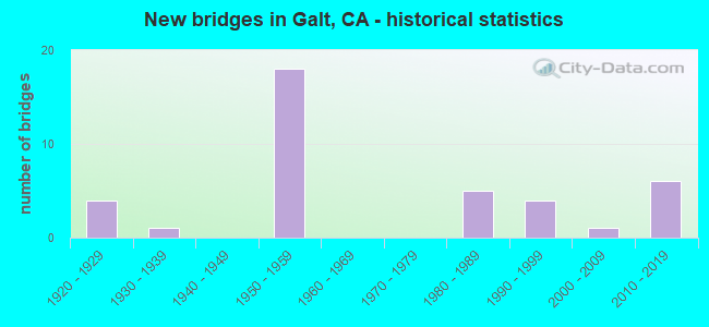
- New bridges - historical statistics
- 41920-1929
- 11930-1939
- 181950-1959
- 51980-1989
- 41990-1999
- 12000-2009
- 62010-2019

- Reconstructed bridges - Historical Statistics
- 41950-1959
- 01960-1969
- 01970-1979
- 61980-1989


- Bridge Condition - Deck
- 55.6%Good
- 18.5%Satisfactory
- 25.9%Fair

- Bridge Condition - Superstructure
- 69.0%Good
- 24.1%Satisfactory
- 6.9%Fair

- Bridge Condition - Substructure
- 79.3%Good
- 17.2%Satisfactory
- 3.4%Fair

- Bridge Condition - Channel
- 20.8%Very good
- 25.0%Good
- 50.0%Satisfactory
- 4.2%Poor

- Bridge Condition - Culverts
- 33.3%Good
- 66.7%Poor
Find on map >> Show street view
Structure Number: 24 0027, Location: 03-SAC-099-5.06 (Lat: 38.311947, Lng: -121.321561), Route carried "on" structure: State highway 99, Year Built: 1958, Year Reconstructed: 2022, Status: Open, Structure Length: 2.87m (9.42ft), Average Daily Traffic: 31,500 (year 2009), Truck Traffic: 18%, Average Future Daily Traffic: 55,865 (year 2040), Design Load: HS 20, Features Intersected: NORTH LAGOON CREEK
Minimum Vertical Clearance: 30+ m (98+ ft), Kilometerpoint: 5.060, Lanes on structure: 4, Base Highway Network: Yes (, Subroute: 1), Owner: State Highway Agency, Approaching Roadway Width: 11.9m (39.0ft), Skew: 32 degrees, Material/Design: Concrete continuous, Design/Construction: Slab, Number Of Spans In Main Unit: 3, Length of Maximum Span: 13.3m (43.6ft), Curb-To-Curb Width: 34.1m (111.9ft), Out-to-Out Width: 35.8m (117.5ft)
Condition: Deck: Fair, Superstructure: Fair, Substructure: Good, Channel: Satisfactory, Operating Rating: 54.1 metric tons, Method Used To Determine Operating Rating: Assigned rating based on Load Factor Design (LFD) reported in metric tons, Inventory Rating: 32.4 metric tons, Method Used To Determine Inventory Rating: Assigned rating based on Load Factor Design (LFD) reported in metric tons, Structural Evaluation: Somewhat better than minimum adequacy, Deck Geometry: Superior to present desirable criteria, Waterway Adequacy: Better than present minimum criteria, Approach Roadway Alignment: Equal to present desirable criteria, Designated Inspection Frequency: Every 24 months, Inspection Date: January 2022, Deck Structure Type: Concrete Precast Panels
Find on map >> Show street view
Structure Number: 24 0027L, Location: 03-SAC-099-5.06 (Lat: 38.311958, Lng: -121.321844), Route carried "on" structure: State highway 99, Year Built: 1928, Year Reconstructed: 1958, Status: Open, Structure Length: 2.74m (8.99ft), Average Daily Traffic: 31,500 (year 2009), Truck Traffic: 18%, Average Future Daily Traffic: 55,865 (year 2040), Design Load: HS 20, Features Intersected: NORTH LAGOON CREEK
Minimum Vertical Clearance: 30+ m (98+ ft), Kilometerpoint: 5.060, Lanes on structure: 2, Base Highway Network: Yes (, Subroute: 1), Owner: State Highway Agency, Approaching Roadway Width: 11.2m (36.7ft), Material/Design: Concrete, Design/Construction: Tee Beam, Number Of Spans In Main Unit: 3, Length of Maximum Span: 9.1m (29.9ft), Curb-To-Curb Width: 11.2m (36.7ft), Out-to-Out Width: 11.4m (37.4ft)
Condition: Deck: Good, Superstructure: Satisfactory, Substructure: Satisfactory, Channel: Satisfactory, Operating Rating: 33.4 metric tons, Method Used To Determine Operating Rating: Load and Resistance Factor Rating (LRFR) rating reported by rating factor(RF) method using HL-93 loadings, Inventory Rating: 25.9 metric tons, Method Used To Determine Inventory Rating: Load and Resistance Factor Rating (LRFR) rating reported by rating factor(RF) method using HL-93 loadings, Structural Evaluation: Equal to present minimum criteria, Deck Geometry: Equal to present minimum criteria, Waterway Adequacy: Better than present minimum criteria, Approach Roadway Alignment: Equal to present desirable criteria, Designated Inspection Frequency: Every 24 months, Inspection Date: January 2022, Deck Structure Type: Concrete Cast-file-Place, Wearing Surface/Protective System: Wearing Surface: Bituminous
Find on map >> Show street view
Structure Number: 24 0028, Location: 03-SAC-099-4.91 (Lat: 38.309975, Lng: -121.320756), Route carried "on" structure: State highway 99, Year Built: 1958, Year Reconstructed: 2022, Status: Open, Structure Length: 2.87m (9.42ft), Average Daily Traffic: 31,500 (year 2009), Truck Traffic: 18%, Average Future Daily Traffic: 55,865 (year 2040), Design Load: HS 20, Features Intersected: SOUTH LAGOON CREEK
Minimum Vertical Clearance: 30+ m (98+ ft), Kilometerpoint: 4.910, Lanes on structure: 4, Base Highway Network: Yes (, Subroute: 1), Owner: State Highway Agency, Approaching Roadway Width: 17.1m (56.1ft), Skew: 32 degrees, Material/Design: Concrete continuous, Design/Construction: Slab, Number Of Spans In Main Unit: 3, Length of Maximum Span: 13.3m (43.6ft), Curb-To-Curb Width: 34.1m (111.9ft), Out-to-Out Width: 35.8m (117.5ft)
Condition: Deck: Good, Superstructure: Good, Substructure: Good, Channel: Satisfactory, Operating Rating: 29.2 metric tons, Method Used To Determine Operating Rating: Load and Resistance Factor Rating (LRFR) rating reported by rating factor(RF) method using HL-93 loadings, Inventory Rating: 22.7 metric tons, Method Used To Determine Inventory Rating: Load and Resistance Factor Rating (LRFR) rating reported by rating factor(RF) method using HL-93 loadings, Structural Evaluation: Somewhat better than minimum adequacy, Deck Geometry: Superior to present desirable criteria, Waterway Adequacy: Better than present minimum criteria, Approach Roadway Alignment: Equal to present desirable criteria, Designated Inspection Frequency: Every 24 months, Inspection Date: January 2022, Deck Structure Type: Concrete Precast Panels
Find on map >> Show street view
Structure Number: 24 0028L, Location: 03-SAC-099-4.91 (Lat: 38.309986, Lng: -121.321042), Route carried "on" structure: State highway 99, Year Built: 1928, Year Reconstructed: 1958, Status: Open, Structure Length: 2.74m (8.99ft), Average Daily Traffic: 31,500 (year 2009), Truck Traffic: 18%, Average Future Daily Traffic: 55,865 (year 2040), Features Intersected: SOUTH LAGOON CREEK
Minimum Vertical Clearance: 30+ m (98+ ft), Kilometerpoint: 4.910, Lanes on structure: 2, Base Highway Network: Yes (, Subroute: 1), Owner: State Highway Agency, Approaching Roadway Width: 11.0m (36.1ft), Material/Design: Concrete, Design/Construction: Tee Beam, Number Of Spans In Main Unit: 3, Length of Maximum Span: 9.1m (29.9ft), Curb-To-Curb Width: 11.0m (36.1ft), Out-to-Out Width: 11.6m (38.1ft)
Condition: Deck: Good, Superstructure: Good, Substructure: Good, Channel: Satisfactory, Operating Rating: 35.3 metric tons, Method Used To Determine Operating Rating: Field evaluation and documented engineering judgment, Inventory Rating: 21.4 metric tons, Method Used To Determine Inventory Rating: Field evaluation and documented engineering judgment, Structural Evaluation: Somewhat better than minimum adequacy, Deck Geometry: Equal to present minimum criteria, Waterway Adequacy: Better than present minimum criteria, Approach Roadway Alignment: Equal to present desirable criteria, Designated Inspection Frequency: Every 24 months, Inspection Date: January 2022, Deck Structure Type: Concrete Cast-file-Place, Wearing Surface/Protective System: Wearing Surface: Bituminous
Find on map >> Show street view
Structure Number: 24 0029, Location: 03-SAC-099-2.36 (Lat: 38.275447, Lng: -121.304017), Route carried "on" structure: State highway 99, Year Built: 1958, Status: Open, Structure Length: 0.67m (2.20ft), Average Daily Traffic: 58,000 (year 2002), Truck Traffic: 18%, Average Future Daily Traffic: 97,912 (year 2042), Features Intersected: LOG CABIN CREEK
Minimum Vertical Clearance: 30+ m (98+ ft), Kilometerpoint: 2.360, Lanes on structure: 4, Base Highway Network: Yes (, Subroute: 1), Owner: State Highway Agency, Approaching Roadway Width: 47.2m (154.9ft), Material/Design: Concrete continuous, Design/Construction: Culvert, Number Of Spans In Main Unit: 2, Length of Maximum Span: 3.0m (9.8ft)
Condition: Channel: Satisfactory, Culverts: Poor, Operating Rating: 54.1 metric tons, Method Used To Determine Operating Rating: Field evaluation and documented engineering judgment, Inventory Rating: 32.4 metric tons, Method Used To Determine Inventory Rating: Field evaluation and documented engineering judgment, Structural Evaluation: Meets minimum limits, Waterway Adequacy: Equal to present minimum criteria, Approach Roadway Alignment: Equal to present desirable criteria, Designated Inspection Frequency: Every 24 months, Inspection Date: January 2022
Find on map >> Show street view
Structure Number: 24 0030R, Location: 03-SAC-099-0.13-GAL (Lat: 38.245694, Lng: -121.287811), Route carried "on" structure: State highway 99, Year Built: 1955, Year Reconstructed: 1992, Status: Open, Structure Length: 5.21m (17.09ft), Average Daily Traffic: 29,500 (year 2009), Truck Traffic: 15%, Average Future Daily Traffic: 54,299 (year 2040), Design Load: HS 20, Features Intersected: NORTH CHANNEL DRY CREEK
Minimum Vertical Clearance: 30+ m (98+ ft), Kilometerpoint: 0.130, Lanes on structure: 2, Base Highway Network: Yes (, Subroute: 1), Owner: State Highway Agency, Approaching Roadway Width: 11.9m (39.0ft), Skew: 3 degrees, Material/Design: Concrete continuous, Design/Construction: Slab, Number Of Spans In Main Unit: 8, Length of Maximum Span: 7.1m (23.3ft), Curb-To-Curb Width: 11.9m (39.0ft), Out-to-Out Width: 13.0m (42.7ft)
Condition: Deck: Satisfactory, Superstructure: Satisfactory, Substructure: Good, Channel: Satisfactory, Operating Rating: 52.5 metric tons, Method Used To Determine Operating Rating: Load Factor (LF), Inventory Rating: 31.4 metric tons, Method Used To Determine Inventory Rating: Load Factor (LF), Structural Evaluation: Equal to present minimum criteria, Deck Geometry: Equal to present minimum criteria, Waterway Adequacy: Equal to present minimum criteria, Approach Roadway Alignment: Equal to present desirable criteria, Designated Inspection Frequency: Every 24 months, Inspection Date: January 2022, Deck Structure Type: Concrete Cast-file-Place
Find on map >> Show street view
Structure Number: 24 0045, Location: 03-SAC-099-4.98 (Lat: 38.310872, Lng: -121.321119), Route carried "on" structure: State highway 99, Year Built: 1958, Year Reconstructed: 1993, Status: Open, Structure Length: 5.49m (18.01ft), Average Daily Traffic: 31,500 (year 2009), Truck Traffic: 18%, Average Future Daily Traffic: 55,865 (year 2040), Design Load: HS 20, Features Intersected: LAGOON CREEK
Minimum Vertical Clearance: 30+ m (98+ ft), Kilometerpoint: 4.980, Lanes on structure: 4, Base Highway Network: Yes (, Subroute: 1), Owner: State Highway Agency, Approaching Roadway Width: 17.1m (56.1ft), Skew: 32 degrees, Material/Design: Concrete continuous, Design/Construction: Slab, Number Of Spans In Main Unit: 6, Length of Maximum Span: 18.3m (60.0ft), Curb-To-Curb Width: 34.1m (111.9ft), Out-to-Out Width: 35.7m (117.1ft)
Condition: Deck: Satisfactory, Superstructure: Satisfactory, Substructure: Fair, Channel: Satisfactory, Operating Rating: 54.1 metric tons, Method Used To Determine Operating Rating: Assigned rating based on Load Factor Design (LFD) reported in metric tons, Inventory Rating: 32.4 metric tons, Method Used To Determine Inventory Rating: Assigned rating based on Load Factor Design (LFD) reported in metric tons, Structural Evaluation: Somewhat better than minimum adequacy, Deck Geometry: Superior to present desirable criteria, Waterway Adequacy: Better than present minimum criteria, Approach Roadway Alignment: Equal to present desirable criteria, Designated Inspection Frequency: Every 24 months, Inspection Date: January 2022, Deck Structure Type: Concrete Cast-file-Place
Find on map >> Show street view
Structure Number: 24 0045L, Location: 03-SAC-099-4.98 (Lat: 38.310886, Lng: -121.321417), Route carried "on" structure: State highway 99, Year Built: 1928, Year Reconstructed: 1958, Status: Open, Structure Length: 5.49m (18.01ft), Average Daily Traffic: 31,500 (year 2009), Truck Traffic: 18%, Average Future Daily Traffic: 55,865 (year 2040), Features Intersected: LAGOON CREEK
Minimum Vertical Clearance: 30+ m (98+ ft), Kilometerpoint: 4.980, Lanes on structure: 2, Base Highway Network: Yes (, Subroute: 1), Owner: State Highway Agency, Approaching Roadway Width: 11.0m (36.1ft), Material/Design: Concrete, Design/Construction: Tee Beam, Number Of Spans In Main Unit: 6, Length of Maximum Span: 9.1m (29.9ft), Curb-To-Curb Width: 11.0m (36.1ft), Out-to-Out Width: 11.2m (36.7ft)
Condition: Deck: Good, Superstructure: Satisfactory, Substructure: Satisfactory, Channel: Good, Operating Rating: 35.3 metric tons, Method Used To Determine Operating Rating: Field evaluation and documented engineering judgment, Inventory Rating: 21.4 metric tons, Method Used To Determine Inventory Rating: Field evaluation and documented engineering judgment, Structural Evaluation: Somewhat better than minimum adequacy, Deck Geometry: Equal to present minimum criteria, Waterway Adequacy: Equal to present minimum criteria, Approach Roadway Alignment: Equal to present desirable criteria, Designated Inspection Frequency: Every 24 months, Inspection Date: January 2022, Deck Structure Type: Concrete Cast-file-Place, Wearing Surface/Protective System: Wearing Surface: Bituminous
Find on map >> Show street view
Structure Number: 24 0046L, Location: 03-SAC-099-6.54 (Lat: 38.332317, Lng: -121.330628), Route carried "on" structure: State highway 99, Year Built: 1927, Year Reconstructed: 1958, Status: Open, Structure Length: 1.91m (6.27ft), Average Daily Traffic: 31,500 (year 2009), Truck Traffic: 18%, Average Future Daily Traffic: 55,865 (year 2040), Features Intersected: WILLOW SLOUGH
Minimum Vertical Clearance: 30+ m (98+ ft), Kilometerpoint: 6.540, Lanes on structure: 2, Base Highway Network: Yes (, Subroute: 1), Owner: State Highway Agency, Approaching Roadway Width: 11.7m (38.4ft), Material/Design: Concrete, Design/Construction: Tee Beam, Number Of Spans In Main Unit: 3, Length of Maximum Span: 6.1m (20.0ft), Curb-To-Curb Width: 11.7m (38.4ft), Out-to-Out Width: 11.9m (39.0ft)
Condition: Deck: Good, Superstructure: Satisfactory, Substructure: Satisfactory, Channel: Good, Operating Rating: 40.5 metric tons, Method Used To Determine Operating Rating: Field evaluation and documented engineering judgment, Inventory Rating: 24.3 metric tons, Method Used To Determine Inventory Rating: Field evaluation and documented engineering judgment, Structural Evaluation: Equal to present minimum criteria, Deck Geometry: Better than present minimum criteria, Waterway Adequacy: Equal to present desirable criteria, Approach Roadway Alignment: Equal to present desirable criteria, Designated Inspection Frequency: Every 24 months, Inspection Date: January 2022, Deck Structure Type: Concrete Cast-file-Place, Wearing Surface/Protective System: Wearing Surface: Bituminous
Find on map >> Show street view
Structure Number: 24 0046R, Location: 03-SAC-099-6.54 (Lat: 38.332386, Lng: -121.330369), Route carried "on" structure: State highway 99, Year Built: 1958, Year Reconstructed: 1993, Status: Open, Structure Length: 1.92m (6.30ft), Average Daily Traffic: 31,500 (year 2009), Truck Traffic: 18%, Average Future Daily Traffic: 55,865 (year 2040), Design Load: HS 20, Features Intersected: WILLOW SLOUGH
Minimum Vertical Clearance: 30+ m (98+ ft), Kilometerpoint: 6.540, Lanes on structure: 2, Base Highway Network: Yes (, Subroute: 1), Owner: State Highway Agency, Approaching Roadway Width: 11.9m (39.0ft), Material/Design: Concrete continuous, Design/Construction: Slab, Number Of Spans In Main Unit: 3, Length of Maximum Span: 6.1m (20.0ft), Curb-To-Curb Width: 11.9m (39.0ft), Out-to-Out Width: 12.8m (42.0ft)
Condition: Deck: Satisfactory, Superstructure: Satisfactory, Substructure: Satisfactory, Channel: Satisfactory, Operating Rating: 49.6 metric tons, Method Used To Determine Operating Rating: Load Factor (LF), Inventory Rating: 29.8 metric tons, Method Used To Determine Inventory Rating: Load Factor (LF), Structural Evaluation: Equal to present minimum criteria, Deck Geometry: Better than present minimum criteria, Waterway Adequacy: Equal to present desirable criteria, Approach Roadway Alignment: Equal to present desirable criteria, Length Of Structure Improvement: 1.92m (6.30ft), Designated Inspection Frequency: Every 24 months, Inspection Date: January 2022, Deck Structure Type: Concrete Cast-file-Place
Find on map >> Show street view
Structure Number: 24 0130L, Location: 03-SAC-051-3.63-SAC (Lat: 38.599853, Lng: -121.440467), Route carried "on" structure: State highway 51, Year Built: 1954, Year Reconstructed: 1994, Status: Open, Structure Length: 8.46m (27.76ft), Average Daily Traffic: 100,000 (year 2010), Truck Traffic: 6%, Average Future Daily Traffic: 124,513 (year 2039), Design Load: HS 20, Features Intersected: STATE ROUTE 160 NB
Minimum Vertical Clearance: 30+ m (98+ ft), Kilometerpoint: 3.630, Lanes on structure: 4, Lanes under structure: 2, Base Highway Network: Yes (, Subroute: 1), Owner: State Highway Agency, Approaching Roadway Width: 19.2m (63.0ft), Material/Design: Concrete continuous, Design/Construction: Box Beam or Girders - Multiple, Number Of Spans In Main Unit: 3, Length of Maximum Span: 39.6m (129.9ft), Curb-To-Curb Width: 19.2m (63.0ft), Out-to-Out Width: 20.0m (65.6ft)
Condition: Deck: Good, Superstructure: Good, Substructure: Good, Operating Rating: 79.1 metric tons, Method Used To Determine Operating Rating: Load Factor (LF), Inventory Rating: 47.6 metric tons, Method Used To Determine Inventory Rating: Load Factor (LF), Structural Evaluation: Better than present minimum criteria, Deck Geometry: Somewhat better than minimum adequacy, Underclear: High priority of corrective action, Approach Roadway Alignment: Equal to present desirable criteria, Designated Inspection Frequency: Every 24 months, Inspection Date: November 2021, Deck Structure Type: Concrete Cast-file-Place, Wearing Surface/Protective System: Wearing Surface: Integral Concrete
Find on map >> Show street view
Structure Number: 24 0138, Location: 03-SAC-099-1.57-GAL (Lat: 38.264297, Lng: -121.300164), Route carried "on" structure: City street , Year Built: 1958, Status: Open, Structure Length: 5.94m (19.49ft), Average Daily Traffic: 1,400 (year 2003), Truck Traffic: 2%, Average Future Daily Traffic: 5,379 (year 2042), Design Load: HS 20, Features Intersected: STATE ROUTE 99, Facility Carried by Structure: SIMMERHORN ROAD
Minimum Vertical Clearance: 30+ m (98+ ft), Kilometerpoint: 0.000, Lanes on structure: 2, Lanes under structure: 4, Owner: State Highway Agency, Approaching Roadway Width: 8.5m (27.9ft), Material/Design: Concrete continuous, Design/Construction: Tee Beam, Number Of Spans In Main Unit: 2, Number Of Approach Spans: 2, Length of Maximum Span: 18.0m (59.1ft), Curb or Sidewalk Widths: Left: 1.6m (5.2ft), Right: 0.6m (2.0ft), Curb-To-Curb Width: 8.5m (27.9ft), Out-to-Out Width: 11.3m (37.1ft)
Condition: Deck: Fair, Superstructure: Good, Substructure: Good, Operating Rating: 25.9 metric tons, Method Used To Determine Operating Rating: Load and Resistance Factor Rating (LRFR) rating reported by rating factor(RF) method using HL-93 loadings, Inventory Rating: 20.1 metric tons, Method Used To Determine Inventory Rating: Load and Resistance Factor Rating (LRFR) rating reported by rating factor(RF) method using HL-93 loadings, Structural Evaluation: Somewhat better than minimum adequacy, Deck Geometry: Somewhat better than minimum adequacy, Underclear: High priority of corrective action, Approach Roadway Alignment: Equal to present desirable criteria, Designated Inspection Frequency: Every 24 months, Inspection Date: January 2022, Deck Structure Type: Concrete Cast-file-Place
Find on map >> Show street view
Structure Number: 24 0139, Location: 03-SAC-099-1.62-GAL (Lat: 38.265067, Lng: -121.300581), Route carried "on" structure: City street , Year Built: 1958, Status: Open, Structure Length: 3.66m (12.01ft), Average Daily Traffic: 1,700 (year 2003), Truck Traffic: 2%, Average Future Daily Traffic: 5,379 (year 2042), Design Load: HS 20, Features Intersected: STATE ROUTE 99, Facility Carried by Structure: AMADOR AVE
Minimum Vertical Clearance: 30+ m (98+ ft), Kilometerpoint: 0.000, Lanes on structure: 2, Lanes under structure: 4, Owner: State Highway Agency, Approaching Roadway Width: 8.5m (27.9ft), Skew: 1 degrees, Material/Design: Concrete continuous, Design/Construction: Tee Beam, Number Of Spans In Main Unit: 2, Length of Maximum Span: 18.3m (60.0ft), Curb or Sidewalk Widths: Left: 1.6m (5.2ft), Right: 0.6m (2.0ft), Curb-To-Curb Width: 8.5m (27.9ft), Out-to-Out Width: 11.2m (36.7ft)
Condition: Deck: Satisfactory, Superstructure: Good, Substructure: Good, Operating Rating: 42.1 metric tons, Method Used To Determine Operating Rating: Load and Resistance Factor Rating (LRFR) rating reported by rating factor(RF) method using HL-93 loadings, Inventory Rating: 30.1 metric tons, Method Used To Determine Inventory Rating: Load and Resistance Factor Rating (LRFR) rating reported by rating factor(RF) method using HL-93 loadings, Structural Evaluation: Better than present minimum criteria, Deck Geometry: Somewhat better than minimum adequacy, Underclear: Meets minimum limits, Approach Roadway Alignment: Equal to present desirable criteria, Designated Inspection Frequency: Every 24 months, Inspection Date: January 2022, Deck Structure Type: Concrete Cast-file-Place
Find on map >> Show street view
Structure Number: 24 0144, Location: 03-SAC-104-0.01 (Lat: 38.291042, Lng: -121.312650), Route carried "on" structure: State highway 104, Year Built: 1958, Status: Open, Structure Length: 6.37m (20.90ft), Average Daily Traffic: 8,000 (year 2010), Truck Traffic: 6%, Average Future Daily Traffic: 8,677 (year 2040), Design Load: HS 20, Features Intersected: STATE ROUTE 99
Minimum Vertical Clearance: 30+ m (98+ ft), Kilometerpoint: 0.010, Lanes on structure: 2, Lanes under structure: 4, Owner: State Highway Agency, Approaching Roadway Width: 8.5m (27.9ft), Skew: 2 degrees, Material/Design: Concrete continuous, Design/Construction: Tee Beam, Number Of Spans In Main Unit: 4, Length of Maximum Span: 19.8m (65.0ft), Curb or Sidewalk Widths: Left: 1.6m (5.2ft), Right: 0.6m (2.0ft), Curb-To-Curb Width: 8.5m (27.9ft), Out-to-Out Width: 10.9m (35.8ft)
Condition: Deck: Fair, Superstructure: Good, Substructure: Good, Operating Rating: 36.9 metric tons, Method Used To Determine Operating Rating: Load and Resistance Factor Rating (LRFR) rating reported by rating factor(RF) method using HL-93 loadings, Inventory Rating: 28.5 metric tons, Method Used To Determine Inventory Rating: Load and Resistance Factor Rating (LRFR) rating reported by rating factor(RF) method using HL-93 loadings, Structural Evaluation: Better than present minimum criteria, Deck Geometry: Meets minimum limits, Underclear: Meets minimum limits, Approach Roadway Alignment: Equal to present desirable criteria, Designated Inspection Frequency: Every 24 months, Inspection Date: March 2021, Deck Structure Type: Concrete Cast-file-Place, Wearing Surface/Protective System: Wearing Surface: Bituminous
Find on map >> Show street view
Structure Number: 24 0151, Location: 03-SAC-099-6.01 (Lat: 38.324919, Lng: -121.327497), Route carried "on" structure: County highway , Year Built: 1958, Status: Open, Structure Length: 5.30m (17.39ft), Average Daily Traffic: 840 (year 1998), Truck Traffic: 2%, Average Future Daily Traffic: 1,362 (year 2044), Design Load: HS 20, Features Intersected: STATE ROUTE 99, Facility Carried by Structure: ARNO ROAD
Minimum Vertical Clearance: 30+ m (98+ ft), Kilometerpoint: 0.000, Lanes on structure: 2, Lanes under structure: 4, Owner: State Highway Agency, Approaching Roadway Width: 8.5m (27.9ft), Material/Design: Prestressed concrete, Design/Construction: Tee Beam, Number Of Spans In Main Unit: 2, Number Of Approach Spans: 2, Length of Maximum Span: 18.0m (59.1ft), Curb or Sidewalk Widths: Left: 1.4m (4.6ft), Right: 0.7m (2.3ft), Curb-To-Curb Width: 8.5m (27.9ft), Out-to-Out Width: 11.0m (36.1ft)
Condition: Deck: Fair, Superstructure: Satisfactory, Substructure: Satisfactory, Operating Rating: 32.1 metric tons, Method Used To Determine Operating Rating: Load and Resistance Factor Rating (LRFR) rating reported by rating factor(RF) method using HL-93 loadings, Inventory Rating: 25.9 metric tons, Method Used To Determine Inventory Rating: Load and Resistance Factor Rating (LRFR) rating reported by rating factor(RF) method using HL-93 loadings, Structural Evaluation: Equal to present minimum criteria, Deck Geometry: Somewhat better than minimum adequacy, Underclear: Meets minimum limits, Approach Roadway Alignment: Equal to present desirable criteria, Designated Inspection Frequency: Every 24 months, Inspection Date: January 2022, Deck Structure Type: Concrete Cast-file-Place, Wearing Surface/Protective System: Wearing Surface: Bituminous
Find on map >> Show street view
Structure Number: 24 037, Location: 03-SAC-099-35.37 (Lat: 38.714217, Lng: -121.540839), Route carried "on" structure: County highway , Year Built: 2013, Status: Open, Structure Length: 8.29m (27.20ft), Average Daily Traffic: 6,000 (year 2013), Truck Traffic: 3%, Average Future Daily Traffic: 8,189 (year 2041), Design Load: HL 93, Features Intersected: STATE ROUTE 99, Facility Carried by Structure: WEST ELVERTA ROAD
Minimum Vertical Clearance: 30+ m (98+ ft), Kilometerpoint: 0.000, Lanes on structure: 4, Lanes under structure: 6, Base Highway Network: Yes, Owner: State Highway Agency, Approaching Roadway Width: 20.9m (68.6ft), Material/Design: Prestressed concrete continuous, Design/Construction: Box Beam or Girders - Multiple, Number Of Spans In Main Unit: 2, Length of Maximum Span: 41.4m (135.8ft), Curb or Sidewalk Widths: Left: 2.0m (6.6ft), Right: 2.0m (6.6ft), Curb-To-Curb Width: 20.9m (68.6ft), Out-to-Out Width: 25.5m (83.7ft)
Condition: Deck: Satisfactory, Superstructure: Good, Substructure: Good, Operating Rating: 42.1 metric tons, Method Used To Determine Operating Rating: Assigned ratings based on Load and Resistance Factor Design (LRFD) reported by rating factor (RF) using HL93 loadings, Inventory Rating: 32.4 metric tons, Method Used To Determine Inventory Rating: Assigned ratings based on Load and Resistance Factor Design (LRFD) reported by rating factor (RF) using HL93 loadings, Structural Evaluation: Better than present minimum criteria, Deck Geometry: Superior to present desirable criteria, Underclear: Meets minimum limits, Approach Roadway Alignment: Equal to present desirable criteria, Designated Inspection Frequency: Every 24 months, Inspection Date: June 2021, Deck Structure Type: Concrete Cast-file-Place
Find on map >> Show street view
Structure Number: 24 0378, Location: 03-SAC-099-0.88-GAL (Lat: 38.255144, Lng: -121.294558), Route carried "on" structure: City street , Year Built: 2012, Status: Open, Structure Length: 6.15m (20.18ft), Average Daily Traffic: 8,500 (year 2012), Truck Traffic: 3%, Average Future Daily Traffic: 9,182 (year 2040), Design Load: HL 93, Features Intersected: STATE ROUTE 99, Facility Carried by Structure: A ST - CRYSTAL WAY
Minimum Vertical Clearance: 30+ m (98+ ft), Kilometerpoint: 0.000, Lanes on structure: 6, Lanes under structure: 4, Owner: State Highway Agency, Approaching Roadway Width: 27.0m (88.6ft), Material/Design: Prestressed concrete continuous, Design/Construction: Box Beam or Girders - Multiple, Number Of Spans In Main Unit: 2, Length of Maximum Span: 31.3m (102.7ft), Curb or Sidewalk Widths: Left: 1.5m (4.9ft), Right: 1.5m (4.9ft), Curb-To-Curb Width: 27.0m (88.6ft), Out-to-Out Width: 30.6m (100.4ft)
Condition: Deck: Fair, Superstructure: Good, Substructure: Good, Operating Rating: 42.1 metric tons, Method Used To Determine Operating Rating: Assigned ratings based on Load and Resistance Factor Design (LRFD) reported by rating factor (RF) using HL93 loadings, Inventory Rating: 32.4 metric tons, Method Used To Determine Inventory Rating: Assigned ratings based on Load and Resistance Factor Design (LRFD) reported by rating factor (RF) using HL93 loadings, Structural Evaluation: Better than present minimum criteria, Deck Geometry: Better than present minimum criteria, Underclear: Equal to present minimum criteria, Approach Roadway Alignment: Equal to present minimum criteria, Designated Inspection Frequency: Every 24 months, Inspection Date: January 2022, Deck Structure Type: Concrete Cast-file-Place
Find on map >> Show street view
Structure Number: 24 0379, Location: 03-SAC-099-0.80-GAL (Lat: 38.254267, Lng: -121.293833), Route carried "on" structure: City street , Year Built: 2012, Status: Open, Structure Length: 6.21m (20.37ft), Average Daily Traffic: 5,000 (year 2012), Truck Traffic: 3%, Average Future Daily Traffic: 6,244 (year 2042), Design Load: HL 93, Features Intersected: STATE ROUTE 99, Facility Carried by Structure: C ST - BOESSOW RD
Minimum Vertical Clearance: 30+ m (98+ ft), Kilometerpoint: 0.000, Lanes on structure: 6, Lanes under structure: 4, Owner: State Highway Agency, Approaching Roadway Width: 27.6m (90.6ft), Skew: 1 degrees, Material/Design: Prestressed concrete continuous, Design/Construction: Box Beam or Girders - Multiple, Number Of Spans In Main Unit: 2, Length of Maximum Span: 31.4m (103.0ft), Curb or Sidewalk Widths: Left: 1.5m (4.9ft), Right: 1.5m (4.9ft), Curb-To-Curb Width: 27.6m (90.6ft), Out-to-Out Width: 31.2m (102.4ft)
Condition: Deck: Fair, Superstructure: Good, Substructure: Good, Operating Rating: 42.1 metric tons, Method Used To Determine Operating Rating: Assigned ratings based on Load and Resistance Factor Design (LRFD) reported by rating factor (RF) using HL93 loadings, Inventory Rating: 32.4 metric tons, Method Used To Determine Inventory Rating: Assigned ratings based on Load and Resistance Factor Design (LRFD) reported by rating factor (RF) using HL93 loadings, Structural Evaluation: Better than present minimum criteria, Deck Geometry: Better than present minimum criteria, Underclear: Equal to present minimum criteria, Approach Roadway Alignment: Equal to present minimum criteria, Designated Inspection Frequency: Every 24 months, Inspection Date: January 2022, Deck Structure Type: Concrete Cast-file-Place
Find on map >> Show street view
Structure Number: 24C0166, Location: 2.3 MI W CHRISTENSEN RD (Lat: 38.290744, Lng: -121.381939), Route carried "on" structure: County highway , Year Built: 1983, Status: Open, Structure Length: 13.78m (45.21ft), Average Daily Traffic: 4,223 (year 2009), Truck Traffic: 10%, Average Future Daily Traffic: 5,183 (year 2039), Design Load: HS 20+Mod, Features Intersected: COSUMNES RIVER OVERFLOW, Facility Carried by Structure: TWIN CITIES RD
Minimum Vertical Clearance: 30+ m (98+ ft), Kilometerpoint: 0.000, Lanes on structure: 2, Owner: County Highway Agency, Approaching Roadway Width: 10.7m (35.1ft), Material/Design: Concrete continuous, Design/Construction: Slab, Number Of Spans In Main Unit: 15, Length of Maximum Span: 9.1m (29.9ft), Curb-To-Curb Width: 11.0m (36.1ft), Out-to-Out Width: 11.2m (36.7ft)
Condition: Deck: Good, Superstructure: Good, Substructure: Good, Channel: Satisfactory, Operating Rating: 61.6 metric tons, Method Used To Determine Operating Rating: Load Factor (LF), Inventory Rating: 36.9 metric tons, Method Used To Determine Inventory Rating: Load Factor (LF), Structural Evaluation: Better than present minimum criteria, Deck Geometry: Somewhat better than minimum adequacy, Waterway Adequacy: Superior to present desirable criteria, Approach Roadway Alignment: Equal to present desirable criteria, Designated Inspection Frequency: Every 48 months, Inspection Date: October 2018, Deck Structure Type: Concrete Cast-file-Place, Wearing Surface/Protective System: Wearing Surface: Bituminous
Find on map >> Show street view
Structure Number: 24C018, Location: 2.1 MI W CHRISTENSEN RD (Lat: 38.290756, Lng: -121.377414), Route carried "on" structure: County highway , Year Built: 1983, Status: Open, Structure Length: 13.78m (45.21ft), Average Daily Traffic: 4,286 (year 2009), Truck Traffic: 10%, Average Future Daily Traffic: 5,271 (year 2039), Design Load: HS 20+Mod, Features Intersected: LAGUNA CREEK, Facility Carried by Structure: TWIN CITIES RD
Minimum Vertical Clearance: 30+ m (98+ ft), Kilometerpoint: 0.000, Lanes on structure: 2, Owner: County Highway Agency, Approaching Roadway Width: 10.7m (35.1ft), Material/Design: Concrete continuous, Design/Construction: Slab, Number Of Spans In Main Unit: 15, Length of Maximum Span: 9.1m (29.9ft), Curb-To-Curb Width: 11.0m (36.1ft), Out-to-Out Width: 11.2m (36.7ft)
Condition: Deck: Good, Superstructure: Good, Substructure: Good, Channel: Good, Operating Rating: 61.6 metric tons, Method Used To Determine Operating Rating: Load Factor (LF), Inventory Rating: 36.9 metric tons, Method Used To Determine Inventory Rating: Load Factor (LF), Structural Evaluation: Better than present minimum criteria, Deck Geometry: Somewhat better than minimum adequacy, Waterway Adequacy: Superior to present desirable criteria, Approach Roadway Alignment: Equal to present desirable criteria, Designated Inspection Frequency: Every 48 months, Inspection Date: October 2018, Deck Structure Type: Concrete Cast-file-Place, Wearing Surface/Protective System: Wearing Surface: Bituminous
Find on map >> Show street view
Structure Number: 24C0182, Location: 2.75 MI W CHRISTENSEN RD (Lat: 38.290697, Lng: -121.387822), Route carried "on" structure: County highway , Year Built: 1983, Status: Open, Structure Length: 5.55m (18.21ft), Average Daily Traffic: 4,285 (year 2009), Truck Traffic: 10%, Average Future Daily Traffic: 5,271 (year 2039), Design Load: HS 20+Mod, Features Intersected: COSUMNES RIVER OVERFLOW, Facility Carried by Structure: TWIN CITIES RD
Minimum Vertical Clearance: 30+ m (98+ ft), Kilometerpoint: 0.000, Lanes on structure: 2, Owner: County Highway Agency, Approaching Roadway Width: 10.7m (35.1ft), Material/Design: Concrete continuous, Design/Construction: Slab, Number Of Spans In Main Unit: 6, Length of Maximum Span: 9.1m (29.9ft), Curb-To-Curb Width: 11.0m (36.1ft), Out-to-Out Width: 11.2m (36.7ft)
Condition: Deck: Good, Superstructure: Good, Substructure: Good, Channel: Good, Operating Rating: 61.6 metric tons, Method Used To Determine Operating Rating: Load Factor (LF), Inventory Rating: 36.9 metric tons, Method Used To Determine Inventory Rating: Load Factor (LF), Structural Evaluation: Better than present minimum criteria, Deck Geometry: Somewhat better than minimum adequacy, Waterway Adequacy: Superior to present desirable criteria, Approach Roadway Alignment: Equal to present desirable criteria, Designated Inspection Frequency: Every 48 months, Inspection Date: October 2018, Deck Structure Type: Concrete Cast-file-Place, Wearing Surface/Protective System: Wearing Surface: Bituminous
Find on map >> Show street view
Structure Number: 24C0263, Location: 0.9 MI S TWIN CITIES RD (Lat: 38.278422, Lng: -121.337328), Route carried "on" structure: County highway , Year Built: 1986, Status: Open, Structure Length: 2.36m (7.74ft), Average Daily Traffic: 602 (year 2009), Truck Traffic: 10%, Average Future Daily Traffic: 772 (year 2039), Design Load: HS 20+Mod, Features Intersected: DEADMAN GULCH, Facility Carried by Structure: CHRISTENSEN RD
Minimum Vertical Clearance: 30+ m (98+ ft), Kilometerpoint: 0.000, Lanes on structure: 2, Owner: County Highway Agency, Approaching Roadway Width: 6.1m (20.0ft), Material/Design: Concrete continuous, Design/Construction: Slab, Number Of Spans In Main Unit: 3, Length of Maximum Span: 7.6m (24.9ft), Curb-To-Curb Width: 11.1m (36.4ft), Out-to-Out Width: 11.2m (36.7ft)
Condition: Deck: Good, Superstructure: Good, Substructure: Good, Channel: Satisfactory, Operating Rating: 34.0 metric tons, Method Used To Determine Operating Rating: Load and Resistance Factor Rating (LRFR) rating reported by rating factor(RF) method using HL-93 loadings, Inventory Rating: 26.2 metric tons, Method Used To Determine Inventory Rating: Load and Resistance Factor Rating (LRFR) rating reported by rating factor(RF) method using HL-93 loadings, Structural Evaluation: Equal to present minimum criteria, Deck Geometry: Better than present minimum criteria, Waterway Adequacy: Superior to present desirable criteria, Approach Roadway Alignment: Equal to present desirable criteria, Designated Inspection Frequency: Every 24 months, Inspection Date: October 2020, Deck Structure Type: Concrete Cast-file-Place, Wearing Surface/Protective System: Wearing Surface: Bituminous
Find on map >> Show street view
Structure Number: 24C0433, Location: 0.5 MI S TWIN CITIES RD (Lat: 38.282447, Lng: -121.282558), Route carried "on" structure: County highway , Year Built: 1990, Status: Open, Structure Length: 0.76m (2.49ft), Average Daily Traffic: 6,560 (year 2007), Truck Traffic: 3%, Average Future Daily Traffic: 8,337 (year 2042), Features Intersected: DEADMAN GULCH, Facility Carried by Structure: MARENGO RD
Minimum Vertical Clearance: 30+ m (98+ ft), Kilometerpoint: 0.000, Lanes on structure: 4, Owner: City or Municipal Highway Agency, Approaching Roadway Width: 16.8m (55.1ft), Material/Design: Concrete continuous, Design/Construction: Culvert, Number Of Spans In Main Unit: 3, Length of Maximum Span: 2.1m (6.9ft)
Condition: Channel: Good, Culverts: Good, Operating Rating: 54.1 metric tons, Method Used To Determine Operating Rating: Field evaluation and documented engineering judgment, Inventory Rating: 32.4 metric tons, Method Used To Determine Inventory Rating: Field evaluation and documented engineering judgment, Structural Evaluation: Better than present minimum criteria, Waterway Adequacy: Equal to present desirable criteria, Approach Roadway Alignment: Equal to present desirable criteria, Designated Inspection Frequency: Every 48 months, Inspection Date: October 2020
Find on map >> Show street view
Structure Number: 24C0515, Location: 1.8 MI. S OF ARNO ROAD (Lat: 38.298667, Lng: -121.301186), Route carried "on" structure: County highway , Year Built: 1998, Status: Open, Structure Length: 2.40m (7.87ft), Average Daily Traffic: 804 (year 2009), Truck Traffic: 10%, Average Future Daily Traffic: 1,003 (year 2038), Features Intersected: SKUNK CREEK, Facility Carried by Structure: MCKENZIE ROAD
Minimum Vertical Clearance: 30+ m (98+ ft), Kilometerpoint: 0.000, Lanes on structure: 2, Owner: County Highway Agency, Approaching Roadway Width: 10.1m (33.1ft), Material/Design: Concrete continuous, Design/Construction: Slab, Number Of Spans In Main Unit: 3, Length of Maximum Span: 8.0m (26.2ft), Curb-To-Curb Width: 9.3m (30.5ft), Out-to-Out Width: 10.1m (33.1ft)
Condition: Deck: Good, Superstructure: Good, Substructure: Good, Channel: Very good, Operating Rating: 54.1 metric tons, Method Used To Determine Operating Rating: Field evaluation and documented engineering judgment, Inventory Rating: 32.4 metric tons, Method Used To Determine Inventory Rating: Field evaluation and documented engineering judgment, Structural Evaluation: Better than present minimum criteria, Deck Geometry: Equal to present minimum criteria, Waterway Adequacy: Equal to present desirable criteria, Approach Roadway Alignment: Equal to present desirable criteria, Designated Inspection Frequency: Every 48 months, Inspection Date: October 2018, Deck Structure Type: Concrete Cast-file-Place
Find on map >> Show street view
Structure Number: 24C0574, Location: 0.9 MI SOUTH OF ARNO RD (Lat: 38.311806, Lng: -121.301250), Route carried "on" structure: County highway , Year Built: 2019, Status: Open, Structure Length: 6.75m (22.15ft), Average Daily Traffic: 1,298 (year 2017), Truck Traffic: 10%, Average Future Daily Traffic: 1,530 (year 2042), Design Load: HL 93, Features Intersected: LAGUNA CREEK, Facility Carried by Structure: MCKENZIE ROAD
Minimum Vertical Clearance: 30+ m (98+ ft), Kilometerpoint: 0.000, Lanes on structure: 2, Owner: County Highway Agency, Approaching Roadway Width: 11.0m (36.1ft), Material/Design: Concrete continuous, Design/Construction: Slab, Number Of Spans In Main Unit: 5, Length of Maximum Span: 13.4m (44.0ft), Curb-To-Curb Width: 11.0m (36.1ft), Out-to-Out Width: 12.2m (40.0ft)
Condition: Deck: Good, Superstructure: Good, Substructure: Good, Channel: Good, Operating Rating: 54.1 metric tons, Method Used To Determine Operating Rating: Field evaluation and documented engineering judgment, Inventory Rating: 32.4 metric tons, Method Used To Determine Inventory Rating: Field evaluation and documented engineering judgment, Structural Evaluation: Better than present minimum criteria, Deck Geometry: Equal to present minimum criteria, Waterway Adequacy: Equal to present desirable criteria, Approach Roadway Alignment: Equal to present desirable criteria, Designated Inspection Frequency: Every 48 months, Inspection Date: October 2020, Deck Structure Type: Concrete Cast-file-Place
Find on map >> Show street view
Structure Number: 24C0588, Location: 0.1 MI S OF WALNUT AVE (Lat: 38.277492, Lng: -121.291819), Route carried "on" structure: Business City street , Year Built: 1992, Status: Open, Structure Length: 0.94m (3.08ft), Average Daily Traffic: 3,000 (year 2013), Truck Traffic: 5%, Average Future Daily Traffic: 4,280 (year 2040), Features Intersected: DEADMAN GULCH N BRANCH, Facility Carried by Structure: CARILLION BLVD
Minimum Vertical Clearance: 30+ m (98+ ft), Kilometerpoint: 0.000, Lanes on structure: 4, Owner: City or Municipal Highway Agency, Approaching Roadway Width: 17.3m (56.8ft), Skew: 20 degrees, Material/Design: Steel, Design/Construction: Arch - Deck, Number Of Spans In Main Unit: 1, Length of Maximum Span: 9.4m (30.8ft), Curb or Sidewalk Widths: Left: 2.4m (7.9ft), Right: 2.4m (7.9ft)
Condition: Superstructure: Good, Substructure: Good, Channel: Very good, Operating Rating: 54.1 metric tons, Method Used To Determine Operating Rating: Field evaluation and documented engineering judgment, Inventory Rating: 32.4 metric tons, Method Used To Determine Inventory Rating: Field evaluation and documented engineering judgment, Structural Evaluation: Better than present minimum criteria, Waterway Adequacy: Equal to present minimum criteria, Approach Roadway Alignment: Equal to present desirable criteria, Designated Inspection Frequency: Every 24 months, Inspection Date: October 2020
Find on map >> Show street view
Structure Number: 24C0589, Location: 350 FT S OF WALNUT AVE (Lat: 38.279550, Lng: -121.288244), Route carried "on" structure: Business City street , Year Built: 2002, Status: Open, Structure Length: 0.92m (3.02ft), Average Daily Traffic: 1,000 (year 2013), Truck Traffic: 5%, Average Future Daily Traffic: 1,391 (year 2040), Features Intersected: DEADMAN GULCH N BRANCH, Facility Carried by Structure: ELK HILLS DRIVE
Minimum Vertical Clearance: 30+ m (98+ ft), Kilometerpoint: 0.000, Lanes on structure: 2, Owner: City or Municipal Highway Agency, Approaching Roadway Width: 14.1m (46.3ft), Material/Design: Steel, Design/Construction: Arch - Deck, Number Of Spans In Main Unit: 1, Length of Maximum Span: 9.2m (30.2ft), Curb or Sidewalk Widths: Left: 2.3m (7.5ft), Right: 2.3m (7.5ft)
Condition: Superstructure: Good, Substructure: Good, Channel: Very good, Operating Rating: 54.1 metric tons, Method Used To Determine Operating Rating: Field evaluation and documented engineering judgment, Inventory Rating: 32.4 metric tons, Method Used To Determine Inventory Rating: Field evaluation and documented engineering judgment, Structural Evaluation: Better than present minimum criteria, Waterway Adequacy: Equal to present minimum criteria, Approach Roadway Alignment: Equal to present desirable criteria, Designated Inspection Frequency: Every 24 months, Inspection Date: October 2020
Find on map >> Show street view
Structure Number: 24C0592, Location: 50 FT S OF WINN DR (Lat: 38.276558, Lng: -121.302489), Route carried "on" structure: Business City street , Year Built: 1986, Status: Open, Structure Length: 0.91m (2.99ft), Average Daily Traffic: 1,000 (year 2013), Truck Traffic: 5%, Average Future Daily Traffic: 1,361 (year 2039), Design Load: HS 20, Features Intersected: DEADMAN GULCH N BRANCH, Facility Carried by Structure: EMERALD VISTA DR
Minimum Vertical Clearance: 30+ m (98+ ft), Kilometerpoint: 0.000, Lanes on structure: 2, Owner: City or Municipal Highway Agency, Approaching Roadway Width: 14.6m (47.9ft), Skew: 3 degrees, Material/Design: Concrete, Design/Construction: Slab, Number Of Spans In Main Unit: 1, Length of Maximum Span: 9.1m (29.9ft), Curb or Sidewalk Widths: Left: 1.5m (4.9ft), Right: 1.5m (4.9ft), Curb-To-Curb Width: 14.6m (47.9ft), Out-to-Out Width: 18.3m (60.0ft)
Condition: Deck: Good, Superstructure: Good, Substructure: Good, Channel: Very good, Operating Rating: 49.6 metric tons, Method Used To Determine Operating Rating: Load and Resistance Factor Rating (LRFR) rating reported by rating factor(RF) method using HL-93 loadings, Inventory Rating: 38.2 metric tons, Method Used To Determine Inventory Rating: Load and Resistance Factor Rating (LRFR) rating reported by rating factor(RF) method using HL-93 loadings, Structural Evaluation: Better than present minimum criteria, Deck Geometry: Superior to present desirable criteria, Waterway Adequacy: Equal to present minimum criteria, Approach Roadway Alignment: Equal to present desirable criteria, Designated Inspection Frequency: Every 48 months, Inspection Date: October 2018, Deck Structure Type: Concrete Cast-file-Place
Find on map >> Show street view
Structure Number: 24C0594, Location: 0.1 MI N OF RACHEL DRIVE (Lat: 38.276725, Lng: -121.300325), Route carried "on" structure: Business City street , Year Built: 1994, Status: Open, Structure Length: 1.53m (5.02ft), Average Daily Traffic: 1,000 (year 2013), Truck Traffic: 5%, Average Future Daily Traffic: 1,391 (year 2040), Features Intersected: DEADMAN GULCH N BRANCH, Facility Carried by Structure: VINTAGE OAK AVE
Minimum Vertical Clearance: 30+ m (98+ ft), Kilometerpoint: 0.000, Lanes on structure: 2, Owner: City or Municipal Highway Agency, Approaching Roadway Width: 14.2m (46.6ft), Material/Design: Aluminum, Iron, Design/Construction: Culvert, Number Of Spans In Main Unit: 2, Number Of Approach Spans: 3, Length of Maximum Span: 3.0m (9.8ft), Curb or Sidewalk Widths: Left: 1.5m (4.9ft), Right: 1.5m (4.9ft)
Condition: Channel: Very good, Culverts: Poor, Operating Rating: 54.1 metric tons, Method Used To Determine Operating Rating: Field evaluation and documented engineering judgment, Inventory Rating: 32.4 metric tons, Method Used To Determine Inventory Rating: Field evaluation and documented engineering judgment, Structural Evaluation: Meets minimum limits, Waterway Adequacy: Equal to present minimum criteria, Approach Roadway Alignment: Equal to present desirable criteria, Length Of Structure Improvement: 1.53m (5.02ft), Designated Inspection Frequency: Every 24 months, Inspection Date: October 2020, Bridge Improvement Cost: $221,000, Roadway Improvement Cost: $44,000, Total Project Cost: $372,000 ( Estimate for 2017)
Find on map >> Show street view
Structure Number: 29 0077L, Location: 10-SJ-099-38.51 (Lat: 38.242103, Lng: -121.285822), Route carried "on" structure: State highway 99, Year Built: 1938, Year Reconstructed: 1986, Status: Open, Structure Length: 25.54m (83.79ft), Average Daily Traffic: 29,500 (year 2014), Truck Traffic: 13%, Average Future Daily Traffic: 45,632 (year 2042), Design Load: HS 20, Features Intersected: SOUTH CHANNEL DRY CREEK
Minimum Vertical Clearance: 30+ m (98+ ft), Kilometerpoint: 38.510, Lanes on structure: 2, Base Highway Network: Yes (, Subroute: 1), Owner: State Highway Agency, Approaching Roadway Width: 14.3m (46.9ft), Material/Design: Concrete continuous, Design/Construction: Slab, Number Of Spans In Main Unit: 41, Length of Maximum Span: 6.7m (22.0ft), Curb-To-Curb Width: 14.3m (46.9ft), Out-to-Out Width: 15.1m (49.5ft)
Condition: Deck: Good, Superstructure: Good, Substructure: Good, Channel: Satisfactory, Operating Rating: 54.1 metric tons, Method Used To Determine Operating Rating: Assigned rating based on Load Factor Design (LFD) reported in metric tons, Inventory Rating: 32.4 metric tons, Method Used To Determine Inventory Rating: Assigned rating based on Load Factor Design (LFD) reported in metric tons, Structural Evaluation: Better than present minimum criteria, Deck Geometry: Superior to present desirable criteria, Waterway Adequacy: Equal to present desirable criteria, Approach Roadway Alignment: Equal to present desirable criteria, Designated Inspection Frequency: Every 24 months, Inspection Date: July 2020, Deck Structure Type: Concrete Cast-file-Place
Find on map >> Show street view
Structure Number: 29 0077R, Location: 10-SJ-099-38.51 (Lat: 38.242200, Lng: -121.285617), Route carried "on" structure: State highway 99, Year Built: 1955, Year Reconstructed: 1992, Status: Open, Structure Length: 25.15m (82.51ft), Average Daily Traffic: 29,500 (year 2014), Truck Traffic: 13%, Average Future Daily Traffic: 45,632 (year 2042), Design Load: H 20, Features Intersected: SOUTH CHANNEL DRY CREEK
Minimum Vertical Clearance: 30+ m (98+ ft), Kilometerpoint: 38.510, Lanes on structure: 2, Base Highway Network: Yes (, Subroute: 1), Owner: State Highway Agency, Approaching Roadway Width: 11.9m (39.0ft), Material/Design: Concrete continuous, Design/Construction: Slab, Number Of Spans In Main Unit: 39, Length of Maximum Span: 6.7m (22.0ft), Curb-To-Curb Width: 11.9m (39.0ft), Out-to-Out Width: 12.8m (42.0ft)
Condition: Deck: Good, Superstructure: Good, Substructure: Good, Channel: Satisfactory, Operating Rating: 54.1 metric tons, Method Used To Determine Operating Rating: Load Factor (LF), Inventory Rating: 32.4 metric tons, Method Used To Determine Inventory Rating: Load Factor (LF), Structural Evaluation: Better than present minimum criteria, Deck Geometry: Better than present minimum criteria, Waterway Adequacy: Equal to present desirable criteria, Approach Roadway Alignment: Equal to present desirable criteria, Designated Inspection Frequency: Every 24 months, Inspection Date: July 2020, Deck Structure Type: Concrete Cast-file-Place
Find on map >> Show street view
Structure Number: 29C0393, Location: LWER SAC RD SAC/SJ CO LN (Lat: 38.237908, Lng: -121.293303), Route carried "on" structure: City street , Year Built: 1958, Status: Open, Structure Length: 24.31m (79.76ft), Average Daily Traffic: 6,877 (year 2013), Truck Traffic: 10%, Average Future Daily Traffic: 11,602 (year 2040), Design Load: HS 20, Features Intersected: DRY CREEK, Facility Carried by Structure: LINCOLN WAY
Minimum Vertical Clearance: 30+ m (98+ ft), Kilometerpoint: 0.000, Lanes on structure: 2, Base Highway Network: Yes, Owner: County Highway Agency, Approaching Roadway Width: 11.0m (36.1ft), Material/Design: Concrete continuous, Design/Construction: Slab, Number Of Spans In Main Unit: 27, Length of Maximum Span: 9.1m (29.9ft), Curb-To-Curb Width: 11.1m (36.4ft), Out-to-Out Width: 11.3m (37.1ft)
Condition: Deck: Fair, Superstructure: Fair, Substructure: Good, Channel: Poor, Operating Rating: 57.0 metric tons, Method Used To Determine Operating Rating: Load Factor (LF), Inventory Rating: 34.0 metric tons, Method Used To Determine Inventory Rating: Load Factor (LF), Structural Evaluation: Somewhat better than minimum adequacy, Deck Geometry: Meets minimum limits, Waterway Adequacy: Equal to present desirable criteria, Approach Roadway Alignment: Equal to present minimum criteria, Designated Inspection Frequency: Every 24 months, Inspection Date: June 2020, Deck Structure Type: Concrete Cast-file-Place, Wearing Surface/Protective System: Wearing Surface: Bituminous
Find on map >> Show street view
Structure Number: 24 006, Location: 03-SAC-099-1.61-GAL (Lat: 38.264878, Lng: -121.300481), Route carried "under" structure: State highway 99, Year Built: 1958, Structure Length: 0. m, Average Daily Traffic: 59,000 (year 2009), Truck Traffic: 15%, Features Intersected: STATE ROUTE 99, Facility Carried by Structure: UP RR SPUR
Minimum Vertical Clearance: 4.64m (15.22ft), Kilometerpoint: 1.610, Lanes under structure: 4, Material/Design: Steel, Design/Construction: Stringer/Multi-beam, Length of Maximum Span: 18.6m (61.0ft)
Find on map >> Show street view
Structure Number: 24 0138, Location: 03-SAC-099-1.57-GAL (Lat: 38.264297, Lng: -121.300164), Route carried "under" structure: State highway 99, Year Built: 1958, Structure Length: 0. m, Average Daily Traffic: 59,000 (year 2009), Truck Traffic: 15%, Features Intersected: STATE ROUTE 99, Facility Carried by Structure: SIMMERHORN ROAD
Minimum Vertical Clearance: 4.72m (15.49ft), Kilometerpoint: 1.570, Lanes on structure: 2, Lanes under structure: 4, Material/Design: Concrete continuous, Design/Construction: Tee Beam, Length of Maximum Span: 18.0m (59.1ft)
Find on map >> Show street view
Structure Number: 24 0139, Location: 03-SAC-099-1.62-GAL (Lat: 38.265067, Lng: -121.300581), Route carried "under" structure: State highway 99, Year Built: 1958, Structure Length: 0. m, Average Daily Traffic: 59,000 (year 2009), Truck Traffic: 15%, Features Intersected: STATE ROUTE 99, Facility Carried by Structure: AMADOR AVE
Minimum Vertical Clearance: 4.90m (16.08ft), Kilometerpoint: 1.620, Lanes on structure: 2, Lanes under structure: 4, Material/Design: Concrete continuous, Design/Construction: Tee Beam, Length of Maximum Span: 18.3m (60.0ft)
Find on map >> Show street view
Structure Number: 24 0144, Location: 03-SAC-104-0.01 (Lat: 38.291042, Lng: -121.312650), Route carried "under" structure: State highway 99, Year Built: 1958, Structure Length: 0. m, Average Daily Traffic: 61,000 (year 2010), Truck Traffic: 18%, Features Intersected: STATE ROUTE 99, Facility Carried by Structure: STATE ROUTE 104
Minimum Vertical Clearance: 4.67m (15.32ft), Kilometerpoint: 3.530, Lanes on structure: 2, Lanes under structure: 4, Material/Design: Concrete continuous, Design/Construction: Tee Beam, Length of Maximum Span: 19.8m (65.0ft)
Find on map >> Show street view
Structure Number: 24 0151, Location: 03-SAC-099-6.01 (Lat: 38.324919, Lng: -121.327497), Route carried "under" structure: State highway 99, Year Built: 1958, Structure Length: 0. m, Average Daily Traffic: 63,000 (year 2009), Truck Traffic: 18%, Features Intersected: STATE ROUTE 99, Facility Carried by Structure: ARNO ROAD
Minimum Vertical Clearance: 4.65m (15.26ft), Kilometerpoint: 6.010, Lanes on structure: 2, Lanes under structure: 4, Material/Design: Prestressed concrete, Design/Construction: Tee Beam, Length of Maximum Span: 18.0m (59.1ft)
Find on map >> Show street view
Structure Number: 24 0378, Location: 03-SAC-099-0.88-GAL (Lat: 38.255144, Lng: -121.294558), Route carried "under" structure: State highway 99, Year Built: 2012, Structure Length: 0. m, Average Daily Traffic: 59,000 (year 2009), Truck Traffic: 15%, Features Intersected: STATE ROUTE 99, Facility Carried by Structure: A ST - CRYSTAL WAY
Minimum Vertical Clearance: 5.58m (18.31ft), Kilometerpoint: 0.880, Lanes on structure: 6, Lanes under structure: 4, Material/Design: Prestressed concrete continuous, Design/Construction: Box Beam or Girders - Multiple, Length of Maximum Span: 31.3m (102.7ft)
Find on map >> Show street view
Structure Number: 24 0379, Location: 03-SAC-099-0.80-GAL (Lat: 38.254267, Lng: -121.293833), Route carried "under" structure: State highway 99, Year Built: 2012, Structure Length: 0. m, Average Daily Traffic: 59,000 (year 2009), Truck Traffic: 15%, Features Intersected: STATE ROUTE 99, Facility Carried by Structure: C ST - BOESSOW RD
Minimum Vertical Clearance: 5.63m (18.47ft), Kilometerpoint: 0.800, Lanes on structure: 6, Lanes under structure: 4, Material/Design: Prestressed concrete continuous, Design/Construction: Box Beam or Girders - Multiple, Length of Maximum Span: 31.4m (103.0ft)