Bridge Statistics for Forest Park, Ohio (OH)
Condition, Traffic, Stress, Structural Evaluation, Project Costs
- National Bridge Inventory (NBI) Statistics
- 10Number of bridges
- 144ft / 44.0mTotal length
- 482,583Total average daily traffic
- 35,482Total average daily truck traffic
- National Bridge Inventory (NBI) Registered Bridges for Forest Park
- No street view available for this location
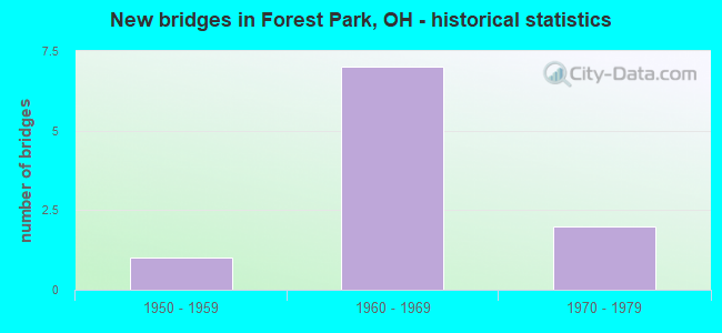
- New bridges - historical statistics
- 11950-1959
- 71960-1969
- 21970-1979


- Bridge Condition - Deck
- 20.0%Very good
- 40.0%Good
- 40.0%Satisfactory

- Bridge Condition - Superstructure
- 60.0%Good
- 20.0%Satisfactory
- 20.0%Poor

- Bridge Condition - Substructure
- 20.0%Very good
- 40.0%Good
- 40.0%Satisfactory
Find on map >> Show street view
Structure Number: 310471, Location: OVER I 275 (Lat: 39.295089, Lng: -84.541181), Route carried "on" structure: County highway C0266, Year Built: 1968, Status: Open, Structure Length: 9.48m (31.10ft), Average Daily Traffic: 26,604 (year 2015), Truck Traffic: 5%, Average Future Daily Traffic: 115,955 (year 2035), Design Load: HS 20, Features Intersected: I-275, Facility Carried by Structure: KEMPER ROAD
Minimum Vertical Clearance: 30+ m (98+ ft), Kilometerpoint: 84.973, Lanes on structure: 2, Lanes under structure: 6, Owner: State Highway Agency, Approaching Roadway Width: 7.3m (24.0ft), Skew: 2 degrees, Material/Design: Steel continuous, Design/Construction: Stringer/Multi-beam, Number Of Spans In Main Unit: 4, Length of Maximum Span: 28.0m (91.9ft), Curb or Sidewalk Widths: Left: 1.2m (3.9ft), Right: 1.2m (3.9ft), Curb-To-Curb Width: 9.1m (29.9ft), Out-to-Out Width: 12.3m (40.4ft)
Condition: Deck: Good, Superstructure: Good, Substructure: Good, Operating Rating: 42.1 metric tons, Method Used To Determine Operating Rating: Load Factor (LF) rating reported by rating factor (RF) method using MS18 loading, Inventory Rating: 32.4 metric tons, Method Used To Determine Inventory Rating: Load Factor (LF) rating reported by rating factor (RF) method using MS18 loading, Structural Evaluation: Better than present minimum criteria, Deck Geometry: Meets minimum limits, Underclear: Meets minimum limits, Approach Roadway Alignment: Equal to present desirable criteria, Designated Inspection Frequency: Every 24 months, Inspection Date: March 2021, Deck Structure Type: Concrete Cast-file-Place, Wearing Surface/Protective System: Wearing Surface: Latex Concrete
Find on map >> Show street view
Structure Number: 3111474, Location: OVER IR 275 (Lat: 39.284519, Lng: -84.564161), Route carried "on" structure: US 127, Year Built: 1971, Status: Open, Structure Length: 12.16m (39.90ft), Average Daily Traffic: 22,503 (year 2018), Truck Traffic: 5%, Average Future Daily Traffic: 31,234 (year 2038), Design Load: H 20, Features Intersected: I275
Minimum Vertical Clearance: 30+ m (98+ ft), Kilometerpoint: 23.561, Lanes on structure: 4, Lanes under structure: 7, Base Highway Network: Yes, Owner: State Highway Agency, Approaching Roadway Width: 25.6m (84.0ft), Skew: 4 degrees, Material/Design: Steel continuous, Design/Construction: Stringer/Multi-beam, Number Of Spans In Main Unit: 3, Number Of Approach Spans: 1, Length of Maximum Span: 41.5m (136.2ft), Curb-To-Curb Width: 25.6m (84.0ft), Out-to-Out Width: 27.4m (89.9ft)
Condition: Deck: Satisfactory, Superstructure: Satisfactory, Substructure: Satisfactory, Operating Rating: 42.1 metric tons, Method Used To Determine Operating Rating: Allowable Stress (AS) rating reported by rating factor (RF) method using MS18 loading, Inventory Rating: 32.4 metric tons, Method Used To Determine Inventory Rating: Allowable Stress (AS) rating reported by rating factor (RF) method using MS18 loading, Structural Evaluation: Equal to present minimum criteria, Deck Geometry: Superior to present desirable criteria, Underclear: Somewhat better than minimum adequacy, Approach Roadway Alignment: Superior to present desirable criteria, Designated Inspection Frequency: Every 12 months, Inspection Date: April 2021, Deck Structure Type: Concrete Cast-file-Place, Wearing Surface/Protective System: Wearing Surface: Integral Concrete
Find on map >> Show street view
Structure Number: 3111768, Location: .1 MI W OF SR 126 (Lat: 39.294589, Lng: -84.543239), Route carried "on" structure: County highway C0229, Year Built: 1968, Status: Open, Structure Length: 9.18m (30.12ft), Average Daily Traffic: 14,148 (year 2015), Truck Traffic: 5%, Average Future Daily Traffic: 115,955 (year 2035), Design Load: H 20, Features Intersected: I275, Facility Carried by Structure: MILL RD
Minimum Vertical Clearance: 30+ m (98+ ft), Kilometerpoint: 22.370, Lanes on structure: 2, Lanes under structure: 6, Owner: State Highway Agency, Approaching Roadway Width: 12.2m (40.0ft), Skew: 2 degrees, Material/Design: Steel continuous, Design/Construction: Stringer/Multi-beam, Number Of Spans In Main Unit: 4, Length of Maximum Span: 26.6m (87.3ft), Curb or Sidewalk Widths: Left: 1.2m (3.9ft), Right: 1.2m (3.9ft), Curb-To-Curb Width: 9.1m (29.9ft), Out-to-Out Width: 12.3m (40.4ft)
Condition: Deck: Good, Superstructure: Good, Substructure: Good, Operating Rating: 42.1 metric tons, Method Used To Determine Operating Rating: Load Factor (LF) rating reported by rating factor (RF) method using MS18 loading, Inventory Rating: 32.4 metric tons, Method Used To Determine Inventory Rating: Load Factor (LF) rating reported by rating factor (RF) method using MS18 loading, Structural Evaluation: Better than present minimum criteria, Deck Geometry: Meets minimum limits, Underclear: Meets minimum limits, Approach Roadway Alignment: Superior to present desirable criteria, Designated Inspection Frequency: Every 24 months, Inspection Date: March 2021, Deck Structure Type: Concrete Cast-file-Place, Wearing Surface/Protective System: Wearing Surface: Latex Concrete
Find on map >> Show street view
Structure Number: 3111792, Location: .9 MI E OF SR 126 (Lat: 39.299211, Lng: -84.523981), Route carried "on" structure: County highway C0239, Year Built: 1968, Year Reconstructed: 2012, Status: Open, Structure Length: 9.44m (30.97ft), Average Daily Traffic: 60,703 (year 2015), Truck Traffic: 2%, Average Future Daily Traffic: 91,986 (year 2035), Design Load: HS 20+Mod, Features Intersected: I275, Facility Carried by Structure: WINTON RD
Minimum Vertical Clearance: 30+ m (98+ ft), Kilometerpoint: 27.520, Lanes on structure: 7, Lanes under structure: 7, Owner: State Highway Agency, Approaching Roadway Width: 30.5m (100.1ft), Skew: 1 degrees, Material/Design: Steel continuous, Design/Construction: Stringer/Multi-beam, Number Of Spans In Main Unit: 4, Length of Maximum Span: 26.4m (86.6ft), Curb or Sidewalk Widths: Left: 0.0m, Right: 2.6m (8.5ft), Curb-To-Curb Width: 30.1m (98.8ft), Out-to-Out Width: 30.8m (101.0ft)
Condition: Deck: Very good, Superstructure: Good, Substructure: Very good, Operating Rating: 48.6 metric tons, Method Used To Determine Operating Rating: Load Factor (LF) rating reported by rating factor (RF) method using MS18 loading, Inventory Rating: 29.2 metric tons, Method Used To Determine Inventory Rating: Load Factor (LF) rating reported by rating factor (RF) method using MS18 loading, Structural Evaluation: Better than present minimum criteria, Deck Geometry: Equal to present minimum criteria, Underclear: Meets minimum limits, Approach Roadway Alignment: Superior to present desirable criteria, Designated Inspection Frequency: Every 24 months, Inspection Date: March 2021, Deck Structure Type: Concrete Cast-file-Place, Wearing Surface/Protective System: Wearing Surface: Monolithic Concrete, Deck Protection: Epoxy Coated Reinforcing
Find on map >> Show street view
Structure Number: 3137376, Location: 1.78MI E OF MILL RD (Lat: 39.275411, Lng: -84.512161), Route carried "on" structure: County highway C0235, Year Built: 1957, Status: Open, Structure Length: 0.73m (2.40ft), Average Daily Traffic: 23,441 (year 2015), Truck Traffic: 1%, Average Future Daily Traffic: 32,536 (year 2035), Design Load: HS 20+Mod, Features Intersected: TRIB WEST FORK MILL CREE, Facility Carried by Structure: WEST SHARON ROAD
Minimum Vertical Clearance: 30+ m (98+ ft), Kilometerpoint: 2.865, Lanes on structure: 2, Owner: County Highway Agency, Approaching Roadway Width: 9.8m (32.2ft), Material/Design: Steel, Design/Construction: Culvert, Number Of Spans In Main Unit: 2, Length of Maximum Span: 2.7m (8.9ft)
Condition: Channel: Good, Culverts: Good, Operating Rating: 44.7 metric tons, Method Used To Determine Operating Rating: Load Factor (LF) rating reported by rating factor (RF) method using MS18 loading, Inventory Rating: 34.7 metric tons, Method Used To Determine Inventory Rating: Load Factor (LF) rating reported by rating factor (RF) method using MS18 loading, Structural Evaluation: Better than present minimum criteria, Waterway Adequacy: Equal to present minimum criteria, Approach Roadway Alignment: Better than present minimum criteria, Designated Inspection Frequency: Every 24 months, Inspection Date: April 2021
Find on map >> Show street view
Structure Number: 3137384, Location: 8.44 MI N OF SPRING GROVE (Lat: 39.278319, Lng: -84.521900), Route carried "on" structure: City street S0469, Year Built: 1969, Status: Open, Structure Length: 2.96m (9.71ft), Average Daily Traffic: 40,186 (year 2015), Truck Traffic: 2%, Average Future Daily Traffic: 55,778 (year 2035), Design Load: HL 93, Features Intersected: WINTON WOODS PARK DRIVE, Facility Carried by Structure: HALL WINTON ROAD
Minimum Vertical Clearance: 30+ m (98+ ft), Kilometerpoint: 13.583, Lanes on structure: 4, Owner: County Highway Agency, Approaching Roadway Width: 27.4m (89.9ft), Skew: 10 degrees, Material/Design: Prestressed concrete, Design/Construction: Box Beam or Girders - Multiple, Number Of Spans In Main Unit: 3, Length of Maximum Span: 9.8m (32.2ft), Curb or Sidewalk Widths: Left: 0.8m (2.6ft), Right: 0.8m (2.6ft), Curb-To-Curb Width: 24.7m (81.0ft), Out-to-Out Width: 26.8m (87.9ft)
Condition: Deck: Satisfactory, Superstructure: Poor, Substructure: Satisfactory, Operating Rating: 39.9 metric tons, Method Used To Determine Operating Rating: Load and Resistance Factor Rating (LRFR) rating reported by rating factor(RF) method using HL-93 loadings, Inventory Rating: 30.8 metric tons, Method Used To Determine Inventory Rating: Load and Resistance Factor Rating (LRFR) rating reported by rating factor(RF) method using HL-93 loadings, Structural Evaluation: Meets minimum limits, Deck Geometry: Superior to present desirable criteria, Approach Roadway Alignment: Better than present minimum criteria, Designated Inspection Frequency: Every 12 months, Inspection Date: April 2021, Deck Structure Type: Concrete Cast-file-Place, Wearing Surface/Protective System: Wearing Surface: Monolithic Concrete
Find on map >> Show street view
Structure Number: 310471, Location: OVER I 275 (Lat: 39.295089, Lng: -84.541181), Route carried "under" structure: Interstate 275, Year Built: 1968, Structure Length: 0. m, Average Daily Traffic: 83,541 (year 2015), Truck Traffic: 10%, Features Intersected: KEMPER ROAD, Facility Carried by Structure: KEMPER ROAD
Minimum Vertical Clearance: 5.01m (16.44ft), Kilometerpoint: 32.621, Lanes on structure: 2, Lanes under structure: 6, Material/Design: Steel continuous, Design/Construction: Stringer/Multi-beam, Length of Maximum Span: 28.0m (91.9ft)
Find on map >> Show street view
Structure Number: 3111474, Location: OVER IR 275 (Lat: 39.284519, Lng: -84.564161), Route carried "under" structure: Interstate 275, Year Built: 1971, Structure Length: 0. m, Average Daily Traffic: 61,644 (year 2015), Truck Traffic: 12%, Features Intersected: US127, Facility Carried by Structure: US 127
Minimum Vertical Clearance: 4.88m (16.01ft), Kilometerpoint: 30.288, Lanes on structure: 4, Lanes under structure: 7, Material/Design: Steel continuous, Design/Construction: Stringer/Multi-beam, Length of Maximum Span: 41.5m (136.2ft)
Find on map >> Show street view
Structure Number: 3111768, Location: .1 MI W OF SR 126 (Lat: 39.294589, Lng: -84.543239), Route carried "under" structure: Interstate 275, Year Built: 1968, Structure Length: 0. m, Average Daily Traffic: 83,541 (year 2015), Truck Traffic: 10%, Features Intersected: MILL ROAD, Facility Carried by Structure: MILL RD
Minimum Vertical Clearance: 5.26m (17.26ft), Kilometerpoint: 32.444, Lanes on structure: 2, Lanes under structure: 6, Material/Design: Steel continuous, Design/Construction: Stringer/Multi-beam, Length of Maximum Span: 26.6m (87.3ft)
Find on map >> Show street view
Structure Number: 3111792, Location: .9 MI E OF SR 126 (Lat: 39.299211, Lng: -84.523981), Route carried "under" structure: Interstate 275, Year Built: 1968, Structure Length: 0. m, Average Daily Traffic: 66,272 (year 2015), Truck Traffic: 9%, Features Intersected: WINTON ROAD
Minimum Vertical Clearance: 4.98m (16.34ft), Kilometerpoint: 34.166, Lanes on structure: 7, Lanes under structure: 7, Material/Design: Steel continuous, Design/Construction: Stringer/Multi-beam, Length of Maximum Span: 26.4m (86.6ft)