Bridge Statistics for El Cerrito, California (CA)
Condition, Traffic, Stress, Structural Evaluation, Project Costs
- National Bridge Inventory (NBI) Statistics
- 21Number of bridges
- 95ft / 28.6mTotal length
- 869,600Total average daily traffic
- 83,443Total average daily truck traffic
- National Bridge Inventory (NBI) Registered Bridges for El Cerrito
- No street view available for this location
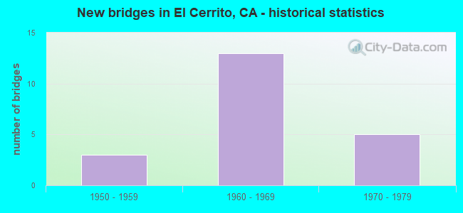
- New bridges - historical statistics
- 31950-1959
- 131960-1969
- 51970-1979

- Reconstructed bridges - Historical Statistics
- 21980-1989
- 11990-1999


Find on map >> Show street view
Structure Number: 28 0030L, Location: 04-CC-160-0.50 (Lat: 38.012075, Lng: -121.752239), Route carried "on" structure: State highway 160, Year Built: 1971, Status: Open, Structure Length: 4.82m (15.81ft), Average Daily Traffic: 6,800 (year 2018), Truck Traffic: 7%, Average Future Daily Traffic: 8,793 (year 2042), Design Load: HS 20, Features Intersected: WILBUR AVENUE
Minimum Vertical Clearance: 30+ m (98+ ft), Kilometerpoint: 0.500, Lanes on structure: 2, Lanes under structure: 5, Base Highway Network: Yes (Inventory Route: 1, Subroute: 1), Owner: State Highway Agency, Approaching Roadway Width: 11.9m (39.0ft), Skew: 1 degrees, Material/Design: Prestressed concrete, Design/Construction: Box Beam or Girders - Multiple, Number Of Spans In Main Unit: 1, Length of Maximum Span: 47.5m (155.8ft), Curb-To-Curb Width: 11.9m (39.0ft), Out-to-Out Width: 12.5m (41.0ft)
Condition: Deck: Good, Superstructure: Good, Substructure: Good, Operating Rating: 55.7 metric tons, Method Used To Determine Operating Rating: Load and Resistance Factor Rating (LRFR) rating reported by rating factor(RF) method using HL-93 loadings, Inventory Rating: 35.0 metric tons, Method Used To Determine Inventory Rating: Load and Resistance Factor Rating (LRFR) rating reported by rating factor(RF) method using HL-93 loadings, Structural Evaluation: Better than present minimum criteria, Deck Geometry: Equal to present minimum criteria, Underclear: Somewhat better than minimum adequacy, Approach Roadway Alignment: Equal to present desirable criteria, Designated Inspection Frequency: Every 24 months, Inspection Date: July 2020, Deck Structure Type: Concrete Cast-file-Place
Find on map >> Show street view
Structure Number: 28 0034, Location: 04-CC-080-1.67-ECR (Lat: 37.920642, Lng: -122.317494), Route carried "on" structure: Interstate 80, Year Built: 1956, Year Reconstructed: 1997, Status: Open, Structure Length: 8.90m (29.20ft), Average Daily Traffic: 179,000 (year 2009), Truck Traffic: 3%, Average Future Daily Traffic: 231,540 (year 2041), Design Load: HS 20, Features Intersected: POTRERO AVE & S80 ON RMP
Minimum Vertical Clearance: 30+ m (98+ ft), Kilometerpoint: 1.670, Lanes on structure: 8, Lanes under structure: 4, Base Highway Network: Yes (, Subroute: 1), Owner: State Highway Agency, Approaching Roadway Width: 36.9m (121.1ft), Skew: 39 degrees, Material/Design: Concrete continuous, Design/Construction: Box Beam or Girders - Multiple, Number Of Spans In Main Unit: 4, Length of Maximum Span: 34.7m (113.8ft), Curb-To-Curb Width: 36.9m (121.1ft), Out-to-Out Width: 40.6m (133.2ft)
Condition: Deck: Good, Superstructure: Good, Substructure: Good, Operating Rating: 54.1 metric tons, Method Used To Determine Operating Rating: Field evaluation and documented engineering judgment, Inventory Rating: 32.4 metric tons, Method Used To Determine Inventory Rating: Field evaluation and documented engineering judgment, Structural Evaluation: Better than present minimum criteria, Deck Geometry: Equal to present desirable criteria, Underclear: High priority of corrective action, Approach Roadway Alignment: Equal to present desirable criteria, Designated Inspection Frequency: Every 24 months, Inspection Date: June 2021, Deck Structure Type: Concrete Cast-file-Place, Wearing Surface/Protective System: Wearing Surface: Bituminous
Find on map >> Show street view
Structure Number: 56 0558L, Location: 08-RIV-015-37.82 (Lat: 33.831811, Lng: -117.529744), Route carried "on" structure: Interstate 15, Year Built: 1966, Year Reconstructed: 1987, Status: Open, Structure Length: 4.24m (13.91ft), Average Daily Traffic: 182,000 (year 2012), Truck Traffic: 10%, Average Future Daily Traffic: 222,396 (year 2042), Design Load: HS 20, Features Intersected: EL CERRITO ROAD
Minimum Vertical Clearance: 30+ m (98+ ft), Kilometerpoint: 37.820, Lanes on structure: 3, Lanes under structure: 5, Base Highway Network: Yes (, Subroute: 1), Owner: State Highway Agency, Approaching Roadway Width: 15.3m (50.2ft), Material/Design: Concrete continuous, Design/Construction: Box Beam or Girders - Multiple, Number Of Spans In Main Unit: 3, Length of Maximum Span: 24.1m (79.1ft), Curb-To-Curb Width: 15.3m (50.2ft), Out-to-Out Width: 16.2m (53.1ft)
Condition: Deck: Good, Superstructure: Good, Substructure: Good, Operating Rating: 39.9 metric tons, Method Used To Determine Operating Rating: Load and Resistance Factor Rating (LRFR) rating reported by rating factor(RF) method using HL-93 loadings, Inventory Rating: 30.8 metric tons, Method Used To Determine Inventory Rating: Load and Resistance Factor Rating (LRFR) rating reported by rating factor(RF) method using HL-93 loadings, Structural Evaluation: Better than present minimum criteria, Deck Geometry: Meets minimum limits, Underclear: Equal to present minimum criteria, Approach Roadway Alignment: Superior to present desirable criteria, Designated Inspection Frequency: Every 24 months, Inspection Date: Febuary 2020, Deck Structure Type: Concrete Cast-file-Place
Find on map >> Show street view
Structure Number: 56 0558R, Location: 08-RIV-015-37.82 (Lat: 33.831967, Lng: -117.529428), Route carried "on" structure: Interstate 15, Year Built: 1966, Year Reconstructed: 1987, Status: Open, Structure Length: 4.24m (13.91ft), Average Daily Traffic: 182,000 (year 2012), Truck Traffic: 10%, Average Future Daily Traffic: 222,396 (year 2042), Design Load: HS 20, Features Intersected: EL CERRITO ROAD
Minimum Vertical Clearance: 30+ m (98+ ft), Kilometerpoint: 37.820, Lanes on structure: 3, Lanes under structure: 5, Base Highway Network: Yes (, Subroute: 1), Owner: State Highway Agency, Approaching Roadway Width: 15.3m (50.2ft), Material/Design: Concrete continuous, Design/Construction: Box Beam or Girders - Multiple, Number Of Spans In Main Unit: 3, Length of Maximum Span: 24.1m (79.1ft), Curb-To-Curb Width: 15.3m (50.2ft), Out-to-Out Width: 16.2m (53.1ft)
Condition: Deck: Good, Superstructure: Good, Substructure: Good, Operating Rating: 44.7 metric tons, Method Used To Determine Operating Rating: Load and Resistance Factor Rating (LRFR) rating reported by rating factor(RF) method using HL-93 loadings, Inventory Rating: 32.4 metric tons, Method Used To Determine Inventory Rating: Load and Resistance Factor Rating (LRFR) rating reported by rating factor(RF) method using HL-93 loadings, Structural Evaluation: Better than present minimum criteria, Deck Geometry: Meets minimum limits, Underclear: Equal to present minimum criteria, Approach Roadway Alignment: Superior to present desirable criteria, Designated Inspection Frequency: Every 24 months, Inspection Date: Febuary 2020, Deck Structure Type: Concrete Cast-file-Place
Find on map >> Show street view
Structure Number: 56 0644L, Location: 08-RIV-015-39.40 (Lat: 33.853711, Lng: -117.535422), Route carried "on" structure: Interstate 15, Year Built: 1975, Status: Open, Structure Length: 3.27m (10.73ft), Average Daily Traffic: 110,000 (year 2012), Truck Traffic: 17%, Average Future Daily Traffic: 115,585 (year 2042), Design Load: HS 20, Features Intersected: OLD TEMESCAL ROAD
Minimum Vertical Clearance: 30+ m (98+ ft), Kilometerpoint: 39.400, Lanes on structure: 4, Lanes under structure: 2, Base Highway Network: Yes (, Subroute: 1), Owner: State Highway Agency, Approaching Roadway Width: 27.6m (90.6ft), Material/Design: Prestressed concrete, Design/Construction: Box Beam or Girders - Multiple, Number Of Spans In Main Unit: 1, Length of Maximum Span: 32.7m (107.3ft), Curb-To-Curb Width: 27.6m (90.6ft), Out-to-Out Width: 28.7m (94.2ft)
Condition: Deck: Good, Superstructure: Good, Substructure: Good, Operating Rating: 59.6 metric tons, Method Used To Determine Operating Rating: Load and Resistance Factor Rating (LRFR) rating reported by rating factor(RF) method using HL-93 loadings, Inventory Rating: 45.7 metric tons, Method Used To Determine Inventory Rating: Load and Resistance Factor Rating (LRFR) rating reported by rating factor(RF) method using HL-93 loadings, Structural Evaluation: Better than present minimum criteria, Deck Geometry: Superior to present desirable criteria, Underclear: Meets minimum limits, Approach Roadway Alignment: Equal to present desirable criteria, Designated Inspection Frequency: Every 24 months, Inspection Date: Febuary 2020, Deck Structure Type: Concrete Cast-file-Place
Find on map >> Show street view
Structure Number: 56 0644R, Location: 08-RIV-015-39.40 (Lat: 33.853800, Lng: -117.535044), Route carried "on" structure: Interstate 15, Year Built: 1975, Status: Open, Structure Length: 3.17m (10.40ft), Average Daily Traffic: 110,000 (year 2012), Truck Traffic: 17%, Average Future Daily Traffic: 115,585 (year 2042), Design Load: HS 20, Features Intersected: OLD TEMESCAL ROAD
Minimum Vertical Clearance: 30+ m (98+ ft), Kilometerpoint: 39.400, Lanes on structure: 4, Lanes under structure: 2, Base Highway Network: Yes (, Subroute: 1), Owner: State Highway Agency, Approaching Roadway Width: 19.7m (64.6ft), Material/Design: Prestressed concrete, Design/Construction: Box Beam or Girders - Multiple, Number Of Spans In Main Unit: 1, Length of Maximum Span: 31.7m (104.0ft), Curb-To-Curb Width: 19.7m (64.6ft), Out-to-Out Width: 20.7m (67.9ft)
Condition: Deck: Good, Superstructure: Good, Substructure: Good, Operating Rating: 65.1 metric tons, Method Used To Determine Operating Rating: Load and Resistance Factor Rating (LRFR) rating reported by rating factor(RF) method using HL-93 loadings, Inventory Rating: 50.2 metric tons, Method Used To Determine Inventory Rating: Load and Resistance Factor Rating (LRFR) rating reported by rating factor(RF) method using HL-93 loadings, Structural Evaluation: Better than present minimum criteria, Deck Geometry: Equal to present minimum criteria, Underclear: Meets minimum limits, Approach Roadway Alignment: Equal to present desirable criteria, Designated Inspection Frequency: Every 24 months, Inspection Date: Febuary 2020, Deck Structure Type: Concrete Cast-file-Place
Find on map >> Show street view
Structure Number: 28 0034, Location: 04-CC-080-1.67-ECR (Lat: 37.920642, Lng: -122.317494), Route carried "under" structure: City street , Year Built: 1956, Structure Length: 0. m, Average Daily Traffic: 6,300 (year 2009), Truck Traffic: 7%, Features Intersected: POTRERO AVE & S80 ON RMP, Facility Carried by Structure: INTERSTATE 80
Minimum Vertical Clearance: 4.47m (14.67ft), Kilometerpoint: 0.000, Lanes on structure: 8, Lanes under structure: 3, Material/Design: Concrete continuous, Design/Construction: Box Beam or Girders - Multiple, Length of Maximum Span: 34.7m (113.8ft)
Find on map >> Show street view
Structure Number: 28 0034, Location: 04-CC-080-1.67-ECR (Lat: 37.920642, Lng: -122.317494), Route carried "under" structure: Ramp Interstate 80, Year Built: 1956, Structure Length: 0. m, Average Daily Traffic: 7,400 (year 2009), Truck Traffic: 7%, Features Intersected: POTRERO AVE & S80 ON RMP
Minimum Vertical Clearance: 4.47m (14.67ft), Kilometerpoint: 1.670, Lanes on structure: 8, Lanes under structure: 1, Material/Design: Concrete continuous, Design/Construction: Box Beam or Girders - Multiple, Length of Maximum Span: 34.7m (113.8ft)
Find on map >> Show street view
Structure Number: 28C014, Location: 0.2 MI S/O MACDONALD AVE (Lat: 37.930422, Lng: -122.322183), Route carried "under" structure: City street , Year Built: 1969, Structure Length: 0. m, Average Daily Traffic: 26,780 (year 2020), Truck Traffic: 6%, Features Intersected: SAN PABLO AVE, Facility Carried by Structure: BARTD
Minimum Vertical Clearance: 4.46m (14.63ft), Kilometerpoint: 0.000, Lanes under structure: 4, Material/Design: Prestressed concrete, Design/Construction: Box Beam or Girders - Multiple, Length of Maximum Span: 12.1m (39.7ft)
Find on map >> Show street view
Structure Number: 28C0304, Location: OVER FAIRMOUNT AVE (Lat: 37.901822, Lng: -122.298225), Route carried "under" structure: City street , Year Built: 1965, Structure Length: 0. m, Average Daily Traffic: 10,510 (year 2020), Truck Traffic: 2%, Features Intersected: FAIRMOUNT AVE, Facility Carried by Structure: BARTD
Minimum Vertical Clearance: 4.85m (15.91ft), Kilometerpoint: 0.000, Lanes under structure: 2, Material/Design: Prestressed concrete, Design/Construction: Tee Beam, Length of Maximum Span: 18.3m (60.0ft)
Find on map >> Show street view
Structure Number: 28C0305, Location: OVER CENTRAL AVE (Lat: 37.903008, Lng: -122.299156), Route carried "under" structure: City street , Year Built: 1965, Structure Length: 0. m, Average Daily Traffic: 6,630 (year 2020), Truck Traffic: 2%, Features Intersected: CENTRAL AVE, Facility Carried by Structure: BARTD
Minimum Vertical Clearance: 5.74m (18.83ft), Kilometerpoint: 0.000, Lanes under structure: 2, Material/Design: Prestressed concrete, Design/Construction: Tee Beam, Length of Maximum Span: 24.7m (81.0ft)
Find on map >> Show street view
Structure Number: 28C0306, Location: OVER STOCKTON AVE (Lat: 37.908622, Lng: -122.303761), Route carried "under" structure: City street , Year Built: 1965, Structure Length: 0. m, Average Daily Traffic: 5,500 (year 2020), Truck Traffic: 2%, Features Intersected: STOCKTON AVE, Facility Carried by Structure: BARTD (R3003)
Minimum Vertical Clearance: 4.98m (16.34ft), Kilometerpoint: 0.000, Lanes under structure: 2, Material/Design: Prestressed concrete, Design/Construction: Tee Beam, Length of Maximum Span: 25.0m (82.0ft)
Find on map >> Show street view
Structure Number: 28C0307, Location: OVER MOESER LANE (Lat: 37.912047, Lng: -122.306550), Route carried "under" structure: City street , Year Built: 1965, Structure Length: 0. m, Average Daily Traffic: 7,260 (year 2020), Truck Traffic: 2%, Features Intersected: MOESER LANE, Facility Carried by Structure: BARTD (R3003)
Minimum Vertical Clearance: 4.89m (16.04ft), Kilometerpoint: 0.000, Lanes under structure: 2, Material/Design: Prestressed concrete, Design/Construction: Box Beam or Girders - Multiple, Length of Maximum Span: 25.0m (82.0ft)
Find on map >> Show street view
Structure Number: 28C0308, Location: OVER MANILA AVE (Lat: 37.916314, Lng: -122.309947), Route carried "under" structure: City street , Year Built: 1965, Structure Length: 0. m, Average Daily Traffic: 2,960 (year 2020), Truck Traffic: 2%, Features Intersected: MANILA AVE, Facility Carried by Structure: BARTD (R3003)
Minimum Vertical Clearance: 4.96m (16.27ft), Kilometerpoint: 0.000, Lanes under structure: 2, Material/Design: Prestressed concrete, Design/Construction: Box Beam or Girders - Multiple, Length of Maximum Span: 25.9m (85.0ft)
Find on map >> Show street view
Structure Number: 28C0309, Location: UNDER BARTD TRACKS (Lat: 37.920967, Lng: -122.313592), Route carried "under" structure: City street , Year Built: 1965, Structure Length: 0. m, Average Daily Traffic: 8,080 (year 2020), Truck Traffic: 2%, Features Intersected: POTRERO AVE, Facility Carried by Structure: BARTD (R3003)
Minimum Vertical Clearance: 5.49m (18.01ft), Kilometerpoint: 0.000, Lanes under structure: 2, Material/Design: Prestressed concrete, Design/Construction: Box Beam or Girders - Multiple, Length of Maximum Span: 25.0m (82.0ft)
Find on map >> Show street view
Structure Number: 28C031, Location: OVER HILL ST (Lat: 37.924044, Lng: -122.316008), Route carried "under" structure: City street , Year Built: 1965, Structure Length: 0. m, Average Daily Traffic: 2,880 (year 2020), Truck Traffic: 2%, Features Intersected: HILL ST, Facility Carried by Structure: BARTD (R3003)
Minimum Vertical Clearance: 5.82m (19.09ft), Kilometerpoint: 0.000, Lanes under structure: 4, Material/Design: Prestressed concrete, Design/Construction: Box Beam or Girders - Multiple, Length of Maximum Span: 24.7m (81.0ft)
Find on map >> Show street view
Structure Number: 28C0311, Location: OVER CUTTING BLVD (Lat: 37.925783, Lng: -122.317219), Route carried "under" structure: City street , Year Built: 1965, Structure Length: 0. m, Average Daily Traffic: 5,900 (year 2020), Truck Traffic: 2%, Features Intersected: CUTTING BLVD, Facility Carried by Structure: BARTD
Minimum Vertical Clearance: 5.47m (17.95ft), Kilometerpoint: 0.000, Lanes under structure: 3, Material/Design: Prestressed concrete, Design/Construction: Box Beam or Girders - Multiple, Length of Maximum Span: 25.3m (83.0ft)
Find on map >> Show street view
Structure Number: 56 0558L, Location: 08-RIV-015-37.82 (Lat: 33.831811, Lng: -117.529744), Route carried "under" structure: County highway R105, Year Built: 1966, Structure Length: 0. m, Average Daily Traffic: 4,000 (year 2012), Truck Traffic: 1%, Features Intersected: EL CERRITO ROAD, Facility Carried by Structure: INTERSTATE 15 SB
Minimum Vertical Clearance: 4.62m (15.16ft), Kilometerpoint: 0.000, Lanes on structure: 3, Lanes under structure: 5, Material/Design: Concrete continuous, Design/Construction: Box Beam or Girders - Multiple, Length of Maximum Span: 24.1m (79.1ft)
Find on map >> Show street view
Structure Number: 56 0558R, Location: 08-RIV-015-37.82 (Lat: 33.831967, Lng: -117.529428), Route carried "under" structure: County highway R105, Year Built: 1966, Structure Length: 0. m, Average Daily Traffic: 4,000 (year 2012), Truck Traffic: 1%, Features Intersected: EL CERRITO ROAD, Facility Carried by Structure: INTERSTATE 15 NB
Minimum Vertical Clearance: 5.33m (17.49ft), Kilometerpoint: 0.000, Lanes on structure: 3, Lanes under structure: 5, Material/Design: Concrete continuous, Design/Construction: Box Beam or Girders - Multiple, Length of Maximum Span: 24.1m (79.1ft)
Find on map >> Show street view
Structure Number: 56 0644L, Location: 08-RIV-015-39.40 (Lat: 33.853711, Lng: -117.535422), Route carried "under" structure: Other road , Year Built: 1975, Structure Length: 0. m, Average Daily Traffic: 800 (year 2012), Truck Traffic: 10%, Features Intersected: OLD TEMESCAL ROAD, Facility Carried by Structure: INTERSTATE 15 SB
Minimum Vertical Clearance: 6.38m (20.93ft), Kilometerpoint: 0.000, Lanes on structure: 4, Lanes under structure: 2, Material/Design: Prestressed concrete, Design/Construction: Box Beam or Girders - Multiple, Length of Maximum Span: 32.7m (107.3ft)
Find on map >> Show street view
Structure Number: 56 0644R, Location: 08-RIV-015-39.40 (Lat: 33.853800, Lng: -117.535044), Route carried "under" structure: Other road , Year Built: 1975, Structure Length: 0. m, Average Daily Traffic: 800 (year 2012), Truck Traffic: 10%, Features Intersected: OLD TEMESCAL ROAD, Facility Carried by Structure: INTERSTATE 15 NB
Minimum Vertical Clearance: 4.75m (15.58ft), Kilometerpoint: 0.000, Lanes on structure: 4, Lanes under structure: 2, Material/Design: Prestressed concrete, Design/Construction: Box Beam or Girders - Multiple, Length of Maximum Span: 31.7m (104.0ft)