Bridge Statistics for Earlimart, California (CA)
Condition, Traffic, Stress, Structural Evaluation, Project Costs
- National Bridge Inventory (NBI) Statistics
- 12Number of bridges
- 112ft / 33.5mTotal length
- $2,640,000Total costs
- 223,650Total average daily traffic
- 24,367Total average daily truck traffic
- National Bridge Inventory (NBI) Registered Bridges for Earlimart
- No street view available for this location
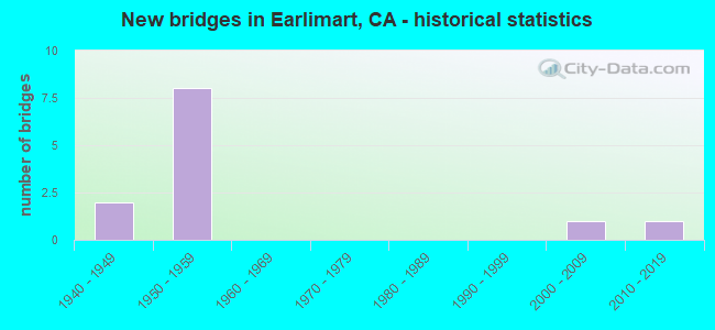
- New bridges - historical statistics
- 21940-1949
- 81950-1959
- 12000-2009
- 12010-2019


- Bridge Condition - Deck
- 55.6%Good
- 11.1%Satisfactory
- 22.2%Fair
- 11.1%Poor

- Bridge Condition - Superstructure
- 55.6%Good
- 11.1%Satisfactory
- 22.2%Fair
- 11.1%Poor

- Bridge Condition - Substructure
- 77.8%Good
- 22.2%Fair

- Bridge Condition - Channel
- 20.0%Excellent
- 40.0%Good
- 40.0%Satisfactory
Find on map >> Show street view
Structure Number: 46 0165, Location: 06-TUL-099-6.15 (Lat: 35.877369, Lng: -119.270917), Route carried "on" structure: ServiceCounty highway , Year Built: 1955, Status: Open, Structure Length: 7.01m (23.00ft), Average Daily Traffic: 3,400 (year 1998), Truck Traffic: 5%, Average Future Daily Traffic: 1,631 (year 2040), Design Load: HS 20, Features Intersected: STATE ROUTE 99, Facility Carried by Structure: AVE 48 (ARMSTRONG)
Minimum Vertical Clearance: 30+ m (98+ ft), Kilometerpoint: 0.000, Lanes on structure: 2, Lanes under structure: 5, Owner: State Highway Agency, Approaching Roadway Width: 10.8m (35.4ft), Skew: 1 degrees, Material/Design: Concrete continuous, Design/Construction: Box Beam or Girders - Multiple, Number Of Spans In Main Unit: 2, Number Of Approach Spans: 2, Length of Maximum Span: 25.0m (82.0ft), Curb or Sidewalk Widths: Left: 1.5m (4.9ft), Right: 0.6m (2.0ft), Curb-To-Curb Width: 8.6m (28.2ft), Out-to-Out Width: 10.8m (35.4ft)
Condition: Deck: Good, Superstructure: Good, Substructure: Good, Operating Rating: 40.5 metric tons, Method Used To Determine Operating Rating: Load and Resistance Factor Rating (LRFR) rating reported by rating factor(RF) method using HL-93 loadings, Inventory Rating: 31.1 metric tons, Method Used To Determine Inventory Rating: Load and Resistance Factor Rating (LRFR) rating reported by rating factor(RF) method using HL-93 loadings, Structural Evaluation: Better than present minimum criteria, Deck Geometry: Meets minimum limits, Underclear: High priority of corrective action, Approach Roadway Alignment: Equal to present desirable criteria, Designated Inspection Frequency: Every 24 months, Inspection Date: August 2020, Deck Structure Type: Concrete Cast-file-Place
Find on map >> Show street view
Structure Number: 46 0166, Location: 06-TUL-099-6.63 (Lat: 35.884150, Lng: -119.272303), Route carried "on" structure: County highway , Year Built: 1955, Status: Open, Structure Length: 6.10m (20.01ft), Average Daily Traffic: 3,800 (year 1998), Truck Traffic: 1%, Average Future Daily Traffic: 15,215 (year 2040), Design Load: HS 20, Features Intersected: STATE ROUTE 99, Facility Carried by Structure: WASHINGTON STREET
Minimum Vertical Clearance: 30+ m (98+ ft), Kilometerpoint: 0.000, Lanes on structure: 2, Lanes under structure: 4, Owner: State Highway Agency, Approaching Roadway Width: 11.5m (37.7ft), Material/Design: Concrete continuous, Design/Construction: Box Beam or Girders - Multiple, Number Of Spans In Main Unit: 2, Number Of Approach Spans: 2, Length of Maximum Span: 17.1m (56.1ft), Curb or Sidewalk Widths: Left: 1.5m (4.9ft), Right: 1.5m (4.9ft), Curb-To-Curb Width: 8.5m (27.9ft), Out-to-Out Width: 11.5m (37.7ft)
Condition: Deck: Good, Superstructure: Good, Substructure: Good, Operating Rating: 42.8 metric tons, Method Used To Determine Operating Rating: Load and Resistance Factor Rating (LRFR) rating reported by rating factor(RF) method using HL-93 loadings, Inventory Rating: 33.0 metric tons, Method Used To Determine Inventory Rating: Load and Resistance Factor Rating (LRFR) rating reported by rating factor(RF) method using HL-93 loadings, Structural Evaluation: Better than present minimum criteria, Deck Geometry: Meets minimum limits, Underclear: High priority of corrective action, Approach Roadway Alignment: Equal to present desirable criteria, Designated Inspection Frequency: Every 48 months, Inspection Date: August 2018, Deck Structure Type: Concrete Cast-file-Place
Find on map >> Show street view
Structure Number: 46 0167, Location: 06-TUL-099-7.17 (Lat: 35.891856, Lng: -119.274350), Route carried "on" structure: County highway W300, Year Built: 1955, Status: Open, Structure Length: 6.52m (21.39ft), Average Daily Traffic: 2,500 (year 1998), Truck Traffic: 3%, Average Future Daily Traffic: 2,698 (year 2042), Design Load: HS 20, Features Intersected: STATE ROUTE 99, Facility Carried by Structure: AVE 56 (CO RD J22)
Minimum Vertical Clearance: 30+ m (98+ ft), Kilometerpoint: 0.000, Lanes on structure: 2, Lanes under structure: 4, Owner: State Highway Agency, Approaching Roadway Width: 9.8m (32.2ft), Skew: 2 degrees, Material/Design: Concrete continuous, Design/Construction: Box Beam or Girders - Multiple, Number Of Spans In Main Unit: 2, Number Of Approach Spans: 2, Length of Maximum Span: 18.6m (61.0ft), Curb or Sidewalk Widths: Left: 0.6m (2.0ft), Right: 1.6m (5.2ft), Curb-To-Curb Width: 8.5m (27.9ft), Out-to-Out Width: 10.5m (34.4ft)
Condition: Deck: Good, Superstructure: Good, Substructure: Good, Operating Rating: 99.8 metric tons, Method Used To Determine Operating Rating: Load Factor (LF), Inventory Rating: 60.6 metric tons, Method Used To Determine Inventory Rating: Load Factor (LF), Structural Evaluation: Better than present minimum criteria, Deck Geometry: Meets minimum limits, Underclear: Meets minimum limits, Approach Roadway Alignment: Equal to present desirable criteria, Designated Inspection Frequency: Every 48 months, Inspection Date: August 2020, Deck Structure Type: Concrete Cast-file-Place
Find on map >> Show street view
Structure Number: 46 0258, Location: 06-TUL-099-4.56 (Lat: 35.854725, Lng: -119.267128), Route carried "on" structure: State highway 99, Year Built: 2001, Status: Open, Structure Length: 2.20m (7.22ft), Average Daily Traffic: 44,500 (year 2009), Average Future Daily Traffic: 69,238 (year 2036), Design Load: HS 20+Mod, Features Intersected: WHITE RIVER SINK
Minimum Vertical Clearance: 30+ m (98+ ft), Kilometerpoint: 4.560, Lanes on structure: 4, Base Highway Network: Yes (, Subroute: 1), Owner: State Highway Agency, Approaching Roadway Width: 39.0m (128.0ft), Material/Design: Concrete continuous, Design/Construction: Slab, Number Of Spans In Main Unit: 3, Length of Maximum Span: 9.0m (29.5ft), Curb-To-Curb Width: 39.0m (128.0ft), Out-to-Out Width: 40.4m (132.5ft)
Condition: Deck: Satisfactory, Superstructure: Satisfactory, Substructure: Good, Channel: Excellent, Operating Rating: 54.1 metric tons, Method Used To Determine Operating Rating: Assigned rating based on Load Factor Design (LFD) reported in metric tons, Inventory Rating: 32.4 metric tons, Method Used To Determine Inventory Rating: Assigned rating based on Load Factor Design (LFD) reported in metric tons, Structural Evaluation: Equal to present minimum criteria, Deck Geometry: Superior to present desirable criteria, Waterway Adequacy: Equal to present desirable criteria, Approach Roadway Alignment: Equal to present desirable criteria, Designated Inspection Frequency: Every 48 months, Inspection Date: August 2018, Deck Structure Type: Concrete Cast-file-Place
Find on map >> Show street view
Structure Number: 46 0268, Location: 06-TUL-099-3.06 (Lat: 35.833683, Lng: -119.260172), Route carried "on" structure: State highway 99, Year Built: 2011, Status: Open, Structure Length: 4.26m (13.98ft), Average Daily Traffic: 44,500 (year 2009), Truck Traffic: 28%, Average Future Daily Traffic: 97,033 (year 2042), Design Load: HL 93, Features Intersected: AVENUE 24
Minimum Vertical Clearance: 30+ m (98+ ft), Kilometerpoint: 3.060, Lanes on structure: 4, Lanes under structure: 2, Base Highway Network: Yes (, Subroute: 1), Owner: State Highway Agency, Approaching Roadway Width: 37.0m (121.4ft), Skew: 31 degrees, Material/Design: Concrete continuous, Design/Construction: Slab, Number Of Spans In Main Unit: 3, Length of Maximum Span: 17.0m (55.8ft), Curb-To-Curb Width: 35.4m (116.1ft), Out-to-Out Width: 36.9m (121.1ft)
Condition: Deck: Poor, Superstructure: Poor, Substructure: Good, Operating Rating: 42.1 metric tons, Method Used To Determine Operating Rating: Assigned ratings based on Load and Resistance Factor Design (LRFD) reported by rating factor (RF) using HL93 loadings, Inventory Rating: 32.4 metric tons, Method Used To Determine Inventory Rating: Assigned ratings based on Load and Resistance Factor Design (LRFD) reported by rating factor (RF) using HL93 loadings, Structural Evaluation: Meets minimum limits, Deck Geometry: Superior to present desirable criteria, Underclear: Better than present minimum criteria, Approach Roadway Alignment: Equal to present desirable criteria, Length Of Structure Improvement: 4.26m (13.98ft), Designated Inspection Frequency: Every 24 months, Inspection Date: August 2020, Bridge Improvement Cost: $1,572,000, Roadway Improvement Cost: $314,000, Total Project Cost: $2,640,000 ( Estimate for 2021), Deck Structure Type: Concrete Cast-file-Place
Find on map >> Show street view
Structure Number: 46C0271, Location: 0.5 MI S OF AVE 40 (Lat: 35.855472, Lng: -119.285878), Route carried "on" structure: County highway , Year Built: 1957, Status: Open, Structure Length: 1.92m (6.30ft), Average Daily Traffic: 325 (year 1978), Truck Traffic: 10%, Average Future Daily Traffic: 544 (year 2040), Features Intersected: WHITE RIVER, Facility Carried by Structure: ROAD 128
Minimum Vertical Clearance: 30+ m (98+ ft), Kilometerpoint: 0.000, Lanes on structure: 2, Owner: County Highway Agency, Approaching Roadway Width: 6.4m (21.0ft), Material/Design: Concrete continuous, Design/Construction: Slab, Number Of Spans In Main Unit: 2, Length of Maximum Span: 9.2m (30.2ft), Curb-To-Curb Width: 8.5m (27.9ft), Out-to-Out Width: 8.5m (27.9ft)
Condition: Deck: Fair, Superstructure: Fair, Substructure: Fair, Channel: Good, Operating Rating: 60.6 metric tons, Method Used To Determine Operating Rating: Load Factor (LF), Inventory Rating: 36.3 metric tons, Method Used To Determine Inventory Rating: Load Factor (LF), Structural Evaluation: Somewhat better than minimum adequacy, Deck Geometry: Equal to present minimum criteria, Waterway Adequacy: Superior to present desirable criteria, Approach Roadway Alignment: Equal to present desirable criteria, Designated Inspection Frequency: Every 24 months, Inspection Date: November 2020, Deck Structure Type: Concrete Cast-file-Place
Find on map >> Show street view
Structure Number: 46C028, Location: 0.5 MI S OF AVE 40 (Lat: 35.855553, Lng: -119.250292), Route carried "on" structure: County highway , Year Built: 1951, Status: Open, Structure Length: 1.83m (6.00ft), Average Daily Traffic: 1,000 (year 1978), Truck Traffic: 5%, Average Future Daily Traffic: 1,350 (year 2040), Features Intersected: WHITE RIVER, Facility Carried by Structure: RD 144
Minimum Vertical Clearance: 30+ m (98+ ft), Kilometerpoint: 0.000, Lanes on structure: 2, Owner: County Highway Agency, Approaching Roadway Width: 7.9m (25.9ft), Material/Design: Concrete continuous, Design/Construction: Slab, Number Of Spans In Main Unit: 5, Length of Maximum Span: 5.3m (17.4ft), Curb or Sidewalk Widths: Left: 0.3m (1.0ft), Right: 0.3m (1.0ft), Curb-To-Curb Width: 7.9m (25.9ft), Out-to-Out Width: 8.5m (27.9ft)
Condition: Deck: Good, Superstructure: Good, Substructure: Fair, Channel: Good, Operating Rating: 53.1 metric tons, Method Used To Determine Operating Rating: Load Factor (LF), Inventory Rating: 32.1 metric tons, Method Used To Determine Inventory Rating: Load Factor (LF), Structural Evaluation: Somewhat better than minimum adequacy, Deck Geometry: Somewhat better than minimum adequacy, Waterway Adequacy: Superior to present desirable criteria, Approach Roadway Alignment: Equal to present desirable criteria, Designated Inspection Frequency: Every 24 months, Inspection Date: November 2020, Deck Structure Type: Concrete Cast-file-Place, Wearing Surface/Protective System: Wearing Surface: Bituminous
Find on map >> Show street view
Structure Number: 46C0283, Location: 2.75 MI S OF AVE 56 (Lat: 35.851969, Lng: -119.232561), Route carried "on" structure: County highway , Year Built: 1948, Status: Open, Structure Length: 1.83m (6.00ft), Average Daily Traffic: 325 (year 1978), Truck Traffic: 10%, Average Future Daily Traffic: 536 (year 2040), Features Intersected: WHITE RIVER, Facility Carried by Structure: RD 152
Minimum Vertical Clearance: 30+ m (98+ ft), Kilometerpoint: 0.000, Lanes on structure: 2, Owner: County Highway Agency, Approaching Roadway Width: 7.9m (25.9ft), Material/Design: Concrete continuous, Design/Construction: Slab, Number Of Spans In Main Unit: 5, Length of Maximum Span: 5.3m (17.4ft), Curb or Sidewalk Widths: Left: 0.3m (1.0ft), Right: 0.3m (1.0ft), Curb-To-Curb Width: 7.9m (25.9ft), Out-to-Out Width: 8.5m (27.9ft)
Condition: Deck: Fair, Superstructure: Fair, Substructure: Good, Channel: Satisfactory, Operating Rating: 36.3 metric tons, Method Used To Determine Operating Rating: Load and Resistance Factor Rating (LRFR) rating reported by rating factor(RF) method using HL-93 loadings, Inventory Rating: 27.9 metric tons, Method Used To Determine Inventory Rating: Load and Resistance Factor Rating (LRFR) rating reported by rating factor(RF) method using HL-93 loadings, Structural Evaluation: Somewhat better than minimum adequacy, Deck Geometry: Somewhat better than minimum adequacy, Waterway Adequacy: Equal to present desirable criteria, Approach Roadway Alignment: Equal to present desirable criteria, Designated Inspection Frequency: Every 24 months, Inspection Date: November 2020, Deck Structure Type: Concrete Cast-file-Place
Find on map >> Show street view
Structure Number: 46C0417, Location: 0.3 MI NORTH OF AVE 32 (Lat: 35.852153, Lng: -119.214708), Route carried "on" structure: County highway , Year Built: 1947, Status: Open, Structure Length: 1.83m (6.00ft), Average Daily Traffic: 300 (year 1982), Truck Traffic: 10%, Average Future Daily Traffic: 536 (year 2040), Features Intersected: WHITE RIVER, Facility Carried by Structure: ROAD 160
Minimum Vertical Clearance: 30+ m (98+ ft), Kilometerpoint: 0.000, Lanes on structure: 2, Owner: County Highway Agency, Approaching Roadway Width: 7.9m (25.9ft), Material/Design: Concrete continuous, Design/Construction: Slab, Number Of Spans In Main Unit: 5, Length of Maximum Span: 5.5m (18.0ft), Curb or Sidewalk Widths: Left: 0.3m (1.0ft), Right: 0.3m (1.0ft), Curb-To-Curb Width: 7.9m (25.9ft), Out-to-Out Width: 8.6m (28.2ft)
Condition: Deck: Good, Superstructure: Good, Substructure: Good, Channel: Satisfactory, Operating Rating: 36.0 metric tons, Method Used To Determine Operating Rating: Load and Resistance Factor Rating (LRFR) rating reported by rating factor(RF) method using HL-93 loadings, Inventory Rating: 27.9 metric tons, Method Used To Determine Inventory Rating: Load and Resistance Factor Rating (LRFR) rating reported by rating factor(RF) method using HL-93 loadings, Structural Evaluation: Better than present minimum criteria, Deck Geometry: Somewhat better than minimum adequacy, Waterway Adequacy: Equal to present desirable criteria, Approach Roadway Alignment: Equal to present desirable criteria, Designated Inspection Frequency: Every 24 months, Inspection Date: November 2020, Deck Structure Type: Concrete Cast-file-Place, Wearing Surface/Protective System: Wearing Surface: Bituminous
Find on map >> Show street view
Structure Number: 46 0165, Location: 06-TUL-099-6.15 (Lat: 35.877369, Lng: -119.270917), Route carried "under" structure: State highway 99, Year Built: 1955, Structure Length: 0. m, Average Daily Traffic: 41,000 (year 2009), Features Intersected: STATE ROUTE 99, Facility Carried by Structure: AVE 48 (ARMSTRONG)
Minimum Vertical Clearance: 4.57m (14.99ft), Kilometerpoint: 6.150, Lanes on structure: 2, Lanes under structure: 5, Material/Design: Concrete continuous, Design/Construction: Box Beam or Girders - Multiple, Length of Maximum Span: 25.0m (82.0ft)
Find on map >> Show street view
Structure Number: 46 0166, Location: 06-TUL-099-6.63 (Lat: 35.884150, Lng: -119.272303), Route carried "under" structure: State highway 99, Year Built: 1955, Structure Length: 0. m, Average Daily Traffic: 41,000 (year 2009), Features Intersected: STATE ROUTE 99, Facility Carried by Structure: WASHINGTON STREET
Minimum Vertical Clearance: 4.64m (15.22ft), Kilometerpoint: 6.630, Lanes on structure: 2, Lanes under structure: 4, Material/Design: Concrete continuous, Design/Construction: Box Beam or Girders - Multiple, Length of Maximum Span: 17.1m (56.1ft)
Find on map >> Show street view
Structure Number: 46 0167, Location: 06-TUL-099-7.17 (Lat: 35.891856, Lng: -119.274350), Route carried "under" structure: State highway 99, Year Built: 1955, Structure Length: 0. m, Average Daily Traffic: 41,000 (year 2009), Truck Traffic: 28%, Features Intersected: STATE ROUTE 99, Facility Carried by Structure: AVE 56 (CO RD J22)
Minimum Vertical Clearance: 4.59m (15.06ft), Kilometerpoint: 7.170, Lanes on structure: 2, Lanes under structure: 4, Material/Design: Concrete continuous, Design/Construction: Box Beam or Girders - Multiple, Length of Maximum Span: 18.6m (61.0ft)