Bridge Statistics for Dunn Loring, Virginia (VA)
Condition, Traffic, Stress, Structural Evaluation, Project Costs
- National Bridge Inventory (NBI) Statistics
- 24Number of bridges
- 226ft / 68.8mTotal length
- $187,000Total costs
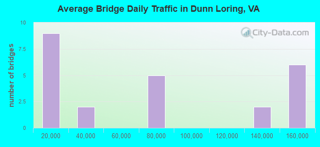
- 1,609,125Total average daily traffic
- 103,215Total average daily truck traffic
- National Bridge Inventory (NBI) Registered Bridges for Dunn Loring
- No street view available for this location
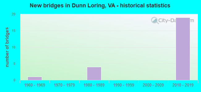
- New bridges - historical statistics
- 11960-1969
- 41980-1989
- 192010-2019
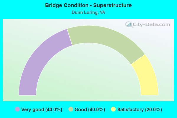
- Bridge Condition - Superstructure
- 40.0%Very good
- 40.0%Good
- 20.0%Satisfactory
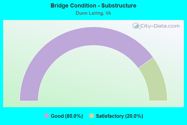
- Bridge Condition - Substructure
- 80.0%Good
- 20.0%Satisfactory
Find on map >> Show street view
Structure Number: 6916, Location: 00.25FR650/00.10TO7 (Lat: 38.911647, Lng: -77.220547), Route carried "on" structure: County highway 927, Year Built: 1986, Status: Open, Structure Length: 16.82m (55.18ft), Average Daily Traffic: 9,783 (year 2020), Truck Traffic: 1%, Average Future Daily Traffic: 10,761 (year 2040), Design Load: HS 20, Features Intersected: RTE 7 - LEESBURG PIKE, Facility Carried by Structure: TOWERS CRESENT DR.
Minimum Vertical Clearance: 30+ m (98+ ft), Kilometerpoint: 0.064, Lanes on structure: 4, Lanes under structure: 8, Owner: State Highway Agency, Approaching Roadway Width: 14.6m (47.9ft), Skew: 1 degrees, Material/Design: Steel continuous, Design/Construction: Stringer/Multi-beam, Number Of Spans In Main Unit: 5, Length of Maximum Span: 40.5m (132.9ft), Curb or Sidewalk Widths: Left: 0.0m, Right: 1.5m (4.9ft), Curb-To-Curb Width: 14.6m (47.9ft), Out-to-Out Width: 17.1m (56.1ft)
Condition: Deck: Good, Superstructure: Satisfactory, Substructure: Satisfactory, Operating Rating: 64.9 metric tons, Method Used To Determine Operating Rating: Load and Resistance Factor (LRFR), Inventory Rating: 50.0 metric tons, Method Used To Determine Inventory Rating: Load and Resistance Factor (LRFR), Structural Evaluation: Equal to present minimum criteria, Deck Geometry: High priority of replacement, Underclear: Meets minimum limits, Approach Roadway Alignment: Equal to present desirable criteria, Length Of Structure Improvement: 1.52m (4.99ft), Designated Inspection Frequency: Every 24 months, Inspection Date: Febuary 2021, Bridge Improvement Cost: $100,000, Roadway Improvement Cost: $41,000, Total Project Cost: $150,000 ( Estimate for 2015), Deck Structure Type: Concrete Cast-file-Place, Wearing Surface/Protective System: Deck Protection: Epoxy Coated Reinforcing
Find on map >> Show street view
Structure Number: 6955, Location: 00.10FR2417/00.05TO2408 (Lat: 38.884606, Lng: -77.236406), Route carried "on" structure: County highway 2401, Year Built: 1964, Status: Open, Structure Length: 0.67m (2.20ft), Average Daily Traffic: 2,496 (year 2020), Truck Traffic: 1%, Average Future Daily Traffic: 2,746 (year 2040), Design Load: HS 20, Features Intersected: LONG BRANCH, Facility Carried by Structure: COTTAGE STREET
Minimum Vertical Clearance: 30+ m (98+ ft), Kilometerpoint: 0.965, Lanes on structure: 2, Owner: State Highway Agency, Approaching Roadway Width: 13.4m (44.0ft), Skew: 1 degrees, Material/Design: Concrete, Design/Construction: Culvert, Number Of Spans In Main Unit: 2, Length of Maximum Span: 3.4m (11.2ft)
Condition: Channel: Fair, Culverts: Satisfactory, Operating Rating: 84.4 metric tons, Method Used To Determine Operating Rating: Load Factor (LF), Inventory Rating: 49.9 metric tons, Method Used To Determine Inventory Rating: Load Factor (LF), Structural Evaluation: Equal to present minimum criteria, Waterway Adequacy: Somewhat better than minimum adequacy, Approach Roadway Alignment: Equal to present minimum criteria, Length Of Structure Improvement: 0.30m (0.98ft), Designated Inspection Frequency: Every 24 months, Inspection Date: Febuary 2021, Bridge Improvement Cost: $1,000, Roadway Improvement Cost: $1,000, Total Project Cost: $3,000 ( Estimate for 2015)
Find on map >> Show street view
Structure Number: 28659, Location: 00.50fr650 01.00to7 (Lat: 38.894156, Lng: -77.216111), Route carried "on" structure: Alternate County highway 695, Year Built: 2011, Status: Open, Structure Length: 11.20m (36.75ft), Average Daily Traffic: 8,147 (year 2020), Truck Traffic: 1%, Average Future Daily Traffic: 11,406 (year 2040), Design Load: HS 20, Features Intersected: I-495, Facility Carried by Structure: IDYLWOOD RD.
Minimum Vertical Clearance: 30.18m (99.02ft), Kilometerpoint: 0.000, Lanes on structure: 2, Lanes under structure: 14, Owner: State Highway Agency, Approaching Roadway Width: 8.5m (27.9ft), Skew: 4 degrees, Material/Design: Steel continuous, Design/Construction: Stringer/Multi-beam, Number Of Spans In Main Unit: 2, Length of Maximum Span: 56.7m (186.0ft), Curb or Sidewalk Widths: Left: 1.7m (5.6ft), Right: 1.7m (5.6ft), Curb-To-Curb Width: 8.5m (27.9ft), Out-to-Out Width: 12.4m (40.7ft)
Condition: Deck: Good, Superstructure: Good, Substructure: Good, Operating Rating: 58.1 metric tons, Method Used To Determine Operating Rating: Load and Resistance Factor (LRFR), Inventory Rating: 44.5 metric tons, Method Used To Determine Inventory Rating: Load and Resistance Factor (LRFR), Structural Evaluation: Better than present minimum criteria, Deck Geometry: Meets minimum limits, Underclear: Somewhat better than minimum adequacy, Approach Roadway Alignment: Better than present minimum criteria, Length Of Structure Improvement: 0.30m (0.98ft), Designated Inspection Frequency: Every 24 months, Inspection Date: Febuary 2021, Bridge Improvement Cost: $1,000, Roadway Improvement Cost: $1,000, Total Project Cost: $3,000 ( Estimate for 2015), Deck Structure Type: Concrete Cast-file-Place, Wearing Surface/Protective System: Wearing Surface: Monolithic Concrete, Deck Protection: Epoxy Coated Reinforcing
Find on map >> Show street view
Structure Number: 2866, Location: 00.17FR1263/00.10TO3925 (Lat: 38.898239, Lng: -77.215200), Route carried "on" structure: County highway 769, Year Built: 2010, Status: Open, Structure Length: 8.03m (26.35ft), Average Daily Traffic: 3,069 (year 2011), Average Future Daily Traffic: 4,727 (year 2040), Design Load: HS 20, Features Intersected: I-495 & HOT LANES, Facility Carried by Structure: OAK ST.
Minimum Vertical Clearance: 30.18m (99.02ft), Kilometerpoint: 0.000, Lanes on structure: 2, Lanes under structure: 13, Owner: State Highway Agency, Approaching Roadway Width: 9.1m (29.9ft), Material/Design: Steel continuous, Design/Construction: Stringer/Multi-beam, Number Of Spans In Main Unit: 2, Length of Maximum Span: 39.9m (130.9ft), Curb or Sidewalk Widths: Left: 1.7m (5.6ft), Right: 0.0m, Curb-To-Curb Width: 7.3m (24.0ft), Out-to-Out Width: 12.5m (41.0ft)
Condition: Deck: Good, Superstructure: Good, Substructure: Good, Operating Rating: 79.8 metric tons, Method Used To Determine Operating Rating: Load and Resistance Factor (LRFR), Inventory Rating: 61.7 metric tons, Method Used To Determine Inventory Rating: Load and Resistance Factor (LRFR), Structural Evaluation: Better than present minimum criteria, Deck Geometry: High priority of replacement, Underclear: Equal to present minimum criteria, Approach Roadway Alignment: Equal to present desirable criteria, Length Of Structure Improvement: 0.30m (0.98ft), Designated Inspection Frequency: Every 24 months, Inspection Date: August 2020, Bridge Improvement Cost: $10,000, Roadway Improvement Cost: $10,000, Total Project Cost: $25,000 ( Estimate for 2014), Deck Structure Type: Concrete Cast-file-Place, Wearing Surface/Protective System: Wearing Surface: Integral Concrete, Deck Protection: Epoxy Coated Reinforcing
Find on map >> Show street view
Structure Number: 28678, Location: 01.16fr695 00.55to650 (Lat: 38.910836, Lng: -77.218572), Route carried "on" structure: US 7, Year Built: 2010, Status: Open, Structure Length: 15.67m (51.41ft), Average Daily Traffic: 64,104 (year 2020), Truck Traffic: 1%, Average Future Daily Traffic: 79,233 (year 2040), Design Load: HS 20, Features Intersected: 495 MAINLINE, Facility Carried by Structure: Leesburg Pike
Minimum Vertical Clearance: 30+ m (98+ ft), Kilometerpoint: 0.000, Lanes on structure: 9, Lanes under structure: 15, Base Highway Network: Yes, Owner: State Highway Agency, Approaching Roadway Width: 17.1m (56.1ft), Skew: 23 degrees, Material/Design: Steel continuous, Design/Construction: Stringer/Multi-beam, Number Of Spans In Main Unit: 4, Length of Maximum Span: 54.9m (180.1ft), Curb or Sidewalk Widths: Left: 3.2m (10.5ft), Right: 3.2m (10.5ft), Curb-To-Curb Width: 16.5m (54.1ft), Out-to-Out Width: 48.2m (158.1ft)
Condition: Deck: Good, Superstructure: Very good, Substructure: Good, Operating Rating: 51.0 metric tons, Method Used To Determine Operating Rating: Load and Resistance Factor (LRFR), Inventory Rating: 39.3 metric tons, Method Used To Determine Inventory Rating: Load and Resistance Factor (LRFR), Structural Evaluation: Better than present minimum criteria, Deck Geometry: High priority of replacement, Underclear: High priority of corrective action, Approach Roadway Alignment: Equal to present desirable criteria, Length Of Structure Improvement: 3.05m (10.01ft), Designated Inspection Frequency: Every 24 months, Inspection Date: July 2020, Bridge Improvement Cost: $1,000, Roadway Improvement Cost: $1,000, Total Project Cost: $3,000 ( Estimate for 2014), Deck Structure Type: Concrete Cast-file-Place, Wearing Surface/Protective System: Wearing Surface: Monolithic Concrete, Deck Protection: Epoxy Coated Reinforcing
Find on map >> Show street view
Structure Number: 28679, Location: 023FR 495 NB /0.01TO 7 (Lat: 38.908667, Lng: -77.217333), Route carried "on" structure: Ramp Other road 495, Year Built: 2012, Status: Open, Structure Length: 16.40m (53.81ft), Average Daily Traffic: 18,000 (year 2012), Truck Traffic: 1%, Average Future Daily Traffic: 28,000 (year 2034), Design Load: HS 20, Features Intersected: I-495NB, Facility Carried by Structure: RAMP LEWSH & LSEWH
Minimum Vertical Clearance: 30.18m (99.02ft), Kilometerpoint: 0.000, Lanes on structure: 3, Lanes under structure: 7, Toll: On toll road, Owner: State Highway Agency, Maintenance Responsibility: Private, Approaching Roadway Width: 6.7m (22.0ft), Skew: 30 degrees, Material/Design: Steel continuous, Design/Construction: Stringer/Multi-beam, Number Of Spans In Main Unit: 4, Length of Maximum Span: 48.0m (157.5ft), Curb-To-Curb Width: 4.9m (16.1ft), Out-to-Out Width: 17.7m (58.1ft)
Condition: Deck: Good, Superstructure: Very good, Substructure: Good, Operating Rating: 89.8 metric tons, Method Used To Determine Operating Rating: Load and Resistance Factor (LRFR), Inventory Rating: 82.6 metric tons, Method Used To Determine Inventory Rating: Load and Resistance Factor (LRFR), Structural Evaluation: Better than present minimum criteria, Deck Geometry: High priority of replacement, Underclear: Meets minimum limits, Approach Roadway Alignment: Better than present minimum criteria, Length Of Structure Improvement: 0.30m (0.98ft), Designated Inspection Frequency: Every 24 months, Critical Feature Inspection Frequency: Every 24 months, Inspection Date: September 2020, Critical Feature Inspection Date: September 2021, Bridge Improvement Cost: $1,000, Roadway Improvement Cost: $1,000, Total Project Cost: $3,000 ( Estimate for 2014), Deck Structure Type: Concrete Cast-file-Place, Wearing Surface/Protective System: Wearing Surface: Monolithic Concrete, Deck Protection: Epoxy Coated Reinforcing
Find on map >> Show street view
Structure Number: 6916, Location: 00.25FR650/00.10TO7 (Lat: 38.911647, Lng: -77.220547), Route carried "under" structure: State highway 7, Year Built: 1986, Structure Length: 0. m, Average Daily Traffic: 61,042 (year 2008), Truck Traffic: 1%, Features Intersected: RTE 7 - LEESBURG PIKE, Facility Carried by Structure: TOWERS CRESENT DR.
Minimum Vertical Clearance: 5.16m (16.93ft), Kilometerpoint: 97.135, Lanes on structure: 4, Lanes under structure: 3, Material/Design: Steel continuous, Design/Construction: Stringer/Multi-beam, Length of Maximum Span: 40.5m (132.9ft)
Find on map >> Show street view
Structure Number: 6916, Location: 00.25FR650/00.10TO7 (Lat: 38.911647, Lng: -77.220547), Route carried "under" structure: State highway 7, Year Built: 1986, Structure Length: 0. m, Average Daily Traffic: 61,042 (year 2008), Truck Traffic: 1%, Features Intersected: RTE 7 - LEESBURG PIKE, Facility Carried by Structure: TOWERS CRESENT DR.
Minimum Vertical Clearance: 5.11m (16.77ft), Kilometerpoint: 97.135, Lanes on structure: 4, Lanes under structure: 4, Material/Design: Steel continuous, Design/Construction: Stringer/Multi-beam, Length of Maximum Span: 40.5m (132.9ft)
Find on map >> Show street view
Structure Number: 6916, Location: 00.25FR650/00.10TO7 (Lat: 38.911647, Lng: -77.220547), Route carried "under" structure: Ramp State highway 495, Year Built: 1986, Structure Length: 0. m, Average Daily Traffic: 61,042 (year 2008), Truck Traffic: 1%, Features Intersected: RTE 7 - LEESBURG PIKE, Facility Carried by Structure: TOWERS CRESENT DR.
Minimum Vertical Clearance: 5.59m (18.34ft), Kilometerpoint: 97.457, Lanes on structure: 4, Lanes under structure: 1, Material/Design: Steel continuous, Design/Construction: Stringer/Multi-beam, Length of Maximum Span: 40.5m (132.9ft)
Find on map >> Show street view
Structure Number: 28659, Location: 00.50fr650 01.00to7 (Lat: 38.894156, Lng: -77.216111), Route carried "under" structure: Alternate Other road 495, Year Built: 2011, Structure Length: 0. m, Average Daily Traffic: 11,000 (year 2012), Truck Traffic: 2%, Features Intersected: I-495, Facility Carried by Structure: IDYLWOOD RD.
Minimum Vertical Clearance: 6.73m (22.08ft), Kilometerpoint: 0.000, Lanes on structure: 2, Lanes under structure: 2, Toll: On toll road, Material/Design: Steel continuous, Design/Construction: Stringer/Multi-beam, Length of Maximum Span: 56.7m (186.0ft)
Find on map >> Show street view
Structure Number: 28659, Location: 00.50fr650 01.00to7 (Lat: 38.894156, Lng: -77.216111), Route carried "under" structure: Interstate 495, Year Built: 2011, Structure Length: 0. m, Average Daily Traffic: 122,000 (year 2011), Truck Traffic: 8%, Features Intersected: I-495, Facility Carried by Structure: IDYLWOOD RD.
Minimum Vertical Clearance: 6.15m (20.18ft), Kilometerpoint: 0.000, Lanes on structure: 2, Lanes under structure: 5, Material/Design: Steel continuous, Design/Construction: Stringer/Multi-beam, Length of Maximum Span: 56.7m (186.0ft)
Find on map >> Show street view
Structure Number: 28659, Location: 00.50fr650 01.00to7 (Lat: 38.894156, Lng: -77.216111), Route carried "under" structure: Interstate 495, Year Built: 2011, Structure Length: 0. m, Average Daily Traffic: 124,000 (year 2011), Truck Traffic: 15%, Features Intersected: I-495, Facility Carried by Structure: IDYLWOOD RD.
Minimum Vertical Clearance: 6.07m (19.91ft), Kilometerpoint: 0.000, Lanes on structure: 2, Lanes under structure: 5, Material/Design: Steel continuous, Design/Construction: Stringer/Multi-beam, Length of Maximum Span: 56.7m (186.0ft)
Find on map >> Show street view
Structure Number: 28659, Location: 00.50fr650 01.00to7 (Lat: 38.894156, Lng: -77.216111), Route carried "under" structure: Alternate Other road 495, Year Built: 2011, Structure Length: 0. m, Average Daily Traffic: 12,000 (year 2012), Truck Traffic: 2%, Features Intersected: I-495, Facility Carried by Structure: IDYLWOOD RD.
Minimum Vertical Clearance: 6.27m (20.57ft), Kilometerpoint: 0.000, Lanes on structure: 2, Lanes under structure: 2, Toll: On toll road, Material/Design: Steel continuous, Design/Construction: Stringer/Multi-beam, Length of Maximum Span: 56.7m (186.0ft)
Find on map >> Show street view
Structure Number: 2866, Location: 00.17FR1263/00.10TO3925 (Lat: 38.898239, Lng: -77.215200), Route carried "under" structure: Interstate 495, Year Built: 2010, Structure Length: 0. m, Average Daily Traffic: 150,000 (year 2010), Truck Traffic: 2%, Features Intersected: I-495 & HOT LANES, Facility Carried by Structure: OAK ST.
Minimum Vertical Clearance: 5.87m (19.26ft), Kilometerpoint: 0.000, Lanes on structure: 2, Lanes under structure: 5, Material/Design: Steel continuous, Design/Construction: Stringer/Multi-beam, Length of Maximum Span: 39.9m (130.9ft)
Find on map >> Show street view
Structure Number: 2866, Location: 00.17FR1263/00.10TO3925 (Lat: 38.898239, Lng: -77.215200), Route carried "under" structure: Interstate 495, Year Built: 2010, Structure Length: 0. m, Average Daily Traffic: 150,000 (year 2010), Truck Traffic: 2%, Features Intersected: I-495 & HOT LANES, Facility Carried by Structure: OAK ST.
Minimum Vertical Clearance: 5.41m (17.75ft), Kilometerpoint: 0.000, Lanes on structure: 2, Lanes under structure: 2, Toll: On toll road, Material/Design: Steel continuous, Design/Construction: Stringer/Multi-beam, Length of Maximum Span: 39.9m (130.9ft)
Find on map >> Show street view
Structure Number: 2866, Location: 00.17FR1263/00.10TO3925 (Lat: 38.898239, Lng: -77.215200), Route carried "under" structure: Interstate 495, Year Built: 2010, Structure Length: 0. m, Average Daily Traffic: 150,000 (year 2010), Truck Traffic: 2%, Features Intersected: I-495 & HOT LANES, Facility Carried by Structure: OAK ST.
Minimum Vertical Clearance: 6.17m (20.24ft), Kilometerpoint: 0.000, Lanes on structure: 2, Lanes under structure: 2, Toll: On toll road, Material/Design: Steel continuous, Design/Construction: Stringer/Multi-beam, Length of Maximum Span: 39.9m (130.9ft)
Find on map >> Show street view
Structure Number: 2866, Location: 00.17FR1263/00.10TO3925 (Lat: 38.898239, Lng: -77.215200), Route carried "under" structure: Interstate 495, Year Built: 2010, Structure Length: 0. m, Average Daily Traffic: 150,000 (year 2010), Truck Traffic: 2%, Features Intersected: I-495 & HOT LANES, Facility Carried by Structure: OAK ST.
Minimum Vertical Clearance: 5.36m (17.59ft), Kilometerpoint: 0.000, Lanes on structure: 2, Lanes under structure: 4, Material/Design: Steel continuous, Design/Construction: Stringer/Multi-beam, Length of Maximum Span: 39.9m (130.9ft)
Find on map >> Show street view
Structure Number: 28678, Location: 01.16fr695 00.55to650 (Lat: 38.910836, Lng: -77.218572), Route carried "under" structure: Ramp Interstate 495, Year Built: 2010, Structure Length: 0. m, Average Daily Traffic: 24,200 (year 2010), Truck Traffic: 6%, Features Intersected: 495 MAINLINE, Facility Carried by Structure: Leesburg Pike
Minimum Vertical Clearance: 5.72m (18.77ft), Kilometerpoint: 0.000, Lanes on structure: 9, Lanes under structure: 2, Material/Design: Steel continuous, Design/Construction: Stringer/Multi-beam, Length of Maximum Span: 54.9m (180.1ft)
Find on map >> Show street view
Structure Number: 28678, Location: 01.16fr695 00.55to650 (Lat: 38.910836, Lng: -77.218572), Route carried "under" structure: Interstate 495, Year Built: 2010, Structure Length: 0. m, Average Daily Traffic: 149,500 (year 2010), Truck Traffic: 15%, Features Intersected: 495 MAINLINE, Facility Carried by Structure: Leesburg Pike
Minimum Vertical Clearance: 5.69m (18.67ft), Kilometerpoint: 0.000, Lanes on structure: 9, Lanes under structure: 6, Material/Design: Steel continuous, Design/Construction: Stringer/Multi-beam, Length of Maximum Span: 54.9m (180.1ft)
Find on map >> Show street view
Structure Number: 28678, Location: 01.16fr695 00.55to650 (Lat: 38.910836, Lng: -77.218572), Route carried "under" structure: Ramp Interstate 495, Year Built: 2010, Structure Length: 0. m, Average Daily Traffic: 15,000 (year 2010), Truck Traffic: 5%, Features Intersected: 495 MAINLINE, Facility Carried by Structure: Leesburg Pike
Minimum Vertical Clearance: 5.71m (18.73ft), Kilometerpoint: 0.000, Lanes on structure: 9, Lanes under structure: 1, Material/Design: Steel continuous, Design/Construction: Stringer/Multi-beam, Length of Maximum Span: 54.9m (180.1ft)
Find on map >> Show street view
Structure Number: 28678, Location: 01.16fr695 00.55to650 (Lat: 38.910836, Lng: -77.218572), Route carried "under" structure: Interstate 495, Year Built: 2010, Structure Length: 0. m, Average Daily Traffic: 147,700 (year 2010), Truck Traffic: 15%, Features Intersected: 495 MAINLINE, Facility Carried by Structure: Leesburg Pike
Minimum Vertical Clearance: 5.84m (19.16ft), Kilometerpoint: 0.000, Lanes on structure: 9, Lanes under structure: 6, Material/Design: Steel continuous, Design/Construction: Stringer/Multi-beam, Length of Maximum Span: 54.9m (180.1ft)
Find on map >> Show street view
Structure Number: 28679, Location: 023FR 495 NB /0.01TO 7 (Lat: 38.908667, Lng: -77.217333), Route carried "under" structure: Alternate Other road 495, Year Built: 2012, Structure Length: 0. m, Average Daily Traffic: 26,000 (year 2012), Truck Traffic: 1%, Features Intersected: I-495NB, Facility Carried by Structure: RAMP LEWSH & LSEWH
Minimum Vertical Clearance: 6.86m (22.51ft), Kilometerpoint: 0.000, Lanes on structure: 3, Lanes under structure: 2, Toll: On toll road, Material/Design: Steel continuous, Design/Construction: Stringer/Multi-beam, Length of Maximum Span: 48.0m (157.5ft)
Find on map >> Show street view
Structure Number: 28679, Location: 023FR 495 NB /0.01TO 7 (Lat: 38.908667, Lng: -77.217333), Route carried "under" structure: Interstate 495, Year Built: 2012, Structure Length: 0. m, Average Daily Traffic: 72,000 (year 2012), Truck Traffic: 15%, Features Intersected: I-495NB, Facility Carried by Structure: RAMP LEWSH & LSEWH
Minimum Vertical Clearance: 6.38m (20.93ft), Kilometerpoint: 0.000, Lanes on structure: 3, Lanes under structure: 4, Material/Design: Steel continuous, Design/Construction: Stringer/Multi-beam, Length of Maximum Span: 48.0m (157.5ft)
Find on map >> Show street view
Structure Number: 28679, Location: 023FR 495 NB /0.01TO 7 (Lat: 38.908667, Lng: -77.217333), Route carried "under" structure: Ramp Interstate 495, Year Built: 2012, Structure Length: 0. m, Average Daily Traffic: 17,000 (year 2012), Truck Traffic: 10%, Features Intersected: I-495NB, Facility Carried by Structure: RAMP LEWSH & LSEWH
Minimum Vertical Clearance: 5.46m (17.91ft), Kilometerpoint: 0.000, Lanes on structure: 3, Lanes under structure: 1, Material/Design: Steel continuous, Design/Construction: Stringer/Multi-beam, Length of Maximum Span: 48.0m (157.5ft)