Bridge Statistics for Dixon, California (CA)
Condition, Traffic, Stress, Structural Evaluation, Project Costs
- National Bridge Inventory (NBI) Statistics
- 27Number of bridges
- 259ft / 79.1mTotal length
- $3,443,000Total costs
- 813,387Total average daily traffic
- 67,286Total average daily truck traffic
- National Bridge Inventory (NBI) Registered Bridges for Dixon
- No street view available for this location
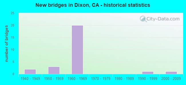
- New bridges - historical statistics
- 21940-1949
- 31950-1959
- 201960-1969
- 11990-1999
- 12000-2009


- Bridge Condition - Deck
- 61.5%Good
- 7.7%Satisfactory
- 23.1%Fair
- 7.7%Poor

- Bridge Condition - Superstructure
- 84.6%Good
- 15.4%Fair

- Bridge Condition - Substructure
- 76.9%Good
- 15.4%Fair
- 7.7%Imminent failure

- Bridge Condition - Channel
- 11.1%Excellent
- 11.1%Very good
- 11.1%Good
- 55.6%Satisfactory
- 11.1%Fair
Find on map >> Show street view
Structure Number: 23 0076, Location: 04-SOL-113-11.58 (Lat: 38.336397, Lng: -121.823200), Route carried "on" structure: State highway 113, Year Built: 1964, Status: Open, Structure Length: 2.59m (8.50ft), Average Daily Traffic: 4,900 (year 2009), Truck Traffic: 6%, Average Future Daily Traffic: 6,474 (year 2040), Design Load: HS 20, Features Intersected: NEW ALAMO CREEK CHANNEL
Minimum Vertical Clearance: 30+ m (98+ ft), Kilometerpoint: 11.580, Lanes on structure: 2, Base Highway Network: Yes (Inventory Route: 1, Subroute: 1), Owner: State Highway Agency, Approaching Roadway Width: 7.0m (23.0ft), Material/Design: Concrete continuous, Design/Construction: Slab, Number Of Spans In Main Unit: 3, Length of Maximum Span: 8.5m (27.9ft), Curb or Sidewalk Widths: Left: 0.6m (2.0ft), Right: 0.6m (2.0ft), Curb-To-Curb Width: 8.5m (27.9ft), Out-to-Out Width: 10.4m (34.1ft)
Condition: Deck: Good, Superstructure: Good, Substructure: Good, Channel: Very good, Operating Rating: 59.0 metric tons, Method Used To Determine Operating Rating: Load Factor (LF), Inventory Rating: 35.3 metric tons, Method Used To Determine Inventory Rating: Load Factor (LF), Structural Evaluation: Better than present minimum criteria, Deck Geometry: Meets minimum limits, Waterway Adequacy: Equal to present desirable criteria, Approach Roadway Alignment: Equal to present desirable criteria, Designated Inspection Frequency: Every 24 months, Inspection Date: November 2020, Deck Structure Type: Concrete Cast-file-Place, Wearing Surface/Protective System: Wearing Surface: Bituminous
Find on map >> Show street view
Structure Number: 23 0084L, Location: 04-SOL-080-34.48 (Lat: 38.435056, Lng: -121.872772), Route carried "on" structure: Interstate 80, Year Built: 1946, Year Reconstructed: 1963, Status: Open, Structure Length: 3.30m (10.83ft), Average Daily Traffic: 81,500 (year 2009), Truck Traffic: 9%, Average Future Daily Traffic: 83,223 (year 2040), Design Load: HS 20, Features Intersected: MC CUNE CREEK
Minimum Vertical Clearance: 30+ m (98+ ft), Kilometerpoint: 34.480, Lanes on structure: 3, Base Highway Network: Yes (, Subroute: 2), Owner: State Highway Agency, Approaching Roadway Width: 17.4m (57.1ft), Skew: 4 degrees, Material/Design: Concrete continuous, Design/Construction: Slab, Number Of Spans In Main Unit: 4, Length of Maximum Span: 9.1m (29.9ft), Curb-To-Curb Width: 15.5m (50.9ft), Out-to-Out Width: 16.4m (53.8ft)
Condition: Deck: Good, Superstructure: Good, Substructure: Fair, Channel: Satisfactory, Operating Rating: 41.5 metric tons, Method Used To Determine Operating Rating: Load Factor (LF), Inventory Rating: 24.9 metric tons, Method Used To Determine Inventory Rating: Load Factor (LF), Structural Evaluation: Somewhat better than minimum adequacy, Deck Geometry: Somewhat better than minimum adequacy, Waterway Adequacy: Superior to present desirable criteria, Approach Roadway Alignment: Equal to present desirable criteria, Designated Inspection Frequency: Every 24 months, Inspection Date: November 2020, Deck Structure Type: Concrete Cast-file-Place
Find on map >> Show street view
Structure Number: 23 0084R, Location: 04-SOL-080-34.48 (Lat: 38.434772, Lng: -121.872756), Route carried "on" structure: Interstate 80, Year Built: 1946, Year Reconstructed: 1963, Status: Open, Structure Length: 3.30m (10.83ft), Average Daily Traffic: 81,500 (year 2009), Truck Traffic: 9%, Average Future Daily Traffic: 83,223 (year 2040), Design Load: HS 20, Features Intersected: MC CUNE CREEK
Minimum Vertical Clearance: 30+ m (98+ ft), Kilometerpoint: 34.480, Lanes on structure: 3, Base Highway Network: Yes (, Subroute: 2), Owner: State Highway Agency, Approaching Roadway Width: 17.4m (57.1ft), Skew: 4 degrees, Material/Design: Concrete continuous, Design/Construction: Slab, Number Of Spans In Main Unit: 4, Length of Maximum Span: 9.1m (29.9ft), Curb-To-Curb Width: 15.5m (50.9ft), Out-to-Out Width: 16.4m (53.8ft)
Condition: Deck: Good, Superstructure: Good, Substructure: Good, Channel: Satisfactory, Operating Rating: 41.5 metric tons, Method Used To Determine Operating Rating: Load Factor (LF), Inventory Rating: 24.9 metric tons, Method Used To Determine Inventory Rating: Load Factor (LF), Structural Evaluation: Equal to present minimum criteria, Deck Geometry: Somewhat better than minimum adequacy, Waterway Adequacy: Equal to present desirable criteria, Approach Roadway Alignment: Equal to present desirable criteria, Designated Inspection Frequency: Every 24 months, Inspection Date: November 2020, Deck Structure Type: Concrete Cast-file-Place
Find on map >> Show street view
Structure Number: 23 015, Location: 04-SOL-080-8.10 (Lat: 38.169617, Lng: -122.200456), Route carried "on" structure: County highway , Year Built: 1963, Status: Open, Structure Length: 8.01m (26.28ft), Average Daily Traffic: 3,960 (year 1997), Truck Traffic: 10%, Average Future Daily Traffic: 5,362 (year 2041), Design Load: H 20, Features Intersected: INTERSTATE 80, Facility Carried by Structure: AMERICAN CANYON RD
Minimum Vertical Clearance: 30+ m (98+ ft), Kilometerpoint: 0.000, Lanes on structure: 2, Lanes under structure: 8, Owner: State Highway Agency, Approaching Roadway Width: 8.6m (28.2ft), Material/Design: Prestressed concrete, Design/Construction: Stringer/Multi-beam, Number Of Spans In Main Unit: 4, Length of Maximum Span: 27.4m (89.9ft), Curb or Sidewalk Widths: Left: 0.6m (2.0ft), Right: 0.6m (2.0ft), Curb-To-Curb Width: 8.6m (28.2ft), Out-to-Out Width: 10.4m (34.1ft)
Condition: Deck: Good, Superstructure: Good, Substructure: Good, Operating Rating: 43.1 metric tons, Method Used To Determine Operating Rating: Load and Resistance Factor Rating (LRFR) rating reported by rating factor(RF) method using HL-93 loadings, Inventory Rating: 31.8 metric tons, Method Used To Determine Inventory Rating: Load and Resistance Factor Rating (LRFR) rating reported by rating factor(RF) method using HL-93 loadings, Structural Evaluation: Better than present minimum criteria, Deck Geometry: Meets minimum limits, Underclear: Somewhat better than minimum adequacy, Approach Roadway Alignment: Superior to present desirable criteria, Designated Inspection Frequency: Every 24 months, Inspection Date: January 2021, Deck Structure Type: Concrete Cast-file-Place
Find on map >> Show street view
Structure Number: 23 0151, Location: 04-SOL-080-35.55-DXN (Lat: 38.445833, Lng: -121.859400), Route carried "on" structure: County highway , Year Built: 1963, Status: Open, Structure Length: 11.54m (37.86ft), Average Daily Traffic: 2,617 (year 2002), Truck Traffic: 2%, Average Future Daily Traffic: 3,685 (year 2038), Design Load: HS 20+Mod, Features Intersected: INTERSTATE 80 & RAMPS, Facility Carried by Structure: DIXON AVENUE
Minimum Vertical Clearance: 30+ m (98+ ft), Kilometerpoint: 0.000, Lanes on structure: 2, Lanes under structure: 10, Owner: State Highway Agency, Approaching Roadway Width: 12.2m (40.0ft), Skew: 4 degrees, Material/Design: Steel, Design/Construction: Stringer/Multi-beam, Number Of Spans In Main Unit: 4, Length of Maximum Span: 41.8m (137.1ft), Curb-To-Curb Width: 9.7m (31.8ft), Out-to-Out Width: 10.6m (34.8ft)
Condition: Deck: Fair, Superstructure: Good, Substructure: Good, Operating Rating: 90.4 metric tons, Method Used To Determine Operating Rating: Load Factor (LF), Inventory Rating: 54.1 metric tons, Method Used To Determine Inventory Rating: Load Factor (LF), Structural Evaluation: Better than present minimum criteria, Deck Geometry: Meets minimum limits, Underclear: Somewhat better than minimum adequacy, Approach Roadway Alignment: Equal to present desirable criteria, Designated Inspection Frequency: Every 24 months, Other Special Inspection Frequency: Every 48 months, Inspection Date: November 2020, Other Special Inspection Date: January 2021, Deck Structure Type: Concrete Cast-file-Place
Find on map >> Show street view
Structure Number: 23 0152, Location: 04-SOL-080-36.90-DXN (Lat: 38.460122, Lng: -121.841022), Route carried "on" structure: County highway , Year Built: 1963, Status: Open, Structure Length: 11.15m (36.58ft), Average Daily Traffic: 470 (year 2000), Truck Traffic: 2%, Average Future Daily Traffic: 646 (year 2042), Design Load: HS 20+Mod, Features Intersected: INTERSTATE 80 & RAMPS, Facility Carried by Structure: PITT SCHOOL ROAD
Minimum Vertical Clearance: 30+ m (98+ ft), Kilometerpoint: 0.000, Lanes on structure: 2, Lanes under structure: 8, Owner: State Highway Agency, Approaching Roadway Width: 14.0m (45.9ft), Skew: 4 degrees, Material/Design: Steel, Design/Construction: Stringer/Multi-beam, Number Of Spans In Main Unit: 4, Length of Maximum Span: 37.9m (124.3ft), Curb-To-Curb Width: 9.7m (31.8ft), Out-to-Out Width: 10.6m (34.8ft)
Condition: Deck: Satisfactory, Superstructure: Good, Substructure: Good, Operating Rating: 60.9 metric tons, Method Used To Determine Operating Rating: Load Factor (LF), Inventory Rating: 36.6 metric tons, Method Used To Determine Inventory Rating: Load Factor (LF), Structural Evaluation: Better than present minimum criteria, Deck Geometry: Equal to present minimum criteria, Underclear: Equal to present minimum criteria, Approach Roadway Alignment: Equal to present desirable criteria, Designated Inspection Frequency: Every 24 months, Other Special Inspection Frequency: Every 48 months, Inspection Date: November 2020, Other Special Inspection Date: January 2021, Deck Structure Type: Concrete Cast-file-Place
Find on map >> Show street view
Structure Number: 23 0153E, Location: 04-SOL-113-21.21-DXN (Lat: 38.472553, Lng: -121.823422), Route carried "on" structure: Ramp State highway 113, Year Built: 1963, Status: Open, Structure Length: 10.30m (33.79ft), Average Daily Traffic: 7,200 (year 2012), Truck Traffic: 5%, Average Future Daily Traffic: 15,354 (year 2038), Design Load: HS 20+Mod, Features Intersected: I-80 & RMPS (@ PM 38.21)
Minimum Vertical Clearance: 30+ m (98+ ft), Kilometerpoint: 21.210, Lanes on structure: 2, Lanes under structure: 8, Base Highway Network: Yes (Inventory Route: 1, Subroute: 1), Owner: State Highway Agency, Approaching Roadway Width: 11.0m (36.1ft), Skew: 2 degrees, Material/Design: Steel, Design/Construction: Stringer/Multi-beam, Number Of Spans In Main Unit: 4, Length of Maximum Span: 34.9m (114.5ft), Curb or Sidewalk Widths: Left: 1.5m (4.9ft), Right: 0.0m, Curb-To-Curb Width: 9.8m (32.2ft), Out-to-Out Width: 12.3m (40.4ft)
Condition: Deck: Good, Superstructure: Good, Substructure: Good, Operating Rating: 82.6 metric tons, Method Used To Determine Operating Rating: Load Factor (LF), Inventory Rating: 49.6 metric tons, Method Used To Determine Inventory Rating: Load Factor (LF), Structural Evaluation: Better than present minimum criteria, Deck Geometry: Equal to present minimum criteria, Underclear: Equal to present minimum criteria, Approach Roadway Alignment: Equal to present desirable criteria, Designated Inspection Frequency: Every 24 months, Critical Feature Inspection Frequency: Every 24 months, Other Special Inspection Frequency: Every 48 months, Inspection Date: November 2020, Critical Feature Inspection Date: December 2020, Other Special Inspection Date: December 2020, Deck Structure Type: Concrete Cast-file-Place, Wearing Surface/Protective System: Wearing Surface: Bituminous
Find on map >> Show street view
Structure Number: 23 0159, Location: 04-SOL-080-39.74-DXN (Lat: 38.489264, Lng: -121.803847), Route carried "on" structure: County highway , Year Built: 1965, Status: Open, Structure Length: 11.64m (38.19ft), Average Daily Traffic: 1,520 (year 1998), Truck Traffic: 2%, Average Future Daily Traffic: 3,123 (year 2042), Design Load: HS 20+Mod, Features Intersected: INTERSTATE 80 & RAMPS, Facility Carried by Structure: PEDRICK ROAD
Minimum Vertical Clearance: 30+ m (98+ ft), Kilometerpoint: 0.000, Lanes on structure: 2, Lanes under structure: 8, Owner: State Highway Agency, Approaching Roadway Width: 12.5m (41.0ft), Skew: 4 degrees, Material/Design: Steel, Design/Construction: Stringer/Multi-beam, Number Of Spans In Main Unit: 4, Length of Maximum Span: 39.2m (128.6ft), Curb or Sidewalk Widths: Left: 0.6m (2.0ft), Right: 1.5m (4.9ft), Curb-To-Curb Width: 8.5m (27.9ft), Out-to-Out Width: 11.3m (37.1ft)
Condition: Deck: Poor, Superstructure: Good, Substructure: Good, Operating Rating: 68.4 metric tons, Method Used To Determine Operating Rating: Load Factor (LF), Inventory Rating: 40.8 metric tons, Method Used To Determine Inventory Rating: Load Factor (LF), Structural Evaluation: Better than present minimum criteria, Deck Geometry: Somewhat better than minimum adequacy, Underclear: Somewhat better than minimum adequacy, Approach Roadway Alignment: Equal to present desirable criteria, Length Of Structure Improvement: 11.64m (38.19ft), Designated Inspection Frequency: Every 24 months, Other Special Inspection Frequency: Every 48 months, Inspection Date: November 2020, Other Special Inspection Date: January 2021, Bridge Improvement Cost: $1,314,000, Roadway Improvement Cost: $262,000, Total Project Cost: $2,207,000 ( Estimate for 2019), Deck Structure Type: Concrete Cast-file-Place, Wearing Surface/Protective System: Wearing Surface: Bituminous
Find on map >> Show street view
Structure Number: 23 0236, Location: 04-SOL-113-11.67 (Lat: 38.337742, Lng: -121.823167), Route carried "on" structure: State highway 113, Year Built: 2001, Status: Open, Structure Length: 4.95m (16.24ft), Average Daily Traffic: 4,900 (year 2009), Truck Traffic: 6%, Average Future Daily Traffic: 6,474 (year 2040), Design Load: HS 20+Mod, Features Intersected: ULATIS CREEK
Minimum Vertical Clearance: 30+ m (98+ ft), Kilometerpoint: 11.670, Lanes on structure: 2, Base Highway Network: Yes (Inventory Route: 1, Subroute: 1), Owner: State Highway Agency, Approaching Roadway Width: 12.0m (39.4ft), Material/Design: Concrete continuous, Design/Construction: Slab, Number Of Spans In Main Unit: 4, Length of Maximum Span: 12.6m (41.3ft), Curb-To-Curb Width: 12.0m (39.4ft), Out-to-Out Width: 12.9m (42.3ft)
Condition: Deck: Fair, Superstructure: Fair, Substructure: Good, Channel: Excellent, Operating Rating: 54.1 metric tons, Method Used To Determine Operating Rating: Assigned rating based on Load Factor Design (LFD) reported in metric tons, Inventory Rating: 32.4 metric tons, Method Used To Determine Inventory Rating: Assigned rating based on Load Factor Design (LFD) reported in metric tons, Structural Evaluation: Somewhat better than minimum adequacy, Deck Geometry: Somewhat better than minimum adequacy, Waterway Adequacy: Better than present minimum criteria, Approach Roadway Alignment: Equal to present desirable criteria, Designated Inspection Frequency: Every 24 months, Inspection Date: November 2020, Deck Structure Type: Concrete Cast-file-Place
Find on map >> Show street view
Structure Number: 23C0036, Location: 1.0 MI W OF I-80 (Lat: 38.445847, Lng: -121.873178), Route carried "on" structure: County highway , Year Built: 1958, Status: Open, Structure Length: 1.58m (5.18ft), Average Daily Traffic: 2,223 (year 2007), Truck Traffic: 10%, Average Future Daily Traffic: 1,744 (year 2041), Design Load: HS 20, Features Intersected: MC CUNE CREEK, Facility Carried by Structure: DIXON AVE WEST
Minimum Vertical Clearance: 30+ m (98+ ft), Kilometerpoint: 0.000, Lanes on structure: 2, Owner: County Highway Agency, Approaching Roadway Width: 6.4m (21.0ft), Skew: 1 degrees, Material/Design: Concrete continuous, Design/Construction: Slab, Number Of Spans In Main Unit: 2, Length of Maximum Span: 7.6m (24.9ft), Curb-To-Curb Width: 12.2m (40.0ft), Out-to-Out Width: 12.3m (40.4ft)
Condition: Deck: Good, Superstructure: Good, Substructure: Good, Channel: Fair, Operating Rating: 45.0 metric tons, Method Used To Determine Operating Rating: Load Factor (LF), Inventory Rating: 26.9 metric tons, Method Used To Determine Inventory Rating: Load Factor (LF), Structural Evaluation: Equal to present minimum criteria, Deck Geometry: Equal to present minimum criteria, Waterway Adequacy: Equal to present minimum criteria, Approach Roadway Alignment: Equal to present desirable criteria, Designated Inspection Frequency: Every 24 months, Inspection Date: March 2021, Deck Structure Type: Concrete Cast-file-Place, Wearing Surface/Protective System: Wearing Surface: Bituminous
Find on map >> Show street view
Structure Number: 23C0088, Location: 1.5 MI W LIBERTY ISLND RD (Lat: 38.358111, Lng: -121.740781), Route carried "on" structure: County highway , Year Built: 1957, Status: Open, Structure Length: 0.79m (2.59ft), Average Daily Traffic: 134 (year 2011), Truck Traffic: 10%, Average Future Daily Traffic: 212 (year 2041), Features Intersected: V DRAIN, Facility Carried by Structure: SWAN RD
Minimum Vertical Clearance: 30+ m (98+ ft), Kilometerpoint: 0.000, Lanes on structure: 2, Owner: County Highway Agency, Approaching Roadway Width: 7.3m (24.0ft), Material/Design: Concrete continuous, Design/Construction: Culvert, Number Of Spans In Main Unit: 2, Length of Maximum Span: 3.7m (12.1ft), Curb-To-Curb Width: 7.3m (24.0ft), Out-to-Out Width: 10.3m (33.8ft)
Condition: Channel: Satisfactory, Culverts: Good, Operating Rating: 40.5 metric tons, Method Used To Determine Operating Rating: Field evaluation and documented engineering judgment, Inventory Rating: 24.3 metric tons, Method Used To Determine Inventory Rating: Field evaluation and documented engineering judgment, Structural Evaluation: Equal to present minimum criteria, Deck Geometry: Somewhat better than minimum adequacy, Waterway Adequacy: Somewhat better than minimum adequacy, Approach Roadway Alignment: Better than present minimum criteria, Designated Inspection Frequency: Every 24 months, Inspection Date: March 2021, Deck Structure Type: Concrete Cast-file-Place, Wearing Surface/Protective System: Wearing Surface: Bituminous
Find on map >> Show street view
Structure Number: 23C0117, Location: 1.4 MI W OF RTE 113 (Lat: 38.358656, Lng: -121.848669), Route carried "on" structure: County highway , Year Built: 1964, Status: Open, Structure Length: 3.96m (12.99ft), Average Daily Traffic: 801 (year 2003), Truck Traffic: 6%, Average Future Daily Traffic: 436 (year 2041), Features Intersected: ULATIS CREEK, Facility Carried by Structure: HAWKINS ROAD
Minimum Vertical Clearance: 30+ m (98+ ft), Kilometerpoint: 0.000, Lanes on structure: 2, Owner: County Highway Agency, Approaching Roadway Width: 7.3m (24.0ft), Material/Design: Concrete continuous, Design/Construction: Slab, Number Of Spans In Main Unit: 4, Length of Maximum Span: 9.1m (29.9ft), Curb-To-Curb Width: 7.9m (25.9ft), Out-to-Out Width: 8.1m (26.6ft)
Condition: Deck: Good, Superstructure: Good, Substructure: Good, Channel: Good, Operating Rating: 72.9 metric tons, Method Used To Determine Operating Rating: Load Factor (LF), Inventory Rating: 43.7 metric tons, Method Used To Determine Inventory Rating: Load Factor (LF), Structural Evaluation: Better than present minimum criteria, Deck Geometry: Somewhat better than minimum adequacy, Waterway Adequacy: Better than present minimum criteria, Approach Roadway Alignment: Equal to present desirable criteria, Designated Inspection Frequency: Every 24 months, Inspection Date: November 2021, Deck Structure Type: Concrete Cast-file-Place, Wearing Surface/Protective System: Wearing Surface: Bituminous
Find on map >> Show street view
Structure Number: 23C0118, Location: 0.3 MI E OF RTE 113 (Lat: 38.329433, Lng: -121.813733), Route carried "on" structure: County highway , Year Built: 1962, Status: Closed, Structure Length: 3.96m (12.99ft), Average Daily Traffic: 255 (year 2003), Truck Traffic: 5%, Average Future Daily Traffic: 114 (year 2041), Features Intersected: ULATIS CREEK, Facility Carried by Structure: MAIN PRAIRIE RD
Minimum Vertical Clearance: 30+ m (98+ ft), Kilometerpoint: 0.000, Lanes on structure: 2, Owner: County Highway Agency, Approaching Roadway Width: 6.1m (20.0ft), Material/Design: Concrete continuous, Design/Construction: Slab, Number Of Spans In Main Unit: 4, Length of Maximum Span: 9.8m (32.2ft), Curb-To-Curb Width: 7.9m (25.9ft), Out-to-Out Width: 8.1m (26.6ft)
Condition: Deck: Fair, Superstructure: Fair, Substructure: Imminent failure, Channel: Satisfactory, Deck Geometry: Somewhat better than minimum adequacy, Waterway Adequacy: Better than present minimum criteria, Approach Roadway Alignment: Equal to present desirable criteria, Bridge Posting: Required (Relationship of Operating Rating to Maximum Legal Load: > 39.9% below), Length Of Structure Improvement: 3.96m (12.99ft), Designated Inspection Frequency: Every 24 months, Inspection Date: March 2021, Bridge Improvement Cost: $736,000, Roadway Improvement Cost: $147,000, Total Project Cost: $1,236,000 ( Estimate for 2017), Deck Structure Type: Concrete Cast-file-Place
Find on map >> Show street view
Structure Number: 23C0194, Location: 0.40 MI E OSAGE RD (Lat: 38.460483, Lng: -121.887144), Route carried "on" structure: County highway , Year Built: 1959, Status: Open, Structure Length: 2.07m (6.79ft), Average Daily Traffic: 407 (year 2004), Truck Traffic: 5%, Average Future Daily Traffic: 567 (year 2041), Features Intersected: MC CUNE CREEK, Facility Carried by Structure: SILVEYVILLE RD
Minimum Vertical Clearance: 30+ m (98+ ft), Kilometerpoint: 0.000, Lanes on structure: 2, Owner: County Highway Agency, Approaching Roadway Width: 6.4m (21.0ft), Material/Design: Concrete continuous, Design/Construction: Slab, Number Of Spans In Main Unit: 3, Length of Maximum Span: 7.9m (25.9ft), Curb-To-Curb Width: 9.1m (29.9ft), Out-to-Out Width: 9.3m (30.5ft)
Condition: Deck: Good, Superstructure: Good, Substructure: Fair, Channel: Satisfactory, Operating Rating: 37.9 metric tons, Method Used To Determine Operating Rating: Field evaluation and documented engineering judgment, Inventory Rating: 22.7 metric tons, Method Used To Determine Inventory Rating: Field evaluation and documented engineering judgment, Structural Evaluation: Somewhat better than minimum adequacy, Deck Geometry: Equal to present minimum criteria, Waterway Adequacy: Better than present minimum criteria, Approach Roadway Alignment: Equal to present desirable criteria, Designated Inspection Frequency: Every 24 months, Inspection Date: March 2021, Deck Structure Type: Concrete Cast-file-Place, Wearing Surface/Protective System: Wearing Surface: Bituminous
Find on map >> Show street view
Structure Number: 23 0151, Location: 04-SOL-080-35.55-DXN (Lat: 38.445833, Lng: -121.859400), Route carried "under" structure: Interstate 80, Year Built: 1963, Structure Length: 0. m, Average Daily Traffic: 117,500 (year 2009), Truck Traffic: 9%, Features Intersected: INTERSTATE 80 & RAMPS, Facility Carried by Structure: DIXON AVENUE
Minimum Vertical Clearance: 5.21m (17.09ft), Kilometerpoint: 35.550, Lanes on structure: 2, Lanes under structure: 8, Material/Design: Steel, Design/Construction: Stringer/Multi-beam, Length of Maximum Span: 41.8m (137.1ft)
Find on map >> Show street view
Structure Number: 23 0151, Location: 04-SOL-080-35.55-DXN (Lat: 38.445833, Lng: -121.859400), Route carried "under" structure: Ramp Interstate 80, Year Built: 1963, Structure Length: 0. m, Average Daily Traffic: 1,750 (year 2012), Truck Traffic: 9%, Features Intersected: INTERSTATE 80 & RAMPS, Facility Carried by Structure: DIXON AVENUE
Minimum Vertical Clearance: 5.05m (16.57ft), Kilometerpoint: 35.550, Lanes on structure: 2, Lanes under structure: 1, Material/Design: Steel, Design/Construction: Stringer/Multi-beam, Length of Maximum Span: 41.8m (137.1ft)
Find on map >> Show street view
Structure Number: 23 0151, Location: 04-SOL-080-35.55-DXN (Lat: 38.445833, Lng: -121.859400), Route carried "under" structure: Ramp Interstate 80, Year Built: 1963, Structure Length: 0. m, Average Daily Traffic: 3,750 (year 2012), Truck Traffic: 9%, Features Intersected: INTERSTATE 80 & RAMPS, Facility Carried by Structure: DIXON AVENUE
Minimum Vertical Clearance: 4.90m (16.08ft), Kilometerpoint: 35.550, Lanes on structure: 2, Lanes under structure: 1, Material/Design: Steel, Design/Construction: Stringer/Multi-beam, Length of Maximum Span: 41.8m (137.1ft)
Find on map >> Show street view
Structure Number: 23 0152, Location: 04-SOL-080-36.90-DXN (Lat: 38.460122, Lng: -121.841022), Route carried "under" structure: Interstate 80, Year Built: 1963, Structure Length: 0. m, Average Daily Traffic: 117,500 (year 2009), Truck Traffic: 9%, Features Intersected: INTERSTATE 80 & RAMPS, Facility Carried by Structure: PITT SCHOOL ROAD
Minimum Vertical Clearance: 5.31m (17.42ft), Kilometerpoint: 36.900, Lanes on structure: 2, Lanes under structure: 6, Material/Design: Steel, Design/Construction: Stringer/Multi-beam, Length of Maximum Span: 37.9m (124.3ft)
Find on map >> Show street view
Structure Number: 23 0152, Location: 04-SOL-080-36.90-DXN (Lat: 38.460122, Lng: -121.841022), Route carried "under" structure: Ramp Interstate 80, Year Built: 1963, Structure Length: 0. m, Average Daily Traffic: 4,400 (year 2012), Truck Traffic: 9%, Features Intersected: INTERSTATE 80 & RAMPS, Facility Carried by Structure: PITT SCHOOL ROAD
Minimum Vertical Clearance: 5.31m (17.42ft), Kilometerpoint: 36.900, Lanes on structure: 2, Lanes under structure: 1, Material/Design: Steel, Design/Construction: Stringer/Multi-beam, Length of Maximum Span: 37.9m (124.3ft)
Find on map >> Show street view
Structure Number: 23 0152, Location: 04-SOL-080-36.90-DXN (Lat: 38.460122, Lng: -121.841022), Route carried "under" structure: Ramp Interstate 80, Year Built: 1963, Structure Length: 0. m, Average Daily Traffic: 4,000 (year 2012), Truck Traffic: 9%, Features Intersected: INTERSTATE 80 & RAMPS, Facility Carried by Structure: PITT SCHOOL ROAD
Minimum Vertical Clearance: 5.31m (17.42ft), Kilometerpoint: 36.900, Lanes on structure: 2, Lanes under structure: 1, Material/Design: Steel, Design/Construction: Stringer/Multi-beam, Length of Maximum Span: 37.9m (124.3ft)
Find on map >> Show street view
Structure Number: 23 0153E, Location: 04-SOL-113-21.21-DXN (Lat: 38.472553, Lng: -121.823422), Route carried "under" structure: Interstate 80, Year Built: 1963, Structure Length: 0. m, Average Daily Traffic: 121,000 (year 2009), Truck Traffic: 7%, Features Intersected: I-80 & RMPS (@ PM 38.21)
Minimum Vertical Clearance: 5.51m (18.08ft), Kilometerpoint: 38.210, Lanes on structure: 2, Lanes under structure: 6, Material/Design: Steel, Design/Construction: Stringer/Multi-beam, Length of Maximum Span: 34.9m (114.5ft)
Find on map >> Show street view
Structure Number: 23 0153E, Location: 04-SOL-113-21.21-DXN (Lat: 38.472553, Lng: -121.823422), Route carried "under" structure: Ramp Interstate 80, Year Built: 1963, Structure Length: 0. m, Average Daily Traffic: 2,300 (year 2012), Truck Traffic: 7%, Features Intersected: I-80 & RMPS (@ PM 38.21)
Minimum Vertical Clearance: 5.54m (18.18ft), Kilometerpoint: 38.210, Lanes on structure: 2, Lanes under structure: 1, Material/Design: Steel, Design/Construction: Stringer/Multi-beam, Length of Maximum Span: 34.9m (114.5ft)
Find on map >> Show street view
Structure Number: 23 0153E, Location: 04-SOL-113-21.21-DXN (Lat: 38.472553, Lng: -121.823422), Route carried "under" structure: Ramp Interstate 80, Year Built: 1963, Structure Length: 0. m, Average Daily Traffic: 2,700 (year 2012), Truck Traffic: 7%, Features Intersected: I-80 & RMPS (@ PM 38.21)
Minimum Vertical Clearance: 5.56m (18.24ft), Kilometerpoint: 38.210, Lanes on structure: 2, Lanes under structure: 1, Material/Design: Steel, Design/Construction: Stringer/Multi-beam, Length of Maximum Span: 34.9m (114.5ft)
Find on map >> Show street view
Structure Number: 23 0159, Location: 04-SOL-080-39.74-DXN (Lat: 38.489264, Lng: -121.803847), Route carried "under" structure: Ramp Interstate 80, Year Built: 1965, Structure Length: 0. m, Average Daily Traffic: 1,950 (year 2012), Truck Traffic: 7%, Features Intersected: INTERSTATE 80 & RAMPS, Facility Carried by Structure: PEDRICK ROAD
Minimum Vertical Clearance: 5.03m (16.50ft), Kilometerpoint: 39.740, Lanes on structure: 2, Lanes under structure: 1, Material/Design: Steel, Design/Construction: Stringer/Multi-beam, Length of Maximum Span: 39.2m (128.6ft)
Find on map >> Show street view
Structure Number: 23 0159, Location: 04-SOL-080-39.74-DXN (Lat: 38.489264, Lng: -121.803847), Route carried "under" structure: Interstate 80, Year Built: 1965, Structure Length: 0. m, Average Daily Traffic: 121,000 (year 2009), Truck Traffic: 7%, Features Intersected: INTERSTATE 80 & RAMPS, Facility Carried by Structure: PEDRICK ROAD
Minimum Vertical Clearance: 5.00m (16.40ft), Kilometerpoint: 39.740, Lanes on structure: 2, Lanes under structure: 6, Material/Design: Steel, Design/Construction: Stringer/Multi-beam, Length of Maximum Span: 39.2m (128.6ft)
Find on map >> Show street view
Structure Number: 23 0159, Location: 04-SOL-080-39.74-DXN (Lat: 38.489264, Lng: -121.803847), Route carried "under" structure: Ramp Interstate 80, Year Built: 1965, Structure Length: 0. m, Average Daily Traffic: 2,150 (year 2012), Truck Traffic: 7%, Features Intersected: INTERSTATE 80 & RAMPS, Facility Carried by Structure: PEDRICK ROAD
Minimum Vertical Clearance: 4.88m (16.01ft), Kilometerpoint: 39.740, Lanes on structure: 2, Lanes under structure: 1, Material/Design: Steel, Design/Construction: Stringer/Multi-beam, Length of Maximum Span: 39.2m (128.6ft)
Find on map >> Show street view
Structure Number: 23 0195, Location: 04-SOL-080-41.30 (Lat: 38.505508, Lng: -121.786122), Route carried "under" structure: Interstate 80, Year Built: 1992, Structure Length: 0. m, Average Daily Traffic: 121,000 (year 2009), Truck Traffic: 9%, Features Intersected: INTERSTATE 80, Facility Carried by Structure: KIDWELL ROAD
Minimum Vertical Clearance: 5.46m (17.91ft), Kilometerpoint: 41.300, Lanes on structure: 2, Lanes under structure: 8, Material/Design: Prestressed concrete continuous, Design/Construction: Box Beam or Girders - Multiple, Length of Maximum Span: 36.8m (120.7ft)