Bridge Statistics for Diamond Springs, California (CA)
Condition, Traffic, Stress, Structural Evaluation, Project Costs
- National Bridge Inventory (NBI) Statistics
- 27Number of bridges
- 328ft / 99.8mTotal length
- $127,000Total costs
- 423,728Total average daily traffic
- 21,440Total average daily truck traffic
- National Bridge Inventory (NBI) Registered Bridges for Diamond Springs
- No street view available for this location
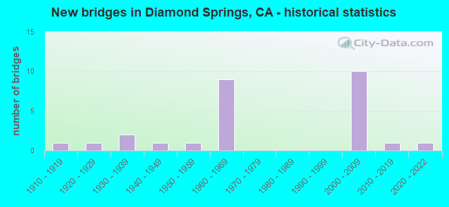
- New bridges - historical statistics
- 11910-1919
- 11920-1929
- 21930-1939
- 11940-1949
- 11950-1959
- 91960-1969
- 102000-2009
- 12010-2019
- 12020-2022

- Reconstructed bridges - Historical Statistics
- 11960-1969
- 01970-1979
- 01980-1989
- 01990-1999
- 22000-2009


- Bridge Condition - Deck
- 77.8%Good
- 22.2%Fair

- Bridge Condition - Superstructure
- 83.3%Good
- 11.1%Fair
- 5.6%Poor

- Bridge Condition - Substructure
- 83.3%Good
- 11.1%Fair
- 5.6%Poor

- Bridge Condition - Channel
- 27.3%Very good
- 9.1%Good
- 54.5%Satisfactory
- 9.1%Poor
Find on map >> Show street view
Structure Number: 25 0005L, Location: 03-ED-050-15.42 (Lat: 38.715975, Lng: -120.836856), Route carried "on" structure: US 50, Year Built: 1963, Year Reconstructed: 2012, Status: Open, Structure Length: 16.78m (55.05ft), Average Daily Traffic: 20,000 (year 2012), Truck Traffic: 6%, Average Future Daily Traffic: 39,000 (year 2037), Design Load: HS 20+Mod, Features Intersected: WEBER CREEK
Minimum Vertical Clearance: 30+ m (98+ ft), Kilometerpoint: 15.420, Lanes on structure: 2, Base Highway Network: Yes (, Subroute: 1), Owner: State Highway Agency, Approaching Roadway Width: 15.2m (49.9ft), Material/Design: Steel, Design/Construction: Stringer/Multi-beam, Number Of Spans In Main Unit: 4, Length of Maximum Span: 41.8m (137.1ft), Curb-To-Curb Width: 15.2m (49.9ft), Out-to-Out Width: 16.1m (52.8ft)
Condition: Deck: Fair, Superstructure: Good, Substructure: Good, Channel: Very good, Operating Rating: 43.1 metric tons, Method Used To Determine Operating Rating: Load and Resistance Factor Rating (LRFR) rating reported by rating factor(RF) method using HL-93 loadings, Inventory Rating: 33.0 metric tons, Method Used To Determine Inventory Rating: Load and Resistance Factor Rating (LRFR) rating reported by rating factor(RF) method using HL-93 loadings, Structural Evaluation: Better than present minimum criteria, Deck Geometry: Superior to present desirable criteria, Waterway Adequacy: Equal to present desirable criteria, Approach Roadway Alignment: Equal to present desirable criteria, Designated Inspection Frequency: Every 24 months, Other Special Inspection Frequency: Every 48 months, Inspection Date: September 2020, Other Special Inspection Date: July 2019, Deck Structure Type: Concrete Cast-file-Place, Wearing Surface/Protective System: Wearing Surface: Integral Concrete
Find on map >> Show street view
Structure Number: 25 0005R, Location: 03-ED-050-15.42 (Lat: 38.715994, Lng: -120.836697), Route carried "on" structure: US 50, Year Built: 1963, Year Reconstructed: 2012, Status: Open, Structure Length: 16.78m (55.05ft), Average Daily Traffic: 20,000 (year 2012), Truck Traffic: 6%, Average Future Daily Traffic: 39,000 (year 2037), Design Load: HS 20+Mod, Features Intersected: WEBER CREEK
Minimum Vertical Clearance: 30+ m (98+ ft), Kilometerpoint: 15.420, Lanes on structure: 3, Base Highway Network: Yes (, Subroute: 1), Owner: State Highway Agency, Approaching Roadway Width: 15.3m (50.2ft), Material/Design: Steel, Design/Construction: Stringer/Multi-beam, Number Of Spans In Main Unit: 4, Length of Maximum Span: 41.8m (137.1ft), Curb or Sidewalk Widths: Left: 0.0m, Right: 5.0m (16.4ft), Curb-To-Curb Width: 15.3m (50.2ft), Out-to-Out Width: 21.5m (70.5ft)
Condition: Deck: Fair, Superstructure: Good, Substructure: Good, Channel: Very good, Operating Rating: 42.4 metric tons, Method Used To Determine Operating Rating: Load and Resistance Factor Rating (LRFR) rating reported by rating factor(RF) method using HL-93 loadings, Inventory Rating: 32.7 metric tons, Method Used To Determine Inventory Rating: Load and Resistance Factor Rating (LRFR) rating reported by rating factor(RF) method using HL-93 loadings, Structural Evaluation: Better than present minimum criteria, Deck Geometry: Meets minimum limits, Waterway Adequacy: Equal to present desirable criteria, Approach Roadway Alignment: Equal to present desirable criteria, Designated Inspection Frequency: Every 24 months, Other Special Inspection Frequency: Every 48 months, Inspection Date: September 2020, Other Special Inspection Date: July 2019, Deck Structure Type: Concrete Cast-file-Place, Wearing Surface/Protective System: Wearing Surface: Integral Concrete
Find on map >> Show street view
Structure Number: 25 0031, Location: 03-ED-049-12.81 (Lat: 38.708111, Lng: -120.812025), Route carried "on" structure: State highway 49, Year Built: 1967, Status: Open, Structure Length: 2.83m (9.28ft), Average Daily Traffic: 9,600 (year 2009), Truck Traffic: 10%, Average Future Daily Traffic: 16,000 (year 2037), Design Load: H 20, Features Intersected: WEBER CREEK
Minimum Vertical Clearance: 30+ m (98+ ft), Kilometerpoint: 12.810, Lanes on structure: 2, Base Highway Network: Yes (, Subroute: 1), Owner: State Highway Agency, Approaching Roadway Width: 9.1m (29.9ft), Material/Design: Concrete, Design/Construction: Box Beam or Girders - Multiple, Number Of Spans In Main Unit: 1, Length of Maximum Span: 27.7m (90.9ft), Curb-To-Curb Width: 9.8m (32.2ft), Out-to-Out Width: 10.4m (34.1ft)
Condition: Deck: Good, Superstructure: Good, Substructure: Good, Channel: Very good, Operating Rating: 43.4 metric tons, Method Used To Determine Operating Rating: Load and Resistance Factor Rating (LRFR) rating reported by rating factor(RF) method using HL-93 loadings, Inventory Rating: 33.4 metric tons, Method Used To Determine Inventory Rating: Load and Resistance Factor Rating (LRFR) rating reported by rating factor(RF) method using HL-93 loadings, Structural Evaluation: Better than present minimum criteria, Deck Geometry: Meets minimum limits, Waterway Adequacy: Equal to present minimum criteria, Approach Roadway Alignment: Equal to present minimum criteria, Designated Inspection Frequency: Every 48 months, Inspection Date: September 2018, Deck Structure Type: Concrete Cast-file-Place, Wearing Surface/Protective System: Wearing Surface: Bituminous, Membrane: Preformed Fabric
Find on map >> Show street view
Structure Number: 25 0075L, Location: 03-ED-050-R12.19 (Lat: 38.695983, Lng: -120.887983), Route carried "on" structure: US 50, Year Built: 1969, Status: Open, Structure Length: 2.71m (8.89ft), Average Daily Traffic: 23,000 (year 2009), Average Future Daily Traffic: 48,000 (year 2037), Design Load: HS 20+Mod, Features Intersected: GREENSTONE ROAD
Minimum Vertical Clearance: 30+ m (98+ ft), Kilometerpoint: 12.190, Lanes on structure: 2, Lanes under structure: 2, Base Highway Network: Yes (, Subroute: 1), Owner: State Highway Agency, Approaching Roadway Width: 11.9m (39.0ft), Skew: 1 degrees, Material/Design: Concrete, Design/Construction: Box Beam or Girders - Multiple, Number Of Spans In Main Unit: 1, Length of Maximum Span: 26.8m (87.9ft), Curb-To-Curb Width: 11.9m (39.0ft), Out-to-Out Width: 12.5m (41.0ft)
Condition: Deck: Fair, Superstructure: Good, Substructure: Good, Operating Rating: 38.6 metric tons, Method Used To Determine Operating Rating: Load and Resistance Factor Rating (LRFR) rating reported by rating factor(RF) method using HL-93 loadings, Inventory Rating: 29.8 metric tons, Method Used To Determine Inventory Rating: Load and Resistance Factor Rating (LRFR) rating reported by rating factor(RF) method using HL-93 loadings, Structural Evaluation: Better than present minimum criteria, Deck Geometry: Better than present minimum criteria, Underclear: High priority of corrective action, Approach Roadway Alignment: Equal to present desirable criteria, Designated Inspection Frequency: Every 24 months, Inspection Date: September 2020, Deck Structure Type: Concrete Cast-file-Place
Find on map >> Show street view
Structure Number: 25 0075R, Location: 03-ED-050-R12.19 (Lat: 38.695711, Lng: -120.887900), Route carried "on" structure: US 50, Year Built: 1969, Status: Open, Structure Length: 2.71m (8.89ft), Average Daily Traffic: 23,000 (year 2009), Average Future Daily Traffic: 48,000 (year 2037), Design Load: HS 20+Mod, Features Intersected: GREENSTONE ROAD
Minimum Vertical Clearance: 30+ m (98+ ft), Kilometerpoint: 12.190, Lanes on structure: 2, Lanes under structure: 3, Base Highway Network: Yes (, Subroute: 1), Owner: State Highway Agency, Approaching Roadway Width: 11.9m (39.0ft), Skew: 1 degrees, Material/Design: Concrete, Design/Construction: Box Beam or Girders - Multiple, Number Of Spans In Main Unit: 1, Length of Maximum Span: 26.8m (87.9ft), Curb-To-Curb Width: 11.9m (39.0ft), Out-to-Out Width: 12.5m (41.0ft)
Condition: Deck: Fair, Superstructure: Good, Substructure: Good, Operating Rating: 38.6 metric tons, Method Used To Determine Operating Rating: Load and Resistance Factor Rating (LRFR) rating reported by rating factor(RF) method using HL-93 loadings, Inventory Rating: 29.8 metric tons, Method Used To Determine Inventory Rating: Load and Resistance Factor Rating (LRFR) rating reported by rating factor(RF) method using HL-93 loadings, Structural Evaluation: Better than present minimum criteria, Deck Geometry: Better than present minimum criteria, Underclear: High priority of corrective action, Approach Roadway Alignment: Equal to present desirable criteria, Designated Inspection Frequency: Every 24 months, Inspection Date: September 2020, Deck Structure Type: Concrete Cast-file-Place
Find on map >> Show street view
Structure Number: 25 0076, Location: 03-ED-050-R14.01 (Lat: 38.705056, Lng: -120.856647), Route carried "on" structure: County highway , Year Built: 1969, Status: Open, Structure Length: 6.33m (20.77ft), Average Daily Traffic: 5,000 (year 2012), Truck Traffic: 6%, Average Future Daily Traffic: 6,200 (year 2037), Design Load: HS 20+Mod, Features Intersected: US HIGHWAY 50, Facility Carried by Structure: EL DORADO ROAD
Minimum Vertical Clearance: 30+ m (98+ ft), Kilometerpoint: 0.000, Lanes on structure: 2, Lanes under structure: 4, Owner: State Highway Agency, Approaching Roadway Width: 7.9m (25.9ft), Material/Design: Concrete continuous, Design/Construction: Box Beam or Girders - Multiple, Number Of Spans In Main Unit: 2, Length of Maximum Span: 32.3m (106.0ft), Curb or Sidewalk Widths: Left: 0.0m, Right: 1.5m (4.9ft), Curb-To-Curb Width: 9.1m (29.9ft), Out-to-Out Width: 11.3m (37.1ft)
Condition: Deck: Good, Superstructure: Good, Substructure: Good, Operating Rating: 37.3 metric tons, Method Used To Determine Operating Rating: Load and Resistance Factor Rating (LRFR) rating reported by rating factor(RF) method using HL-93 loadings, Inventory Rating: 28.5 metric tons, Method Used To Determine Inventory Rating: Load and Resistance Factor Rating (LRFR) rating reported by rating factor(RF) method using HL-93 loadings, Structural Evaluation: Better than present minimum criteria, Deck Geometry: Meets minimum limits, Underclear: Meets minimum limits, Approach Roadway Alignment: Equal to present desirable criteria, Designated Inspection Frequency: Every 24 months, Inspection Date: September 2020, Deck Structure Type: Concrete Cast-file-Place, Wearing Surface/Protective System: Wearing Surface: Integral Concrete
Find on map >> Show street view
Structure Number: 25 0119S, Location: 03-ED-050-R11.20 (Lat: 38.689703, Lng: -120.904653), Route carried "on" structure: Ramp US 50, Year Built: 2009, Status: Open, Structure Length: 23.70m (77.76ft), Average Daily Traffic: 10,000 (year 2012), Truck Traffic: 1%, Average Future Daily Traffic: 16,000 (year 2037), Design Load: HS 20+Mod, Features Intersected: US HIGHWAY 50 & RAMPS, Facility Carried by Structure: RED HAWK PKWY RAMP
Minimum Vertical Clearance: 30+ m (98+ ft), Kilometerpoint: 11.200, Lanes on structure: 1, Lanes under structure: 6, Owner: State Highway Agency, Approaching Roadway Width: 9.0m (29.5ft), Material/Design: Prestressed concrete continuous, Design/Construction: Box Beam or Girders - Multiple, Number Of Spans In Main Unit: 4, Length of Maximum Span: 64.4m (211.3ft), Curb-To-Curb Width: 9.0m (29.5ft), Out-to-Out Width: 9.9m (32.5ft)
Condition: Deck: Good, Superstructure: Good, Substructure: Good, Operating Rating: 54.1 metric tons, Method Used To Determine Operating Rating: Assigned rating based on Load Factor Design (LFD) reported in metric tons, Inventory Rating: 32.4 metric tons, Method Used To Determine Inventory Rating: Assigned rating based on Load Factor Design (LFD) reported in metric tons, Structural Evaluation: Better than present minimum criteria, Deck Geometry: Superior to present desirable criteria, Underclear: Meets minimum limits, Approach Roadway Alignment: Equal to present desirable criteria, Designated Inspection Frequency: Every 24 months, Inspection Date: September 2020, Deck Structure Type: Concrete Cast-file-Place
Find on map >> Show street view
Structure Number: 25 0120L, Location: 03-ED-050-R11.25 (Lat: 38.690467, Lng: -120.904114), Route carried "on" structure: US 50, Year Built: 2009, Status: Open, Structure Length: 4.03m (13.22ft), Average Daily Traffic: 23,000 (year 2012), Average Future Daily Traffic: 45,000 (year 2037), Design Load: HS 20+Mod, Features Intersected: RED HAWK PKWY-E50 ONRAMP
Minimum Vertical Clearance: 30+ m (98+ ft), Kilometerpoint: 11.250, Lanes on structure: 2, Lanes under structure: 1, Base Highway Network: Yes (, Subroute: 1), Owner: State Highway Agency, Approaching Roadway Width: 16.8m (55.1ft), Skew: 3 degrees, Material/Design: Prestressed concrete, Design/Construction: Box Beam or Girders - Multiple, Number Of Spans In Main Unit: 1, Length of Maximum Span: 38.1m (125.0ft), Curb-To-Curb Width: 16.8m (55.1ft), Out-to-Out Width: 17.7m (58.1ft)
Condition: Deck: Good, Superstructure: Good, Substructure: Good, Operating Rating: 54.1 metric tons, Method Used To Determine Operating Rating: Assigned rating based on Load Factor Design (LFD) reported in metric tons, Inventory Rating: 32.4 metric tons, Method Used To Determine Inventory Rating: Assigned rating based on Load Factor Design (LFD) reported in metric tons, Structural Evaluation: Better than present minimum criteria, Deck Geometry: Superior to present desirable criteria, Underclear: Equal to present minimum criteria, Approach Roadway Alignment: Equal to present desirable criteria, Designated Inspection Frequency: Every 24 months, Inspection Date: September 2020, Deck Structure Type: Concrete Cast-file-Place, Wearing Surface/Protective System: Wearing Surface: Integral Concrete
Find on map >> Show street view
Structure Number: 25 0120R, Location: 03-ED-050-R11.25 (Lat: 38.690383, Lng: -120.903792), Route carried "on" structure: US 50, Year Built: 2009, Status: Open, Structure Length: 4.11m (13.48ft), Average Daily Traffic: 23,000 (year 2012), Average Future Daily Traffic: 45,000 (year 2037), Design Load: HS 20+Mod, Features Intersected: RED HAWK PKWY-E50 ONRAMP
Minimum Vertical Clearance: 30+ m (98+ ft), Kilometerpoint: 11.250, Lanes on structure: 2, Lanes under structure: 1, Base Highway Network: Yes (, Subroute: 1), Owner: State Highway Agency, Approaching Roadway Width: 16.8m (55.1ft), Skew: 3 degrees, Material/Design: Prestressed concrete, Design/Construction: Box Beam or Girders - Multiple, Number Of Spans In Main Unit: 1, Length of Maximum Span: 39.0m (128.0ft), Curb-To-Curb Width: 16.8m (55.1ft), Out-to-Out Width: 17.7m (58.1ft)
Condition: Deck: Good, Superstructure: Good, Substructure: Good, Operating Rating: 54.1 metric tons, Method Used To Determine Operating Rating: Assigned rating based on Load Factor Design (LFD) reported in metric tons, Inventory Rating: 32.4 metric tons, Method Used To Determine Inventory Rating: Assigned rating based on Load Factor Design (LFD) reported in metric tons, Structural Evaluation: Better than present minimum criteria, Deck Geometry: Superior to present desirable criteria, Underclear: Equal to present minimum criteria, Approach Roadway Alignment: Equal to present desirable criteria, Designated Inspection Frequency: Every 24 months, Inspection Date: September 2020, Deck Structure Type: Concrete Cast-file-Place, Wearing Surface/Protective System: Wearing Surface: Integral Concrete
Find on map >> Show street view
Structure Number: 25 0121, Location: 03-ED-050-R15.06 (Lat: 38.711436, Lng: -120.839667), Route carried "on" structure: City street , Year Built: 2008, Status: Open, Structure Length: 5.59m (18.34ft), Average Daily Traffic: 60,000 (year 2008), Truck Traffic: 10%, Average Future Daily Traffic: 83,000 (year 2037), Design Load: HS 20+Mod, Features Intersected: US HIGHWAY 50, Facility Carried by Structure: MISSOURI FLAT ROAD
Minimum Vertical Clearance: 30+ m (98+ ft), Kilometerpoint: 0.000, Lanes on structure: 6, Lanes under structure: 4, Base Highway Network: Yes, Owner: State Highway Agency, Approaching Roadway Width: 28.8m (94.5ft), Material/Design: Concrete continuous, Design/Construction: Box Beam or Girders - Multiple, Number Of Spans In Main Unit: 2, Length of Maximum Span: 28.6m (93.8ft), Curb or Sidewalk Widths: Left: 1.5m (4.9ft), Right: 1.5m (4.9ft), Curb-To-Curb Width: 28.8m (94.5ft), Out-to-Out Width: 32.5m (106.6ft)
Condition: Deck: Good, Superstructure: Good, Substructure: Good, Operating Rating: 54.1 metric tons, Method Used To Determine Operating Rating: Assigned rating based on Load Factor Design (LFD) reported in metric tons, Inventory Rating: 32.4 metric tons, Method Used To Determine Inventory Rating: Assigned rating based on Load Factor Design (LFD) reported in metric tons, Structural Evaluation: Better than present minimum criteria, Deck Geometry: Superior to present desirable criteria, Underclear: Equal to present minimum criteria, Approach Roadway Alignment: Equal to present desirable criteria, Designated Inspection Frequency: Every 48 months, Inspection Date: September 2018, Deck Structure Type: Concrete Cast-file-Place
Find on map >> Show street view
Structure Number: 25C0041, Location: 0.8 MI W MISSOURI FLAT R (Lat: 38.720092, Lng: -120.881078), Route carried "on" structure: County highway , Year Built: 1935, Status: Open, Structure Length: 0.91m (2.99ft), Average Daily Traffic: 4,351 (year 2012), Truck Traffic: 10%, Average Future Daily Traffic: 5,379 (year 2040), Features Intersected: MOUND SPRINGS CREEK, Facility Carried by Structure: GREEN VALLEY ROAD
Minimum Vertical Clearance: 30+ m (98+ ft), Kilometerpoint: 0.000, Lanes on structure: 2, Owner: County Highway Agency, Approaching Roadway Width: 7.3m (24.0ft), Skew: 4 degrees, Material/Design: Concrete continuous, Design/Construction: Box Beam or Girders - Multiple, Number Of Spans In Main Unit: 2, Length of Maximum Span: 4.6m (15.1ft), Curb or Sidewalk Widths: Left: 0.2m (0.7ft), Right: 0.2m (0.7ft), Curb-To-Curb Width: 6.1m (20.0ft), Out-to-Out Width: 6.8m (22.3ft)
Condition: Deck: Good, Superstructure: Poor, Substructure: Good, Channel: Satisfactory, Operating Rating: 26.9 metric tons, Method Used To Determine Operating Rating: Field evaluation and documented engineering judgment, Inventory Rating: 16.2 metric tons, Method Used To Determine Inventory Rating: Field evaluation and documented engineering judgment, Structural Evaluation: Meets minimum limits, Deck Geometry: High priority of replacement, Waterway Adequacy: Better than present minimum criteria, Approach Roadway Alignment: Equal to present minimum criteria, Length Of Structure Improvement: 0.91m (2.99ft), Designated Inspection Frequency: Every 24 months, Inspection Date: July 2020, Bridge Improvement Cost: $142,000, Deck Structure Type: Concrete Cast-file-Place, Wearing Surface/Protective System: Wearing Surface: Bituminous
Find on map >> Show street view
Structure Number: 25C0053, Location: 0.4 MI S PLEASANT VALY RD (Lat: 38.670231, Lng: -120.753689), Route carried "on" structure: County highway , Year Built: 1930, Status: Open, Structure Length: 0.70m (2.30ft), Average Daily Traffic: 1,245 (year 2010), Truck Traffic: 10%, Average Future Daily Traffic: 2,180 (year 2042), Features Intersected: SQUAW HOLLOW CREEK, Facility Carried by Structure: HANKS EXCHANGE RD
Minimum Vertical Clearance: 30+ m (98+ ft), Kilometerpoint: 0.000, Lanes on structure: 1, Owner: County Highway Agency, Approaching Roadway Width: 5.5m (18.0ft), Material/Design: Concrete, Design/Construction: Stringer/Multi-beam, Number Of Spans In Main Unit: 1, Length of Maximum Span: 6.6m (21.7ft), Curb or Sidewalk Widths: Left: 0.2m (0.7ft), Right: 0.2m (0.7ft), Curb-To-Curb Width: 4.1m (13.5ft), Out-to-Out Width: 4.9m (16.1ft)
Condition: Deck: Good, Superstructure: Fair, Substructure: Poor, Channel: Poor, Operating Rating: 28.5 metric tons, Method Used To Determine Operating Rating: Field evaluation and documented engineering judgment, Inventory Rating: 17.2 metric tons, Method Used To Determine Inventory Rating: Field evaluation and documented engineering judgment, Structural Evaluation: Meets minimum limits, Deck Geometry: High priority of replacement, Waterway Adequacy: Better than present minimum criteria, Approach Roadway Alignment: High priority of corrective action, Length Of Structure Improvement: 0.70m (2.30ft), Designated Inspection Frequency: Every 24 months, Inspection Date: June 2020, Bridge Improvement Cost: $75,000, Roadway Improvement Cost: $15,000, Total Project Cost: $127,000 ( Estimate for 2017), Deck Structure Type: Concrete Cast-file-Place, Wearing Surface/Protective System: Wearing Surface: Bituminous
Find on map >> Show street view
Structure Number: 25C0075, Location: AT QUARRY RD (Lat: 38.694228, Lng: -120.784794), Route carried "on" structure: County highway , Year Built: 1950, Year Reconstructed: 1960, Status: Open, Structure Length: 0.67m (2.20ft), Average Daily Traffic: 857 (year 2012), Truck Traffic: 10%, Average Future Daily Traffic: 2,652 (year 2042), Features Intersected: RINGOLD CREEK, Facility Carried by Structure: BIG CUT RD
Minimum Vertical Clearance: 30+ m (98+ ft), Kilometerpoint: 0.000, Lanes on structure: 2, Owner: County Highway Agency, Approaching Roadway Width: 7.3m (24.0ft), Skew: 2 degrees, Material/Design: Concrete, Design/Construction: Slab, Number Of Spans In Main Unit: 1, Length of Maximum Span: 6.3m (20.7ft), Curb or Sidewalk Widths: Left: 0.2m (0.7ft), Right: 0.2m (0.7ft), Curb-To-Curb Width: 8.4m (27.6ft), Out-to-Out Width: 9.1m (29.9ft)
Condition: Deck: Good, Superstructure: Good, Substructure: Good, Channel: Satisfactory, Operating Rating: 40.5 metric tons, Method Used To Determine Operating Rating: Field evaluation and documented engineering judgment, Inventory Rating: 24.3 metric tons, Method Used To Determine Inventory Rating: Field evaluation and documented engineering judgment, Structural Evaluation: Equal to present minimum criteria, Deck Geometry: Somewhat better than minimum adequacy, Waterway Adequacy: Better than present minimum criteria, Approach Roadway Alignment: Equal to present minimum criteria, Designated Inspection Frequency: Every 24 months, Inspection Date: June 2020, Deck Structure Type: Concrete Cast-file-Place, Wearing Surface/Protective System: Wearing Surface: Bituminous
Find on map >> Show street view
Structure Number: 25C0076, Location: 1.2 MI N/O PLEASANT V RD (Lat: 38.703594, Lng: -120.792344), Route carried "on" structure: County highway , Year Built: 1922, Status: Open, Structure Length: 1.46m (4.79ft), Average Daily Traffic: 857 (year 2012), Truck Traffic: 10%, Average Future Daily Traffic: 3,094 (year 2042), Features Intersected: WEBER CREEK, Facility Carried by Structure: BIG CUT RD
Minimum Vertical Clearance: 30+ m (98+ ft), Kilometerpoint: 0.000, Lanes on structure: 1, Owner: County Highway Agency, Approaching Roadway Width: 5.5m (18.0ft), Material/Design: Concrete continuous, Design/Construction: Tee Beam, Number Of Spans In Main Unit: 2, Length of Maximum Span: 7.1m (23.3ft), Curb-To-Curb Width: 5.0m (16.4ft), Out-to-Out Width: 5.2m (17.1ft)
Condition: Deck: Good, Superstructure: Good, Substructure: Fair, Channel: Satisfactory, Operating Rating: 99.8 metric tons, Method Used To Determine Operating Rating: Load Factor (LF), Inventory Rating: 96.6 metric tons, Method Used To Determine Inventory Rating: Load Factor (LF), Structural Evaluation: Somewhat better than minimum adequacy, Deck Geometry: High priority of replacement, Waterway Adequacy: Better than present minimum criteria, Approach Roadway Alignment: Equal to present minimum criteria, Designated Inspection Frequency: Every 24 months, Inspection Date: June 2020, Deck Structure Type: Concrete Cast-file-Place, Wearing Surface/Protective System: Wearing Surface: Integral Concrete
Find on map >> Show street view
Structure Number: 25C0096, Location: 0.6 MI S PLEASANT VALY RD (Lat: 38.670594, Lng: -120.776442), Route carried "on" structure: County highway , Year Built: 1945, Status: Open, Structure Length: 0.73m (2.40ft), Average Daily Traffic: 1,985 (year 2012), Truck Traffic: 10%, Average Future Daily Traffic: 1,704 (year 2040), Features Intersected: SQUAW HOLLOW CREEK, Facility Carried by Structure: OAK HILL ROAD
Minimum Vertical Clearance: 30+ m (98+ ft), Kilometerpoint: 0.000, Lanes on structure: 1, Owner: County Highway Agency, Approaching Roadway Width: 5.5m (18.0ft), Material/Design: Concrete, Design/Construction: Tee Beam, Number Of Spans In Main Unit: 1, Length of Maximum Span: 6.7m (22.0ft), Curb-To-Curb Width: 6.0m (19.7ft), Out-to-Out Width: 6.7m (22.0ft)
Condition: Deck: Good, Superstructure: Good, Substructure: Good, Channel: Satisfactory, Operating Rating: 28.8 metric tons, Method Used To Determine Operating Rating: Field evaluation and documented engineering judgment, Inventory Rating: 17.2 metric tons, Method Used To Determine Inventory Rating: Field evaluation and documented engineering judgment, Structural Evaluation: Meets minimum limits, Deck Geometry: High priority of replacement, Waterway Adequacy: Better than present minimum criteria, Approach Roadway Alignment: Equal to present minimum criteria, Designated Inspection Frequency: Every 24 months, Inspection Date: June 2020, Deck Structure Type: Concrete Cast-file-Place, Wearing Surface/Protective System: Wearing Surface: Bituminous
Find on map >> Show street view
Structure Number: 25C0116, Location: 1.1 MI N/E MISSOURI FLAT (Lat: 38.713711, Lng: -120.828069), Route carried "on" structure: County highway , Year Built: 1914, Status: Open, Structure Length: 3.57m (11.71ft), Average Daily Traffic: 2,049 (year 2012), Truck Traffic: 10%, Average Future Daily Traffic: 7,101 (year 2040), Features Intersected: WEBER CREEK, Facility Carried by Structure: FORNI ROAD
Minimum Vertical Clearance: 30+ m (98+ ft), Kilometerpoint: 0.000, Lanes on structure: 2, Owner: County Highway Agency, Approaching Roadway Width: 6.1m (20.0ft), Material/Design: Concrete continuous, Design/Construction: Arch - Deck, Number Of Spans In Main Unit: 1, Number Of Approach Spans: 2, Length of Maximum Span: 24.4m (80.1ft), Curb or Sidewalk Widths: Left: 0.2m (0.7ft), Right: 0.2m (0.7ft), Curb-To-Curb Width: 6.2m (20.3ft), Out-to-Out Width: 7.2m (23.6ft)
Condition: Deck: Good, Superstructure: Good, Substructure: Fair, Channel: Satisfactory, Operating Rating: 27.2 metric tons, Method Used To Determine Operating Rating: Field evaluation and documented engineering judgment, Inventory Rating: 16.2 metric tons, Method Used To Determine Inventory Rating: Field evaluation and documented engineering judgment, Structural Evaluation: Meets minimum limits, Deck Geometry: High priority of replacement, Waterway Adequacy: Equal to present desirable criteria, Approach Roadway Alignment: Somewhat better than minimum adequacy, Designated Inspection Frequency: Every 24 months, Inspection Date: July 2020, Deck Structure Type: Concrete Cast-file-Place, Wearing Surface/Protective System: Wearing Surface: Bituminous
Find on map >> Show street view
Structure Number: 25C0136, Location: 0.6 MI N OF MOTHERLODE DR (Lat: 38.681817, Lng: -120.887819), Route carried "on" structure: County highway , Year Built: 2020, Status: Open, Structure Length: 1.16m (3.81ft), Average Daily Traffic: 1,284 (year 2012), Truck Traffic: 5%, Average Future Daily Traffic: 3,013 (year 2040), Design Load: HL 93, Features Intersected: SLATE CREEK, Facility Carried by Structure: GREENSTONE ROAD
Minimum Vertical Clearance: 30+ m (98+ ft), Kilometerpoint: 0.000, Lanes on structure: 2, Owner: County Highway Agency, Approaching Roadway Width: 9.1m (29.9ft), Material/Design: Concrete, Design/Construction: Slab, Number Of Spans In Main Unit: 1, Length of Maximum Span: 10.4m (34.1ft), Curb-To-Curb Width: 9.1m (29.9ft), Out-to-Out Width: 10.2m (33.5ft)
Condition: Deck: Good, Superstructure: Good, Substructure: Good, Channel: Satisfactory, Operating Rating: 54.1 metric tons, Method Used To Determine Operating Rating: Field evaluation and documented engineering judgment, Inventory Rating: 32.4 metric tons, Method Used To Determine Inventory Rating: Field evaluation and documented engineering judgment, Structural Evaluation: Better than present minimum criteria, Deck Geometry: Somewhat better than minimum adequacy, Waterway Adequacy: Equal to present desirable criteria, Approach Roadway Alignment: Equal to present desirable criteria, Designated Inspection Frequency: Every 24 months, Inspection Date: October 2020, Deck Structure Type: Concrete Cast-file-Place
Find on map >> Show street view
Structure Number: 25C0141, Location: 0.7 MI W PLACERVILLE DR (Lat: 38.722389, Lng: -120.845583), Route carried "on" structure: County highway , Year Built: 2016, Status: Open, Structure Length: 5.03m (16.50ft), Average Daily Traffic: 5,500 (year 2017), Truck Traffic: 4%, Average Future Daily Traffic: 8,161 (year 2040), Design Load: HL 93, Features Intersected: WEBER CREEK, Facility Carried by Structure: GREEN VALLEY ROAD
Minimum Vertical Clearance: 30+ m (98+ ft), Kilometerpoint: 0.000, Lanes on structure: 2, Base Highway Network: Yes, Owner: County Highway Agency, Approaching Roadway Width: 12.2m (40.0ft), Skew: 9 degrees, Material/Design: Prestressed concrete, Design/Construction: Box Beam or Girders - Multiple, Number Of Spans In Main Unit: 1, Length of Maximum Span: 49.5m (162.4ft), Curb-To-Curb Width: 12.2m (40.0ft), Out-to-Out Width: 13.1m (43.0ft)
Condition: Deck: Good, Superstructure: Fair, Substructure: Good, Channel: Good, Operating Rating: 42.1 metric tons, Method Used To Determine Operating Rating: Assigned ratings based on Load and Resistance Factor Design (LRFD) reported by rating factor (RF) using HL93 loadings, Inventory Rating: 32.4 metric tons, Method Used To Determine Inventory Rating: Assigned ratings based on Load and Resistance Factor Design (LRFD) reported by rating factor (RF) using HL93 loadings, Structural Evaluation: Somewhat better than minimum adequacy, Deck Geometry: Somewhat better than minimum adequacy, Waterway Adequacy: Better than present minimum criteria, Approach Roadway Alignment: Equal to present desirable criteria, Designated Inspection Frequency: Every 24 months, Inspection Date: July 2020, Deck Structure Type: Concrete Cast-file-Place
Find on map >> Show street view
Structure Number: 25 0075L, Location: 03-ED-050-R12.19 (Lat: 38.695983, Lng: -120.887983), Route carried "under" structure: County highway , Year Built: 1969, Structure Length: 0. m, Average Daily Traffic: 2,500 (year 2010), Truck Traffic: 5%, Features Intersected: GREENSTONE ROAD, Facility Carried by Structure: U.S. HIGHWAY 50 WB
Minimum Vertical Clearance: 5.23m (17.16ft), Kilometerpoint: 0.000, Lanes on structure: 2, Lanes under structure: 2, Material/Design: Concrete, Design/Construction: Box Beam or Girders - Multiple, Length of Maximum Span: 26.8m (87.9ft)
Find on map >> Show street view
Structure Number: 25 0075R, Location: 03-ED-050-R12.19 (Lat: 38.695711, Lng: -120.887900), Route carried "under" structure: County highway , Year Built: 1969, Structure Length: 0. m, Average Daily Traffic: 2,500 (year 2010), Truck Traffic: 12%, Features Intersected: GREENSTONE ROAD, Facility Carried by Structure: U.S. HIGHWAY 50 EB
Minimum Vertical Clearance: 4.70m (15.42ft), Kilometerpoint: 0.000, Lanes on structure: 2, Lanes under structure: 3, Material/Design: Concrete, Design/Construction: Box Beam or Girders - Multiple, Length of Maximum Span: 26.8m (87.9ft)
Find on map >> Show street view
Structure Number: 25 0076, Location: 03-ED-050-R14.01 (Lat: 38.705056, Lng: -120.856647), Route carried "under" structure: US 50, Year Built: 1969, Structure Length: 0. m, Average Daily Traffic: 46,000 (year 2012), Truck Traffic: 6%, Features Intersected: US HIGHWAY 50, Facility Carried by Structure: EL DORADO ROAD
Minimum Vertical Clearance: 4.95m (16.24ft), Kilometerpoint: 14.010, Lanes on structure: 2, Lanes under structure: 4, Material/Design: Concrete continuous, Design/Construction: Box Beam or Girders - Multiple, Length of Maximum Span: 32.3m (106.0ft)
Find on map >> Show street view
Structure Number: 25 0119S, Location: 03-ED-050-R11.20 (Lat: 38.689703, Lng: -120.904653), Route carried "under" structure: Ramp US 50, Year Built: 2009, Structure Length: 0. m, Average Daily Traffic: 10,000 (year 2012), Truck Traffic: 2%, Features Intersected: US HIGHWAY 50 & RAMPS, Facility Carried by Structure: RED HAWK PKWY RAMP
Minimum Vertical Clearance: 6.70m (21.98ft), Kilometerpoint: 11.200, Lanes on structure: 1, Lanes under structure: 1, Material/Design: Prestressed concrete continuous, Design/Construction: Box Beam or Girders - Multiple, Length of Maximum Span: 64.4m (211.3ft)
Find on map >> Show street view
Structure Number: 25 0119S, Location: 03-ED-050-R11.20 (Lat: 38.689703, Lng: -120.904653), Route carried "under" structure: US 50, Year Built: 2009, Structure Length: 0. m, Average Daily Traffic: 56,000 (year 2012), Truck Traffic: 6%, Features Intersected: US HIGHWAY 50 & RAMPS, Facility Carried by Structure: RED HAWK PKWY RAMP
Minimum Vertical Clearance: 6.30m (20.67ft), Kilometerpoint: 11.200, Lanes on structure: 1, Lanes under structure: 4, Material/Design: Prestressed concrete continuous, Design/Construction: Box Beam or Girders - Multiple, Length of Maximum Span: 64.4m (211.3ft)
Find on map >> Show street view
Structure Number: 25 0119S, Location: 03-ED-050-R11.20 (Lat: 38.689703, Lng: -120.904653), Route carried "under" structure: Ramp US 50, Year Built: 2009, Structure Length: 0. m, Average Daily Traffic: 10,000 (year 2012), Truck Traffic: 2%, Features Intersected: US HIGHWAY 50 & RAMPS, Facility Carried by Structure: RED HAWK PKWY RAMP
Minimum Vertical Clearance: 12.12m (39.76ft), Kilometerpoint: 11.200, Lanes on structure: 1, Lanes under structure: 1, Material/Design: Prestressed concrete continuous, Design/Construction: Box Beam or Girders - Multiple, Length of Maximum Span: 64.4m (211.3ft)
Find on map >> Show street view
Structure Number: 25 0120L, Location: 03-ED-050-R11.25 (Lat: 38.690467, Lng: -120.904114), Route carried "under" structure: Ramp US 50, Year Built: 2009, Structure Length: 0. m, Average Daily Traffic: 5,000 (year 2012), Truck Traffic: 2%, Features Intersected: RED HAWK PKWY-E50 ONRAMP
Minimum Vertical Clearance: 5.33m (17.49ft), Kilometerpoint: 11.250, Lanes on structure: 2, Lanes under structure: 1, Material/Design: Prestressed concrete, Design/Construction: Box Beam or Girders - Multiple, Length of Maximum Span: 38.1m (125.0ft)
Find on map >> Show street view
Structure Number: 25 0120R, Location: 03-ED-050-R11.25 (Lat: 38.690383, Lng: -120.903792), Route carried "under" structure: Ramp US 50, Year Built: 2009, Structure Length: 0. m, Average Daily Traffic: 5,000 (year 2012), Truck Traffic: 2%, Features Intersected: RED HAWK PKWY-E50 ONRAMP
Minimum Vertical Clearance: 5.35m (17.55ft), Kilometerpoint: 11.250, Lanes on structure: 2, Lanes under structure: 1, Material/Design: Prestressed concrete, Design/Construction: Box Beam or Girders - Multiple, Length of Maximum Span: 39.0m (128.0ft)
Find on map >> Show street view
Structure Number: 25 0121, Location: 03-ED-050-R15.06 (Lat: 38.711436, Lng: -120.839667), Route carried "under" structure: US 50, Year Built: 2008, Structure Length: 0. m, Average Daily Traffic: 52,000 (year 2009), Truck Traffic: 6%, Features Intersected: US HIGHWAY 50, Facility Carried by Structure: MISSOURI FLAT ROAD
Minimum Vertical Clearance: 5.40m (17.72ft), Kilometerpoint: 15.060, Lanes on structure: 6, Lanes under structure: 4, Material/Design: Concrete continuous, Design/Construction: Box Beam or Girders - Multiple, Length of Maximum Span: 28.6m (93.8ft)