Bridge Statistics for Corcoran, California (CA)
Condition, Traffic, Stress, Structural Evaluation, Project Costs
- National Bridge Inventory (NBI) Statistics
- 20Number of bridges
- 174ft / 52.5mTotal length
- $480,000Total costs
- 30,606Total average daily traffic
- 4,502Total average daily truck traffic
- 41,925Total future (year 2037) average daily traffic
- National Bridge Inventory (NBI) Registered Bridges for Corcoran
- No street view available for this location
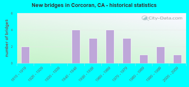
- New bridges - historical statistics
- 21910-1919
- 41940-1949
- 31950-1959
- 41960-1969
- 31970-1979
- 11980-1989
- 21990-1999
- 12000-2009

- Reconstructed bridges - Historical Statistics
- 21940-1949
- 01950-1959
- 11960-1969
- 01970-1979
- 01980-1989
- 11990-1999


- Bridge Condition - Deck
- 62.5%Good
- 31.3%Fair
- 6.3%Poor

- Bridge Condition - Superstructure
- 68.8%Good
- 31.3%Fair

- Bridge Condition - Substructure
- 56.3%Good
- 37.5%Fair
- 6.3%Poor

- Bridge Condition - Channel
- 10.0%Very good
- 30.0%Good
- 45.0%Satisfactory
- 15.0%Fair

- Bridge Condition - Culverts
- 50.0%Good
- 50.0%Satisfactory
Find on map >> Show street view
Structure Number: 45 0024, Location: 06-KIN-137-2.03 (Lat: 36.120436, Lng: -119.536581), Route carried "on" structure: State highway 137, Year Built: 1918, Year Reconstructed: 1952, Status: Open, Structure Length: 1.55m (5.09ft), Average Daily Traffic: 2,050 (year 2009), Truck Traffic: 9%, Average Future Daily Traffic: 2,670 (year 2038), Features Intersected: AX CANAL
Minimum Vertical Clearance: 30+ m (98+ ft), Kilometerpoint: 2.030, Lanes on structure: 2, Base Highway Network: Yes (Inventory Route: 1, Subroute: 1), Owner: State Highway Agency, Approaching Roadway Width: 7.3m (24.0ft), Skew: 4 degrees, Material/Design: Concrete continuous, Design/Construction: Slab, Number Of Spans In Main Unit: 3, Length of Maximum Span: 5.2m (17.1ft), Curb-To-Curb Width: 9.0m (29.5ft), Out-to-Out Width: 9.9m (32.5ft)
Condition: Deck: Good, Superstructure: Good, Substructure: Fair, Channel: Good, Operating Rating: 42.4 metric tons, Method Used To Determine Operating Rating: Load Factor (LF), Inventory Rating: 25.6 metric tons, Method Used To Determine Inventory Rating: Load Factor (LF), Structural Evaluation: Somewhat better than minimum adequacy, Deck Geometry: Meets minimum limits, Waterway Adequacy: Better than present minimum criteria, Approach Roadway Alignment: Equal to present minimum criteria, Designated Inspection Frequency: Every 24 months, Inspection Date: December 2020, Deck Structure Type: Concrete Cast-file-Place, Wearing Surface/Protective System: Wearing Surface: Bituminous
Find on map >> Show street view
Structure Number: 45 0053, Location: 06-KIN-043-7.92 (Lat: 36.175603, Lng: -119.600264), Route carried "on" structure: State highway 43, Year Built: 1953, Year Reconstructed: 1999, Status: Open, Structure Length: 4.97m (16.31ft), Average Daily Traffic: 4,800 (year 2009), Truck Traffic: 28%, Average Future Daily Traffic: 15,321 (year 2042), Design Load: HS 20, Features Intersected: EAST BRANCH CROSS CREEK
Minimum Vertical Clearance: 30+ m (98+ ft), Kilometerpoint: 7.920, Lanes on structure: 2, Base Highway Network: Yes (, Subroute: 1), Owner: State Highway Agency, Approaching Roadway Width: 12.0m (39.4ft), Skew: 2 degrees, Material/Design: Concrete continuous, Design/Construction: Slab, Number Of Spans In Main Unit: 8, Length of Maximum Span: 6.1m (20.0ft), Curb-To-Curb Width: 13.0m (42.7ft), Out-to-Out Width: 13.4m (44.0ft)
Condition: Deck: Good, Superstructure: Good, Substructure: Good, Channel: Satisfactory, Operating Rating: 46.7 metric tons, Method Used To Determine Operating Rating: Load Factor (LF), Inventory Rating: 27.9 metric tons, Method Used To Determine Inventory Rating: Load Factor (LF), Structural Evaluation: Better than present minimum criteria, Deck Geometry: Equal to present minimum criteria, Waterway Adequacy: Better than present minimum criteria, Approach Roadway Alignment: Equal to present desirable criteria, Length Of Structure Improvement: 4.97m (16.31ft), Designated Inspection Frequency: Every 24 months, Inspection Date: December 2020, Deck Structure Type: Concrete Cast-file-Place, Wearing Surface/Protective System: Wearing Surface: Bituminous
Find on map >> Show street view
Structure Number: 45C0006, Location: 0.5 MI S QUEBEC AVE (Lat: 36.043264, Lng: -119.571939), Route carried "on" structure: County highway , Year Built: 1953, Status: Open, Structure Length: 7.44m (24.41ft), Average Daily Traffic: 1,500 (year 2018), Truck Traffic: 15%, Average Future Daily Traffic: 1,670 (year 2042), Design Load: HS 20, Features Intersected: TULE RIVER, Facility Carried by Structure: 6TH AVE
Minimum Vertical Clearance: 30+ m (98+ ft), Kilometerpoint: 0.000, Lanes on structure: 2, Owner: County Highway Agency, Approaching Roadway Width: 7.0m (23.0ft), Material/Design: Concrete continuous, Design/Construction: Slab, Number Of Spans In Main Unit: 11, Length of Maximum Span: 6.7m (22.0ft), Curb or Sidewalk Widths: Left: 0.1m (0.3ft), Right: 0.1m (0.3ft), Curb-To-Curb Width: 7.9m (25.9ft), Out-to-Out Width: 8.7m (28.5ft)
Condition: Deck: Good, Superstructure: Good, Substructure: Good, Channel: Fair, Operating Rating: 53.1 metric tons, Method Used To Determine Operating Rating: Load Factor (LF), Inventory Rating: 31.8 metric tons, Method Used To Determine Inventory Rating: Load Factor (LF), Structural Evaluation: Better than present minimum criteria, Deck Geometry: Meets minimum limits, Waterway Adequacy: Better than present minimum criteria, Approach Roadway Alignment: Better than present minimum criteria, Designated Inspection Frequency: Every 24 months, Inspection Date: October 2020, Deck Structure Type: Concrete Cast-file-Place, Wearing Surface/Protective System: Wearing Surface: Bituminous
Find on map >> Show street view
Structure Number: 45C0008, Location: 0.8 MI W TULARE CO LINE (Lat: 36.097967, Lng: -119.551147), Route carried "on" structure: County highway , Year Built: 1918, Year Reconstructed: 1952, Status: Open, Structure Length: 1.49m (4.89ft), Average Daily Traffic: 2,060 (year 2018), Truck Traffic: 15%, Average Future Daily Traffic: 2,088 (year 2042), Features Intersected: SWEET CANAL, Facility Carried by Structure: WHITLEY AVE
Minimum Vertical Clearance: 30+ m (98+ ft), Kilometerpoint: 0.000, Lanes on structure: 2, Owner: County Highway Agency, Approaching Roadway Width: 7.0m (23.0ft), Skew: 9 degrees, Material/Design: Concrete continuous, Design/Construction: Slab, Number Of Spans In Main Unit: 3, Length of Maximum Span: 4.9m (16.1ft), Curb-To-Curb Width: 9.8m (32.2ft), Out-to-Out Width: 10.6m (34.8ft)
Condition: Deck: Good, Superstructure: Good, Substructure: Fair, Channel: Satisfactory, Operating Rating: 26.9 metric tons, Method Used To Determine Operating Rating: Field evaluation and documented engineering judgment, Inventory Rating: 16.2 metric tons, Method Used To Determine Inventory Rating: Field evaluation and documented engineering judgment, Structural Evaluation: Meets minimum limits, Deck Geometry: Meets minimum limits, Waterway Adequacy: Better than present minimum criteria, Approach Roadway Alignment: Better than present minimum criteria, Designated Inspection Frequency: Every 24 months, Inspection Date: October 2020, Deck Structure Type: Concrete Cast-file-Place, Wearing Surface/Protective System: Wearing Surface: Bituminous
Find on map >> Show street view
Structure Number: 45C0011, Location: 0.5 MI EAST OF 10TH AVE (Lat: 36.097922, Lng: -119.634906), Route carried "on" structure: County highway , Year Built: 1940, Status: Open, Structure Length: 3.35m (10.99ft), Average Daily Traffic: 2,268 (year 2017), Truck Traffic: 15%, Average Future Daily Traffic: 1,704 (year 2039), Features Intersected: MIDDLE BRANCH CROSS CRK, Facility Carried by Structure: WHITLEY AVE
Minimum Vertical Clearance: 30+ m (98+ ft), Kilometerpoint: 0.000, Lanes on structure: 2, Owner: County Highway Agency, Approaching Roadway Width: 8.9m (29.2ft), Material/Design: Concrete continuous, Design/Construction: Slab, Number Of Spans In Main Unit: 5, Number Of Approach Spans: 2, Length of Maximum Span: 6.1m (20.0ft), Curb or Sidewalk Widths: Left: 0.5m (1.6ft), Right: 0.5m (1.6ft), Curb-To-Curb Width: 7.9m (25.9ft), Out-to-Out Width: 9.4m (30.8ft)
Condition: Deck: Good, Superstructure: Good, Substructure: Fair, Channel: Satisfactory, Operating Rating: 39.2 metric tons, Method Used To Determine Operating Rating: Load Factor (LF), Inventory Rating: 23.7 metric tons, Method Used To Determine Inventory Rating: Load Factor (LF), Structural Evaluation: Somewhat better than minimum adequacy, Deck Geometry: High priority of corrective action, Waterway Adequacy: Better than present minimum criteria, Approach Roadway Alignment: Equal to present desirable criteria, Designated Inspection Frequency: Every 24 months, Inspection Date: November 2021, Deck Structure Type: Concrete Cast-file-Place, Wearing Surface/Protective System: Wearing Surface: Bituminous
Find on map >> Show street view
Structure Number: 45C0012, Location: 2.0 MI EAST OF 10TH AVE (Lat: 36.097978, Lng: -119.608175), Route carried "on" structure: County highway , Year Built: 1970, Status: Open, Structure Length: 3.23m (10.60ft), Average Daily Traffic: 2,268 (year 2017), Truck Traffic: 15%, Average Future Daily Traffic: 1,905 (year 2040), Design Load: HS 20, Features Intersected: EAST BRANCH CROSS CREEK, Facility Carried by Structure: WHITLEY AVE
Minimum Vertical Clearance: 30+ m (98+ ft), Kilometerpoint: 0.000, Lanes on structure: 2, Owner: County Highway Agency, Approaching Roadway Width: 9.3m (30.5ft), Material/Design: Concrete continuous, Design/Construction: Slab, Number Of Spans In Main Unit: 4, Length of Maximum Span: 7.9m (25.9ft), Curb-To-Curb Width: 12.2m (40.0ft), Out-to-Out Width: 12.4m (40.7ft)
Condition: Deck: Good, Superstructure: Good, Substructure: Good, Channel: Satisfactory, Operating Rating: 55.7 metric tons, Method Used To Determine Operating Rating: Load Factor (LF), Inventory Rating: 33.4 metric tons, Method Used To Determine Inventory Rating: Load Factor (LF), Structural Evaluation: Better than present minimum criteria, Deck Geometry: Equal to present minimum criteria, Waterway Adequacy: Better than present minimum criteria, Approach Roadway Alignment: Equal to present desirable criteria, Designated Inspection Frequency: Every 24 months, Inspection Date: November 2021, Deck Structure Type: Concrete Cast-file-Place, Wearing Surface/Protective System: Wearing Surface: Bituminous
Find on map >> Show street view
Structure Number: 45C0013, Location: 1.5 MI S SHERMAN AVE (Lat: 36.076097, Lng: -119.540225), Route carried "on" structure: County highway , Year Built: 1942, Status: Open, Structure Length: 2.10m (6.89ft), Average Daily Traffic: 1,500 (year 2018), Truck Traffic: 15%, Average Future Daily Traffic: 1,462 (year 2042), Features Intersected: SWEET CANAL, Facility Carried by Structure: SANTA FE AVE
Minimum Vertical Clearance: 30+ m (98+ ft), Kilometerpoint: 0.000, Lanes on structure: 2, Owner: County Highway Agency, Approaching Roadway Width: 7.0m (23.0ft), Material/Design: Wood or Timber, Design/Construction: Stringer/Multi-beam, Number Of Spans In Main Unit: 4, Length of Maximum Span: 5.2m (17.1ft), Curb or Sidewalk Widths: Left: 0.3m (1.0ft), Right: 0.3m (1.0ft), Curb-To-Curb Width: 7.9m (25.9ft), Out-to-Out Width: 8.5m (27.9ft)
Condition: Deck: Fair, Superstructure: Fair, Substructure: Fair, Channel: Satisfactory, Operating Rating: 29.2 metric tons, Method Used To Determine Operating Rating: Allowable Stress (AS), Inventory Rating: 19.4 metric tons, Method Used To Determine Inventory Rating: Allowable Stress (AS), Structural Evaluation: Somewhat better than minimum adequacy, Deck Geometry: Meets minimum limits, Waterway Adequacy: Better than present minimum criteria, Approach Roadway Alignment: Better than present minimum criteria, Length Of Structure Improvement: 2.10m (6.89ft), Designated Inspection Frequency: Every 24 months, Inspection Date: October 2020, Deck Structure Type: Wood or Timber, Wearing Surface/Protective System: Wearing Surface: Bituminous
Find on map >> Show street view
Structure Number: 45C0077, Location: JUST RIGHT OF SR 43 (Lat: 36.137875, Lng: -119.584614), Route carried "on" structure: County highway , Year Built: 1965, Status: Open, Structure Length: 0.78m (2.56ft), Average Daily Traffic: 650 (year 2019), Truck Traffic: 15%, Average Future Daily Traffic: 317 (year 2040), Features Intersected: WST BRNCH LAKELAND CANAL, Facility Carried by Structure: NEVADA AVE
Minimum Vertical Clearance: 30+ m (98+ ft), Kilometerpoint: 0.000, Lanes on structure: 2, Owner: County Highway Agency, Approaching Roadway Width: 6.5m (21.3ft), Material/Design: Concrete continuous, Design/Construction: Culvert, Number Of Spans In Main Unit: 2, Length of Maximum Span: 3.8m (12.5ft), Curb-To-Curb Width: 7.0m (23.0ft), Out-to-Out Width: 12.9m (42.3ft)
Condition: Channel: Satisfactory, Culverts: Satisfactory, Operating Rating: 40.5 metric tons, Method Used To Determine Operating Rating: Field evaluation and documented engineering judgment, Inventory Rating: 24.3 metric tons, Method Used To Determine Inventory Rating: Field evaluation and documented engineering judgment, Structural Evaluation: Equal to present minimum criteria, Deck Geometry: Meets minimum limits, Waterway Adequacy: Better than present minimum criteria, Approach Roadway Alignment: Equal to present desirable criteria, Designated Inspection Frequency: Every 24 months, Inspection Date: November 2021, Deck Structure Type: Concrete Cast-file-Place, Wearing Surface/Protective System: Wearing Surface: Bituminous
Find on map >> Show street view
Structure Number: 45C0081, Location: 3.3 MI S OF KANSAS AVE (Lat: 36.165789, Lng: -119.564867), Route carried "on" structure: County highway , Year Built: 1986, Status: Open, Structure Length: 3.29m (10.79ft), Average Daily Traffic: 400 (year 2017), Truck Traffic: 15%, Average Future Daily Traffic: 261 (year 2039), Design Load: HS 20+Mod, Features Intersected: E BRANCH LAKELAND CANAL, Facility Carried by Structure: 6TH AVE
Minimum Vertical Clearance: 30+ m (98+ ft), Kilometerpoint: 0.000, Lanes on structure: 2, Owner: County Highway Agency, Approaching Roadway Width: 7.7m (25.3ft), Skew: 5 degrees, Material/Design: Concrete continuous, Design/Construction: Slab, Number Of Spans In Main Unit: 4, Length of Maximum Span: 7.9m (25.9ft), Curb-To-Curb Width: 8.5m (27.9ft), Out-to-Out Width: 8.7m (28.5ft)
Condition: Deck: Poor, Superstructure: Fair, Substructure: Poor, Channel: Satisfactory, Operating Rating: 54.1 metric tons, Method Used To Determine Operating Rating: Assigned rating based on Load Factor Design (LFD) reported in metric tons, Inventory Rating: 32.4 metric tons, Method Used To Determine Inventory Rating: Assigned rating based on Load Factor Design (LFD) reported in metric tons, Structural Evaluation: Meets minimum limits, Deck Geometry: Equal to present minimum criteria, Waterway Adequacy: Equal to present desirable criteria, Approach Roadway Alignment: Equal to present desirable criteria, Length Of Structure Improvement: 3.29m (10.79ft), Designated Inspection Frequency: Every 24 months, Inspection Date: November 2021, Bridge Improvement Cost: $286,000, Roadway Improvement Cost: $57,000, Total Project Cost: $480,000 ( Estimate for 2018), Deck Structure Type: Concrete Cast-file-Place
Find on map >> Show street view
Structure Number: 45C0085, Location: 0.4 MI W 9TH AVE (Lat: 36.116128, Lng: -119.632664), Route carried "on" structure: County highway , Year Built: 2001, Status: Open, Structure Length: 3.58m (11.75ft), Average Daily Traffic: 1,000 (year 2018), Truck Traffic: 10%, Average Future Daily Traffic: 529 (year 2042), Design Load: HS 20+Mod, Features Intersected: MIDDLE BRANCH CROSS CRK, Facility Carried by Structure: NILES AVENUE
Minimum Vertical Clearance: 30+ m (98+ ft), Kilometerpoint: 0.000, Lanes on structure: 2, Owner: County Highway Agency, Approaching Roadway Width: 9.8m (32.2ft), Material/Design: Concrete continuous, Design/Construction: Slab, Number Of Spans In Main Unit: 5, Length of Maximum Span: 7.3m (24.0ft), Curb-To-Curb Width: 9.8m (32.2ft), Out-to-Out Width: 10.8m (35.4ft)
Condition: Deck: Fair, Superstructure: Fair, Substructure: Good, Channel: Good, Operating Rating: 54.1 metric tons, Method Used To Determine Operating Rating: Assigned rating based on Load Factor Design (LFD) reported in metric tons, Inventory Rating: 32.4 metric tons, Method Used To Determine Inventory Rating: Assigned rating based on Load Factor Design (LFD) reported in metric tons, Structural Evaluation: Somewhat better than minimum adequacy, Deck Geometry: Equal to present minimum criteria, Waterway Adequacy: Better than present minimum criteria, Approach Roadway Alignment: Equal to present desirable criteria, Designated Inspection Frequency: Every 24 months, Inspection Date: October 2020, Deck Structure Type: Concrete Cast-file-Place
Find on map >> Show street view
Structure Number: 45C0115, Location: 0.5 MI W OF 7 1/2 AVE (Lat: 36.109042, Lng: -119.608164), Route carried "on" structure: County highway , Year Built: 1968, Status: Open, Structure Length: 2.04m (6.69ft), Average Daily Traffic: 1,500 (year 2017), Truck Traffic: 10%, Average Future Daily Traffic: 940 (year 2039), Design Load: HS 20, Features Intersected: EAST BRANCH CROSS CREEK, Facility Carried by Structure: ORANGE AVE
Minimum Vertical Clearance: 30+ m (98+ ft), Kilometerpoint: 0.000, Lanes on structure: 2, Owner: County Highway Agency, Approaching Roadway Width: 7.3m (24.0ft), Material/Design: Concrete continuous, Design/Construction: Slab, Number Of Spans In Main Unit: 3, Length of Maximum Span: 7.9m (25.9ft), Curb-To-Curb Width: 9.8m (32.2ft), Out-to-Out Width: 10.4m (34.1ft)
Condition: Deck: Good, Superstructure: Good, Substructure: Fair, Channel: Fair, Operating Rating: 53.5 metric tons, Method Used To Determine Operating Rating: Load Factor (LF), Inventory Rating: 32.1 metric tons, Method Used To Determine Inventory Rating: Load Factor (LF), Structural Evaluation: Somewhat better than minimum adequacy, Deck Geometry: Somewhat better than minimum adequacy, Waterway Adequacy: Better than present minimum criteria, Approach Roadway Alignment: Equal to present desirable criteria, Designated Inspection Frequency: Every 24 months, Inspection Date: November 2021, Deck Structure Type: Concrete Cast-file-Place, Wearing Surface/Protective System: Wearing Surface: Bituminous
Find on map >> Show street view
Structure Number: 45C0132, Location: E/O MARCELLA AVE (Lat: 36.050703, Lng: -119.536458), Route carried "on" structure: County highway , Year Built: 1966, Status: Open, Structure Length: 0.70m (2.30ft), Average Daily Traffic: 1,500 (year 2018), Truck Traffic: 10%, Average Future Daily Traffic: 2,418 (year 2042), Features Intersected: SWEET CANAL, Facility Carried by Structure: QUEBEC AVE
Minimum Vertical Clearance: 30+ m (98+ ft), Kilometerpoint: 0.000, Lanes on structure: 2, Owner: County Highway Agency, Approaching Roadway Width: 7.3m (24.0ft), Material/Design: Concrete continuous, Design/Construction: Culvert, Number Of Spans In Main Unit: 2, Length of Maximum Span: 3.2m (10.5ft)
Condition: Channel: Satisfactory, Culverts: Good, Operating Rating: 40.5 metric tons, Method Used To Determine Operating Rating: Field evaluation and documented engineering judgment, Inventory Rating: 24.3 metric tons, Method Used To Determine Inventory Rating: Field evaluation and documented engineering judgment, Structural Evaluation: Equal to present minimum criteria, Waterway Adequacy: Better than present minimum criteria, Approach Roadway Alignment: Equal to present desirable criteria, Designated Inspection Frequency: Every 24 months, Inspection Date: October 2020
Find on map >> Show street view
Structure Number: 45C0136, Location: BTWN 5TH AVE & 5 1/2 AVE (Lat: 36.116158, Lng: -119.560028), Route carried "on" structure: County highway , Year Built: 1996, Status: Open, Structure Length: 1.80m (5.91ft), Average Daily Traffic: 200 (year 2018), Truck Traffic: 10%, Average Future Daily Traffic: 105 (year 2042), Design Load: HS 20+Mod, Features Intersected: SWEET CANAL, Facility Carried by Structure: NILES AVE
Minimum Vertical Clearance: 30+ m (98+ ft), Kilometerpoint: 0.000, Lanes on structure: 2, Owner: County Highway Agency, Approaching Roadway Width: 8.0m (26.2ft), Skew: 3 degrees, Material/Design: Concrete continuous, Design/Construction: Slab, Number Of Spans In Main Unit: 2, Length of Maximum Span: 8.5m (27.9ft), Curb-To-Curb Width: 8.0m (26.2ft), Out-to-Out Width: 9.0m (29.5ft)
Condition: Deck: Fair, Superstructure: Fair, Substructure: Good, Channel: Fair, Operating Rating: 54.1 metric tons, Method Used To Determine Operating Rating: Assigned rating based on Load Factor Design (LFD) reported in metric tons, Inventory Rating: 32.4 metric tons, Method Used To Determine Inventory Rating: Assigned rating based on Load Factor Design (LFD) reported in metric tons, Structural Evaluation: Somewhat better than minimum adequacy, Deck Geometry: Somewhat better than minimum adequacy, Waterway Adequacy: Equal to present minimum criteria, Approach Roadway Alignment: Equal to present desirable criteria, Designated Inspection Frequency: Every 24 months, Inspection Date: October 2020, Deck Structure Type: Concrete Cast-file-Place
Find on map >> Show street view
Structure Number: 45C0142, Location: 1.3 MI W/O SR 43 (Lat: 36.137914, Lng: -119.608017), Route carried "on" structure: County highway , Year Built: 1994, Status: Open, Structure Length: 2.20m (7.22ft), Average Daily Traffic: 45 (year 2017), Truck Traffic: 1%, Average Future Daily Traffic: 106 (year 2039), Design Load: HS 20+Mod, Features Intersected: NEVADA AVENUE, Facility Carried by Structure: NEVADA AVENUE
Minimum Vertical Clearance: 30+ m (98+ ft), Kilometerpoint: 0.000, Lanes on structure: 2, Owner: County Highway Agency, Approaching Roadway Width: 7.3m (24.0ft), Material/Design: Concrete continuous, Design/Construction: Slab, Number Of Spans In Main Unit: 3, Length of Maximum Span: 7.3m (24.0ft), Curb-To-Curb Width: 7.3m (24.0ft), Out-to-Out Width: 8.4m (27.6ft)
Condition: Deck: Good, Superstructure: Good, Substructure: Good, Channel: Very good, Operating Rating: 54.1 metric tons, Method Used To Determine Operating Rating: Assigned rating based on Load Factor Design (LFD) reported in metric tons, Inventory Rating: 32.4 metric tons, Method Used To Determine Inventory Rating: Assigned rating based on Load Factor Design (LFD) reported in metric tons, Structural Evaluation: Better than present minimum criteria, Deck Geometry: Equal to present minimum criteria, Waterway Adequacy: Equal to present desirable criteria, Approach Roadway Alignment: Equal to present desirable criteria, Designated Inspection Frequency: Every 48 months, Inspection Date: November 2019, Deck Structure Type: Concrete Cast-file-Place
Find on map >> Show street view
Structure Number: 46 0122, Location: 06-TUL-043-R19.91 (Lat: 36.042433, Lng: -119.515353), Route carried "on" structure: State highway 43, Year Built: 1976, Status: Open, Structure Length: 4.79m (15.72ft), Average Daily Traffic: 3,900 (year 2009), Average Future Daily Traffic: 4,190 (year 2037), Design Load: HS 20+Mod, Features Intersected: TULE RIVER
Minimum Vertical Clearance: 30+ m (98+ ft), Kilometerpoint: 19.910, Lanes on structure: 2, Base Highway Network: Yes (, Subroute: 1), Owner: State Highway Agency, Approaching Roadway Width: 12.2m (40.0ft), Skew: 3 degrees, Material/Design: Concrete continuous, Design/Construction: Box Beam or Girders - Multiple, Number Of Spans In Main Unit: 3, Length of Maximum Span: 15.8m (51.8ft), Curb-To-Curb Width: 12.2m (40.0ft), Out-to-Out Width: 12.8m (42.0ft)
Condition: Deck: Good, Superstructure: Good, Substructure: Good, Channel: Good, Operating Rating: 57.7 metric tons, Method Used To Determine Operating Rating: Load and Resistance Factor Rating (LRFR) rating reported by rating factor(RF) method using HL-93 loadings, Inventory Rating: 44.4 metric tons, Method Used To Determine Inventory Rating: Load and Resistance Factor Rating (LRFR) rating reported by rating factor(RF) method using HL-93 loadings, Structural Evaluation: Better than present minimum criteria, Deck Geometry: Equal to present minimum criteria, Waterway Adequacy: Equal to present desirable criteria, Approach Roadway Alignment: Equal to present desirable criteria, Designated Inspection Frequency: Every 48 months, Inspection Date: Febuary 2019, Deck Structure Type: Concrete Cast-file-Place, Wearing Surface/Protective System: Wearing Surface: Bituminous
Find on map >> Show street view
Structure Number: 46 0123, Location: 06-TUL-043-R17.29 (Lat: 36.009717, Lng: -119.491661), Route carried "on" structure: State highway 43, Year Built: 1976, Status: Open, Structure Length: 0.71m (2.33ft), Average Daily Traffic: 3,300 (year 2009), Truck Traffic: 24%, Average Future Daily Traffic: 3,598 (year 2041), Features Intersected: TAYLOR DITCH
Minimum Vertical Clearance: 30+ m (98+ ft), Kilometerpoint: 17.290, Lanes on structure: 2, Base Highway Network: Yes (, Subroute: 1), Owner: State Highway Agency, Approaching Roadway Width: 12.2m (40.0ft), Skew: 5 degrees, Material/Design: Concrete continuous, Design/Construction: Culvert, Number Of Spans In Main Unit: 2, Length of Maximum Span: 3.6m (11.8ft), Curb-To-Curb Width: 30.3m (99.4ft), Out-to-Out Width: 30.8m (101.0ft)
Condition: Channel: Very good, Culverts: Good, Operating Rating: 54.1 metric tons, Method Used To Determine Operating Rating: Field evaluation and documented engineering judgment, Inventory Rating: 32.4 metric tons, Method Used To Determine Inventory Rating: Field evaluation and documented engineering judgment, Structural Evaluation: Better than present minimum criteria, Deck Geometry: Superior to present desirable criteria, Waterway Adequacy: Better than present minimum criteria, Approach Roadway Alignment: Equal to present desirable criteria, Designated Inspection Frequency: Every 24 months, Inspection Date: Febuary 2021
Find on map >> Show street view
Structure Number: 46C0144, Location: 2.0 MI EAST OF SR 43 (Lat: 36.050806, Lng: -119.487286), Route carried "on" structure: County highway , Year Built: 1945, Year Reconstructed: 1967, Status: Open, Structure Length: 0.79m (2.59ft), Average Daily Traffic: 470 (year 1971), Truck Traffic: 10%, Average Future Daily Traffic: 644 (year 2040), Features Intersected: LAKELAND CANAL, Facility Carried by Structure: AVE 144
Minimum Vertical Clearance: 30+ m (98+ ft), Kilometerpoint: 0.000, Lanes on structure: 2, Owner: County Highway Agency, Approaching Roadway Width: 8.5m (27.9ft), Material/Design: Concrete continuous, Design/Construction: Culvert, Number Of Spans In Main Unit: 2, Length of Maximum Span: 4.0m (13.1ft), Curb or Sidewalk Widths: Left: 0.3m (1.0ft), Right: 0.3m (1.0ft), Curb-To-Curb Width: 12.2m (40.0ft), Out-to-Out Width: 13.0m (42.7ft)
Condition: Channel: Good, Culverts: Satisfactory, Operating Rating: 27.2 metric tons, Method Used To Determine Operating Rating: Field evaluation and documented engineering judgment, Inventory Rating: 16.2 metric tons, Method Used To Determine Inventory Rating: Field evaluation and documented engineering judgment, Structural Evaluation: Somewhat better than minimum adequacy, Deck Geometry: Equal to present desirable criteria, Waterway Adequacy: Superior to present desirable criteria, Approach Roadway Alignment: Equal to present desirable criteria, Designated Inspection Frequency: Every 24 months, Inspection Date: November 2020
Find on map >> Show street view
Structure Number: 46C0145, Location: 0.9 MI EAST OF SR 43 (Lat: 36.050778, Lng: -119.503639), Route carried "on" structure: County highway , Year Built: 1948, Status: Open, Structure Length: 3.11m (10.20ft), Average Daily Traffic: 470 (year 1971), Truck Traffic: 10%, Average Future Daily Traffic: 644 (year 2040), Features Intersected: TULE RIV, Facility Carried by Structure: AVE 144
Minimum Vertical Clearance: 30+ m (98+ ft), Kilometerpoint: 0.000, Lanes on structure: 2, Owner: County Highway Agency, Approaching Roadway Width: 8.5m (27.9ft), Skew: 3 degrees, Material/Design: Concrete continuous, Design/Construction: Slab, Number Of Spans In Main Unit: 5, Length of Maximum Span: 6.7m (22.0ft), Curb or Sidewalk Widths: Left: 0.3m (1.0ft), Right: 0.3m (1.0ft), Curb-To-Curb Width: 7.9m (25.9ft), Out-to-Out Width: 8.5m (27.9ft)
Condition: Deck: Good, Superstructure: Good, Substructure: Good, Channel: Good, Operating Rating: 39.5 metric tons, Method Used To Determine Operating Rating: Load Factor (LF), Inventory Rating: 23.7 metric tons, Method Used To Determine Inventory Rating: Load Factor (LF), Structural Evaluation: Equal to present minimum criteria, Deck Geometry: Somewhat better than minimum adequacy, Waterway Adequacy: Superior to present desirable criteria, Approach Roadway Alignment: Equal to present desirable criteria, Designated Inspection Frequency: Every 24 months, Inspection Date: November 2020, Deck Structure Type: Concrete Cast-file-Place, Wearing Surface/Protective System: Wearing Surface: Bituminous
Find on map >> Show street view
Structure Number: 46C0147, Location: 0.3 MI W OF RD 20 (Lat: 36.137822, Lng: -119.535050), Route carried "on" structure: County highway , Year Built: 1960, Status: Posted for load, Structure Length: 0.98m (3.22ft), Average Daily Traffic: 300 (year 1972), Truck Traffic: 10%, Average Future Daily Traffic: 817 (year 2041), Features Intersected: LAKELAND CANAL, Facility Carried by Structure: AVE 192
Minimum Vertical Clearance: 30+ m (98+ ft), Kilometerpoint: 0.000, Lanes on structure: 2, Owner: County Highway Agency, Approaching Roadway Width: 7.3m (24.0ft), Skew: 2 degrees, Material/Design: Steel, Design/Construction: Stringer/Multi-beam, Number Of Spans In Main Unit: 1, Length of Maximum Span: 8.8m (28.9ft), Curb-To-Curb Width: 10.2m (33.5ft), Out-to-Out Width: 10.4m (34.1ft)
Condition: Deck: Fair, Superstructure: Good, Substructure: Good, Channel: Satisfactory, Operating Rating: 19.8 metric tons, Method Used To Determine Operating Rating: Load Factor (LF), Inventory Rating: 12.0 metric tons, Method Used To Determine Inventory Rating: Load Factor (LF), Structural Evaluation: Meets minimum limits, Deck Geometry: Better than present minimum criteria, Waterway Adequacy: Superior to present desirable criteria, Approach Roadway Alignment: Equal to present desirable criteria, Bridge Posting: Required (Relationship of Operating Rating to Maximum Legal Load: 20.0 - 29.9% below), Designated Inspection Frequency: Every 24 months, Inspection Date: November 2021, Deck Structure Type: Concrete Cast-file-Place
Find on map >> Show street view
Structure Number: 46C0217, Location: 0.5 MI N OF AVENUE 132 (Lat: 36.035592, Lng: -119.536042), Route carried "on" structure: County highway , Year Built: 1955, Status: Open, Structure Length: 3.60m (11.81ft), Average Daily Traffic: 425 (year 1978), Truck Traffic: 10%, Average Future Daily Traffic: 536 (year 2040), Features Intersected: TULE RIVER, Facility Carried by Structure: ROAD 16
Minimum Vertical Clearance: 30+ m (98+ ft), Kilometerpoint: 0.000, Lanes on structure: 2, Owner: County Highway Agency, Approaching Roadway Width: 6.1m (20.0ft), Material/Design: Steel, Design/Construction: Stringer/Multi-beam, Number Of Spans In Main Unit: 4, Length of Maximum Span: 8.8m (28.9ft), Curb or Sidewalk Widths: Left: 0.3m (1.0ft), Right: 0.3m (1.0ft), Curb-To-Curb Width: 7.9m (25.9ft), Out-to-Out Width: 8.6m (28.2ft)
Condition: Deck: Fair, Superstructure: Fair, Substructure: Fair, Channel: Good, Operating Rating: 40.5 metric tons, Method Used To Determine Operating Rating: Load Factor (LF), Inventory Rating: 24.3 metric tons, Method Used To Determine Inventory Rating: Load Factor (LF), Structural Evaluation: Somewhat better than minimum adequacy, Deck Geometry: Somewhat better than minimum adequacy, Waterway Adequacy: Superior to present desirable criteria, Approach Roadway Alignment: Equal to present desirable criteria, Designated Inspection Frequency: Every 24 months, Inspection Date: November 2020, Deck Structure Type: Concrete Cast-file-Place