Bridge Statistics for Brook Park, Ohio (OH)
Condition, Traffic, Stress, Structural Evaluation, Project Costs
- National Bridge Inventory (NBI) Statistics
- 30Number of bridges
- 338ft / 103mTotal length
- 1,041,753Total average daily traffic
- 39,302Total average daily truck traffic
- National Bridge Inventory (NBI) Registered Bridges for Brook Park
- No street view available for this location
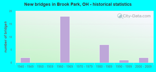
- New bridges - historical statistics
- 21940-1949
- 181960-1969
- 71980-1989
- 11990-1999
- 22000-2009


- Bridge Condition - Deck
- 68.8%Good
- 18.8%Satisfactory
- 6.3%Fair
- 6.3%Poor

- Bridge Condition - Superstructure
- 6.3%Very good
- 68.8%Good
- 18.8%Satisfactory
- 6.3%Poor

- Bridge Condition - Substructure
- 6.3%Very good
- 56.3%Good
- 31.3%Satisfactory
- 6.3%Fair

- Bridge Condition - Channel
- 42.9%Good
- 42.9%Satisfactory
- 14.3%Poor

- Bridge Condition - Culverts
- 33.3%Good
- 66.7%Satisfactory
Find on map >> Show street view
Structure Number: 1802135, Location: APPROX 2000FT E SR237 (Lat: 41.418689, Lng: -81.819089), Route carried "on" structure: State highway 17, Year Built: 1967, Status: Open, Structure Length: 0.76m (2.49ft), Average Daily Traffic: 11,224 (year 2015), Truck Traffic: 6%, Average Future Daily Traffic: 15,579 (year 2035), Design Load: HS 20, Features Intersected: BRANCH BIG CREEK (FORD)
Minimum Vertical Clearance: 30+ m (98+ ft), Kilometerpoint: 8.159, Lanes on structure: 6, Owner: State Highway Agency, Approaching Roadway Width: 22.3m (73.2ft), Skew: 3 degrees, Material/Design: Concrete, Design/Construction: Culvert, Number Of Spans In Main Unit: 1, Length of Maximum Span: 6.7m (22.0ft)
Condition: Channel: Good, Culverts: Satisfactory, Operating Rating: 68.0 metric tons, Method Used To Determine Operating Rating: Load Factor (LF) rating reported by rating factor (RF) method using MS18 loading, Inventory Rating: 42.1 metric tons, Method Used To Determine Inventory Rating: Load Factor (LF) rating reported by rating factor (RF) method using MS18 loading, Structural Evaluation: Equal to present minimum criteria, Waterway Adequacy: Equal to present desirable criteria, Approach Roadway Alignment: Equal to present desirable criteria, Designated Inspection Frequency: Every 12 months, Inspection Date: November 2021
Find on map >> Show street view
Structure Number: 1802194, Location: APPROX 3000FT E I-71 (Lat: 41.418569, Lng: -81.804139), Route carried "on" structure: State highway 17, Year Built: 1967, Status: Open, Structure Length: 1.13m (3.71ft), Average Daily Traffic: 11,224 (year 2015), Truck Traffic: 6%, Average Future Daily Traffic: 15,579 (year 2035), Design Load: HS 20, Features Intersected: WEST BRANCH OF BIG CREEK
Minimum Vertical Clearance: 30+ m (98+ ft), Kilometerpoint: 9.415, Lanes on structure: 4, Owner: State Highway Agency, Approaching Roadway Width: 20.1m (65.9ft), Material/Design: Concrete, Design/Construction: Slab, Number Of Spans In Main Unit: 1, Length of Maximum Span: 10.4m (34.1ft), Curb or Sidewalk Widths: Left: 1.5m (4.9ft), Right: 1.5m (4.9ft), Curb-To-Curb Width: 20.1m (65.9ft), Out-to-Out Width: 22.6m (74.1ft)
Condition: Deck: Good, Superstructure: Good, Substructure: Satisfactory, Channel: Good, Operating Rating: 42.1 metric tons, Method Used To Determine Operating Rating: Load Factor (LF) rating reported by rating factor (RF) method using MS18 loading, Inventory Rating: 32.4 metric tons, Method Used To Determine Inventory Rating: Load Factor (LF) rating reported by rating factor (RF) method using MS18 loading, Structural Evaluation: Equal to present minimum criteria, Deck Geometry: Better than present minimum criteria, Waterway Adequacy: Better than present minimum criteria, Approach Roadway Alignment: Meets minimum limits, Designated Inspection Frequency: Every 12 months, Inspection Date: January 2021, Deck Structure Type: Concrete Cast-file-Place, Wearing Surface/Protective System: Wearing Surface: Bituminous
Find on map >> Show street view
Structure Number: 1804294, Location: 2.34 MI. N. OF JCT. US-42 (Lat: 41.388731, Lng: -81.817111), Route carried "on" structure: County highway C0131, Year Built: 1966, Year Reconstructed: 1999, Status: Open, Structure Length: 7.01m (23.00ft), Average Daily Traffic: 8,230 (year 2016), Truck Traffic: 6%, Average Future Daily Traffic: 11,423 (year 2036), Design Load: H 20, Features Intersected: IR 71, Facility Carried by Structure: SHELDON RD CR-131
Minimum Vertical Clearance: 30+ m (98+ ft), Kilometerpoint: 4.215, Lanes on structure: 2, Lanes under structure: 6, Owner: State Highway Agency, Approaching Roadway Width: 10.4m (34.1ft), Material/Design: Steel continuous, Design/Construction: Stringer/Multi-beam, Number Of Spans In Main Unit: 4, Length of Maximum Span: 19.2m (63.0ft), Curb or Sidewalk Widths: Left: 1.5m (4.9ft), Right: 1.5m (4.9ft), Curb-To-Curb Width: 8.5m (27.9ft), Out-to-Out Width: 12.2m (40.0ft)
Condition: Deck: Good, Superstructure: Good, Substructure: Satisfactory, Operating Rating: 42.1 metric tons, Method Used To Determine Operating Rating: Load Factor (LF) rating reported by rating factor (RF) method using MS18 loading, Inventory Rating: 32.4 metric tons, Method Used To Determine Inventory Rating: Load Factor (LF) rating reported by rating factor (RF) method using MS18 loading, Structural Evaluation: Equal to present minimum criteria, Deck Geometry: Meets minimum limits, Underclear: Somewhat better than minimum adequacy, Approach Roadway Alignment: Equal to present desirable criteria, Designated Inspection Frequency: Every 12 months, Inspection Date: January 2021, Deck Structure Type: Concrete Cast-file-Place, Wearing Surface/Protective System: Wearing Surface: Monolithic Concrete
Find on map >> Show street view
Structure Number: 1804324, Location: 2.82 MI. N. OF JCT. US-42 (Lat: 41.395739, Lng: -81.815661), Route carried "on" structure: Interstate 71, Year Built: 1966, Year Reconstructed: 1999, Status: Open, Structure Length: 4.79m (15.72ft), Average Daily Traffic: 111,588 (year 2015), Truck Traffic: 3%, Average Future Daily Traffic: 154,884 (year 2035), Design Load: HS 20+Mod, Features Intersected: HOLLAND RD
Minimum Vertical Clearance: 30+ m (98+ ft), Kilometerpoint: 13.438, Lanes on structure: 6, Lanes under structure: 2, Base Highway Network: Yes, Owner: State Highway Agency, Approaching Roadway Width: 32.9m (107.9ft), Skew: 30 degrees, Material/Design: Steel continuous, Design/Construction: Stringer/Multi-beam, Number Of Spans In Main Unit: 3, Length of Maximum Span: 19.2m (63.0ft), Curb-To-Curb Width: 31.7m (104.0ft), Out-to-Out Width: 33.5m (109.9ft)
Condition: Deck: Good, Superstructure: Good, Substructure: Good, Operating Rating: 42.1 metric tons, Method Used To Determine Operating Rating: Allowable Stress (AS) rating reported by rating factor (RF) method using MS18 loading, Inventory Rating: 32.4 metric tons, Method Used To Determine Inventory Rating: Allowable Stress (AS) rating reported by rating factor (RF) method using MS18 loading, Structural Evaluation: Better than present minimum criteria, Deck Geometry: Superior to present desirable criteria, Underclear: Equal to present minimum criteria, Approach Roadway Alignment: Equal to present desirable criteria, Designated Inspection Frequency: Every 24 months, Inspection Date: December 2021, Deck Structure Type: Concrete Cast-file-Place, Wearing Surface/Protective System: Wearing Surface: Monolithic Concrete
Find on map >> Show street view
Structure Number: 1804359, Location: 1.43 MI. S. OF JCT. I-480 (Lat: 41.398769, Lng: -81.816550), Route carried "on" structure: Interstate 71, Year Built: 1966, Year Reconstructed: 1999, Status: Open, Structure Length: 3.90m (12.80ft), Average Daily Traffic: 111,588 (year 2015), Truck Traffic: 3%, Average Future Daily Traffic: 154,884 (year 2035), Design Load: HS 20+Mod, Features Intersected: SYLVIA DR
Minimum Vertical Clearance: 30+ m (98+ ft), Kilometerpoint: 13.776, Lanes on structure: 6, Lanes under structure: 2, Base Highway Network: Yes, Owner: State Highway Agency, Approaching Roadway Width: 41.5m (136.2ft), Skew: 11 degrees, Material/Design: Steel continuous, Design/Construction: Stringer/Multi-beam, Number Of Spans In Main Unit: 3, Length of Maximum Span: 15.5m (50.9ft), Curb-To-Curb Width: 40.8m (133.9ft), Out-to-Out Width: 42.1m (138.1ft)
Condition: Deck: Good, Superstructure: Good, Substructure: Good, Operating Rating: 42.1 metric tons, Method Used To Determine Operating Rating: Allowable Stress (AS) rating reported by rating factor (RF) method using MS18 loading, Inventory Rating: 32.4 metric tons, Method Used To Determine Inventory Rating: Allowable Stress (AS) rating reported by rating factor (RF) method using MS18 loading, Structural Evaluation: Better than present minimum criteria, Deck Geometry: Superior to present desirable criteria, Underclear: Equal to present minimum criteria, Approach Roadway Alignment: Equal to present desirable criteria, Designated Inspection Frequency: Every 24 months, Inspection Date: December 2021, Deck Structure Type: Concrete Cast-file-Place, Wearing Surface/Protective System: Wearing Surface: Monolithic Concrete
Find on map >> Show street view
Structure Number: 1804383, Location: 1.15 MI. S. OF JCT. I-480 (Lat: 41.402689, Lng: -81.817919), Route carried "on" structure: Interstate 71, Year Built: 1966, Year Reconstructed: 1999, Status: Open, Structure Length: 5.33m (17.49ft), Average Daily Traffic: 111,588 (year 2015), Truck Traffic: 3%, Average Future Daily Traffic: 154,884 (year 2035), Design Load: HS 20+Mod, Features Intersected: CR 87 (SNOW RD)
Minimum Vertical Clearance: 30+ m (98+ ft), Kilometerpoint: 14.227, Lanes on structure: 7, Lanes under structure: 2, Base Highway Network: Yes, Owner: State Highway Agency, Approaching Roadway Width: 40.8m (133.9ft), Skew: 10 degrees, Material/Design: Steel continuous, Design/Construction: Stringer/Multi-beam, Number Of Spans In Main Unit: 4, Length of Maximum Span: 17.1m (56.1ft), Curb-To-Curb Width: 40.2m (131.9ft), Out-to-Out Width: 41.7m (136.8ft)
Condition: Deck: Good, Superstructure: Satisfactory, Substructure: Satisfactory, Operating Rating: 42.1 metric tons, Method Used To Determine Operating Rating: Allowable Stress (AS) rating reported by rating factor (RF) method using MS18 loading, Inventory Rating: 32.4 metric tons, Method Used To Determine Inventory Rating: Allowable Stress (AS) rating reported by rating factor (RF) method using MS18 loading, Structural Evaluation: Equal to present minimum criteria, Deck Geometry: Superior to present desirable criteria, Underclear: High priority of corrective action, Approach Roadway Alignment: Equal to present desirable criteria, Designated Inspection Frequency: Every 12 months, Inspection Date: December 2021, Deck Structure Type: Concrete Cast-file-Place, Wearing Surface/Protective System: Wearing Surface: Low Slump Concrete
Find on map >> Show street view
Structure Number: 1804413, Location: .86 MI. S. OF JCT. I-480 (Lat: 41.406819, Lng: -81.818219), Route carried "on" structure: Interstate 71, Year Built: 1966, Year Reconstructed: 1999, Status: Open, Structure Length: 6.52m (21.39ft), Average Daily Traffic: 113,699 (year 2015), Truck Traffic: 3%, Average Future Daily Traffic: 157,814 (year 2035), Design Load: HS 20+Mod, Features Intersected: CSX RAILROAD
Minimum Vertical Clearance: 30+ m (98+ ft), Kilometerpoint: 14.693, Lanes on structure: 8, Base Highway Network: Yes, Owner: State Highway Agency, Approaching Roadway Width: 38.1m (125.0ft), Skew: 14 degrees, Material/Design: Steel continuous, Design/Construction: Stringer/Multi-beam, Number Of Spans In Main Unit: 3, Length of Maximum Span: 24.4m (80.1ft), Curb-To-Curb Width: 37.5m (123.0ft), Out-to-Out Width: 38.7m (127.0ft)
Condition: Deck: Good, Superstructure: Good, Substructure: Satisfactory, Operating Rating: 42.1 metric tons, Method Used To Determine Operating Rating: Allowable Stress (AS) rating reported by rating factor (RF) method using MS18 loading, Inventory Rating: 32.4 metric tons, Method Used To Determine Inventory Rating: Allowable Stress (AS) rating reported by rating factor (RF) method using MS18 loading, Structural Evaluation: Equal to present minimum criteria, Deck Geometry: Superior to present desirable criteria, Underclear: Better than present minimum criteria, Approach Roadway Alignment: Equal to present desirable criteria, Designated Inspection Frequency: Every 12 months, Inspection Date: December 2021, Deck Structure Type: Concrete Cast-file-Place, Wearing Surface/Protective System: Wearing Surface: Monolithic Concrete
Find on map >> Show street view
Structure Number: 1804448, Location: .76 MI. S. OF JCT. I-480 (Lat: 41.408289, Lng: -81.818119), Route carried "on" structure: Interstate 71, Year Built: 1966, Year Reconstructed: 1999, Status: Open, Structure Length: 4.75m (15.58ft), Average Daily Traffic: 113,699 (year 2015), Truck Traffic: 3%, Average Future Daily Traffic: 157,814 (year 2035), Design Load: HS 20+Mod, Features Intersected: HUMMEL RD
Minimum Vertical Clearance: 30+ m (98+ ft), Kilometerpoint: 14.854, Lanes on structure: 8, Lanes under structure: 2, Base Highway Network: Yes, Owner: State Highway Agency, Approaching Roadway Width: 40.2m (131.9ft), Skew: 10 degrees, Material/Design: Steel continuous, Design/Construction: Stringer/Multi-beam, Number Of Spans In Main Unit: 3, Length of Maximum Span: 19.2m (63.0ft), Curb-To-Curb Width: 39.6m (129.9ft), Out-to-Out Width: 40.8m (133.9ft)
Condition: Deck: Good, Superstructure: Good, Substructure: Very good, Operating Rating: 42.1 metric tons, Method Used To Determine Operating Rating: Allowable Stress (AS) rating reported by rating factor (RF) method using MS18 loading, Inventory Rating: 32.4 metric tons, Method Used To Determine Inventory Rating: Allowable Stress (AS) rating reported by rating factor (RF) method using MS18 loading, Structural Evaluation: Better than present minimum criteria, Deck Geometry: Superior to present desirable criteria, Underclear: Equal to present desirable criteria, Approach Roadway Alignment: Equal to present desirable criteria, Designated Inspection Frequency: Every 24 months, Inspection Date: December 2021, Deck Structure Type: Concrete Cast-file-Place, Wearing Surface/Protective System: Wearing Surface: Monolithic Concrete
Find on map >> Show street view
Structure Number: 1810235, Location: .95 MI S SNOW ROAD (Lat: 41.394150, Lng: -81.847011), Route carried "on" structure: State highway 237, Year Built: 1943, Status: Open, Structure Length: 2.32m (7.61ft), Average Daily Traffic: 28,886 (year 2015), Truck Traffic: 7%, Average Future Daily Traffic: 40,094 (year 2035), Design Load: HS 20, Features Intersected: I-X CNTR DR (KOLTHOFF DR
Minimum Vertical Clearance: 30+ m (98+ ft), Kilometerpoint: 9.656, Lanes on structure: 4, Lanes under structure: 4, Base Highway Network: Yes, Owner: State Highway Agency, Approaching Roadway Width: 19.5m (64.0ft), Skew: 20 degrees, Material/Design: Concrete, Design/Construction: Frame, Number Of Spans In Main Unit: 1, Length of Maximum Span: 23.2m (76.1ft), Curb-To-Curb Width: 16.9m (55.4ft), Out-to-Out Width: 19.6m (64.3ft)
Condition: Deck: Satisfactory, Superstructure: Satisfactory, Substructure: Good, Operating Rating: 22.9 metric tons, Method Used To Determine Operating Rating: Field evaluation and documented engineering judgment, Inventory Rating: 18.3 metric tons, Method Used To Determine Inventory Rating: Field evaluation and documented engineering judgment, Structural Evaluation: Meets minimum limits, Deck Geometry: Somewhat better than minimum adequacy, Underclear: Meets minimum limits, Approach Roadway Alignment: Equal to present minimum criteria, Designated Inspection Frequency: Every 12 months, Inspection Date: January 2021, Deck Structure Type: Concrete Cast-file-Place, Wearing Surface/Protective System: Wearing Surface: Integral Concrete
Find on map >> Show street view
Structure Number: 1810286, Location: APPROX 1MI E KOLTHOFF DR (Lat: 41.404600, Lng: -81.836769), Route carried "on" structure: State highway 237, Year Built: 1987, Status: Open, Structure Length: 2.56m (8.40ft), Average Daily Traffic: 31,223 (year 2015), Truck Traffic: 4%, Average Future Daily Traffic: 43,338 (year 2035), Design Load: HS 20+Mod, Features Intersected: SNOW ROAD
Minimum Vertical Clearance: 30+ m (98+ ft), Kilometerpoint: 11.185, Lanes on structure: 4, Lanes under structure: 4, Base Highway Network: Yes, Owner: State Highway Agency, Approaching Roadway Width: 25.3m (83.0ft), Skew: 10 degrees, Material/Design: Prestressed concrete, Design/Construction: Box Beam or Girders - Multiple, Number Of Spans In Main Unit: 1, Length of Maximum Span: 24.4m (80.1ft), Curb-To-Curb Width: 25.2m (82.7ft), Out-to-Out Width: 26.3m (86.3ft)
Condition: Deck: Poor, Superstructure: Poor, Substructure: Fair, Operating Rating: 42.1 metric tons, Method Used To Determine Operating Rating: Load Factor (LF) rating reported by rating factor (RF) method using MS18 loading, Inventory Rating: 32.4 metric tons, Method Used To Determine Inventory Rating: Load Factor (LF) rating reported by rating factor (RF) method using MS18 loading, Structural Evaluation: Meets minimum limits, Deck Geometry: Superior to present desirable criteria, Underclear: Equal to present minimum criteria, Approach Roadway Alignment: Equal to present desirable criteria, Designated Inspection Frequency: Every 12 months, Inspection Date: May 2021, Deck Structure Type: Concrete Cast-file-Place, Wearing Surface/Protective System: Wearing Surface: Bituminous
Find on map >> Show street view
Structure Number: 1810308, Location: 1.13 MI S SR 17 (Lat: 41.407839, Lng: -81.834711), Route carried "on" structure: Ramp State highway 237, Year Built: 1987, Status: Open, Structure Length: 6.28m (20.60ft), Average Daily Traffic: 27,060 (year 2014), Truck Traffic: 3%, Average Future Daily Traffic: 37,559 (year 2034), Design Load: HS 20+Mod, Features Intersected: SR 237, Facility Carried by Structure: INNER DR
Minimum Vertical Clearance: 30+ m (98+ ft), Kilometerpoint: 11.531, Lanes on structure: 2, Lanes under structure: 6, Owner: State Highway Agency, Approaching Roadway Width: 11.0m (36.1ft), Material/Design: Steel continuous, Design/Construction: Stringer/Multi-beam, Number Of Spans In Main Unit: 3, Length of Maximum Span: 23.2m (76.1ft), Curb-To-Curb Width: 10.6m (34.8ft), Out-to-Out Width: 11.6m (38.1ft)
Condition: Deck: Satisfactory, Superstructure: Good, Substructure: Satisfactory, Operating Rating: 42.1 metric tons, Method Used To Determine Operating Rating: Load Factor (LF) rating reported by rating factor (RF) method using MS18 loading, Inventory Rating: 32.4 metric tons, Method Used To Determine Inventory Rating: Load Factor (LF) rating reported by rating factor (RF) method using MS18 loading, Structural Evaluation: Equal to present minimum criteria, Deck Geometry: Better than present minimum criteria, Underclear: Meets minimum limits, Approach Roadway Alignment: Equal to present minimum criteria, Designated Inspection Frequency: Every 12 months, Inspection Date: May 2021, Deck Structure Type: Concrete Cast-file-Place, Wearing Surface/Protective System: Wearing Surface: Monolithic Concrete, Deck Protection: Epoxy Coated Reinforcing
Find on map >> Show street view
Structure Number: 1810316, Location: 0.98 MI S SR 17 (Lat: 41.410131, Lng: -81.832411), Route carried "on" structure: State highway 237, Year Built: 1965, Status: Open, Structure Length: 0.91m (2.99ft), Average Daily Traffic: 31,223 (year 2015), Truck Traffic: 4%, Average Future Daily Traffic: 43,338 (year 2035), Design Load: HS 20, Features Intersected: RTA94 BETWEEN AIRPT RAMP, Facility Carried by Structure: RTA
Minimum Vertical Clearance: 30+ m (98+ ft), Kilometerpoint: 11.829, Lanes on structure: 6, Base Highway Network: Yes, Owner: State Highway Agency, Approaching Roadway Width: 35.4m (116.1ft), Skew: 39 degrees, Material/Design: Concrete, Design/Construction: Tee Beam, Number Of Spans In Main Unit: 1, Length of Maximum Span: 9.1m (29.9ft), Curb-To-Curb Width: 35.4m (116.1ft), Out-to-Out Width: 35.4m (116.1ft)
Condition: Deck: Good, Superstructure: Good, Substructure: Good, Operating Rating: 40.8 metric tons, Method Used To Determine Operating Rating: Field evaluation and documented engineering judgment, Inventory Rating: 32.7 metric tons, Method Used To Determine Inventory Rating: Field evaluation and documented engineering judgment, Structural Evaluation: Better than present minimum criteria, Deck Geometry: Superior to present desirable criteria, Underclear: High priority of corrective action, Approach Roadway Alignment: Equal to present desirable criteria, Designated Inspection Frequency: Every 24 months, Inspection Date: November 2021, Deck Structure Type: Concrete Cast-file-Place
Find on map >> Show street view
Structure Number: 1810324, Location: 0.85 MI S SR 17 (Lat: 41.411319, Lng: -81.831639), Route carried "on" structure: Ramp State highway 237, Year Built: 1986, Status: Open, Structure Length: 23.07m (75.69ft), Average Daily Traffic: 39,590 (year 2010), Truck Traffic: 4%, Average Future Daily Traffic: 54,951 (year 2030), Design Load: HS 20+Mod, Features Intersected: NB EXIT TO AIRPORT-RTA94
Minimum Vertical Clearance: 30+ m (98+ ft), Kilometerpoint: 12.038, Lanes on structure: 2, Lanes under structure: 8, Owner: State Highway Agency, Approaching Roadway Width: 8.2m (26.9ft), Skew: 3 degrees, Material/Design: Steel continuous, Design/Construction: Stringer/Multi-beam, Number Of Spans In Main Unit: 8, Length of Maximum Span: 40.8m (133.9ft), Curb-To-Curb Width: 8.2m (26.9ft), Out-to-Out Width: 9.2m (30.2ft)
Condition: Deck: Good, Superstructure: Good, Substructure: Good, Operating Rating: 42.1 metric tons, Method Used To Determine Operating Rating: Load Factor (LF) rating reported by rating factor (RF) method using MS18 loading, Inventory Rating: 32.4 metric tons, Method Used To Determine Inventory Rating: Load Factor (LF) rating reported by rating factor (RF) method using MS18 loading, Structural Evaluation: Better than present minimum criteria, Deck Geometry: High priority of corrective action, Underclear: Equal to present minimum criteria, Approach Roadway Alignment: Equal to present desirable criteria, Designated Inspection Frequency: Every 24 months, Inspection Date: November 2021, Deck Structure Type: Concrete Cast-file-Place, Wearing Surface/Protective System: Wearing Surface: Monolithic Concrete, Deck Protection: Epoxy Coated Reinforcing
Find on map >> Show street view
Structure Number: 1811967, Location: 0.25 MI. WEST OF I-71 (Lat: 41.403139, Lng: -81.825311), Route carried "on" structure: County highway C0087, Year Built: 1968, Status: Open, Structure Length: 26.76m (87.80ft), Average Daily Traffic: 28,403 (year 2015), Truck Traffic: 7%, Average Future Daily Traffic: 39,423 (year 2035), Design Load: HS 20+Mod, Features Intersected: SR-291 & CSX RR, Facility Carried by Structure: SNOW RD CR-87
Minimum Vertical Clearance: 30+ m (98+ ft), Kilometerpoint: 0.381, Lanes on structure: 4, Lanes under structure: 2, Base Highway Network: Yes, Owner: State Highway Agency, Approaching Roadway Width: 16.5m (54.1ft), Skew: 3 degrees, Material/Design: Steel continuous, Design/Construction: Frame, Number Of Spans In Main Unit: 7, Length of Maximum Span: 41.8m (137.1ft), Curb or Sidewalk Widths: Left: 1.2m (3.9ft), Right: 1.2m (3.9ft), Curb-To-Curb Width: 16.5m (54.1ft), Out-to-Out Width: 19.5m (64.0ft)
Condition: Deck: Fair, Superstructure: Good, Substructure: Good, Operating Rating: 55.1 metric tons, Method Used To Determine Operating Rating: Load Factor (LF) rating reported by rating factor (RF) method using MS18 loading, Inventory Rating: 35.6 metric tons, Method Used To Determine Inventory Rating: Load Factor (LF) rating reported by rating factor (RF) method using MS18 loading, Structural Evaluation: Better than present minimum criteria, Deck Geometry: Meets minimum limits, Underclear: Superior to present desirable criteria, Approach Roadway Alignment: Equal to present minimum criteria, Designated Inspection Frequency: Every 12 months, Inspection Date: October 2021, Deck Structure Type: Concrete Cast-file-Place, Wearing Surface/Protective System: Wearing Surface: Integral Concrete
Find on map >> Show street view
Structure Number: 1830163, Location: 880 FT. E. OF SMITH ROAD (Lat: 41.403831, Lng: -81.800861), Route carried "on" structure: County highway C0087, Year Built: 1961, Status: Open, Structure Length: 0.73m (2.40ft), Average Daily Traffic: 21,958 (year 2017), Truck Traffic: 7%, Average Future Daily Traffic: 30,478 (year 2037), Design Load: H 20, Features Intersected: BRANCH BIG CREEK, Facility Carried by Structure: SNOW ROAD CR 87
Minimum Vertical Clearance: 30+ m (98+ ft), Kilometerpoint: 2.398, Lanes on structure: 4, Base Highway Network: Yes, Owner: County Highway Agency, Approaching Roadway Width: 15.9m (52.2ft), Skew: 1 degrees, Material/Design: Steel, Design/Construction: Culvert, Number Of Spans In Main Unit: 2, Length of Maximum Span: 7.3m (24.0ft)
Condition: Channel: Good, Culverts: Satisfactory, Operating Rating: 97.2 metric tons, Method Used To Determine Operating Rating: Load and Resistance Factor Rating (LRFR) rating reported by rating factor(RF) method using HL-93 loadings, Inventory Rating: 87.5 metric tons, Method Used To Determine Inventory Rating: Load and Resistance Factor Rating (LRFR) rating reported by rating factor(RF) method using HL-93 loadings, Structural Evaluation: Equal to present minimum criteria, Waterway Adequacy: Equal to present desirable criteria, Approach Roadway Alignment: Equal to present desirable criteria, Designated Inspection Frequency: Every 12 months, Inspection Date: April 2021
Find on map >> Show street view
Structure Number: 1832549, Location: 560 FT NW OF RUPLE RD (Lat: 41.396239, Lng: -81.881239), Route carried "on" structure: County highway 316, Year Built: 2003, Status: Open, Structure Length: 3.26m (10.70ft), Average Daily Traffic: 1,949 (year 2015), Truck Traffic: 5%, Average Future Daily Traffic: 2,705 (year 2035), Design Load: HS 20+Mod, Features Intersected: EAST BR ROCKY RIVER
Minimum Vertical Clearance: 30+ m (98+ ft), Kilometerpoint: 0.724, Lanes on structure: 2, Owner: County Highway Agency, Approaching Roadway Width: 7.3m (24.0ft), Material/Design: Prestressed concrete, Design/Construction: Stringer/Multi-beam, Number Of Spans In Main Unit: 1, Length of Maximum Span: 32.0m (105.0ft), Curb or Sidewalk Widths: Left: 1.5m (4.9ft), Right: 1.5m (4.9ft), Curb-To-Curb Width: 8.5m (27.9ft), Out-to-Out Width: 12.2m (40.0ft)
Condition: Deck: Good, Superstructure: Very good, Substructure: Good, Channel: Poor, Operating Rating: 42.1 metric tons, Method Used To Determine Operating Rating: Load Factor (LF) rating reported by rating factor (RF) method using MS18 loading, Inventory Rating: 32.4 metric tons, Method Used To Determine Inventory Rating: Load Factor (LF) rating reported by rating factor (RF) method using MS18 loading, Structural Evaluation: Better than present minimum criteria, Deck Geometry: Somewhat better than minimum adequacy, Waterway Adequacy: Superior to present desirable criteria, Approach Roadway Alignment: Equal to present desirable criteria, Designated Inspection Frequency: Every 24 months, Inspection Date: August 2021, Deck Structure Type: Concrete Cast-file-Place, Wearing Surface/Protective System: Wearing Surface: Monolithic Concrete, Deck Protection: Epoxy Coated Reinforcing
Find on map >> Show street view
Structure Number: 1832751, Location: 966 FT N OF SHELDON ROAD (Lat: 41.392150, Lng: -81.842711), Route carried "on" structure: County highway 186, Year Built: 2009, Status: Open, Structure Length: 1.04m (3.41ft), Average Daily Traffic: 6,488 (year 2015), Truck Traffic: 5%, Average Future Daily Traffic: 9,005 (year 2035), Design Load: HS 20+Mod, Features Intersected: LAKE ABRAMS DITCH
Minimum Vertical Clearance: 30+ m (98+ ft), Kilometerpoint: 3.460, Lanes on structure: 2, Owner: County Highway Agency, Approaching Roadway Width: 11.9m (39.0ft), Material/Design: Concrete, Design/Construction: Culvert, Number Of Spans In Main Unit: 1, Length of Maximum Span: 10.1m (33.1ft), Curb or Sidewalk Widths: Left: 1.5m (4.9ft), Right: 1.5m (4.9ft)
Condition: Channel: Satisfactory, Culverts: Good, Operating Rating: 42.1 metric tons, Method Used To Determine Operating Rating: Load Factor (LF) rating reported by rating factor (RF) method using MS18 loading, Inventory Rating: 32.4 metric tons, Method Used To Determine Inventory Rating: Load Factor (LF) rating reported by rating factor (RF) method using MS18 loading, Structural Evaluation: Better than present minimum criteria, Waterway Adequacy: Superior to present desirable criteria, Approach Roadway Alignment: Superior to present desirable criteria, Designated Inspection Frequency: Every 24 months, Inspection Date: July 2021, Wearing Surface/Protective System: Wearing Surface: Monolithic Concrete, Membrane: Built-up, Deck Protection: Epoxy Coated Reinforcing
Find on map >> Show street view
Structure Number: 1833375, Location: 704' N OF HUMMEL RD (Lat: 41.409761, Lng: -81.803739), Route carried "on" structure: County highway 64, Year Built: 1962, Status: Open, Structure Length: 0.70m (2.30ft), Average Daily Traffic: 14,318 (year 2015), Truck Traffic: 3%, Average Future Daily Traffic: 19,873 (year 2035), Design Load: H 15, Features Intersected: WEST BR BIG CREEK
Minimum Vertical Clearance: 30+ m (98+ ft), Kilometerpoint: 4.892, Lanes on structure: 4, Owner: County Highway Agency, Approaching Roadway Width: 18.3m (60.0ft), Skew: 1 degrees, Material/Design: Concrete, Design/Construction: Slab, Number Of Spans In Main Unit: 1, Length of Maximum Span: 6.1m (20.0ft), Curb or Sidewalk Widths: Left: 1.5m (4.9ft), Right: 1.5m (4.9ft), Curb-To-Curb Width: 15.9m (52.2ft), Out-to-Out Width: 15.9m (52.2ft)
Condition: Deck: Satisfactory, Superstructure: Satisfactory, Substructure: Good, Channel: Satisfactory, Operating Rating: 36.6 metric tons, Method Used To Determine Operating Rating: Load and Resistance Factor Rating (LRFR) rating reported by rating factor(RF) method using HL-93 loadings, Inventory Rating: 28.2 metric tons, Method Used To Determine Inventory Rating: Load and Resistance Factor Rating (LRFR) rating reported by rating factor(RF) method using HL-93 loadings, Structural Evaluation: Equal to present minimum criteria, Deck Geometry: Meets minimum limits, Waterway Adequacy: Superior to present desirable criteria, Approach Roadway Alignment: Equal to present desirable criteria, Designated Inspection Frequency: Every 12 months, Inspection Date: July 2021, Deck Structure Type: Concrete Cast-file-Place, Wearing Surface/Protective System: Wearing Surface: Monolithic Concrete
Find on map >> Show street view
Structure Number: 1891138, Location: 500 ft S. Spafford Rd (Lat: 41.395789, Lng: -81.882861), Route carried "on" structure: Other road CMP, Year Built: 1998, Status: Open, Structure Length: 1.65m (5.41ft), Average Daily Traffic: 4,000 (year 2000), Truck Traffic: 1%, Average Future Daily Traffic: 5,552 (year 2020), Design Load: HS 20+Mod, Features Intersected: East Branch Rocky River, Facility Carried by Structure: Valley Parkway
Minimum Vertical Clearance: 30+ m (98+ ft), Kilometerpoint: 0.000, Lanes on structure: 2, Owner: Local Park, Forest, or Reservation Agency, Approaching Roadway Width: 7.0m (23.0ft), Material/Design: Concrete, Design/Construction: Frame, Number Of Spans In Main Unit: 2, Length of Maximum Span: 7.3m (24.0ft), Curb-To-Curb Width: 7.9m (25.9ft), Out-to-Out Width: 8.5m (27.9ft)
Condition: Deck: Good, Superstructure: Good, Substructure: Good, Channel: Satisfactory, Operating Rating: 42.1 metric tons, Method Used To Determine Operating Rating: Assigned rating based on Load Factor Design (LFD) reported by rating factor (RF) using MS18 loading, Inventory Rating: 32.4 metric tons, Method Used To Determine Inventory Rating: Assigned rating based on Load Factor Design (LFD) reported by rating factor (RF) using MS18 loading, Structural Evaluation: Better than present minimum criteria, Deck Geometry: High priority of corrective action, Waterway Adequacy: High priority of corrective action, Approach Roadway Alignment: Equal to present desirable criteria, Designated Inspection Frequency: Every 24 months, Inspection Date: July 2021, Deck Structure Type: Concrete Cast-file-Place, Wearing Surface/Protective System: Wearing Surface: Monolithic Concrete, Deck Protection: Epoxy Coated Reinforcing
Find on map >> Show street view
Structure Number: 1804294, Location: 2.34 MI. N. OF JCT. US-42 (Lat: 41.388731, Lng: -81.817111), Route carried "under" structure: Interstate 71, Year Built: 1966, Structure Length: 0. m, Average Daily Traffic: 112,228 (year 2016), Truck Traffic: 3%, Features Intersected: CR-131 (SHELDON RD), Facility Carried by Structure: SHELDON RD CR-131
Minimum Vertical Clearance: 5.16m (16.93ft), Kilometerpoint: 12.666, Lanes on structure: 2, Lanes under structure: 6, Material/Design: Steel continuous, Design/Construction: Stringer/Multi-beam, Length of Maximum Span: 19.2m (63.0ft)
Find on map >> Show street view
Structure Number: 1804324, Location: 2.82 MI. N. OF JCT. US-42 (Lat: 41.395739, Lng: -81.815661), Route carried "under" structure: City street HOLND, Year Built: 1966, Structure Length: 0. m, Average Daily Traffic: 1,000 (year 1900), Features Intersected: IR 71, Facility Carried by Structure: Holland St
Minimum Vertical Clearance: 4.57m (14.99ft), Kilometerpoint: 0.000, Lanes on structure: 6, Lanes under structure: 2, Material/Design: Steel continuous, Design/Construction: Stringer/Multi-beam, Length of Maximum Span: 19.2m (63.0ft)
Find on map >> Show street view
Structure Number: 1804359, Location: 1.43 MI. S. OF JCT. I-480 (Lat: 41.398769, Lng: -81.816550), Route carried "under" structure: City street SYLVI, Year Built: 1966, Structure Length: 0. m, Average Daily Traffic: 1,000 (year 1900), Features Intersected: IR 71, Facility Carried by Structure: Sylvia Dr
Minimum Vertical Clearance: 4.65m (15.26ft), Kilometerpoint: 0.000, Lanes on structure: 6, Lanes under structure: 2, Material/Design: Steel continuous, Design/Construction: Stringer/Multi-beam, Length of Maximum Span: 15.5m (50.9ft)
Find on map >> Show street view
Structure Number: 1804383, Location: 1.15 MI. S. OF JCT. I-480 (Lat: 41.402689, Lng: -81.817919), Route carried "under" structure: County highway C0087, Year Built: 1966, Structure Length: 0. m, Average Daily Traffic: 28,403 (year 2015), Truck Traffic: 7%, Features Intersected: I-71, Facility Carried by Structure: Snow Rd
Minimum Vertical Clearance: 4.62m (15.16ft), Kilometerpoint: 0.853, Lanes on structure: 7, Lanes under structure: 2, Material/Design: Steel continuous, Design/Construction: Stringer/Multi-beam, Length of Maximum Span: 17.1m (56.1ft)
Find on map >> Show street view
Structure Number: 1804448, Location: .76 MI. S. OF JCT. I-480 (Lat: 41.408289, Lng: -81.818119), Route carried "under" structure: City street HUMEL, Year Built: 1966, Structure Length: 0. m, Average Daily Traffic: 1,000 (year 1900), Features Intersected: I-71, Facility Carried by Structure: IR 71
Minimum Vertical Clearance: 6.25m (20.51ft), Kilometerpoint: 0.000, Lanes on structure: 8, Lanes under structure: 2, Material/Design: Steel continuous, Design/Construction: Stringer/Multi-beam, Length of Maximum Span: 19.2m (63.0ft)
Find on map >> Show street view
Structure Number: 1810235, Location: .95 MI S SNOW ROAD (Lat: 41.394150, Lng: -81.847011), Route carried "under" structure: City street I-X, Year Built: 1943, Structure Length: 0. m, Features Intersected: SR 237, Facility Carried by Structure: SR 237
Minimum Vertical Clearance: 4.62m (15.16ft), Lanes on structure: 4, Lanes under structure: 4, Material/Design: Concrete, Design/Construction: Frame, Length of Maximum Span: 23.2m (76.1ft)
Find on map >> Show street view
Structure Number: 1810286, Location: APPROX 1MI E KOLTHOFF DR (Lat: 41.404600, Lng: -81.836769), Route carried "under" structure: City street SNOW, Year Built: 1987, Structure Length: 0. m, Average Daily Traffic: 10,117 (year 2015), Truck Traffic: 7%, Features Intersected: SR 237, Facility Carried by Structure: SR 237
Minimum Vertical Clearance: 4.74m (15.55ft), Kilometerpoint: 0.000, Lanes on structure: 4, Lanes under structure: 4, Material/Design: Prestressed concrete, Design/Construction: Box Beam or Girders - Multiple, Length of Maximum Span: 24.4m (80.1ft)
Find on map >> Show street view
Structure Number: 1810308, Location: 1.13 MI S SR 17 (Lat: 41.407839, Lng: -81.834711), Route carried "under" structure: County highway C739A, Year Built: 1987, Structure Length: 0. m, Features Intersected: RamptoAirport, Facility Carried by Structure: INNER DR
Minimum Vertical Clearance: 4.36m (14.30ft), Kilometerpoint: 0.161, Lanes on structure: 2, Lanes under structure: 6, Material/Design: Steel continuous, Design/Construction: Stringer/Multi-beam, Length of Maximum Span: 23.2m (76.1ft)
Find on map >> Show street view
Structure Number: 1810308, Location: 1.13 MI S SR 17 (Lat: 41.407839, Lng: -81.834711), Route carried "under" structure: State highway 237, Year Built: 1987, Structure Length: 0. m, Average Daily Traffic: 31,223 (year 2015), Truck Traffic: 4%, Features Intersected: 00237, Facility Carried by Structure: INNER DR
Minimum Vertical Clearance: 4.54m (14.90ft), Kilometerpoint: 11.587, Lanes on structure: 2, Lanes under structure: 6, Material/Design: Steel continuous, Design/Construction: Stringer/Multi-beam, Length of Maximum Span: 23.2m (76.1ft)
Find on map >> Show street view
Structure Number: 1810324, Location: 0.85 MI S SR 17 (Lat: 41.411319, Lng: -81.831639), Route carried "under" structure: State highway 237, Year Built: 1986, Structure Length: 0. m, Average Daily Traffic: 15,728 (year 2015), Truck Traffic: 10%, Features Intersected: SR 237
Minimum Vertical Clearance: 4.89m (16.04ft), Kilometerpoint: 12.038, Lanes on structure: 2, Lanes under structure: 8, Material/Design: Steel continuous, Design/Construction: Stringer/Multi-beam, Length of Maximum Span: 40.8m (133.9ft)
Find on map >> Show street view
Structure Number: 1811967, Location: 0.25 MI. WEST OF I-71 (Lat: 41.403139, Lng: -81.825311), Route carried "under" structure: State highway 291, Year Built: 1968, Structure Length: 0. m, Average Daily Traffic: 13,116 (year 2016), Truck Traffic: 3%, Features Intersected: SNOW RD (CR-87), Facility Carried by Structure: SNOW RD CR-87
Minimum Vertical Clearance: 6.91m (22.67ft), Kilometerpoint: 4.825, Lanes on structure: 4, Lanes under structure: 2, Material/Design: Steel continuous, Design/Construction: Frame, Length of Maximum Span: 41.8m (137.1ft)