Bridge Statistics for Beaumont, California (CA)
Condition, Traffic, Stress, Structural Evaluation, Project Costs
- National Bridge Inventory (NBI) Statistics
- 33Number of bridges
- 335ft / 102mTotal length
- 1,377,111Total average daily traffic
- 147,597Total average daily truck traffic
- National Bridge Inventory (NBI) Registered Bridges for Beaumont
- No street view available for this location
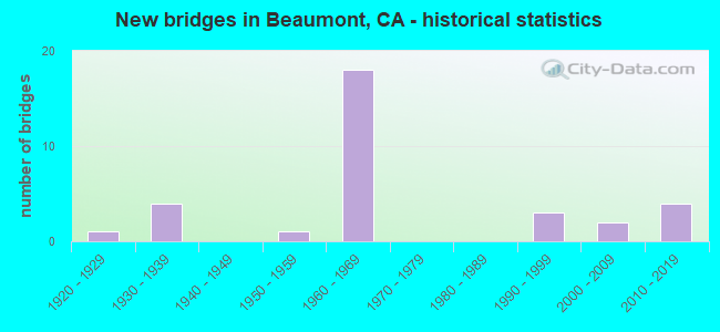
- New bridges - historical statistics
- 11920-1929
- 41930-1939
- 11950-1959
- 181960-1969
- 31990-1999
- 22000-2009
- 42010-2019

- Reconstructed bridges - Historical Statistics
- 11940-1949
- 11950-1959
- 21960-1969
- 41970-1979


- Bridge Condition - Deck
- 62.5%Good
- 6.3%Satisfactory
- 31.3%Fair

- Bridge Condition - Superstructure
- 87.5%Good
- 12.5%Fair

- Bridge Condition - Substructure
- 93.8%Good
- 6.3%Fair

- Bridge Condition - Channel
- 16.7%Excellent
- 33.3%Very good
- 33.3%Good
- 16.7%Fair

- Bridge Condition - Culverts
- 50.0%Good
- 50.0%Satisfactory
Find on map >> Show street view
Structure Number: 56 0065, Location: 08-RIV-060-28.34 (Lat: 33.932608, Lng: -117.027169), Route carried "on" structure: State highway 60, Year Built: 1936, Year Reconstructed: 1959, Status: Open, Structure Length: 1.91m (6.27ft), Average Daily Traffic: 50,000 (year 2020), Truck Traffic: 16%, Average Future Daily Traffic: 99,500 (year 2040), Design Load: H 15, Features Intersected: SAN TIMOTEO CREEK
Minimum Vertical Clearance: 30+ m (98+ ft), Kilometerpoint: 28.340, Lanes on structure: 4, Base Highway Network: Yes (, Subroute: 1), Owner: State Highway Agency, Approaching Roadway Width: 12.8m (42.0ft), Skew: 35 degrees, Material/Design: Concrete, Design/Construction: Girder and Floorbeam System, Number Of Spans In Main Unit: 2, Length of Maximum Span: 9.6m (31.5ft), Curb-To-Curb Width: 25.6m (84.0ft), Out-to-Out Width: 26.5m (86.9ft)
Condition: Deck: Good, Superstructure: Good, Substructure: Good, Channel: Very good, Operating Rating: 36.9 metric tons, Method Used To Determine Operating Rating: Load and Resistance Factor Rating (LRFR) rating reported by rating factor(RF) method using HL-93 loadings, Inventory Rating: 25.9 metric tons, Method Used To Determine Inventory Rating: Load and Resistance Factor Rating (LRFR) rating reported by rating factor(RF) method using HL-93 loadings, Structural Evaluation: Equal to present minimum criteria, Deck Geometry: Superior to present desirable criteria, Waterway Adequacy: Equal to present desirable criteria, Approach Roadway Alignment: Equal to present desirable criteria, Designated Inspection Frequency: Every 24 months, Inspection Date: December 2020, Deck Structure Type: Concrete Cast-file-Place, Wearing Surface/Protective System: Wearing Surface: Bituminous
Find on map >> Show street view
Structure Number: 56 0066L, Location: 08-RIV-060-30.24 (Lat: 33.933275, Lng: -116.994561), Route carried "on" structure: State highway 60, Year Built: 1936, Status: Open, Structure Length: 8.02m (26.31ft), Average Daily Traffic: 44,500 (year 2020), Truck Traffic: 13%, Average Future Daily Traffic: 100,196 (year 2040), Design Load: HS 20, Features Intersected: UP RR & AMTRAK
Minimum Vertical Clearance: 30+ m (98+ ft), Kilometerpoint: 30.240, Lanes on structure: 2, Base Highway Network: Yes (, Subroute: 1), Owner: State Highway Agency, Approaching Roadway Width: 10.1m (33.1ft), Skew: 6 degrees, Material/Design: Steel, Design/Construction: Stringer/Multi-beam, Number Of Spans In Main Unit: 5, Length of Maximum Span: 21.3m (69.9ft), Curb-To-Curb Width: 10.1m (33.1ft), Out-to-Out Width: 11.0m (36.1ft)
Condition: Deck: Good, Superstructure: Good, Substructure: Good, Operating Rating: 28.5 metric tons, Method Used To Determine Operating Rating: Load and Resistance Factor Rating (LRFR) rating reported by rating factor(RF) method using HL-93 loadings, Inventory Rating: 22.0 metric tons, Method Used To Determine Inventory Rating: Load and Resistance Factor Rating (LRFR) rating reported by rating factor(RF) method using HL-93 loadings, Structural Evaluation: Somewhat better than minimum adequacy, Deck Geometry: Meets minimum limits, Underclear: Meets minimum limits, Approach Roadway Alignment: Equal to present desirable criteria, Designated Inspection Frequency: Every 24 months, Critical Feature Inspection Frequency: Every 24 months, Other Special Inspection Frequency: Every 48 months, Inspection Date: December 2020, Critical Feature Inspection Date: September 2021, Other Special Inspection Date: September 2021, Deck Structure Type: Concrete Cast-file-Place, Wearing Surface/Protective System: Wearing Surface: Bituminous
Find on map >> Show street view
Structure Number: 56 0066R, Location: 08-RIV-060-30.24-BAU (Lat: 33.933069, Lng: -116.994247), Route carried "on" structure: State highway 60, Year Built: 1959, Status: Open, Structure Length: 9.65m (31.66ft), Average Daily Traffic: 44,500 (year 2020), Truck Traffic: 13%, Average Future Daily Traffic: 100,196 (year 2040), Design Load: HS 20, Features Intersected: UP RR & AMTRAK
Minimum Vertical Clearance: 30+ m (98+ ft), Kilometerpoint: 30.240, Lanes on structure: 2, Base Highway Network: Yes (, Subroute: 1), Owner: State Highway Agency, Approaching Roadway Width: 11.3m (37.1ft), Skew: 6 degrees, Material/Design: Prestressed concrete, Design/Construction: Stringer/Multi-beam, Number Of Spans In Main Unit: 5, Length of Maximum Span: 24.4m (80.1ft), Curb-To-Curb Width: 11.3m (37.1ft), Out-to-Out Width: 12.1m (39.7ft)
Condition: Deck: Fair, Superstructure: Good, Substructure: Good, Operating Rating: 45.4 metric tons, Method Used To Determine Operating Rating: Load and Resistance Factor Rating (LRFR) rating reported by rating factor(RF) method using HL-93 loadings, Inventory Rating: 27.9 metric tons, Method Used To Determine Inventory Rating: Load and Resistance Factor Rating (LRFR) rating reported by rating factor(RF) method using HL-93 loadings, Structural Evaluation: Better than present minimum criteria, Deck Geometry: Somewhat better than minimum adequacy, Underclear: Meets minimum limits, Approach Roadway Alignment: Equal to present desirable criteria, Designated Inspection Frequency: Every 24 months, Inspection Date: December 2020, Deck Structure Type: Concrete Cast-file-Place, Wearing Surface/Protective System: Wearing Surface: Bituminous
Find on map >> Show street view
Structure Number: 56 0278, Location: 08-RIV-010-R5.87 (Lat: 33.940978, Lng: -116.999956), Route carried "on" structure: Interstate 10, Year Built: 1930, Year Reconstructed: 1965, Status: Open, Structure Length: 0.67m (2.20ft), Average Daily Traffic: 89,000 (year 2012), Average Future Daily Traffic: 149,300 (year 2040), Features Intersected: BRIDGES CREEK
Minimum Vertical Clearance: 30+ m (98+ ft), Kilometerpoint: 5.870, Lanes on structure: 6, Base Highway Network: Yes (, Subroute: 1), Owner: State Highway Agency, Approaching Roadway Width: 37.2m (122.0ft), Skew: 9 degrees, Material/Design: Concrete continuous, Design/Construction: Culvert, Number Of Spans In Main Unit: 2, Length of Maximum Span: 3.0m (9.8ft)
Condition: Channel: Good, Culverts: Satisfactory, Operating Rating: 40.5 metric tons, Method Used To Determine Operating Rating: Field evaluation and documented engineering judgment, Inventory Rating: 24.3 metric tons, Method Used To Determine Inventory Rating: Field evaluation and documented engineering judgment, Structural Evaluation: Equal to present minimum criteria, Waterway Adequacy: Equal to present desirable criteria, Approach Roadway Alignment: Equal to present desirable criteria, Designated Inspection Frequency: Every 24 months, Inspection Date: March 2021
Find on map >> Show street view
Structure Number: 56 0279, Location: 08-RIV-010-R5.43 (Lat: 33.946133, Lng: -117.004311), Route carried "on" structure: Interstate 10, Year Built: 1936, Year Reconstructed: 1965, Status: Open, Structure Length: 0.67m (2.20ft), Average Daily Traffic: 89,000 (year 2012), Average Future Daily Traffic: 149,300 (year 2040), Features Intersected: TOWNSHIP CREEK
Minimum Vertical Clearance: 30+ m (98+ ft), Kilometerpoint: 5.430, Lanes on structure: 6, Base Highway Network: Yes (, Subroute: 1), Owner: State Highway Agency, Approaching Roadway Width: 38.7m (127.0ft), Skew: 9 degrees, Material/Design: Concrete continuous, Design/Construction: Culvert, Number Of Spans In Main Unit: 2, Length of Maximum Span: 3.0m (9.8ft)
Condition: Channel: Good, Culverts: Satisfactory, Operating Rating: 40.5 metric tons, Method Used To Determine Operating Rating: Field evaluation and documented engineering judgment, Inventory Rating: 24.3 metric tons, Method Used To Determine Inventory Rating: Field evaluation and documented engineering judgment, Structural Evaluation: Equal to present minimum criteria, Waterway Adequacy: Equal to present desirable criteria, Approach Roadway Alignment: Equal to present desirable criteria, Designated Inspection Frequency: Every 24 months, Inspection Date: March 2021
Find on map >> Show street view
Structure Number: 56 0433, Location: 08-RIV-010-8.21-BAU (Lat: 33.927086, Lng: -116.966178), Route carried "on" structure: Interstate 10, Year Built: 1961, Year Reconstructed: 1970, Status: Open, Structure Length: 2.46m (8.07ft), Average Daily Traffic: 123,000 (year 2012), Truck Traffic: 14%, Average Future Daily Traffic: 187,600 (year 2040), Design Load: HS 20, Features Intersected: PENNSYLVANIA AVE
Minimum Vertical Clearance: 30+ m (98+ ft), Kilometerpoint: 8.210, Lanes on structure: 8, Lanes under structure: 2, Base Highway Network: Yes (, Subroute: 1), Owner: State Highway Agency, Approaching Roadway Width: 46.2m (151.6ft), Skew: 30 degrees, Material/Design: Concrete, Design/Construction: Box Beam or Girders - Multiple, Number Of Spans In Main Unit: 1, Length of Maximum Span: 24.6m (80.7ft), Curb-To-Curb Width: 46.2m (151.6ft), Out-to-Out Width: 47.1m (154.5ft)
Condition: Deck: Fair, Superstructure: Good, Substructure: Good, Operating Rating: 74.8 metric tons, Method Used To Determine Operating Rating: Load Factor (LF), Inventory Rating: 32.4 metric tons, Method Used To Determine Inventory Rating: Load Factor (LF), Structural Evaluation: Better than present minimum criteria, Deck Geometry: Superior to present desirable criteria, Underclear: Equal to present minimum criteria, Approach Roadway Alignment: Equal to present desirable criteria, Designated Inspection Frequency: Every 24 months, Inspection Date: November 2021, Deck Structure Type: Concrete Cast-file-Place
Find on map >> Show street view
Structure Number: 56 0434, Location: 08-RIV-010-7.32-BAU (Lat: 33.927456, Lng: -116.981503), Route carried "on" structure: Interstate 10, Year Built: 1961, Year Reconstructed: 1970, Status: Open, Structure Length: 2.91m (9.55ft), Average Daily Traffic: 123,000 (year 2012), Truck Traffic: 14%, Average Future Daily Traffic: 187,600 (year 2040), Design Load: HS 20, Features Intersected: CALIFORNIA AVE
Minimum Vertical Clearance: 30+ m (98+ ft), Kilometerpoint: 7.320, Lanes on structure: 8, Lanes under structure: 3, Base Highway Network: Yes (, Subroute: 1), Owner: State Highway Agency, Approaching Roadway Width: 46.2m (151.6ft), Skew: 32 degrees, Material/Design: Concrete, Design/Construction: Box Beam or Girders - Multiple, Number Of Spans In Main Unit: 1, Length of Maximum Span: 29.1m (95.5ft), Curb-To-Curb Width: 46.2m (151.6ft), Out-to-Out Width: 47.6m (156.2ft)
Condition: Deck: Fair, Superstructure: Good, Substructure: Good, Operating Rating: 95.3 metric tons, Method Used To Determine Operating Rating: Load Factor (LF), Inventory Rating: 57.3 metric tons, Method Used To Determine Inventory Rating: Load Factor (LF), Structural Evaluation: Better than present minimum criteria, Deck Geometry: Superior to present desirable criteria, Underclear: Equal to present minimum criteria, Approach Roadway Alignment: Equal to present desirable criteria, Designated Inspection Frequency: Every 24 months, Inspection Date: November 2021, Deck Structure Type: Concrete Cast-file-Place
Find on map >> Show street view
Structure Number: 56 0435, Location: 08-RIV-079-40.43-BAU (Lat: 33.926672, Lng: -116.977064), Route carried "on" structure: State highway 79, Year Built: 1961, Status: Open, Structure Length: 7.33m (24.05ft), Average Daily Traffic: 26,500 (year 2012), Truck Traffic: 10%, Average Future Daily Traffic: 51,144 (year 2039), Design Load: HS 20, Features Intersected: INTERSTATE 10
Minimum Vertical Clearance: 30+ m (98+ ft), Kilometerpoint: 40.430, Lanes on structure: 5, Lanes under structure: 8, Base Highway Network: Yes (, Subroute: 1), Owner: State Highway Agency, Approaching Roadway Width: 18.3m (60.0ft), Material/Design: Concrete continuous, Design/Construction: Box Beam or Girders - Multiple, Number Of Spans In Main Unit: 4, Length of Maximum Span: 23.8m (78.1ft), Curb or Sidewalk Widths: Left: 1.5m (4.9ft), Right: 1.5m (4.9ft), Curb-To-Curb Width: 18.3m (60.0ft), Out-to-Out Width: 22.6m (74.1ft)
Condition: Deck: Good, Superstructure: Fair, Substructure: Good, Operating Rating: 42.1 metric tons, Method Used To Determine Operating Rating: Load and Resistance Factor Rating (LRFR) rating reported by rating factor(RF) method using HL-93 loadings, Inventory Rating: 32.4 metric tons, Method Used To Determine Inventory Rating: Load and Resistance Factor Rating (LRFR) rating reported by rating factor(RF) method using HL-93 loadings, Structural Evaluation: Somewhat better than minimum adequacy, Deck Geometry: High priority of replacement, Underclear: Meets minimum limits, Approach Roadway Alignment: Equal to present desirable criteria, Designated Inspection Frequency: Every 24 months, Inspection Date: August 2021, Deck Structure Type: Concrete Cast-file-Place, Wearing Surface/Protective System: Wearing Surface: Integral Concrete
Find on map >> Show street view
Structure Number: 56 0450L, Location: 08-RIV-010-6.95-BAU (Lat: 33.931469, Lng: -116.986319), Route carried "on" structure: Interstate 10, Year Built: 1961, Status: Open, Structure Length: 12.80m (41.99ft), Average Daily Traffic: 61,500 (year 2012), Truck Traffic: 14%, Average Future Daily Traffic: 93,800 (year 2040), Design Load: HS 20, Features Intersected: VEILE AV & 6TH ST-W60 ON
Minimum Vertical Clearance: 30+ m (98+ ft), Kilometerpoint: 6.950, Lanes on structure: 4, Lanes under structure: 6, Base Highway Network: Yes (, Subroute: 1), Owner: State Highway Agency, Approaching Roadway Width: 20.1m (65.9ft), Skew: 9 degrees, Material/Design: Concrete continuous, Design/Construction: Box Beam or Girders - Multiple, Number Of Spans In Main Unit: 5, Number Of Approach Spans: 1, Length of Maximum Span: 27.1m (88.9ft), Curb-To-Curb Width: 20.1m (65.9ft), Out-to-Out Width: 20.7m (67.9ft)
Condition: Deck: Fair, Superstructure: Good, Substructure: Good, Operating Rating: 57.3 metric tons, Method Used To Determine Operating Rating: Load Factor (LF), Inventory Rating: 34.3 metric tons, Method Used To Determine Inventory Rating: Load Factor (LF), Structural Evaluation: Better than present minimum criteria, Deck Geometry: Equal to present minimum criteria, Underclear: Somewhat better than minimum adequacy, Approach Roadway Alignment: Equal to present desirable criteria, Designated Inspection Frequency: Every 24 months, Inspection Date: November 2021, Deck Structure Type: Concrete Cast-file-Place
Find on map >> Show street view
Structure Number: 56 0450R, Location: 08-RIV-010-6.95-BAU (Lat: 33.931042, Lng: -116.986406), Route carried "on" structure: Interstate 10, Year Built: 1961, Year Reconstructed: 1970, Status: Open, Structure Length: 4.57m (14.99ft), Average Daily Traffic: 61,500 (year 2012), Truck Traffic: 14%, Average Future Daily Traffic: 93,800 (year 2040), Design Load: HS 20, Features Intersected: VEILE AVE
Minimum Vertical Clearance: 30+ m (98+ ft), Kilometerpoint: 6.950, Lanes on structure: 5, Lanes under structure: 3, Base Highway Network: Yes (, Subroute: 1), Owner: State Highway Agency, Approaching Roadway Width: 23.8m (78.1ft), Skew: 1 degrees, Material/Design: Concrete, Design/Construction: Box Beam or Girders - Multiple, Number Of Spans In Main Unit: 1, Number Of Approach Spans: 2, Length of Maximum Span: 23.5m (77.1ft), Curb-To-Curb Width: 23.8m (78.1ft), Out-to-Out Width: 23.8m (78.1ft)
Condition: Deck: Good, Superstructure: Good, Substructure: Good, Operating Rating: 65.8 metric tons, Method Used To Determine Operating Rating: Load Factor (LF), Inventory Rating: 39.5 metric tons, Method Used To Determine Inventory Rating: Load Factor (LF), Structural Evaluation: Better than present minimum criteria, Deck Geometry: Equal to present minimum criteria, Underclear: Equal to present minimum criteria, Approach Roadway Alignment: Equal to present desirable criteria, Designated Inspection Frequency: Every 24 months, Inspection Date: November 2021, Deck Structure Type: Concrete Cast-file-Place
Find on map >> Show street view
Structure Number: 56 0452F, Location: 08-RIV-010-6.67-BAU (Lat: 33.933214, Lng: -116.990214), Route carried "on" structure: Ramp Interstate 10, Year Built: 1961, Status: Open, Structure Length: 11.27m (36.98ft), Average Daily Traffic: 88,000 (year 2012), Truck Traffic: 14%, Average Future Daily Traffic: 122,000 (year 2040), Design Load: HS 20+Mod, Features Intersected: I-10 EB & E10-6TH ST OFF
Minimum Vertical Clearance: 30+ m (98+ ft), Kilometerpoint: 6.670, Lanes on structure: 3, Lanes under structure: 5, Base Highway Network: Yes, Owner: State Highway Agency, Approaching Roadway Width: 13.4m (44.0ft), Skew: 5 degrees, Material/Design: Concrete continuous, Design/Construction: Box Beam or Girders - Multiple, Number Of Spans In Main Unit: 4, Length of Maximum Span: 32.0m (105.0ft), Curb or Sidewalk Widths: Left: 0.0m, Right: 0.6m (2.0ft), Curb-To-Curb Width: 13.4m (44.0ft), Out-to-Out Width: 14.7m (48.2ft)
Condition: Deck: Good, Superstructure: Fair, Substructure: Good, Operating Rating: 54.4 metric tons, Method Used To Determine Operating Rating: Load and Resistance Factor Rating (LRFR) rating reported by rating factor(RF) method using HL-93 loadings, Inventory Rating: 39.5 metric tons, Method Used To Determine Inventory Rating: Load and Resistance Factor Rating (LRFR) rating reported by rating factor(RF) method using HL-93 loadings, Structural Evaluation: Somewhat better than minimum adequacy, Deck Geometry: Somewhat better than minimum adequacy, Underclear: Meets minimum limits, Approach Roadway Alignment: Equal to present desirable criteria, Designated Inspection Frequency: Every 24 months, Inspection Date: November 2021, Deck Structure Type: Concrete Cast-file-Place, Wearing Surface/Protective System: Wearing Surface: Integral Concrete
Find on map >> Show street view
Structure Number: 56 0457R, Location: 08-RIV-010-6.88-BAU (Lat: 33.931747, Lng: -116.987639), Route carried "on" structure: Interstate 10, Year Built: 1961, Year Reconstructed: 1970, Status: Open, Structure Length: 7.32m (24.02ft), Average Daily Traffic: 61,500 (year 2012), Truck Traffic: 14%, Average Future Daily Traffic: 93,800 (year 2040), Design Load: HS 20, Features Intersected: E10-6TH ST OFF-RAMP
Minimum Vertical Clearance: 30+ m (98+ ft), Kilometerpoint: 6.880, Lanes on structure: 5, Lanes under structure: 2, Base Highway Network: Yes (, Subroute: 1), Owner: State Highway Agency, Approaching Roadway Width: 23.8m (78.1ft), Skew: 4 degrees, Material/Design: Concrete continuous, Design/Construction: Box Beam or Girders - Multiple, Number Of Spans In Main Unit: 3, Length of Maximum Span: 27.7m (90.9ft), Curb-To-Curb Width: 23.8m (78.1ft), Out-to-Out Width: 24.4m (80.1ft)
Condition: Deck: Fair, Superstructure: Good, Substructure: Good, Operating Rating: 72.3 metric tons, Method Used To Determine Operating Rating: Load Factor (LF), Inventory Rating: 43.4 metric tons, Method Used To Determine Inventory Rating: Load Factor (LF), Structural Evaluation: Better than present minimum criteria, Deck Geometry: Equal to present minimum criteria, Underclear: Better than present minimum criteria, Approach Roadway Alignment: Equal to present desirable criteria, Designated Inspection Frequency: Every 24 months, Inspection Date: November 2021, Deck Structure Type: Concrete Cast-file-Place
Find on map >> Show street view
Structure Number: 56 0496, Location: 08-RIV-010-R5.53 (Lat: 33.945125, Lng: -117.002717), Route carried "on" structure: County highway Y427, Year Built: 1965, Status: Open, Structure Length: 6.86m (22.51ft), Average Daily Traffic: 840 (year 2012), Truck Traffic: 2%, Average Future Daily Traffic: 877 (year 2040), Design Load: HS 20, Features Intersected: INTERSTATE 10, Facility Carried by Structure: SAN TIMOTEO CYN RD
Minimum Vertical Clearance: 30+ m (98+ ft), Kilometerpoint: 0.000, Lanes on structure: 2, Lanes under structure: 6, Owner: State Highway Agency, Approaching Roadway Width: 12.2m (40.0ft), Material/Design: Prestressed concrete, Design/Construction: Stringer/Multi-beam, Number Of Spans In Main Unit: 2, Number Of Approach Spans: 2, Length of Maximum Span: 24.2m (79.4ft), Curb or Sidewalk Widths: Left: 0.0m, Right: 1.5m (4.9ft), Curb-To-Curb Width: 12.2m (40.0ft), Out-to-Out Width: 14.4m (47.2ft)
Condition: Deck: Good, Superstructure: Good, Substructure: Good, Operating Rating: 38.2 metric tons, Method Used To Determine Operating Rating: Load and Resistance Factor Rating (LRFR) rating reported by rating factor(RF) method using HL-93 loadings, Inventory Rating: 29.5 metric tons, Method Used To Determine Inventory Rating: Load and Resistance Factor Rating (LRFR) rating reported by rating factor(RF) method using HL-93 loadings, Structural Evaluation: Better than present minimum criteria, Deck Geometry: Equal to present desirable criteria, Underclear: High priority of corrective action, Approach Roadway Alignment: Equal to present desirable criteria, Designated Inspection Frequency: Every 24 months, Inspection Date: March 2021, Deck Structure Type: Concrete Cast-file-Place, Wearing Surface/Protective System: Wearing Surface: Bituminous
Find on map >> Show street view
Structure Number: 56 0561, Location: 08-RIV-079-40.33-BAU (Lat: 33.925000, Lng: -116.977025), Route carried "on" structure: State highway 79, Year Built: 1992, Status: Open, Structure Length: 4.48m (14.70ft), Average Daily Traffic: 28,000 (year 2011), Truck Traffic: 10%, Average Future Daily Traffic: 51,144 (year 2039), Design Load: HS 20+Mod, Features Intersected: UP RR & AMTRAK
Minimum Vertical Clearance: 30+ m (98+ ft), Kilometerpoint: 40.330, Lanes on structure: 4, Base Highway Network: Yes (, Subroute: 1), Owner: State Highway Agency, Approaching Roadway Width: 19.5m (64.0ft), Skew: 20 degrees, Material/Design: Prestressed concrete continuous, Design/Construction: Box Beam or Girders - Multiple, Number Of Spans In Main Unit: 3, Length of Maximum Span: 22.9m (75.1ft), Curb or Sidewalk Widths: Left: 0.0m, Right: 1.5m (4.9ft), Curb-To-Curb Width: 19.5m (64.0ft), Out-to-Out Width: 21.9m (71.9ft)
Condition: Deck: Good, Superstructure: Good, Substructure: Good, Operating Rating: 54.1 metric tons, Method Used To Determine Operating Rating: Assigned rating based on Load Factor Design (LFD) reported in metric tons, Inventory Rating: 32.4 metric tons, Method Used To Determine Inventory Rating: Assigned rating based on Load Factor Design (LFD) reported in metric tons, Structural Evaluation: Better than present minimum criteria, Deck Geometry: Better than present minimum criteria, Underclear: Better than present minimum criteria, Approach Roadway Alignment: Superior to present desirable criteria, Designated Inspection Frequency: Every 48 months, Inspection Date: June 2021, Deck Structure Type: Concrete Cast-file-Place, Wearing Surface/Protective System: Wearing Surface: Monolithic Concrete
Find on map >> Show street view
Structure Number: 56 0782, Location: 08-RIV-079-M33.78 (Lat: 33.845456, Lng: -117.003850), Route carried "on" structure: State highway 79, Year Built: 1996, Status: Open, Structure Length: 4.66m (15.29ft), Average Daily Traffic: 27,800 (year 2012), Truck Traffic: 1%, Average Future Daily Traffic: 49,924 (year 2039), Design Load: HS 20+Mod, Features Intersected: GILMAN SPRINGS ROAD
Minimum Vertical Clearance: 30+ m (98+ ft), Kilometerpoint: 33.780, Lanes on structure: 4, Lanes under structure: 2, Base Highway Network: Yes (, Subroute: 1), Owner: State Highway Agency, Approaching Roadway Width: 23.2m (76.1ft), Skew: 30 degrees, Material/Design: Prestressed concrete, Design/Construction: Box Beam or Girders - Single/Spread, Number Of Spans In Main Unit: 1, Length of Maximum Span: 46.6m (152.9ft), Curb-To-Curb Width: 23.2m (76.1ft), Out-to-Out Width: 24.8m (81.4ft)
Condition: Deck: Satisfactory, Superstructure: Good, Substructure: Good, Operating Rating: 54.1 metric tons, Method Used To Determine Operating Rating: Assigned rating based on Load Factor Design (LFD) reported in metric tons, Inventory Rating: 32.4 metric tons, Method Used To Determine Inventory Rating: Assigned rating based on Load Factor Design (LFD) reported in metric tons, Structural Evaluation: Better than present minimum criteria, Deck Geometry: Superior to present desirable criteria, Underclear: Meets minimum limits, Approach Roadway Alignment: Equal to present desirable criteria, Designated Inspection Frequency: Every 24 months, Inspection Date: August 2021, Deck Structure Type: Concrete Cast-file-Place
Find on map >> Show street view
Structure Number: 56 0834G, Location: 08-RIV-060-30.44-BAU (Lat: 33.932692, Lng: -116.990356), Route carried "on" structure: Ramp State highway 60, Year Built: 2011, Status: Open, Structure Length: 3.50m (11.48ft), Average Daily Traffic: 46,500 (year 2020), Truck Traffic: 16%, Average Future Daily Traffic: 61,414 (year 2040), Design Load: HS 20+Mod, Features Intersected: EB 10-6TH ST OFF RAMP
Minimum Vertical Clearance: 30+ m (98+ ft), Kilometerpoint: 30.440, Lanes on structure: 2, Lanes under structure: 2, Owner: State Highway Agency, Approaching Roadway Width: 11.9m (39.0ft), Skew: 6 degrees, Material/Design: Concrete, Design/Construction: Box Beam or Girders - Multiple, Number Of Spans In Main Unit: 1, Length of Maximum Span: 35.0m (114.8ft), Curb-To-Curb Width: 12.8m (42.0ft), Out-to-Out Width: 12.8m (42.0ft)
Condition: Deck: Good, Superstructure: Good, Substructure: Good, Operating Rating: 54.1 metric tons, Method Used To Determine Operating Rating: Assigned rating based on Load Factor Design (LFD) reported in metric tons, Inventory Rating: 32.4 metric tons, Method Used To Determine Inventory Rating: Assigned rating based on Load Factor Design (LFD) reported in metric tons, Structural Evaluation: Better than present minimum criteria, Deck Geometry: Superior to present desirable criteria, Underclear: Equal to present minimum criteria, Approach Roadway Alignment: Equal to present desirable criteria, Designated Inspection Frequency: Every 24 months, Inspection Date: December 2020, Deck Structure Type: Concrete Cast-file-Place
Find on map >> Show street view
Structure Number: 56 0849, Location: 08-RIV-060-29.00 (Lat: 33.934133, Lng: -117.016528), Route carried "on" structure: City street , Year Built: 2019, Status: Open, Structure Length: 9.63m (31.59ft), Average Daily Traffic: 500 (year 2020), Truck Traffic: 3%, Average Future Daily Traffic: 1,500 (year 2038), Design Load: HL 93, Features Intersected: ROUTE 60, Facility Carried by Structure: POTRERO BOULEVARD
Minimum Vertical Clearance: 30+ m (98+ ft), Kilometerpoint: 0.000, Lanes on structure: 2, Lanes under structure: 4, Owner: State Highway Agency, Approaching Roadway Width: 29.0m (95.1ft), Material/Design: Prestressed concrete, Design/Construction: Box Beam or Girders - Multiple, Number Of Spans In Main Unit: 2, Length of Maximum Span: 48.8m (160.1ft), Curb or Sidewalk Widths: Left: 2.0m (6.6ft), Right: 2.0m (6.6ft), Curb-To-Curb Width: 29.0m (95.1ft), Out-to-Out Width: 37.8m (124.0ft)
Condition: Deck: Good, Superstructure: Good, Substructure: Good, Operating Rating: 54.1 metric tons, Method Used To Determine Operating Rating: Field evaluation and documented engineering judgment, Inventory Rating: 32.4 metric tons, Method Used To Determine Inventory Rating: Field evaluation and documented engineering judgment, Structural Evaluation: Better than present minimum criteria, Deck Geometry: Superior to present desirable criteria, Underclear: Equal to present minimum criteria, Approach Roadway Alignment: Equal to present desirable criteria, Designated Inspection Frequency: Every 24 months, Inspection Date: June 2021, Deck Structure Type: Concrete Cast-file-Place
Find on map >> Show street view
Structure Number: 56C0523, Location: 0.5 MI. SE/O SANDERSON AV (Lat: 33.843183, Lng: -116.996447), Route carried "on" structure: County highway , Year Built: 1926, Year Reconstructed: 1949, Status: Open, Structure Length: 1.43m (4.69ft), Average Daily Traffic: 19,252 (year 2016), Truck Traffic: 25%, Average Future Daily Traffic: 12,741 (year 2044), Design Load: HS 20, Features Intersected: POTRERO CREEK, Facility Carried by Structure: GILMAN SPRINGS RD.
Minimum Vertical Clearance: 30+ m (98+ ft), Kilometerpoint: 0.000, Lanes on structure: 2, Base Highway Network: Yes, Owner: County Highway Agency, Approaching Roadway Width: 10.5m (34.4ft), Material/Design: Concrete, Design/Construction: Slab, Number Of Spans In Main Unit: 1, Length of Maximum Span: 12.8m (42.0ft), Curb or Sidewalk Widths: Left: 0.6m (2.0ft), Right: 0.2m (0.7ft), Curb-To-Curb Width: 10.5m (34.4ft), Out-to-Out Width: 12.0m (39.4ft)
Condition: Deck: Good, Superstructure: Good, Substructure: Fair, Channel: Fair, Operating Rating: 48.9 metric tons, Method Used To Determine Operating Rating: Load Factor (LF), Inventory Rating: 29.5 metric tons, Method Used To Determine Inventory Rating: Load Factor (LF), Structural Evaluation: Somewhat better than minimum adequacy, Deck Geometry: Meets minimum limits, Waterway Adequacy: Equal to present desirable criteria, Approach Roadway Alignment: Meets minimum limits, Designated Inspection Frequency: Every 24 months, Inspection Date: Febuary 2022, Deck Structure Type: Concrete Cast-file-Place, Wearing Surface/Protective System: Wearing Surface: Bituminous
Find on map >> Show street view
Structure Number: 56C0529, Location: 1.0 MI. NW/O ROUTE 79 HWY (Lat: 33.855139, Lng: -117.017181), Route carried "on" structure: County highway , Year Built: 2004, Status: Open, Structure Length: 0.67m (2.20ft), Average Daily Traffic: 19,252 (year 2016), Truck Traffic: 1%, Average Future Daily Traffic: 16,215 (year 2036), Features Intersected: LAMB CANYON CREEK, Facility Carried by Structure: GILMAN SPRINGS RD.
Minimum Vertical Clearance: 30+ m (98+ ft), Kilometerpoint: 0.000, Lanes on structure: 2, Owner: County Highway Agency, Approaching Roadway Width: 9.6m (31.5ft), Material/Design: Concrete continuous, Design/Construction: Culvert, Number Of Spans In Main Unit: 2, Length of Maximum Span: 3.1m (10.2ft), Curb-To-Curb Width: 9.6m (31.5ft), Out-to-Out Width: 20.2m (66.3ft)
Condition: Channel: Excellent, Culverts: Good, Operating Rating: 54.1 metric tons, Method Used To Determine Operating Rating: Field evaluation and documented engineering judgment, Inventory Rating: 32.4 metric tons, Method Used To Determine Inventory Rating: Field evaluation and documented engineering judgment, Structural Evaluation: Better than present minimum criteria, Deck Geometry: High priority of corrective action, Waterway Adequacy: Equal to present desirable criteria, Approach Roadway Alignment: Equal to present desirable criteria, Designated Inspection Frequency: Every 48 months, Inspection Date: June 2018
Find on map >> Show street view
Structure Number: 56C0532, Location: 1.7 MI. NW/O ROUTE 79 HWY (Lat: 33.862258, Lng: -117.025606), Route carried "on" structure: County highway , Year Built: 2005, Status: Open, Structure Length: 1.08m (3.54ft), Average Daily Traffic: 19,252 (year 2016), Truck Traffic: 1%, Average Future Daily Traffic: 16,215 (year 2036), Features Intersected: LABORDE CANYON CREEK, Facility Carried by Structure: GILMAN SPRINGS RD.
Minimum Vertical Clearance: 30+ m (98+ ft), Kilometerpoint: 0.000, Lanes on structure: 2, Owner: County Highway Agency, Approaching Roadway Width: 9.6m (31.5ft), Skew: 1 degrees, Material/Design: Concrete continuous, Design/Construction: Culvert, Number Of Spans In Main Unit: 3, Length of Maximum Span: 3.3m (10.8ft), Curb-To-Curb Width: 9.6m (31.5ft), Out-to-Out Width: 15.4m (50.5ft)
Condition: Channel: Very good, Culverts: Good, Operating Rating: 54.1 metric tons, Method Used To Determine Operating Rating: Field evaluation and documented engineering judgment, Inventory Rating: 32.4 metric tons, Method Used To Determine Inventory Rating: Field evaluation and documented engineering judgment, Structural Evaluation: Better than present minimum criteria, Deck Geometry: High priority of corrective action, Waterway Adequacy: Equal to present desirable criteria, Approach Roadway Alignment: Equal to present desirable criteria, Designated Inspection Frequency: Every 48 months, Inspection Date: June 2018
Find on map >> Show street view
Structure Number: 56 0433, Location: 08-RIV-010-8.21-BAU (Lat: 33.927086, Lng: -116.966178), Route carried "under" structure: City street Y432, Year Built: 1961, Structure Length: 0. m, Average Daily Traffic: 1,400 (year 2014), Truck Traffic: 25%, Features Intersected: PENNSYLVANIA AVE, Facility Carried by Structure: INTERSTATE 10
Minimum Vertical Clearance: 4.70m (15.42ft), Kilometerpoint: 0.000, Lanes on structure: 8, Lanes under structure: 2, Material/Design: Concrete, Design/Construction: Box Beam or Girders - Multiple, Length of Maximum Span: 24.6m (80.7ft)
Find on map >> Show street view
Structure Number: 56 0434, Location: 08-RIV-010-7.32-BAU (Lat: 33.927456, Lng: -116.981503), Route carried "under" structure: City street Y429, Year Built: 1961, Structure Length: 0. m, Average Daily Traffic: 1,502 (year 2014), Truck Traffic: 20%, Features Intersected: CALIFORNIA AVE, Facility Carried by Structure: INTERSTATE 10
Minimum Vertical Clearance: 4.60m (15.09ft), Kilometerpoint: 0.000, Lanes on structure: 8, Lanes under structure: 3, Material/Design: Concrete, Design/Construction: Box Beam or Girders - Multiple, Length of Maximum Span: 29.1m (95.5ft)
Find on map >> Show street view
Structure Number: 56 0435, Location: 08-RIV-079-40.43-BAU (Lat: 33.926672, Lng: -116.977064), Route carried "under" structure: Interstate 10, Year Built: 1961, Structure Length: 0. m, Average Daily Traffic: 134,000 (year 2011), Truck Traffic: 14%, Features Intersected: INTERSTATE 10, Facility Carried by Structure: STATE ROUTE 79
Minimum Vertical Clearance: 4.93m (16.17ft), Kilometerpoint: 7.570, Lanes on structure: 5, Lanes under structure: 8, Material/Design: Concrete continuous, Design/Construction: Box Beam or Girders - Multiple, Length of Maximum Span: 23.8m (78.1ft)
Find on map >> Show street view
Structure Number: 56 0450L, Location: 08-RIV-010-6.95-BAU (Lat: 33.931469, Lng: -116.986319), Route carried "under" structure: City street Y428, Year Built: 1961, Structure Length: 0. m, Average Daily Traffic: 4,900 (year 2014), Truck Traffic: 6%, Features Intersected: VEILE AV & 6TH ST-W60 ON, Facility Carried by Structure: INTERSTATE 10 WB
Minimum Vertical Clearance: 4.95m (16.24ft), Kilometerpoint: 0.000, Lanes on structure: 4, Lanes under structure: 2, Material/Design: Concrete continuous, Design/Construction: Box Beam or Girders - Multiple, Length of Maximum Span: 27.1m (88.9ft)
Find on map >> Show street view
Structure Number: 56 0450L, Location: 08-RIV-010-6.95-BAU (Lat: 33.931469, Lng: -116.986319), Route carried "under" structure: Ramp Interstate 10, Year Built: 1961, Structure Length: 0. m, Average Daily Traffic: 5,000 (year 2014), Truck Traffic: 2%, Features Intersected: VEILE AV & 6TH ST-W60 ON
Minimum Vertical Clearance: 4.98m (16.34ft), Kilometerpoint: 6.950, Lanes on structure: 4, Lanes under structure: 4, Material/Design: Concrete continuous, Design/Construction: Box Beam or Girders - Multiple, Length of Maximum Span: 27.1m (88.9ft)
Find on map >> Show street view
Structure Number: 56 0450R, Location: 08-RIV-010-6.95-BAU (Lat: 33.931042, Lng: -116.986406), Route carried "under" structure: City street Y428, Year Built: 1961, Structure Length: 0. m, Average Daily Traffic: 1,100 (year 2014), Truck Traffic: 2%, Features Intersected: VEILE AVE, Facility Carried by Structure: INTERSTATE 10 EB
Minimum Vertical Clearance: 4.65m (15.26ft), Kilometerpoint: 0.000, Lanes on structure: 5, Lanes under structure: 3, Material/Design: Concrete, Design/Construction: Box Beam or Girders - Multiple, Length of Maximum Span: 23.5m (77.1ft)
Find on map >> Show street view
Structure Number: 56 0452F, Location: 08-RIV-010-6.67-BAU (Lat: 33.933214, Lng: -116.990214), Route carried "under" structure: Ramp Interstate 10, Year Built: 1961, Structure Length: 0. m, Average Daily Traffic: 2,000 (year 2012), Truck Traffic: 1%, Features Intersected: I-10 EB & E10-6TH ST OFF
Minimum Vertical Clearance: 7.62m (25.00ft), Kilometerpoint: 6.670, Lanes on structure: 3, Lanes under structure: 2, Material/Design: Concrete continuous, Design/Construction: Box Beam or Girders - Multiple, Length of Maximum Span: 32.0m (105.0ft)
Find on map >> Show street view
Structure Number: 56 0452F, Location: 08-RIV-010-6.67-BAU (Lat: 33.933214, Lng: -116.990214), Route carried "under" structure: Interstate 10, Year Built: 1961, Structure Length: 0. m, Average Daily Traffic: 62,000 (year 2012), Truck Traffic: 14%, Features Intersected: I-10 EB & E10-6TH ST OFF
Minimum Vertical Clearance: 5.16m (16.93ft), Kilometerpoint: 6.670, Lanes on structure: 3, Lanes under structure: 3, Material/Design: Concrete continuous, Design/Construction: Box Beam or Girders - Multiple, Length of Maximum Span: 32.0m (105.0ft)
Find on map >> Show street view
Structure Number: 56 0457R, Location: 08-RIV-010-6.88-BAU (Lat: 33.931747, Lng: -116.987639), Route carried "under" structure: Ramp Interstate 10, Year Built: 1961, Structure Length: 0. m, Average Daily Traffic: 2,000 (year 2014), Truck Traffic: 2%, Features Intersected: E10-6TH ST OFF-RAMP
Minimum Vertical Clearance: 5.26m (17.26ft), Kilometerpoint: 6.880, Lanes on structure: 5, Lanes under structure: 2, Material/Design: Concrete continuous, Design/Construction: Box Beam or Girders - Multiple, Length of Maximum Span: 27.7m (90.9ft)
Find on map >> Show street view
Structure Number: 56 0496, Location: 08-RIV-010-R5.53 (Lat: 33.945125, Lng: -117.002717), Route carried "under" structure: Interstate 10, Year Built: 1965, Structure Length: 0. m, Average Daily Traffic: 89,000 (year 2014), Features Intersected: INTERSTATE 10, Facility Carried by Structure: SAN TIMOTEO CYN RD
Minimum Vertical Clearance: 5.08m (16.67ft), Kilometerpoint: 5.530, Lanes on structure: 2, Lanes under structure: 6, Material/Design: Prestressed concrete, Design/Construction: Stringer/Multi-beam, Length of Maximum Span: 24.2m (79.4ft)
Find on map >> Show street view
Structure Number: 56 0782, Location: 08-RIV-079-M33.78 (Lat: 33.845456, Lng: -117.003850), Route carried "under" structure: County highway , Year Built: 1996, Structure Length: 0. m, Average Daily Traffic: 1,663 (year 2011), Truck Traffic: 10%, Features Intersected: GILMAN SPRINGS ROAD, Facility Carried by Structure: STATE ROUTE 79
Minimum Vertical Clearance: 5.51m (18.08ft), Kilometerpoint: 0.000, Lanes on structure: 4, Lanes under structure: 2, Material/Design: Prestressed concrete, Design/Construction: Box Beam or Girders - Single/Spread, Length of Maximum Span: 46.6m (152.9ft)
Find on map >> Show street view
Structure Number: 56 0834G, Location: 08-RIV-060-30.44-BAU (Lat: 33.932692, Lng: -116.990356), Route carried "under" structure: Ramp Interstate 10, Year Built: 2011, Structure Length: 0. m, Average Daily Traffic: 4,650 (year 2020), Truck Traffic: 16%, Features Intersected: EB 10-6TH ST OFF RAMP
Minimum Vertical Clearance: 5.05m (16.57ft), Kilometerpoint: 6.950, Lanes on structure: 2, Lanes under structure: 2, Material/Design: Concrete, Design/Construction: Box Beam or Girders - Multiple, Length of Maximum Span: 35.0m (114.8ft)
Find on map >> Show street view
Structure Number: 56 0849, Location: 08-RIV-060-29.00 (Lat: 33.934133, Lng: -117.016528), Route carried "under" structure: State highway 60, Year Built: 2019, Structure Length: 0. m, Average Daily Traffic: 44,500 (year 2012), Truck Traffic: 17%, Features Intersected: ROUTE 60, Facility Carried by Structure: POTRERO BOULEVARD
Minimum Vertical Clearance: 5.66m (18.57ft), Kilometerpoint: 29.000, Lanes on structure: 2, Lanes under structure: 4, Material/Design: Prestressed concrete, Design/Construction: Box Beam or Girders - Multiple, Length of Maximum Span: 48.8m (160.1ft)