Bridge Statistics for Beachwood, Ohio (OH)
Condition, Traffic, Stress, Structural Evaluation, Project Costs
- National Bridge Inventory (NBI) Statistics
- 30Number of bridges
- 299ft / 90.5mTotal length
- $4,031,000Total costs
- 1,308,389Total average daily traffic
- 123,073Total average daily truck traffic
- National Bridge Inventory (NBI) Registered Bridges for Beachwood
- No street view available for this location
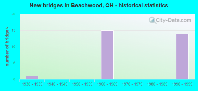
- New bridges - historical statistics
- 11930-1939
- 151960-1969
- 141990-1999

- Reconstructed bridges - Historical Statistics
- 21980-1989
- 41990-1999


- Bridge Condition - Deck
- 7.1%Excellent
- 7.1%Very good
- 71.4%Good
- 14.3%Satisfactory

- Bridge Condition - Superstructure
- 7.1%Excellent
- 42.9%Very good
- 42.9%Good
- 7.1%Satisfactory

- Bridge Condition - Substructure
- 35.7%Very good
- 35.7%Good
- 21.4%Satisfactory
- 7.1%Fair

- Bridge Condition - Channel
- 50.0%Good
- 50.0%Satisfactory

- Bridge Condition - Culverts
- 50.0%Good
- 50.0%Satisfactory
Find on map >> Show street view
Structure Number: 1100068, Location: .34 MI. SW. JCT. SR56 (Lat: 40.049819, Lng: -83.615300), Route carried "on" structure: State highway 4, Year Built: 1931, Year Reconstructed: 1993, Status: Open, Structure Length: 0.67m (2.20ft), Average Daily Traffic: 4,393 (year 2015), Truck Traffic: 16%, Average Future Daily Traffic: 6,097 (year 2035), Design Load: HS 20+Mod, Features Intersected: EAST FORK BUCK CREEK
Minimum Vertical Clearance: 30+ m (98+ ft), Kilometerpoint: 6.341, Lanes on structure: 2, Base Highway Network: Yes, Owner: State Highway Agency, Approaching Roadway Width: 7.3m (24.0ft), Material/Design: Prestressed concrete, Design/Construction: Box Beam or Girders - Multiple, Number Of Spans In Main Unit: 1, Length of Maximum Span: 6.0m (19.7ft), Curb-To-Curb Width: 13.4m (44.0ft), Out-to-Out Width: 13.4m (44.0ft)
Condition: Deck: Excellent, Superstructure: Excellent, Substructure: Good, Channel: Satisfactory, Operating Rating: 42.1 metric tons, Method Used To Determine Operating Rating: Load Factor (LF) rating reported by rating factor (RF) method using MS18 loading, Inventory Rating: 32.4 metric tons, Method Used To Determine Inventory Rating: Load Factor (LF) rating reported by rating factor (RF) method using MS18 loading, Structural Evaluation: Better than present minimum criteria, Deck Geometry: Better than present minimum criteria, Waterway Adequacy: Equal to present desirable criteria, Approach Roadway Alignment: Equal to present minimum criteria, Length Of Structure Improvement: 6.86m (22.51ft), Designated Inspection Frequency: Every 24 months, Inspection Date: January 2021, Bridge Improvement Cost: $110,000, Roadway Improvement Cost: $11,000, Total Project Cost: $131,000, Deck Structure Type: Concrete Cast-file-Place, Wearing Surface/Protective System: Wearing Surface: Bituminous
Find on map >> Show street view
Structure Number: 1811185, Location: .94 MI. N. OF JCT.SR-175 (Lat: 41.449469, Lng: -81.492039), Route carried "on" structure: Interstate 271, Year Built: 1994, Status: Open, Structure Length: 6.34m (20.80ft), Average Daily Traffic: 81,069 (year 2015), Truck Traffic: 9%, Average Future Daily Traffic: 112,524 (year 2035), Design Load: HS 20+Mod, Features Intersected: CR 43 (HARVARD RD)
Minimum Vertical Clearance: 30+ m (98+ ft), Kilometerpoint: 11.587, Lanes on structure: 2, Lanes under structure: 2, Base Highway Network: Yes, Owner: State Highway Agency, Approaching Roadway Width: 17.1m (56.1ft), Skew: 1 degrees, Material/Design: Steel continuous, Design/Construction: Stringer/Multi-beam, Number Of Spans In Main Unit: 3, Length of Maximum Span: 31.1m (102.0ft), Curb-To-Curb Width: 18.3m (60.0ft), Out-to-Out Width: 19.5m (64.0ft)
Condition: Deck: Good, Superstructure: Very good, Substructure: Very good, Operating Rating: 54.4 metric tons, Method Used To Determine Operating Rating: Load Factor (LF) rating reported by rating factor (RF) method using MS18 loading, Inventory Rating: 32.7 metric tons, Method Used To Determine Inventory Rating: Load Factor (LF) rating reported by rating factor (RF) method using MS18 loading, Structural Evaluation: Equal to present desirable criteria, Deck Geometry: Superior to present desirable criteria, Underclear: High priority of corrective action, Approach Roadway Alignment: Equal to present desirable criteria, Designated Inspection Frequency: Every 24 months, Inspection Date: April 2021, Deck Structure Type: Concrete Cast-file-Place, Wearing Surface/Protective System: Wearing Surface: Monolithic Concrete, Deck Protection: Epoxy Coated Reinforcing
Find on map >> Show street view
Structure Number: 1811207, Location: 1 MI. S. OF JCT SR87/422 (Lat: 41.449469, Lng: -81.491769), Route carried "on" structure: Interstate 271X, Year Built: 1993, Status: Open, Structure Length: 6.25m (20.51ft), Average Daily Traffic: 81,069 (year 2015), Truck Traffic: 9%, Average Future Daily Traffic: 112,524 (year 2035), Design Load: HS 20+Mod, Features Intersected: HARVARD RD (CR-43)
Minimum Vertical Clearance: 30+ m (98+ ft), Kilometerpoint: 11.587, Lanes on structure: 2, Lanes under structure: 2, Base Highway Network: Yes, Owner: State Highway Agency, Approaching Roadway Width: 14.9m (48.9ft), Material/Design: Steel continuous, Design/Construction: Stringer/Multi-beam, Number Of Spans In Main Unit: 3, Length of Maximum Span: 29.9m (98.1ft), Curb-To-Curb Width: 14.9m (48.9ft), Out-to-Out Width: 16.0m (52.5ft)
Condition: Deck: Good, Superstructure: Very good, Substructure: Very good, Operating Rating: 45.4 metric tons, Method Used To Determine Operating Rating: Load Factor (LF) rating reported by rating factor (RF) method using MS18 loading, Inventory Rating: 25.9 metric tons, Method Used To Determine Inventory Rating: Load Factor (LF) rating reported by rating factor (RF) method using MS18 loading, Structural Evaluation: Equal to present minimum criteria, Deck Geometry: Superior to present desirable criteria, Underclear: High priority of corrective action, Approach Roadway Alignment: Equal to present desirable criteria, Designated Inspection Frequency: Every 24 months, Inspection Date: April 2021, Deck Structure Type: Concrete Cast-file-Place, Wearing Surface/Protective System: Wearing Surface: Monolithic Concrete, Deck Protection: Epoxy Coated Reinforcing
Find on map >> Show street view
Structure Number: 1811258, Location: JCT. US-422 WITH I-271 (Lat: 41.463731, Lng: -81.491339), Route carried "on" structure: US 422, Year Built: 1962, Year Reconstructed: 2003, Status: Open, Structure Length: 14.51m (47.60ft), Average Daily Traffic: 10,522 (year 2015), Truck Traffic: 2%, Average Future Daily Traffic: 14,605 (year 2035), Design Load: HS 20+Mod, Features Intersected: I-271 (CHAGRIN)
Minimum Vertical Clearance: 30+ m (98+ ft), Kilometerpoint: 18.057, Lanes on structure: 4, Lanes under structure: 6, Base Highway Network: Yes, Owner: State Highway Agency, Approaching Roadway Width: 19.8m (65.0ft), Skew: 12 degrees, Material/Design: Steel continuous, Design/Construction: Stringer/Multi-beam, Number Of Spans In Main Unit: 6, Length of Maximum Span: 29.6m (97.1ft), Curb or Sidewalk Widths: Left: 1.3m (4.3ft), Right: 1.3m (4.3ft), Curb-To-Curb Width: 17.4m (57.1ft), Out-to-Out Width: 20.6m (67.6ft)
Condition: Deck: Good, Superstructure: Satisfactory, Substructure: Fair, Operating Rating: 42.1 metric tons, Method Used To Determine Operating Rating: Allowable Stress (AS) rating reported by rating factor (RF) method using MS18 loading, Inventory Rating: 32.4 metric tons, Method Used To Determine Inventory Rating: Allowable Stress (AS) rating reported by rating factor (RF) method using MS18 loading, Structural Evaluation: Somewhat better than minimum adequacy, Deck Geometry: Somewhat better than minimum adequacy, Underclear: Equal to present minimum criteria, Approach Roadway Alignment: Equal to present desirable criteria, Length Of Structure Improvement: 14.51m (47.60ft), Designated Inspection Frequency: Every 12 months, Inspection Date: November 2021, Bridge Improvement Cost: $1,710,000, Roadway Improvement Cost: $190,000, Total Project Cost: $1,900,000, Deck Structure Type: Concrete Cast-file-Place, Wearing Surface/Protective System: Wearing Surface: Bituminous
Find on map >> Show street view
Structure Number: 1811282, Location: .72 MI. N. OF JCT. US-422 (Lat: 41.473431, Lng: -81.488989), Route carried "on" structure: Interstate 271, Year Built: 1962, Status: Open, Structure Length: 5.09m (16.70ft), Average Daily Traffic: 79,851 (year 2015), Truck Traffic: 9%, Average Future Daily Traffic: 110,833 (year 2035), Design Load: HS 20+Mod, Features Intersected: CR 21 (S. WOODLAND RD)
Minimum Vertical Clearance: 30+ m (98+ ft), Kilometerpoint: 14.243, Lanes on structure: 3, Lanes under structure: 2, Base Highway Network: Yes, Owner: State Highway Agency, Approaching Roadway Width: 17.1m (56.1ft), Material/Design: Steel continuous, Design/Construction: Stringer/Multi-beam, Number Of Spans In Main Unit: 3, Length of Maximum Span: 20.1m (65.9ft), Curb-To-Curb Width: 16.5m (54.1ft), Out-to-Out Width: 17.2m (56.4ft)
Condition: Deck: Good, Superstructure: Good, Substructure: Satisfactory, Operating Rating: 42.1 metric tons, Method Used To Determine Operating Rating: Allowable Stress (AS) rating reported by rating factor (RF) method using MS18 loading, Inventory Rating: 32.4 metric tons, Method Used To Determine Inventory Rating: Allowable Stress (AS) rating reported by rating factor (RF) method using MS18 loading, Structural Evaluation: Equal to present minimum criteria, Deck Geometry: Equal to present minimum criteria, Underclear: Somewhat better than minimum adequacy, Approach Roadway Alignment: Equal to present desirable criteria, Designated Inspection Frequency: Every 12 months, Inspection Date: March 2021, Deck Structure Type: Concrete Cast-file-Place, Wearing Surface/Protective System: Wearing Surface: Monolithic Concrete
Find on map >> Show street view
Structure Number: 181129, Location: .7 MI N OF I-271 & US-422 (Lat: 41.473431, Lng: -81.488661), Route carried "on" structure: Interstate 271X, Year Built: 1995, Status: Open, Structure Length: 4.94m (16.21ft), Average Daily Traffic: 79,851 (year 2015), Truck Traffic: 9%, Average Future Daily Traffic: 110,833 (year 2035), Design Load: HS 20+Mod, Features Intersected: SOUTH WOODLAND ROAD
Minimum Vertical Clearance: 30+ m (98+ ft), Kilometerpoint: 14.243, Lanes on structure: 2, Lanes under structure: 2, Base Highway Network: Yes, Owner: State Highway Agency, Approaching Roadway Width: 14.9m (48.9ft), Skew: 10 degrees, Material/Design: Steel continuous, Design/Construction: Stringer/Multi-beam, Number Of Spans In Main Unit: 3, Length of Maximum Span: 20.1m (65.9ft), Curb-To-Curb Width: 14.9m (48.9ft), Out-to-Out Width: 15.9m (52.2ft)
Condition: Deck: Very good, Superstructure: Very good, Substructure: Very good, Operating Rating: 32.4 metric tons, Method Used To Determine Operating Rating: Load and Resistance Factor Rating (LRFR) rating reported by rating factor(RF) method using HL-93 loadings, Inventory Rating: 25.9 metric tons, Method Used To Determine Inventory Rating: Load and Resistance Factor Rating (LRFR) rating reported by rating factor(RF) method using HL-93 loadings, Structural Evaluation: Equal to present minimum criteria, Deck Geometry: Superior to present desirable criteria, Underclear: High priority of corrective action, Approach Roadway Alignment: Equal to present desirable criteria, Designated Inspection Frequency: Every 24 months, Inspection Date: March 2021, Deck Structure Type: Concrete Cast-file-Place, Wearing Surface/Protective System: Wearing Surface: Monolithic Concrete, Deck Protection: Epoxy Coated Reinforcing
Find on map >> Show street view
Structure Number: 1811347, Location: 1.03 MI. N. OF JCT US-422 (Lat: 41.477800, Lng: -81.488169), Route carried "on" structure: Interstate 271, Year Built: 1962, Year Reconstructed: 1995, Status: Open, Structure Length: 3.90m (12.80ft), Average Daily Traffic: 79,851 (year 2015), Truck Traffic: 9%, Average Future Daily Traffic: 110,833 (year 2035), Design Load: HS 20+Mod, Features Intersected: SHAKER BLVD EB @ MP 30.9
Minimum Vertical Clearance: 30+ m (98+ ft), Kilometerpoint: 14.742, Lanes on structure: 3, Lanes under structure: 2, Base Highway Network: Yes, Owner: State Highway Agency, Approaching Roadway Width: 19.2m (63.0ft), Material/Design: Steel continuous, Design/Construction: Stringer/Multi-beam, Number Of Spans In Main Unit: 3, Length of Maximum Span: 17.7m (58.1ft), Curb-To-Curb Width: 18.7m (61.4ft), Out-to-Out Width: 19.9m (65.3ft)
Condition: Deck: Good, Superstructure: Good, Substructure: Good, Operating Rating: 42.1 metric tons, Method Used To Determine Operating Rating: Allowable Stress (AS) rating reported by rating factor (RF) method using MS18 loading, Inventory Rating: 32.4 metric tons, Method Used To Determine Inventory Rating: Allowable Stress (AS) rating reported by rating factor (RF) method using MS18 loading, Structural Evaluation: Better than present minimum criteria, Deck Geometry: Superior to present desirable criteria, Underclear: High priority of corrective action, Approach Roadway Alignment: Equal to present desirable criteria, Designated Inspection Frequency: Every 24 months, Inspection Date: March 2021, Deck Structure Type: Concrete Cast-file-Place, Wearing Surface/Protective System: Wearing Surface: Monolithic Concrete, Deck Protection: Epoxy Coated Reinforcing
Find on map >> Show street view
Structure Number: 1811355, Location: 1 MI N OF I-271 & US-422 (Lat: 41.477819, Lng: -81.487800), Route carried "on" structure: Interstate 271X, Year Built: 1995, Status: Open, Structure Length: 3.96m (12.99ft), Average Daily Traffic: 79,851 (year 2015), Truck Traffic: 9%, Average Future Daily Traffic: 110,833 (year 2035), Design Load: HS 20+Mod, Features Intersected: SHAKER BLVD EB (CR13A)
Minimum Vertical Clearance: 30+ m (98+ ft), Kilometerpoint: 14.742, Lanes on structure: 2, Lanes under structure: 2, Base Highway Network: Yes, Owner: State Highway Agency, Approaching Roadway Width: 14.9m (48.9ft), Material/Design: Steel continuous, Design/Construction: Stringer/Multi-beam, Number Of Spans In Main Unit: 3, Length of Maximum Span: 17.7m (58.1ft), Curb-To-Curb Width: 14.9m (48.9ft), Out-to-Out Width: 15.9m (52.2ft)
Condition: Deck: Good, Superstructure: Very good, Substructure: Very good, Operating Rating: 42.1 metric tons, Method Used To Determine Operating Rating: Load Factor (LF) rating reported by rating factor (RF) method using MS18 loading, Inventory Rating: 32.4 metric tons, Method Used To Determine Inventory Rating: Load Factor (LF) rating reported by rating factor (RF) method using MS18 loading, Structural Evaluation: Equal to present desirable criteria, Deck Geometry: Superior to present desirable criteria, Underclear: High priority of corrective action, Approach Roadway Alignment: Equal to present desirable criteria, Designated Inspection Frequency: Every 24 months, Inspection Date: March 2021, Deck Structure Type: Concrete Cast-file-Place, Wearing Surface/Protective System: Wearing Surface: Monolithic Concrete, Deck Protection: Epoxy Coated Reinforcing
Find on map >> Show street view
Structure Number: 1811401, Location: 1.61 MI. N. OF JCT US-422 (Lat: 41.486300, Lng: -81.486381), Route carried "on" structure: County highway C0019, Year Built: 1962, Year Reconstructed: 2001, Status: Open, Structure Length: 12.22m (40.09ft), Average Daily Traffic: 8,728 (year 2015), Truck Traffic: 1%, Average Future Daily Traffic: 12,114 (year 2035), Design Load: HS 20+Mod, Features Intersected: IR271&271X (FAIRMOUNT), Facility Carried by Structure: FAIRMOUNT BLVD. WB
Minimum Vertical Clearance: 30+ m (98+ ft), Kilometerpoint: 1.609, Lanes on structure: 2, Lanes under structure: 10, Owner: State Highway Agency, Approaching Roadway Width: 10.4m (34.1ft), Material/Design: Steel continuous, Design/Construction: Stringer/Multi-beam, Number Of Spans In Main Unit: 6, Length of Maximum Span: 21.9m (71.9ft), Curb or Sidewalk Widths: Left: 1.5m (4.9ft), Right: 0.0m, Curb-To-Curb Width: 9.0m (29.5ft), Out-to-Out Width: 11.3m (37.1ft)
Condition: Deck: Satisfactory, Superstructure: Good, Substructure: Satisfactory, Operating Rating: 42.1 metric tons, Method Used To Determine Operating Rating: Load Factor (LF) rating reported by rating factor (RF) method using MS18 loading, Inventory Rating: 32.4 metric tons, Method Used To Determine Inventory Rating: Load Factor (LF) rating reported by rating factor (RF) method using MS18 loading, Structural Evaluation: Equal to present minimum criteria, Deck Geometry: Meets minimum limits, Underclear: High priority of corrective action, Approach Roadway Alignment: Equal to present desirable criteria, Length Of Structure Improvement: 12.22m (40.09ft), Designated Inspection Frequency: Every 12 months, Inspection Date: January 2021, Bridge Improvement Cost: $900,000, Roadway Improvement Cost: $100,000, Total Project Cost: $1,000,000, Deck Structure Type: Concrete Cast-file-Place, Wearing Surface/Protective System: Wearing Surface: Monolithic Concrete, Deck Protection: Epoxy Coated Reinforcing
Find on map >> Show street view
Structure Number: 1811428, Location: 1.1 MI N OF 1-271 & US422 (Lat: 41.479419, Lng: -81.487739), Route carried "on" structure: Interstate 271, Year Built: 1995, Status: Open, Structure Length: 3.90m (12.80ft), Average Daily Traffic: 79,851 (year 2015), Truck Traffic: 9%, Average Future Daily Traffic: 110,833 (year 2035), Design Load: HS 20+Mod, Features Intersected: SHAKER BLVD. W.B.
Minimum Vertical Clearance: 30+ m (98+ ft), Kilometerpoint: 14.903, Lanes on structure: 3, Lanes under structure: 2, Base Highway Network: Yes, Owner: State Highway Agency, Approaching Roadway Width: 20.1m (65.9ft), Skew: 10 degrees, Material/Design: Steel continuous, Design/Construction: Stringer/Multi-beam, Number Of Spans In Main Unit: 3, Length of Maximum Span: 17.7m (58.1ft), Curb-To-Curb Width: 21.4m (70.2ft), Out-to-Out Width: 22.6m (74.1ft)
Condition: Deck: Good, Superstructure: Very good, Substructure: Good, Operating Rating: 42.1 metric tons, Method Used To Determine Operating Rating: Load Factor (LF) rating reported by rating factor (RF) method using MS18 loading, Inventory Rating: 32.4 metric tons, Method Used To Determine Inventory Rating: Load Factor (LF) rating reported by rating factor (RF) method using MS18 loading, Structural Evaluation: Better than present minimum criteria, Deck Geometry: Superior to present desirable criteria, Underclear: High priority of corrective action, Approach Roadway Alignment: Equal to present desirable criteria, Designated Inspection Frequency: Every 24 months, Inspection Date: Febuary 2021, Deck Structure Type: Concrete Cast-file-Place, Wearing Surface/Protective System: Wearing Surface: Monolithic Concrete, Deck Protection: Epoxy Coated Reinforcing
Find on map >> Show street view
Structure Number: 1811436, Location: 1.59 MI. N. OF JCT US-422 (Lat: 41.486161, Lng: -81.486489), Route carried "on" structure: County highway C0019, Year Built: 1962, Year Reconstructed: 2001, Status: Open, Structure Length: 12.22m (40.09ft), Average Daily Traffic: 8,728 (year 2015), Truck Traffic: 1%, Average Future Daily Traffic: 12,114 (year 2035), Design Load: HS 20+Mod, Features Intersected: IR271&271X (FAIRMOUNT), Facility Carried by Structure: FAIRMOUNT BLVD. EB
Minimum Vertical Clearance: 30+ m (98+ ft), Kilometerpoint: 15.643, Lanes on structure: 2, Lanes under structure: 10, Owner: State Highway Agency, Approaching Roadway Width: 10.4m (34.1ft), Material/Design: Steel continuous, Design/Construction: Stringer/Multi-beam, Number Of Spans In Main Unit: 6, Length of Maximum Span: 21.9m (71.9ft), Curb or Sidewalk Widths: Left: 0.0m, Right: 1.5m (4.9ft), Curb-To-Curb Width: 9.0m (29.5ft), Out-to-Out Width: 11.3m (37.1ft)
Condition: Deck: Satisfactory, Superstructure: Good, Substructure: Satisfactory, Operating Rating: 42.1 metric tons, Method Used To Determine Operating Rating: Load Factor (LF) rating reported by rating factor (RF) method using MS18 loading, Inventory Rating: 32.4 metric tons, Method Used To Determine Inventory Rating: Load Factor (LF) rating reported by rating factor (RF) method using MS18 loading, Structural Evaluation: Equal to present minimum criteria, Deck Geometry: High priority of corrective action, Underclear: High priority of corrective action, Approach Roadway Alignment: Equal to present desirable criteria, Length Of Structure Improvement: 12.22m (40.09ft), Designated Inspection Frequency: Every 12 months, Inspection Date: January 2021, Bridge Improvement Cost: $900,000, Roadway Improvement Cost: $100,000, Total Project Cost: $1,000,000, Deck Structure Type: Concrete Cast-file-Place, Wearing Surface/Protective System: Wearing Surface: Monolithic Concrete, Deck Protection: Epoxy Coated Reinforcing
Find on map >> Show street view
Structure Number: 1811479, Location: 1.1 MI N OF I-271 & US422 (Lat: 41.479350, Lng: -81.487439), Route carried "on" structure: Interstate 271X, Year Built: 1995, Status: Open, Structure Length: 3.90m (12.80ft), Average Daily Traffic: 79,851 (year 2015), Truck Traffic: 9%, Average Future Daily Traffic: 110,833 (year 2035), Design Load: HS 20+Mod, Features Intersected: SHAKER BLVD W.B.
Minimum Vertical Clearance: 30+ m (98+ ft), Kilometerpoint: 14.903, Lanes on structure: 2, Lanes under structure: 2, Base Highway Network: Yes, Owner: State Highway Agency, Approaching Roadway Width: 14.9m (48.9ft), Material/Design: Steel continuous, Design/Construction: Stringer/Multi-beam, Number Of Spans In Main Unit: 3, Length of Maximum Span: 17.7m (58.1ft), Curb-To-Curb Width: 14.9m (48.9ft), Out-to-Out Width: 15.9m (52.2ft)
Condition: Deck: Good, Superstructure: Very good, Substructure: Very good, Operating Rating: 68.0 metric tons, Method Used To Determine Operating Rating: Load and Resistance Factor Rating (LRFR) rating reported by rating factor(RF) method using HL-93 loadings, Inventory Rating: 55.1 metric tons, Method Used To Determine Inventory Rating: Load and Resistance Factor Rating (LRFR) rating reported by rating factor(RF) method using HL-93 loadings, Structural Evaluation: Equal to present desirable criteria, Deck Geometry: Superior to present desirable criteria, Underclear: High priority of corrective action, Approach Roadway Alignment: Equal to present desirable criteria, Designated Inspection Frequency: Every 24 months, Inspection Date: Febuary 2021, Deck Structure Type: Concrete Cast-file-Place, Wearing Surface/Protective System: Wearing Surface: Monolithic Concrete, Deck Protection: Epoxy Coated Reinforcing
Find on map >> Show street view
Structure Number: 1834622, Location: BETWEEN I-271 & W. RAMPS (Lat: 41.449761, Lng: -81.492419), Route carried "on" structure: County highway C0043, Year Built: 1999, Status: Open, Structure Length: 0.87m (2.85ft), Average Daily Traffic: 23,709 (year 2015), Truck Traffic: 17%, Average Future Daily Traffic: 32,908 (year 2035), Design Load: H 15, Features Intersected: BRANCH TINKERS CREEK, Facility Carried by Structure: HARVARD ROAD CR 43
Minimum Vertical Clearance: 30+ m (98+ ft), Kilometerpoint: 16.576, Lanes on structure: 6, Owner: County Highway Agency, Approaching Roadway Width: 26.2m (86.0ft), Skew: 1 degrees, Material/Design: Concrete, Design/Construction: Culvert, Number Of Spans In Main Unit: 2, Length of Maximum Span: 4.0m (13.1ft)
Condition: Channel: Good, Culverts: Satisfactory, Operating Rating: 96.6 metric tons, Method Used To Determine Operating Rating: Load Factor (LF) rating reported by rating factor (RF) method using MS18 loading, Inventory Rating: 58.0 metric tons, Method Used To Determine Inventory Rating: Load Factor (LF) rating reported by rating factor (RF) method using MS18 loading, Structural Evaluation: Equal to present minimum criteria, Waterway Adequacy: Equal to present desirable criteria, Approach Roadway Alignment: Superior to present desirable criteria, Designated Inspection Frequency: Every 12 months, Inspection Date: June 2021
Find on map >> Show street view
Structure Number: 1901117, Location: JCT. USR-127 (Lat: 40.067189, Lng: -84.620161), Route carried "on" structure: State highway 49, Year Built: 1968, Year Reconstructed: 1986, Status: Open, Structure Length: 6.13m (20.11ft), Average Daily Traffic: 7,190 (year 2015), Truck Traffic: 11%, Average Future Daily Traffic: 9,980 (year 2035), Design Load: H 20, Features Intersected: USR 36 AND 127
Minimum Vertical Clearance: 30+ m (98+ ft), Kilometerpoint: 22.692, Lanes on structure: 2, Lanes under structure: 4, Base Highway Network: Yes, Owner: State Highway Agency, Approaching Roadway Width: 13.4m (44.0ft), Material/Design: Steel continuous, Design/Construction: Stringer/Multi-beam, Number Of Spans In Main Unit: 4, Length of Maximum Span: 17.7m (58.1ft), Curb-To-Curb Width: 13.4m (44.0ft), Out-to-Out Width: 14.0m (45.9ft)
Condition: Deck: Good, Superstructure: Good, Substructure: Good, Operating Rating: 55.1 metric tons, Method Used To Determine Operating Rating: Load and Resistance Factor Rating (LRFR) rating reported by rating factor(RF) method using HL-93 loadings, Inventory Rating: 42.1 metric tons, Method Used To Determine Inventory Rating: Load and Resistance Factor Rating (LRFR) rating reported by rating factor(RF) method using HL-93 loadings, Structural Evaluation: Better than present minimum criteria, Deck Geometry: Equal to present minimum criteria, Underclear: High priority of corrective action, Approach Roadway Alignment: Equal to present desirable criteria, Designated Inspection Frequency: Every 24 months, Inspection Date: May 2021, Deck Structure Type: Concrete Cast-file-Place, Wearing Surface/Protective System: Wearing Surface: Integral Concrete
Find on map >> Show street view
Structure Number: 1901575, Location: 4.38MI.N. OF JCT. SR-571 (Lat: 40.161189, Lng: -84.637211), Route carried "on" structure: State highway 118, Year Built: 1993, Status: Open, Structure Length: 0.67m (2.20ft), Average Daily Traffic: 4,004 (year 2015), Truck Traffic: 4%, Average Future Daily Traffic: 5,558 (year 2035), Design Load: HS 20+Mod, Features Intersected: BRANCH OF BOYD CREEK
Minimum Vertical Clearance: 30+ m (98+ ft), Kilometerpoint: 7.049, Lanes on structure: 2, Owner: State Highway Agency, Approaching Roadway Width: 7.3m (24.0ft), Material/Design: Concrete, Design/Construction: Culvert, Number Of Spans In Main Unit: 1, Length of Maximum Span: 6.1m (20.0ft)
Condition: Channel: Satisfactory, Culverts: Good, Operating Rating: 64.8 metric tons, Method Used To Determine Operating Rating: Load Factor (LF) rating reported by rating factor (RF) method using MS18 loading, Inventory Rating: 42.1 metric tons, Method Used To Determine Inventory Rating: Load Factor (LF) rating reported by rating factor (RF) method using MS18 loading, Structural Evaluation: Better than present minimum criteria, Waterway Adequacy: Equal to present desirable criteria, Approach Roadway Alignment: Equal to present desirable criteria, Designated Inspection Frequency: Every 24 months, Inspection Date: May 2021
Find on map >> Show street view
Structure Number: 1901834, Location: 2.81 MI. S. MERCER CO. (Lat: 40.312181, Lng: -84.637081), Route carried "on" structure: State highway 118, Year Built: 1962, Status: Open, Structure Length: 4.94m (16.21ft), Average Daily Traffic: 1,527 (year 2015), Truck Traffic: 8%, Average Future Daily Traffic: 2,119 (year 2035), Design Load: H 15, Features Intersected: WABASH RIVER
Minimum Vertical Clearance: 30+ m (98+ ft), Kilometerpoint: 23.915, Lanes on structure: 2, Owner: State Highway Agency, Approaching Roadway Width: 12.5m (41.0ft), Material/Design: Steel continuous, Design/Construction: Stringer/Multi-beam, Number Of Spans In Main Unit: 3, Length of Maximum Span: 18.3m (60.0ft), Curb-To-Curb Width: 12.2m (40.0ft), Out-to-Out Width: 12.2m (40.0ft)
Condition: Deck: Good, Superstructure: Good, Substructure: Good, Channel: Good, Operating Rating: 32.4 metric tons, Method Used To Determine Operating Rating: Load Factor (LF) rating reported by rating factor (RF) method using MS18 loading, Inventory Rating: 25.9 metric tons, Method Used To Determine Inventory Rating: Load Factor (LF) rating reported by rating factor (RF) method using MS18 loading, Structural Evaluation: Equal to present minimum criteria, Deck Geometry: Better than present minimum criteria, Waterway Adequacy: Better than present minimum criteria, Approach Roadway Alignment: Better than present minimum criteria, Designated Inspection Frequency: Every 24 months, Underwater Inspection Frequency: Every 60 months, Inspection Date: June 2021, Underwater Inspection Date: August 2017, Deck Structure Type: Concrete Cast-file-Place, Wearing Surface/Protective System: Wearing Surface: Monolithic Concrete
Find on map >> Show street view
Structure Number: 1811185, Location: .94 MI. N. OF JCT.SR-175 (Lat: 41.449469, Lng: -81.492039), Route carried "under" structure: County highway 43, Year Built: 1994, Structure Length: 0. m, Average Daily Traffic: 10,000 (year 1994), Truck Traffic: 10%, Features Intersected: I-271-720L, Facility Carried by Structure: IR 271 N.B.
Minimum Vertical Clearance: 5.13m (16.83ft), Kilometerpoint: 15.578, Lanes on structure: 2, Lanes under structure: 2, Material/Design: Steel continuous, Design/Construction: Stringer/Multi-beam, Length of Maximum Span: 31.1m (102.0ft)
Find on map >> Show street view
Structure Number: 1811207, Location: 1 MI. S. OF JCT SR87/422 (Lat: 41.449469, Lng: -81.491769), Route carried "under" structure: County highway C0043, Year Built: 1993, Structure Length: 0. m, Average Daily Traffic: 10,000 (year 1994), Truck Traffic: 10%, Features Intersected: IR-271X, Facility Carried by Structure: IR 271X
Minimum Vertical Clearance: 5.46m (17.91ft), Kilometerpoint: 30.771, Lanes on structure: 2, Lanes under structure: 2, Material/Design: Steel continuous, Design/Construction: Stringer/Multi-beam, Length of Maximum Span: 29.9m (98.1ft)
Find on map >> Show street view
Structure Number: 1811258, Location: JCT. US-422 WITH I-271 (Lat: 41.463731, Lng: -81.491339), Route carried "under" structure: Interstate 271, Year Built: 1962, Structure Length: 0. m, Average Daily Traffic: 139,394 (year 2015), Truck Traffic: 9%, Features Intersected: US-422 (1122) CHAGRIN BL, Facility Carried by Structure: USR 422
Minimum Vertical Clearance: 5.24m (17.19ft), Kilometerpoint: 13.084, Lanes on structure: 4, Lanes under structure: 6, Material/Design: Steel continuous, Design/Construction: Stringer/Multi-beam, Length of Maximum Span: 29.6m (97.1ft)
Find on map >> Show street view
Structure Number: 1811258, Location: JCT. US-422 WITH I-271 (Lat: 41.463731, Lng: -81.491339), Route carried "under" structure: Interstate 271X, Year Built: 1962, Structure Length: 0. m, Features Intersected: US-422 (1122) CHAGRIN BL, Facility Carried by Structure: USR 422
Minimum Vertical Clearance: 5.32m (17.45ft), Kilometerpoint: 13.084, Lanes on structure: 4, Lanes under structure: 6, Material/Design: Steel continuous, Design/Construction: Stringer/Multi-beam, Length of Maximum Span: 29.6m (97.1ft)
Find on map >> Show street view
Structure Number: 1811282, Location: .72 MI. N. OF JCT. US-422 (Lat: 41.473431, Lng: -81.488989), Route carried "under" structure: County highway 21, Year Built: 1962, Structure Length: 0. m, Average Daily Traffic: 5,110 (year 1970), Features Intersected: I-271, Facility Carried by Structure: IR 271 S.B.
Minimum Vertical Clearance: 4.40m (14.44ft), Kilometerpoint: 10.960, Lanes on structure: 3, Lanes under structure: 2, Material/Design: Steel continuous, Design/Construction: Stringer/Multi-beam, Length of Maximum Span: 20.1m (65.9ft)
Find on map >> Show street view
Structure Number: 181129, Location: .7 MI N OF I-271 & US-422 (Lat: 41.473431, Lng: -81.488661), Route carried "under" structure: County highway 21, Year Built: 1995, Structure Length: 0. m, Average Daily Traffic: 5,110 (year 1970), Features Intersected: IR-271X, Facility Carried by Structure: 1R 271X S.B.
Minimum Vertical Clearance: 5.21m (17.09ft), Kilometerpoint: 14.645, Lanes on structure: 2, Lanes under structure: 2, Material/Design: Steel continuous, Design/Construction: Stringer/Multi-beam, Length of Maximum Span: 20.1m (65.9ft)
Find on map >> Show street view
Structure Number: 1811347, Location: 1.03 MI. N. OF JCT US-422 (Lat: 41.477800, Lng: -81.488169), Route carried "under" structure: County highway 13A, Year Built: 1962, Structure Length: 0. m, Average Daily Traffic: 9,720 (year 1970), Truck Traffic: 1%, Features Intersected: I-271, Facility Carried by Structure: IR 271 SB
Minimum Vertical Clearance: 4.57m (14.99ft), Kilometerpoint: 0.806, Lanes on structure: 3, Lanes under structure: 2, Material/Design: Steel continuous, Design/Construction: Stringer/Multi-beam, Length of Maximum Span: 17.7m (58.1ft)
Find on map >> Show street view
Structure Number: 1811355, Location: 1 MI N OF I-271 & US-422 (Lat: 41.477819, Lng: -81.487800), Route carried "under" structure: County highway 13A, Year Built: 1995, Structure Length: 0. m, Average Daily Traffic: 4,860 (year 1970), Truck Traffic: 1%, Features Intersected: IR-271X, Facility Carried by Structure: 1R 271X SB
Minimum Vertical Clearance: 4.57m (14.99ft), Kilometerpoint: 0.832, Lanes on structure: 2, Lanes under structure: 2, Material/Design: Steel continuous, Design/Construction: Stringer/Multi-beam, Length of Maximum Span: 17.7m (58.1ft)
Find on map >> Show street view
Structure Number: 1811401, Location: 1.61 MI. N. OF JCT US-422 (Lat: 41.486300, Lng: -81.486381), Route carried "under" structure: Interstate 271X, Year Built: 1962, Structure Length: 0. m, Average Daily Traffic: 134,810 (year 2010), Truck Traffic: 11%, Features Intersected: CR-19 (FAIRMOUNT BLVD WB, Facility Carried by Structure: FAIRMOUNT BLVD. WB
Minimum Vertical Clearance: 5.59m (18.34ft), Kilometerpoint: 15.675, Lanes on structure: 2, Lanes under structure: 10, Material/Design: Steel continuous, Design/Construction: Stringer/Multi-beam, Length of Maximum Span: 21.9m (71.9ft)
Find on map >> Show street view
Structure Number: 1811401, Location: 1.61 MI. N. OF JCT US-422 (Lat: 41.486300, Lng: -81.486381), Route carried "under" structure: Interstate 271, Year Built: 1962, Structure Length: 0. m, Average Daily Traffic: 134,810 (year 2010), Truck Traffic: 11%, Features Intersected: CR-19 (FAIRMOUNT BLVD WB, Facility Carried by Structure: FAIRMOUNT BLVD. WB
Minimum Vertical Clearance: 5.85m (19.19ft), Kilometerpoint: 15.675, Lanes on structure: 2, Lanes under structure: 10, Material/Design: Steel continuous, Design/Construction: Stringer/Multi-beam, Length of Maximum Span: 21.9m (71.9ft)
Find on map >> Show street view
Structure Number: 1811428, Location: 1.1 MI N OF 1-271 & US422 (Lat: 41.479419, Lng: -81.487739), Route carried "under" structure: County highway 13, Year Built: 1995, Structure Length: 0. m, Average Daily Traffic: 4,860 (year 1970), Features Intersected: 1-271 S.B., Facility Carried by Structure: 1R 271 S.B.
Minimum Vertical Clearance: 4.47m (14.67ft), Kilometerpoint: 43.629, Lanes on structure: 3, Lanes under structure: 2, Material/Design: Steel continuous, Design/Construction: Stringer/Multi-beam, Length of Maximum Span: 17.7m (58.1ft)
Find on map >> Show street view
Structure Number: 1811436, Location: 1.59 MI. N. OF JCT US-422 (Lat: 41.486161, Lng: -81.486489), Route carried "under" structure: Interstate 271X, Year Built: 1962, Structure Length: 0. m, Features Intersected: CR-19 (FAIRMOUNT BLVD EB, Facility Carried by Structure: FAIRMOUNT BLVD. EB
Minimum Vertical Clearance: 6.07m (19.91ft), Kilometerpoint: 15.643, Lanes on structure: 2, Lanes under structure: 10, Material/Design: Steel continuous, Design/Construction: Stringer/Multi-beam, Length of Maximum Span: 21.9m (71.9ft)
Find on map >> Show street view
Structure Number: 1811436, Location: 1.59 MI. N. OF JCT US-422 (Lat: 41.486161, Lng: -81.486489), Route carried "under" structure: Interstate 271, Year Built: 1962, Structure Length: 0. m, Average Daily Traffic: 134,810 (year 2010), Truck Traffic: 11%, Features Intersected: CR-19 (FAIRMOUNT BLVD EB, Facility Carried by Structure: FAIRMOUNT BLVD. EB
Minimum Vertical Clearance: 5.58m (18.31ft), Kilometerpoint: 15.643, Lanes on structure: 2, Lanes under structure: 10, Material/Design: Steel continuous, Design/Construction: Stringer/Multi-beam, Length of Maximum Span: 21.9m (71.9ft)
Find on map >> Show street view
Structure Number: 1811479, Location: 1.1 MI N OF I-271 & US422 (Lat: 41.479350, Lng: -81.487439), Route carried "under" structure: County highway 13, Year Built: 1995, Structure Length: 0. m, Average Daily Traffic: 4,860 (year 1970), Features Intersected: IR-271X, Facility Carried by Structure: IR 271X S.B.
Minimum Vertical Clearance: 4.34m (14.24ft), Kilometerpoint: 8.224, Lanes on structure: 2, Lanes under structure: 2, Material/Design: Steel continuous, Design/Construction: Stringer/Multi-beam, Length of Maximum Span: 17.7m (58.1ft)